Here is the second part of our email which continues on from the quotes derived from the 2002 Housing Strategy.
“There is plenty more in this document and it reads well. I have just concentrated on residential development, population estimates, and the public realm issue in the wider sense. It would be good if Councillors concerned with overdevelopment, high rate of residential development and the type of development and its consequential very high population increase could pursue the review of the Housing and Residential Development Strategy. It only needs 5 Councillors and it seems that Cr Lobo and Cr Sounness, as the one with some town planning background could start the ball rolling by first asking how many action points have been implemented. So how did Glen Eira actually develop? Let me expand on the issues raised and its problems.
The residential development is always greater than forecast by a significant amount. In 1996 it was 300 dwellings per year, 2001 over 600 dwellings per year, and 2006 and beyond nearly 900 dwellings per year. And the current building applications are close to 1200 per year. It is not clear if building application means 1 dwelling or a number of dwellings. Clearly, the rate of development is much greater than anticipated and there has to be a reason for that. Is the Council doing its job to ensure that infrastructure, public realm and services are there for such a large development rate?
The result of all that development is the population explosion in Glen Eira (http://profile.id.com.au/glen-eira/population-estimate ). In 1996 it was around 115,000 with projected figures of 121,000 by 2020. In 2001 it was 123,000 with a forecast of 130,000 by 2021. In 2006 it was 130,000 with estimates of 136,000 by 2011, 148,000 by 2021 and 157,000 by 2031 (forecast2.id.com.au/templates/forecast2/Clients/133Glen/PDF/10.pdf ).
In the 2002 document the capacity for multi-dwelling developments (lot availability) was estimated to be in the order of 10,000 dwellings to be used up by 2020. This estimate depends on the density of dwellings built. We suggest it is a gross underestimate. Over 6,000 dwellings have already been built. The service reports indicate that 80% of those are in the housing diversity areas, so 5,000 dwellings have already taken up the available lots. With greater density being built one can safely assume another 10,000 dwellings can be built in the housing diversity areas. The population under such condition is likely to grow to 160,000 by 2021 and 180,000 by 2031. Properly conducted structure plans as suggested in 2002 would elucidate more accurately the lot availability and density of dwellings. As it is now, Councillors and the community are left deliberately in darkness.
But there is more. The sleeper issue is the minimal change area. Once the pressure is on to develop it will. So what is the capacity for developments in this area since it is 4 times bigger than housing diversity area. The 2002 report gives a figure of 5,000 dwelling opportunity for low density developments in housing diversity area. With the existing rules for dual occupancy, single or double storey units, flats and subdivision, all allowed in minimal change area, the end point of 20,000 dwellings is not unreasonable. Assuming a very low no. of 2 to 3 people per dwelling we get a whopping population of over 220,000 perhaps by 2041. The population density in 1996 was 29.7 per hectare growing to a 41.4 by 2021 and 56.9 persons per hectare by 2041. Clearly, such an influx of people with nearly double the density will have major implications on the character, lifestyle and liveability of Glen Eira. Is there evidence of minimal change areas developments? YES. Take Bentleigh East with the largest minimal change area and the smallest population density. The dwelling growth of medium density housing between 1996 and 2011 was 127% as opposed to only 26% in Glen Eira overall i.e. more than 4 times the average. Councillors should ask for details of each suburb growth patterns in terms of medium density and high density. The pressure to develop is on everywhere. What are we building? Is the Council ready for it?
Nearly all developments outlined are suitable for small time developers, who like Glen Eira Council focus on a single project at a time. Koornang Rd Carnegie has exceeded its electricity power capacity and requires a new sub-station to be built. Jemena, the infrastructure provider will not provide more electricity than necessary if it is a case-by-case approach rather than an area approach. Ormond has a number of recently built apartment blocks erected from concrete. When you flush a toilet, you can hear it throughout the building. Quality is not there and they will become rental slums. Ormond – Glen Huntly reached the dubious distinction of the greatest population density increase of suburbs in Melbourne (http://chartingtransport.com/2012/09/21/first-look-2011-density/ ). Why? And what about water supply and drainage? Are we sufficiently ready for the over 200,000 people living in Glen Eira?
Now to the level crossings of which Glen Eira has 9. Work on North Rd level crossing begins with Murrumbeena Rd being next. The Department of Premier and Cabinet website says: “A program of level crossing removal will contribute to improved productivity and safety outcomes in Melbourne and improved land use outcomes by supporting urban renewal to cater for Melbourne’s growth.” (http://www.dpc.vic.gov.au/index.php/featured/infrastructure-australia-update/ia-appendix). One of the criteria for priority level crossing removal is urban renewal, which means more residential development in the area. Lowering of the rail provides more opportunities than having a flyover rail line, although it is probably cheaper. With $100m to remove a level crossing the State Government is looking for funding from private corporations. They are willing to do that for a price (http://www.afr.com/p/national/cash_cocktail_for_melbourne_rail_Sgxu1YvQcayPIEk9lqWwoK ). If private capital is to fund the level crossing removal then what development would cover such a cost?
Caulfield Village development gives a clue to that with about 7 to 10 times the value of level crossing removal i.e. $700m to $1billion. That would provide a huge injection of capital into the Ormond area. Businesses and traders will support it wholeheartedly. The result for residents may not be that great. The Dorothy Ave bridge would disappear and Dorothy Ave, Royal Ave, Katandra St, and the land around Ormond station redeveloped. This development is for the ‘big boys’. Similar consideration goes for Murrumbeena Rd. Of course if the Committee for Melbourne would have their way they would prefer to do a sequence of level crossings e.g. from Caulfield to Patterson (Frankston line) and from Caulfield to Oakleigh (Dandenong line). Each level crossing removal could add few thousand people into the area. With 9 of them in Glen Eira we could see another 20,000 to 30,000 people. How long would it take? Committee for Melbourne claims they can do it in 20 years. So by 2041 we could see a population of 250,000 (http://blogs.crikey.com.au/theurbanist/2011/08/16/should-replacing-level-crossings-be-given-high-priority/).
One has to ask how all this development affects the Public Realm, which is the responsibility of every Local Government. Glen Eira Council has no definition of Public Realm and has a narrow focus on Open Space. Stonnington Council has developed a Public Realm Strategy (http://www.stonnington.vic.gov.au/your-council/strategies/ ) – “This Strategy extends the typical open space strategy, which includes ‘green spaces’ such as gardens and parks, to the broader understanding of the public realm, which includes all external space that is available for public use”. And it illustrates the concept with the following diagram
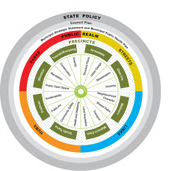 The diagram illustrates the context in which this Strategy operates. The outer layer identifies the broader State policies that govern public space policy in Victoria. The next layer identifies the Council Plan as Stonnington’s key strategic document. The next layer shows both the Municipal Public Health Plan and the Municipal Strategic Statement. The Public Realm follows, and includes streets, parks, hubs and links. Stonnington’s public realm is further divided into suburbs and the many elements from across Council that form the core of the Public Realm Strategy.
Glen Eira Council is conducting a Survey to review its Open Space Strategy – “Open space is all publicly owned land that is set aside primarily for recreation, passive outdoor enjoyment and nature conservation” and the Strategy “includes planning ahead for the provision and design of open space to meet the needs of the anticipated future population”. How they can do it without an integrated approach to planning and by letting developers drive the City growth is a question to be asked. When one examines Glen Eira Council Strategies one gets the feeling it is for administrative/public relations purposes. Look at the Stonnington Council Strategies and one feels more confident in their ability to plan comprehensively and manage their plans in an integrated way.
Perhaps we may as well ask again after Cr Lobo – ‘are we building Calcutta or Richmond’. Over to you Councillors.

February 15, 2013 at 5:00 PM
I vote for SCR as mayor and ceo. He or she puts them all to shame.
February 16, 2013 at 9:11 AM
A gloomy but convincing picture. Slumsville is already present in East Caulfield Dudley Street and that’s nominally minimal change. East Bentleigh is next and even North Caulfield. Drawing arbitrary lines on a map over 10 years ago is not planning without proper investigation of all the other elements such as drainage, power, open space, transport, and so on.
I congratulate Seriously concerned resident for his work. It should send shudders through all councillors and make them start asking some serious questions of this highly incompetent administration. What have they been doing for the past 12 years?