We urge all residents to have a very close look at the zoning map presented below.
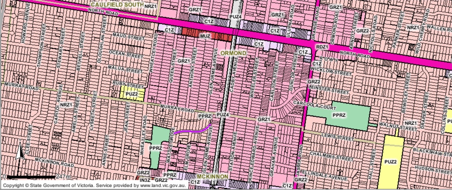
It illustrates completely the utter incompetence, indifference, and shoddy planning processes that exemplify this administration and its councillors – the latter who are supposed to set policy, oversee strategic direction and most importantly, represent their constituents when they make decisions. Instead, residents are now paying the price for such shoddy planning and the egos that were so determined to be first cab off the rank when it came to introducing the new zones – without consultation we repeat!
The map focuses on the McKinnon Neighbourhood Centre. We would like residents to ponder the following and then ask the creators of this scheme, and especially the Mayor of the time (Hyams) who was party to the secret ‘negotiations’, to justify and answer the following:
- The total inconsistency. If promimity to railway stations is the stated criteria, then why are some streets (ie Hawthorn Grove) zoned minimal change when they are one street away from rail, and other streets that are up to four blocks away are zoned GRZ?
- If the argument is that there is a nearby park, then surely it would have made more sense that medium/higher density dwellings go into areas that are served by open space given the planning scheme’s failure to cater for open space requirements in the GRZ and RGZ schedules and council’s appalling record in acquiring open space?
- How was this zoning drawn up? Is it concentric, rectangular, or more of a pin the tail on the donkey exercise? Did any officer, or councillor ever walk along these streets and get a ‘feel’ for the neighbourhood? Why can one side of a very, very narrow street (Murrary Road) be designated as minimal change and the opposite side of the street deemed to be general residential zone?
- Why should the 12th house in a street be earmarked as suitable for 3 storey development and the 13th house be plonked into neighbourhood residential zone?
- Why can other councils undertake exhaustive reviews of their Housing Strategies PRIOR to introducing their zones and Glen Eira hasn’t touched theirs since 2000?
- How can Hyams and others keep repeating the inane mantra that there was no consultation because the outcomes would have been worse! This argument alone is the most damning indictment of all councillors and the administration. Not only does it reek of arrogance but displays a total disdain for all aspects of democratic process and transparency.

September 9, 2014 at 9:32 AM
hyam has never been interested in democracy, he has a singlar insterest of delivering as much as possible to his own community
September 9, 2014 at 10:52 AM
Hyams has a bad case of the well known big fish little pond syndrome. Lets hope it becomes fatal at the next elections.
September 9, 2014 at 12:15 PM
There is crazy stuff all through this map. I don’t know why some streets on the other side of North Road are in the growth zone when they are local streets nowhere near a train station and no commercial buildings around them. It looks like someone was sitting in their office and just drew lines on a map willy nilly.
September 9, 2014 at 1:29 PM
What’s very shocking about the map is that between North, Wheatly, Jasper and McKinnon roads there are probably around 1000 properties that can now have 3 storeys put up on them. Even if only 3 or 4 of such developments go up in each street that is still a humungous growth in apartments and changes forever the streets themselves. Then if people continue to combine and sell their land as 3 or 4 blocks together, the developments will be even larger and fully supported by council. What this does to traffic and parking because council is very good at waiving car parking places is more mayhem on the roads and a deterioration of safety and living standards.
I also object strongly to the fact that noone was given the opportunity to have a say and that all residents of the new zones in housing diversity are being treated like second class citizens. They don’t deserve open space, parking, trees, or balconies that would even allow a table to be put outside.
September 9, 2014 at 4:21 PM
A mate lives in Dunlop Avenue. He tells me that his land is over 800 sqm and plenty of others too. Perfect for subdivisions and huge developments if he teams up with neighbours. Money for jam if 1112 metres can get 3.61 mill in McKinnon.
September 9, 2014 at 6:08 PM
Says a lot for the way Council implemented the zones doesn’t it. Deciding to sell the family home is an emotional, financial and physical drain. It’s not something taken lightly.
That fact that these residents and groups of residents are deciding to sell is not taking advantage of the cash cow handed to them by Council. It’s because they have seen the writing that Council has boldly written on the wall and, having had years of frustrating dealings with Council, they have finally decided that any where other than Glen Eira is the place to be.
You can’t blame VCAT or the Government for Council’s piss poor implementation – yeah sure the tools were given to them but they were the one’s that decided how to use them.
And contrary to the “do it once and do it properly, that’s the Glen Eira way”, the only thing they have done properly is f*ck up.
September 9, 2014 at 6:22 PM
Council’s housing policies were developed over 10 years ago and don’t reflect the feedback they received from the portions of the community they consulted then. It is disingenous for them to claim that the policies were prepared “through widespread community consultation”. The bizarre anomalies and inconsistencies show that there never was a coherent set of principles behind the choice of properties to be included in “Housing Diversity” [sic] or “Urban Village” areas.
Part of the problem with being zoned GRZ/RGZ/MUZ/C1Z is that planning decisions are biased towards filling the maximum building envelope possible rather than complying with any of the policies and standards that might constrain a development. One possible definition of overdevelopment is when a proposal fails to comply with residential amenity standards and related policies. I don’t agree with Council that overshadowing is acceptable for example, or that people in Housing Diversity areas aren’t entitled to similar standards of amenity as elsewhere.
When Council decided to grant parking waivers for recent developments in Morton Av Carnegie, an area where parking is under great pressure, they were doing so in the full knowledge that the railway carpark was already inadequate and that as a result patrons were being forced into surrounding streets. It violated policy. And it was on top of the waiver previously granted to the notorious 9 Morton Av, in which not a single unit of the 15 on the 4th storey has a parking space.
C110 wasn’t a “direct translation” of policy and wasn’t “neutral”. Despite this Council requested the Minister approve it, and he obliged. It should have been through the normal planning amendment process to establish the amenity standards specified for each zone, along with some actual decision criteria rather than the current crap. While Council’s behaviour re C110 was appalling, it will come as no surprise that past and current Mayors defend their secret decisions.
September 9, 2014 at 9:20 PM
Practically every single multi-unit application in housing diversity includes a waiver of resident or visitor car parking. For the sake of argument, let’s assume that at least one car parking spot is waived either by council or vcat and that there are around 12000 (a conservative estimate) of properties in housing diversity. That means that 12000 spots at least will be filled in already overcrowded and over parked neighbouring streets.
Then, if one investigates what the planning scheme says, like implementing parking precinct plans, we might as well be waiting until the cows come home before this council enacts anything it promises to do.
September 11, 2014 at 1:43 PM
And lets not forget that many of these streets in McKinnon were subject to severe flooding only 3 years ago. What re-evaluation of zoning, and the impact of higher density, was done in light of that incident? (rhetorical question)
September 11, 2014 at 3:22 PM
Possibly a far more pertinent question would be how much has council spent on updating its own drains in these flood areas? Then how many of these flood areas are in housing diversity and how many homes are affected?
September 11, 2014 at 5:44 PM
Agree – and the answer is…? Is any information available on that? I would be genuinely interested to know.