Presented below are a series of pages from the various versions of the Incorporated Plans for the (euphemistically labelled) ‘Caulfield Village’. They raise innumerable questions as to process and overall governance by this Council. The first set of plans clearly illustrate:
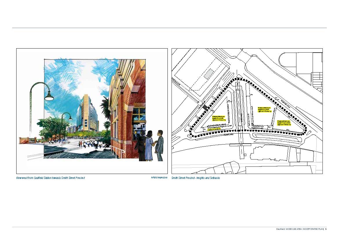
- The April 2011 version which became the official C60 and which was never given to residents prior to the formal consultation process, and
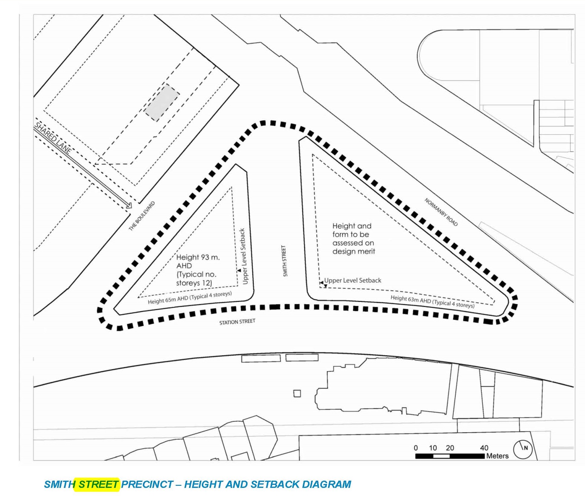
- The latest 2013 version which is again different to one that was extant several months previously (ie also in 2013)
- Readers need to take careful note of the differences in ‘preferred heights’ from both documents.
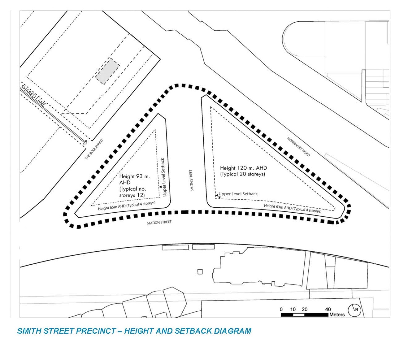
Here’s an even earlier version that again shows the not so gradual creep of these plans and Council’s acceptance of these. In July 2008 we were told 15 storeys –
 What is even more farcical is that when we compare council’s own comments on the first MRC proposal for a Priority Development Zone/Amendment C60 (minutes of 4th September 2007) we find that nothing much has changed and that council’s comments then are still valid for the latest version of the Development Plan. We quote –
(k) The MRC envisages the amendment facilitating office development of 20,000 sq.m, retailing of 10,000 sq. m (including 4,500sqm supermarket) and cafes of 5,000 sq.m for a total of 35,000sq.m. This makes it three times the size of the Glen Huntly shopping centre, with less planning control than for a simple dual occupancy.
(l) It is also important to note, however, that the actual floor areas proposed are not articulated anywhere in the amendment documentation and have only been referred to obliquely in various technical reports supporting the draft masterplan lodged in November 2006. These floor areas have also been subject to change. For example, up to 10th August 2007 the office component of the development was quantified at 10,000sqm. On 10 August, Council was advised that it had increased to 20,000sqm.
Such (road) closures, however, will also be the subject of commercial negotiations with Council to ensure fair
return to ratepayers for Council-owned land.
(o) The amendment also proposes the downgrading of Station Street in order to provide on-street carparking, taxi ranks and access to the racecourse. In effect, this results in a discontinuance of this road in its current form. No
Road Closure Overlay, however, is being proposed to address this issue.
The most damning comment is –
This then becomes a problem of a flawed process. If the path of a priority Development Zone were to be followed, when the public has the opportunity to comment, there would be little to comment on; when details were available, there would be no opportunity to comment.
Readers should also keep in mind that the subsequent C60 Amendment is literally full of loop holes allowing the MRC in concert with Council to do whatever they like. It reads:
A development plan may be approved by the responsible authority:
with or without conditions relating to the use and/or development of the land;
which exceeds the preferred maximum heights or reduces the setbacks in the Preferred Maximum Height and Setback Diagrams in the Incorporated Plan; or which alters the Precinct Boundaries or the Staged Development Areas shown in the Precinct Plan of the Incorporated Plan and in this Schedule.
Given the history of this council’s acquiescence to the wishes of the MRC, and their failures to adequately consult and act in accordance with community wishes, the above clauses should be enough to set off many alarm bells for residents.

February 23, 2014 at 3:43 PM
The worst part in all this is that this area was a designated parkland owned by the crown. It somehow turned into Tabaret parking under Newtons watch and then gifted to the MRC for their disgusting development. One wonders which parkland is next. If only we had an independent audit committee or ombudsman to complain to!
February 23, 2014 at 5:24 PM
Complaints to the ombudsman are still warranted and these complaints extend far beyond Newton and reach right up to the Minister of both political persuasions and their departments. There has been a complete lack of transparency in every aspect of this. I suppose that the bottom line is that Newton cannot wait to get his hands on 2046 rates and the millions that this will reap enabling the cover ups for incomprehensible and incompetent previous financial decisions.
February 23, 2014 at 6:22 PM
I thought all Councils had to have an independent overseer of financial matters. Why cannot this council abide by its charter?
February 23, 2014 at 5:24 PM
Council gave everything to the MRC and didn’t even give residents an opportunity to review 2011 Incorporated Plan with increased heights and no analysis of any kind – thanks PIlling, Hyams, Esakoff and Lipshutz.
Boof!!! here you go MRC – we will blame it all on our trying to avoid the Minister calling it in.
Watch em use the same Minister Call In excuse on the Development Plans.
Council has the ability no to reject the development plans and thereby do what they should have done in the first place – conduct a proper consultation and conduct an analysis on the impacts on the surrounding residential areas.
The Minister won’t call this in in an election year (he got so much more to worry about) – time Council did its job.
February 23, 2014 at 6:25 PM
It will take a Ukranian like revolution before the gang and Newton gives up power in Glen Eira. There would have to be a lot of blood on the footsteps of town hall before Newton, Lipshuts, Hyams, Esakoff and Pilling would even think of releasing their grip of power.
February 23, 2014 at 6:52 PM
The original Tricky Dickie resigned in the face of almost certain impeachment and loss of office—and was then shamefully pardoned. Anyway, C60 comes under s37 of GEPS, and that entire section has been delegated to Council staff. While an eventual decision on the Development Plan is likely to go to Council, staff could make the decision under delegation. It appears that staff have already decided that the submitted Plan is satisfactory even though it isn’t generally in accordance with any of the variants of the Incorporated Plan [s37.06s02 6.0].
Sure, people can submit comments, but there is no obligation on the responsible authority to consider those comments when making a decision—they don’t form part of the decision guidelines. PAEA just says that submissions and objections must be considered before making a decision. Staff could read and reject all objections then write a report recommending approving the Development Plan to Council in which no flaw in the Plan is mentioned.
As should be now clear, C60 is a carefully stage-managed campaign, in which the size and composition of development has been incremently expanded over the years. It is likely that the promoters inside and outside of Council always intended it to be this big. The latest changes are designed to remove review rights from the residents whose amenity will be affected.
Another tricky thing is that the Incorporated Plan talks about heights using AHD [“sea level”]. The indicative storeys are bogus, and by going slightly subterranean extra storeys have been squeezed in. There is a presumption that the only thing residents care about is height too. Ultimately nobody knows how much money the existing residents will be obliged to spend to subsidise this development. Already drainage works are being done in the surrounding area at our expense to support the extra runoff from C60’s 100% non-permeability.
February 23, 2014 at 9:31 PM
My first thought was that the only consolation nearby residents have is that the MRC must soon run out of free hold land (ie. land they either bought from the proceeds of activities on crown land or land they were gifted as road closures). Then I realised that by some strange quirk Council has defined all the crown land north of grandstand as being in the infamous Phoenix Precinct – land designated to also serve the purposes of public park and recreation ground.
It’s pretty obvious the MRC and its Council cohorts stitched up the residents long ago and over the past 12 years been setting themselves up for the Caulfield Village whammie. Such a display of dogged determination (ably supported by Council) shows the master punch is yet to come – whether it will it’s the crown land between the grandstand and Station Street (probably the second whammie) or the Centre of the Racecourse (probably the third whammie) remains to be seen but it’s a pretty safe bet that it’s only a matter of time.
February 23, 2014 at 9:39 PM
Residents near the racecourse should tell Esakoff, Hyams, Lipshutz and Pilling to get f*cked.
I suppose the only thing thats stopping them doing so is that there are no applicants for the job.
February 23, 2014 at 10:51 PM
The Gang of Four are merely puppets to the Grand PooBah. All roads lead to Andrew Newton.
February 23, 2014 at 11:33 PM
Agreed – but there are even less applicants for that specific job
February 24, 2014 at 11:28 AM
Don’t know if I’m understanding this fully so anyone please tell me if I’m way off beam. Looking at the different versions of the diagrams makes me think that council has again sold out residents by removing any height limits that they reckon they’ve imposed a few years back. The mrc gets its first bit in and then down the track everything has changed and they can put in a development plan for 23 or 25 stories or whatever they like.
Another weird thing is at the bottom of the drawings theres a 2 metre difference for the setbacks and they are still saying that this is 4 stories for both. 2 metres is a lot and I can’t see how they can both be 4 stories unless they start digging underground or wack in smaller ceilings in one.
February 24, 2014 at 2:21 PM
Tricky Dicky is one way of seeing this. It lets council off the hook too easily. I’d call it collusion in making sure that the MRC gets exactly what it wants with no hindrances for any changes in the future. Like all developers they have to wait and see what the market can bear. If they’re drowned in applications we can be sure that dwellings will increase and commercial space too. In the meantime that same traffic management reports will be the “standard” and so will infrastructure. A saving there of what could be millions to further line the pockets of the MRC.
February 25, 2014 at 9:50 AM
The Redan Road bicycle lane installation smacks of collusion – everywhere else in the municipality installing bicycle lanes only involves painting a white line on either side of the road and adding some cycling symbols.
Not so Redan Road – it involved
– landscaped traffic calming treatments all along the street and which at one point reduce a wide four lane road to one lane
– a loss of about 15 on street parking spaces (a number of residences are single fronted Victorian/Edwardian that have limited on-site parking capacity and on-street parking is already in high demand) which was disputed by the Glen Eira/O’Brien Traffic Department who claimed only a loss 5)
– 93% of residents signed a petition against it – under the proposal several the landscaped traffic treatments would permanently prevent them from parking within 100 metres of their residence.
– Resident discussions with Ward Councillor/s and the Glen Eira/O’Brien Traffic Engineers proved several of the engineers claims blatantly wrong, described the cost of the installation as a waste of ratepayers money particularly as all residents wanted was a couple of speed humps and the cycling lanes.
– Residents and Councillor/s agreed the speed hump solution would be pursued.
– Residents have now been advised that at the last Councillor Assembly (despite the local law prohibits decisions being made in Assemblies) it was decided to implement the Glen Eira/O’Brien recommendation. No doubt the tactic of letting ward councillors off the hook on contentious issues by non-ward councillors (who have probably never seen the Road) out voting them on the basis of “greater good” for the community is once again being played.
Oh did I forget to mention
. Redan Road, North Caulfield, is an wide angled road (approx. 400 metres in length) that links Balaclava Road with Kambrook Road.
. The Balaclava junction is smack dab across from Caulfield Park next to the controlled Bambra and Balaclava Roads intersection.
. Kambrook Road end is smack dab opposite the MRC’s Caulfield Village’s main Kambrook Road pedestrian access point and that the MRC is going to undertake the installation of pedestrian safety treatments at the Kambrook Road/Redan Road intersection.
. That Redan Road residents do not have a major traffic volume/speed issue since the 40 k/h speed limit and combined the restricted left turn and pedestrian safety refuge (from Kambrook to Redan) was implemented in 2007/2008. Ditto with the Balaclava Road/Redan Road intersection.
. That the Caulfield Village Development Plans focus on Redan Road as a major pedestrian/cycling route to access Caulfield Park and a tram stop that is further away then the Kambrook/Balaclava tram stop.
. How lovely it would be for the Caulfield Village residents to stroll/cycle down a wide, landscaped, tree lined avenue on their way to the already “at capacity” Caulfield Park – not to mention a photo op for the Caulfield Village marketing materials.
No doubt the Redan Road residents are greatly consoled by the fact that their already Caulfield Village impacted amenity will be further reduced by unwanted traffic treatments, that will prevent them from parking near their residences and that are being partly funded from their rates.