At last council meeting this public question was asked –
At the May 19 meeting, Council agreed to provide a summary of outcomes of the final State Government’s Carnegie Activity Centre plan vs Council’s Structure Plan on Council’s website so changes would be clear to the Glen Eira community. With the release of the finalized plans for the Stage 2 Activity Centres last Friday, when will that Carnegie information be available and will Council provide similar detailed explanations for all the Stage 2 Activity Centres?
Answer:
Council placed an update to the Carnegie Structure Plan 2022-Amendment C237 webpage on 19th June 2026. This included information relating to the state led activity centre plan for Carnegie approved under Amendment C278. This update included changes to over shadowing controls between the two plans.
Now that the Stage 2 plans have been released, we will provide a more detailed summary of the differences between the State led activity centre plans and Council’s Structure Plans for Bentleigh, Caulfield and Glen Huntly by this Friday, 3 July. The state led plan for Elsternwick only refers to a range of heights associated with the Elsternwick Structure Plan. The plan does not illustrate how this height range is applied to different sites within the Elsternwick core. Therefore, a summary of the state led plan and Council’s plan for Elsternwick can only be prepared once further information is released by the State Government. To note, the final controls for Stage 2 activity centre plans are yet to be issued so there may be further changes Council is not currently aware of.
COMMENTS
We have repeatedly bemoaned the fact that this council is determined to keep its residents ignorant of the significance of changes made by the State Government and how these changes will impact all ratepayers across the municipality. When public questions have to be repeated ad nauseum, and the responses and ensuing actions fail to provide the information required then we conclude once again that the objective is to fully comply with whatever is handed down by government and to treat residents with disdain.
We have finally located the so called ‘summary’ referred to above and affecting Carnegie – buried deep within council’s website and unlike Bayside Council certainly not on the council’s home page. And instead of a detailed and comprehensive summary of what the changes actually mean, the only comment made is in relation to the new overshadowing requirements. Not a word about heights, setbacks, building separation, etc. Instead of patting themselves on the back that one overshadowing requirement has now become mandatory at the equinox, rather than the solstice, council totally ignores all the other important changes.
Here’s council’s interpretation of what truly informing residents means: Please also note the use of language and how deliberately misleading it is. For example: we are told that the government amendment C278 REPLICATES what council proposed with its original Carnegie structure plan. Dictionary definitions of the word tell us that ‘replicate’ means to ‘make an exact copy’. Nothing could be further from the truth in this instance!!!!!!!
Planning Scheme Amendment C278
The Minister for Planning has approved Amendment C278glen (Implementing the Carnegie Structure Plan) which replicates the proposed council-led Amendment C237glen.
Amendment C278glen implements the key strategic directions of the Carnegie Structure Plan 2022 as proposed by Amendment C237 but replaces the Design and Development Overlay Schedule 9 (DDO9) with Built Form Overlay Schedule 4 (BFO4). The new BFO4 has been applied to the commercial core of the Carnegie Activity Centre. This change to replace a DDO with a BFO was made by the Department of Transport and Planning (DTP) to give effect to the State Government’s Train and Tram Zone Activity Centres Program.
The BFO was developed by DTP as part of their Activity Centres Program to provide opportunities to streamline planning assessments and support housing growth in and around activity centres.
The Amendment approved by the Minister implements the Carnegie Structure Plan 2022 in relation to the main commercial core area. The surrounding residential was rezoned to HCTZ under the Activity Centres Program and does not form part of this Amendment.
Amendment C278 deletes the existing Design and Development Overlay (replaced by the BFO) and also makes consequential changes to local policy within the Glen Eira Scheme.
Some notable changes to the council adopted version of Amendment C237glen made by Amendment C278glen include:
- Appling mandatory equinox overshadowing controls to the Woorayl Street Reserve rather than mandatory winter solstice controls. (noting that the independent planning panel had recommended applying a discretionary equinox control rather than the mandatory winter solstice Council was originally seeking). The final decision to apply the mandatory equinox control is considered a reasonable outcome.
- Amend the wording to clarify that the overshadowing requirement for the active recreation space below the Skyrail immediately west of Koornang Road is a discretionary equinox control applying between 10am–2pm.
Nothing in the above can or should be seen as an accurate summation of what has changed!
Here are some changes not even mentioned in this so called ‘summary’.
- Building separation in one instance has gone from the original 9 metres to 6 metres for buildings over 28 metres
- Setbacks that were previously mandatory for the heritage sites are now discretionary
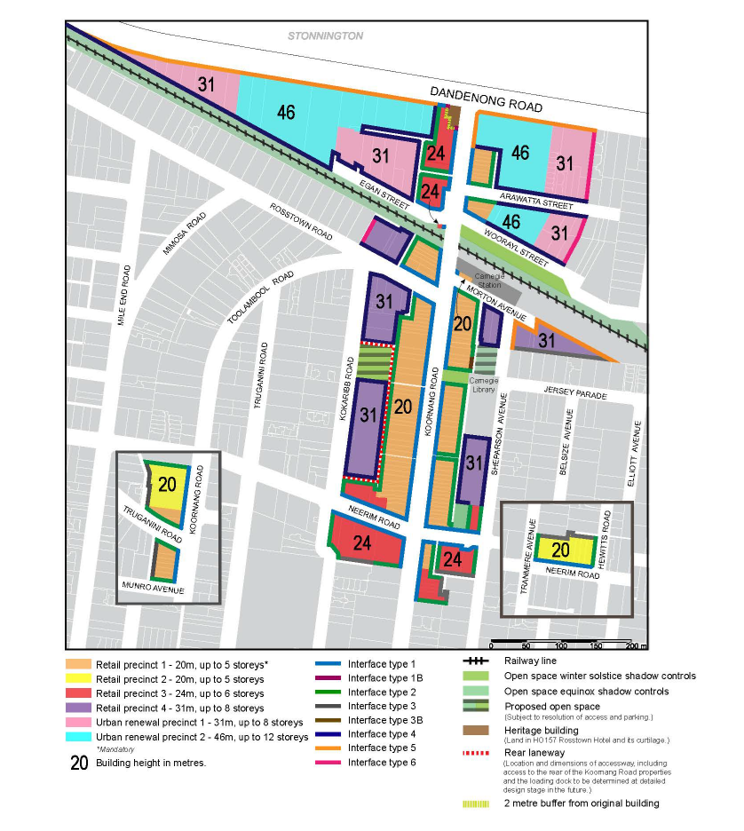
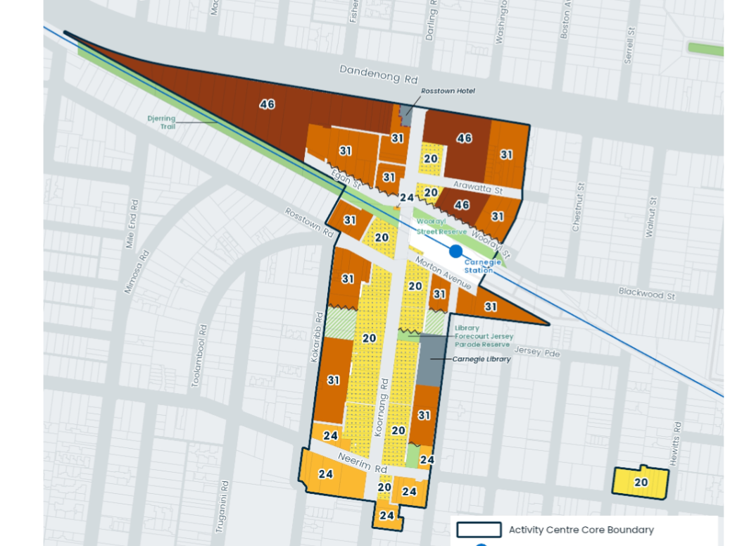
- Building heights in several locations have gone from 31 metres to 46 metres
Until we get an honest council that is fully committed to its residents and properly overseen by councillors nothing will change!
Finally, please compare the following two maps outlining heights. The first is from council’s structure plan and the second the government change –


July 3, 2026 at 2:00 PM
Heritage has mandatory height controls. Everything else is discretionary. That’s what council wanted and that’s what we have got. 12 stories could become 14, 15 or even more as recent events have shown. We’re going backwards at a great rate.
July 3, 2026 at 5:18 PM
Planning has become trapped in a cycle where yesterday’s mistakes are used to justify today’s. It is as though the solution to poor planning is simply more of it.
Instead of learning from mistakes such as congested roads, piles of dumped rubbish normalised as part of our street scapes, in some areas inadequate public transport, death of a 1000 cuts for green space and overstretched infrastructure, the planners mindless response is always the same, intensify the same model of over-development.
There is an alternative. Planning should start with infrastructure, environmental limits and community needs, not developer demand. Housing is essential, but creating liveable communities should be the objective, not an afterthought.
July 4, 2026 at 10:57 AM
Noticed another change along Koornang road. It’s now gone from 24 metres to 31 metres. Not bad. That’s another 2 or 3 storey increase in height.
July 4, 2026 at 4:27 PM
The Development Industry is notoriously corrupt, involving as it does large sums of money from one subfaction to another in return for influencing policy. The current plans ignore the alleged purposes of Planning Scheme, but Planning Schemes themselves have repeatedly been tinkered with corruptly. Problems start with the State Government and Planning Minister. They bypass scrutiny, make political decisions rather than ones based on merit, unevenly distribute all the problems that come from high-density development.
Some specific comments/issues:
Panels are only “independent” in the sense the content of their reports can’t be dictated by the minister, but continued presence on a panel is dependent on whether they are “sound” in a Yes Minister sense.
“Council” means multiple things. Legally its the councillors in a council meeting, but in practice and under LGA, the real power lies with the CEO and staff. The role of councillors is one of spokespeople. Anything that “Council” says should not be taken as resembling the truth until it can be independently verified.
Planning Schemes used to identify all sorts of issues requiring “Future Work”, eg drainage capacity to support the increased runoff from the 90% site coverage the Development Industry demands. Carparking and reliance on on-street parking is another. Every Council policy document and strategic plan gets replaced by a later one without assessment of what was achieved. Instead, out come new targets with new deadlines and no accountability.
The High Density development that Council and State Government is so keen on is more expensive per square metre than Mid-Density.
The State Government recognised that High Density development was not popular, so it introduced the notorious GRZ and RGZ zones, along with significant changes to MUZ. It was to appease the majority of voters by targeting development such that only a minority of voters were directly impacted. That is not how representative democracy is supposed to work.
One can look at the area around the primary railway station in Jacinta Allan’s own electorate to see that she doesn’t want for her community what her government is imposing on parts of Glen Eira. It is not to GECC’s credit that it has been so supportive of the Development Industry, which includes waiving compliance with Standards. Even Discretionary Standards deserve some sort of accountability about why and when they can be ignored.
July 4, 2026 at 5:39 PM
Will Council have copies in the Glen Eira Libraries ? as its hard to compare the computer maps above. I only have a black and white Printer
July 5, 2026 at 10:16 AM
We doubt that our libraries would have these documents and/or simply the images However, if you search the 2024 records of council meetings, the structure plan would be found in the agenda items. Check out the 23rd July 2024. The full amendment is listed there, including the various maps. For the government amendments you need to search for Amendment C278glen. That will take you to the full amendment. The uploaded images we’ve presented come from both of these documents.
July 5, 2026 at 10:24 AM
Don’t worry about colours. Look at the numbers in each map. They tell you the heights in metres. Compare them and you will see that there are some important differences. The government has increased heights in 3 areas and by a pretty big margin.