

CLICK ON IMAGES TO ENLARGE
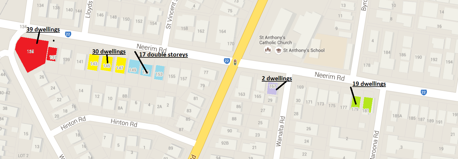
Above are 4 screen dumps of Neerim Road and what has been happening since the introduction of the zones. Each image represents a continuous stretch of road. Different colours are used for each application and indicate whether the proposed development extends over a single or ‘consolidated’ site. The numbers are for permits already granted or awaiting decision.
What is completely mind boggling is that the total number of apartments to be built along this single road since 2013 equals 548. Unbelievable! Thus, if 225 dwellings are built per year, then this represents more than 50% of what the planning scheme says is the average number of dwellings required per year until 2021! And all in one street!
How can a council allow this to happen? What studies have been done of ‘capacity’? Do they know? Do they even care? How much money will ratepayers have to fork out to supply additional drainage and other infrastructure? How much has already been spent on drainage and how much more needs to be spent? Has Council any idea or is this more pie in the sky planning based on no factual data and analysis? What guarantee do Carnegie residents have that they will not be at increased risk of flooding or that subterranean car parks will ultimately impact on the water table causing other major problems? In our view, Council’s incompetence is only exceeded by its indifference to its residents.
Here’s the full list of what’s presented in the images –
135-137 Neerim Road GLEN HUNTLY VIC 3163 – 3 storey, 39 dwellings
143-147 Neerim Road GLEN HUNTLY VIC 3163 – 3 storey, 30 dwellings
149-153 Neerim Road & 4 Hinton Road GLEN HUNTLY VIC 3163 – 17 double storeys
167 Neerim Road CARNEGIE VIC 3163 – 2 dwellings
179 – 181 Neerim Road, CARNEGIE VIC 3163 – 3 storey 19 dwellings
212 Neerim Road CARNEGIE VIC 3163 – additional dwelling to rear
247-251 Neerim Road CARNEGIE VIC 3163 – 4 storey, 48 dwellings
253-255 Neerim Road CARNEGIE VIC 3163 – 4 storey 30 dwellings
257 Neerim Road CARNEGIE VIC 3163 – 3 storey, 7 dwellings
259-261 Neerim Road CARNEGIE VIC 3163 – 4 storey 28 dwellings
276-280 Neerim Road CARNEGIE VIC 3163 – 5 storey, 48 dwellings
315-317 Neerim Road CARNEGIE VIC 3163 – 7 storey, 26 dwellings
322-326 Neerim Road CARNEGIE VIC 3163 – 4 storey, 40 dwellings
328-330 Neerim Road CARNEGIE VIC 3163 – 4 storey 16 dwellings
332-334 Neerim Road CARNEGIE VIC 3163 – 4 storey 36 dwellings
339-341 Neerim Road & 19-21 Belsize Avenue CARNEGIE VIC 3163 – 4 storey, 52 dwellings
363R Neerim Road CARNEGIE VIC 3163 – 3 storey, 4 dwellings
331-333 Neerim Road CARNEGIE VIC 3163 – 4 storey, 26 dwellings
365-367 Neerim Road CARNEGIE VIC 3163 – 3 storey, 16 dwellings
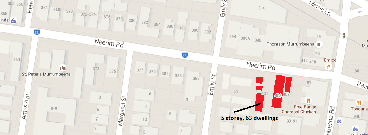
401-407 Neerim Road CARNEGIE VIC 3163 – 5 storey, 63 dwellings
479 Neerim Road MURRUMBEENA VIC 3163 – 2 double storeys
TOTAL = 548 DWELLINGS AND THIS DOES NOT TAKE INTO ACCOUNT WHAT IS HAPPENING IN ALL THE LOCAL STREETS RUNNING OFF NEERIM ROAD – IE ELLIOTT AVENUE FOR EXAMPLE!

November 12, 2015 at 8:40 AM
The third image is the worst by far. I did a rough count and there were about 45 properties fronting Neerim Road. Now there are going to be 216 new properties in this small area alone. That’s 5 times more apartments and at least 3 or 4 times more people and more cars on a narrow part of the road.
November 12, 2015 at 8:55 AM
The bagman is is now driving a new Porche
November 12, 2015 at 10:33 AM
The equivalent of new suburbs are being created with no thought given to infrastructure needs, parking needs, open space needs, and school needs and Carnegie is bearing the brunt of this get rich quick scheme.
November 12, 2015 at 11:33 AM
There’s more to come – http://www.theaustralian.com.au/business/property/vic-site-sale-568-neerim-road-and-34-poath-road-hughesdale/story-fnitinnf-1227449761526
http://www.commercialrealestate.com.au/property/360-neerim-road-carnegie-vic-3163-2012333864
November 12, 2015 at 12:57 PM
I knew it was bad but not this bad.
November 12, 2015 at 4:12 PM
Bloody disgraceful and complete overkill. Very sad indeed.
November 12, 2015 at 4:14 PM
Seeing the future laid out like this is very disturbing. I would think that hundreds more are going into all the surrounding sites and quiet local streets.
November 12, 2015 at 4:37 PM
FYI – The planning minister has today approved the Whitehorse Amendment which creates 5 new Neigbourhood Residential Zone schedules.
Here is a summary of what residents in these areas in Whitehorse can expect. We remind readers that in Glen Eira there is only a 50% site coverage and 25% permeability required in neighbourhood residential zones. Thus, isn’t it amazing what other councils can achieve?!!!!!
This amendment is required to implement the findings of the Whitehorse Neighbourhood Character Study 2014 and the Whitehorse Housing Strategy 2014. The new residential zones were implemented via Amendment C160 to the Whitehorse Planning Scheme. The Neighbourhood Residential Zone has been applied to residential areas proposed for limited change, and the introduction of schedules through this amendment will provide more
detailed guidance for built form in those areas
NRZ1/2/3/4 – site coverage 40%; permeability – 40%
Provision of at least two canopy trees per dwelling
that have the potential of reaching a minimum mature
height of 12 metres. At least one of those trees should
be in the secluded private open space of the dwelling.
The species of canopy trees should be native,
preferably indigenous
No walls to be constructed on boundaries.
A dwelling should have private open space consisting
of an area of 80 square metres or 20 per cent of the
area of the lot, whichever is the lesser, but not less
than 40 square metres. At least one part of the private
open space should consist of secluded private open
space with a minimum area of 35 square metres and
a minimum dimension of 5 metres and convenient
access from a living room. It cannot include a balcony
or roof top terrace.
NRZ5 – site coverage 50%; permeability 30%;
Street setback – Any new wall on a boundary should be setback at
least 10 metres from the front boundary or 1 metre
further than the average set back of the buildings on
adjoining allotments, whichever is the lesser.
November 12, 2015 at 4:44 PM
PS – we forgot to mention the Manningham amendment which states –
The Amendment applies to land within five local catchments in the City of Manningham which have been identified by Melbourne Water and Council as being liable to inundation in a 1 in 100 year storm event. The land affected is shown on the proposed planning scheme maps that form part of this amendment
In Glen Eira, ‘flood mitigation’ according to council has been ‘put on hold’!!!!!!
November 12, 2015 at 7:26 PM
Whitehorse has achieved its amendment I daresay because that council did some hard yakka research, crossing all the t’s and dotting all the i’s and presenting some quantifiable and well founded research. That is where Newton’s mob will fall flat on their faces – even if there was the will to change a few things. There is no recent research, no consultation, and I doubt their ability in doing anything that is likely to win government support. Instead of spending money on propaganda and spin, or more car parks in parks, this council should hire the best planners so that they do the work and residents benefit.
November 12, 2015 at 8:41 PM
There is going to be an almighty glut. Of 548 how many will stand empty? The bottom will drop out of the market and all that will be left are places that will rot because they are cheap and nasty.
November 12, 2015 at 9:19 PM
http://www.heraldsun.com.au/leader/inner-south/vcat-rejects-plan-for-apartment-block-in-mckinnon-culdesac/news-story/cab72d1ccca126263699195f4bc59607
magees living on another planet
November 12, 2015 at 10:09 PM
All this mess is the result of poor leadership from the staff. Good thing the CEO is leaving. Going to be a big mess for the next person to clean up. The quality of all this housing is extremely poor.
November 13, 2015 at 10:07 AM
Correction all this a result of totally negligent and incompetent leadership from Councillors who have decided, that rather than acting in accordance with their legal responsibility as head of Council and representatives of the ratepayers, to leave everything in the hands of the Administration without any oversight on their part..
Thus as a direct consequence of the above, rather than representing residents their role becomes one of protecting the Administration from ratepayers.
November 13, 2015 at 1:22 PM
This whole area has come under massive developer attack. Absolutely shocking and irreversable. The transport infrastructure simply will not cope.