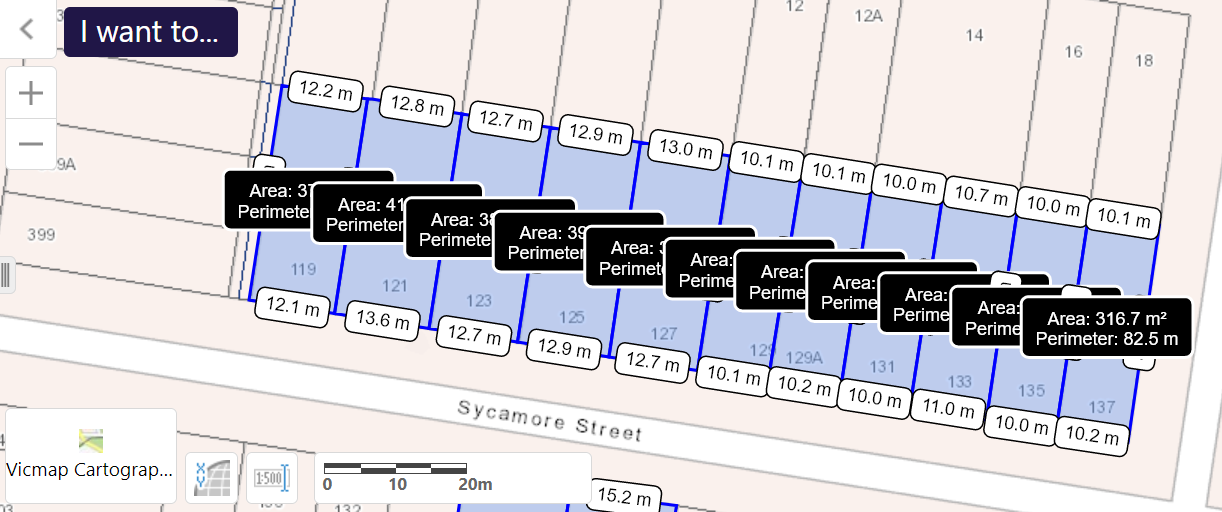
Council has stated that its intention is to create a new zone – NRZ2. The stated criteria for earmarking these areas are supposed to be sites along major roads/transport and that they are at a minimum 600 square metres in size. We have previously highlighted that there are countless streets that are not within coo-ee of such measurements. Here is another example – Sycamore Street in Caulfield.
Please note that there is only ONE SITE in the following image that is over 400 square metres. All of the rest are 300+ square metres – half of the size ‘recommended’ in the housing strategy. This leads to some basic questions:
- What on earth is this planning department doing? Have they actually bothered to investigate the sizes of the various streets earmarked for increased intensity? Or have they merely sat at a computer and drawn lines around various streets and properties?
- How can they produce criteria and then simply ignore them?
- Is this simply incompetence, or a total indifference to the basic rules of planning?
PS: here’s some more – Beech Street, Caulfield South.
All of the sites in this image are barely over 300 square metres, yet they are designated to become NRZ2 which means increased site coverage, reduced permeability, etc. In the attempt to make the measurements clearer, we’ve left off some sites, but their width and length is similar to those depicted. They will also be just over 300 square metres.

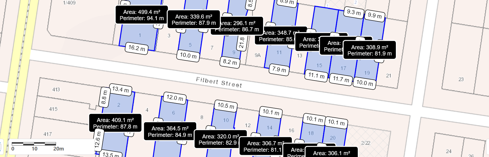
PPS – and Filbert Street, Caulfield South. Please note: not one site over 500 square metres and the vast majority just over 300 square metres.

November 15, 2022 at 11:28 AM
We don’t have a planning department. We’ve got a destruction department.
November 15, 2022 at 2:03 PM
Basic research hasn’t been done by Torres and his crew. The right hand doesn’t know what the left hand is doing half of the time. Three hundred odd square metres will never have 3 townhouses built, but they could have apartments with 3, 4, or even 5 dwellings. Council has no control over what is built. They’ve said as much. That means that all of these lines on some map are meaningless and there only to entice developers to come in some more. It is outrageous that the planning depart can continue to get away with such poor strategic planning and no one is held to account, or better still, fired.
November 15, 2022 at 3:32 PM
State Government is calling for higher density housing so why on earth is council trying to go in the opposite direction. Torres has lost plot and CEO is not pulling him in to follow well publicized State Govt directives….just wasting public money and not doing the numbers in the area.
November 15, 2022 at 4:17 PM
No brains in that whole damned place. Just a bunch of clowns sitting back and making it all up. To what end, and who benefits.
I suppose if these were just random errors it should come in the realm of 50/50 or so, give or take. Not so as it always favour their developer mates. There is room for a lot of speculation here, and there shouldn’t be.
It’s like that add on TV said “Oils ain’t oils Sol”.
In Glen Eira it’s “planning ain’t planning Sol”
It makes me wonder what it could be?.
November 15, 2022 at 5:25 PM
Dare I ask the question: Are some people in high places within this council ON THE TAKE. Too many unjustified dodgy decisions. What the hell are the councillors doing, they seem to either not care, or have no power. Maybe this council should be sacked along with certain departments so that proper planning controls on a logical basis can be applied at Glen Eira.