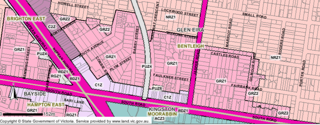
Moorabbin has been designated as a Major Activity Centre and encompasses Glen Eira, Kingston and also parts of Bayside. The Glen Eira area is north of South Road. Prior to early 2025, the zoning for this area was GRZ1 – ie mandatory 3 storey height limit. The areas further north were all NRZ – ie 2 storey height limit as shown in the following image.
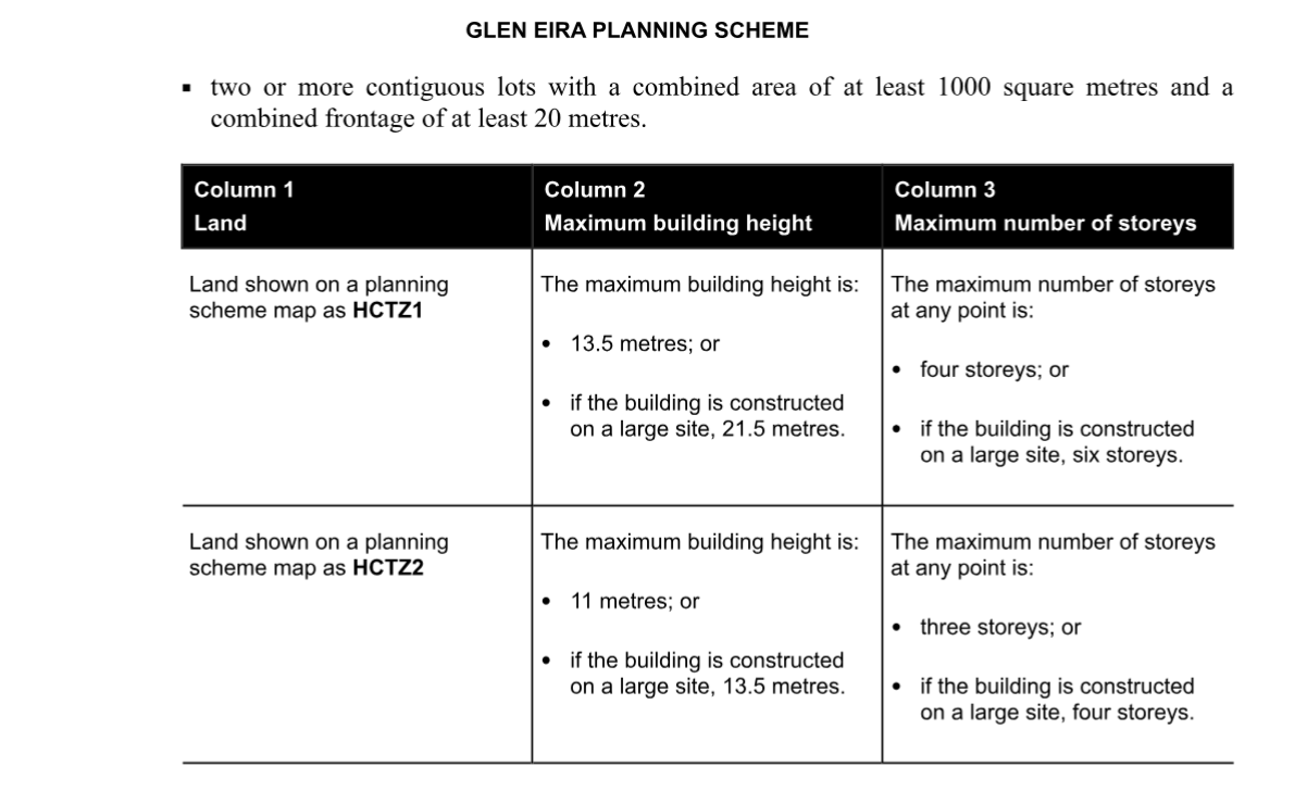
The government then introduced HCT zonings which were defined as follows:
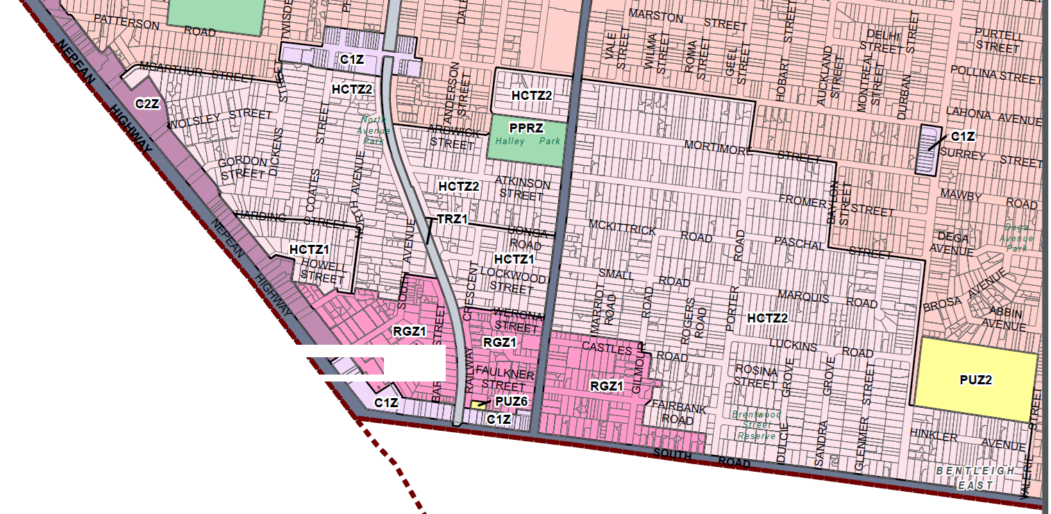
The result of these government amendments is an increase in height limits over a huge area. The GRZ zoning has now become RGZ (ie four storeys) and what was the NRZ zoning can now see three storeys on normal sites and four on large sites. This is shown in the image below.
The rationale for these changes is that catchment areas are supposed to be 800 metres from the core of the various activity centres. As the crow flies, this may be so. However, residents cannot fly and for them to walk to the core would be far more than 800 metres and certainly more than a 10 minute walk depending where they are coming from. This reminds us of council’s introduction of the residential zoning in 2013, when circles were simply drawn on the map with no consideration of which areas are heritage, which are in flood zones, and which are large sites. This is not planning. All it does it provide more and more land for overdevelopment and the destruction of residential amenity.
Council did submit their submission on the proposed introduction of the new zoning and Built Form Overlays in October 2025. It was a pretty dismal response to what was being mooted. Here are some quotes from this submission. Make up your own mind as to how well council represented resident views via such comments.
Council’s experience with the deemed to comply approach in the Moorabbin and Chadstone activity centres, is that Council is limited in its ability to encourage increased development within the catchment areas, where appropriate. This is due to the changes which essentially switch off policy and zone purpose considerations for townhouse development. The intent of the catchments is therefore not being achieved in these existing locations and Council is likely to see a similar result in the Carnegie Cluster unless changes are made to the planning controls.
Directing housing into existing activity centres will reduce the impacts of significant growth on the environment in growth areas. Living more closely together can open opportunities for the sharing economy, increase local services and reduce the need for travel, and enable more people to live close to public transport

March 28, 2026 at 10:30 AM
This area is at significant risk of becoming an unhealthy environment for residents due to the cumulative impacts of traffic, pollution, and inadequate urban design controls.
South Road already functions as a major traffic corridor, a condition that has intensified following the opening of the Dingley Bypass. It now carries sustained volumes of heavy vehicles, particularly diesel trucks, contributing to consistently elevated levels of air and noise pollution. The presence of frequent signalised intersections further exacerbates this issue through prolonged vehicle idling, increasing localised emissions exposure.
This context is compounded by broader policy settings. During the recent energy supply pressures, the Federal Government permitted lower-grade automotive fuels to be sold which are associated with higher emissions. In high-traffic environments such as this, the effect is magnified, placing additional strain on already compromised air quality.
While current planning policy promotes increased density in activity centres and transport corridors, the lived experience of such development when not matched by infrastructure and design quality will diverge significantly from stated policy intent. In this instance, there is a clear risk that increased density will occur without the necessary supporting conditions, resulting in adverse social or community care outcomes.
These include overdevelopment without commensurate amenity, increased traffic congestion, erosion of neighbourhood character, and heightened environmental stress possibly leading to mental stress outcomes. collectively, these factors diminish liveability and undermine community confidence in the planning framework.
Critically, the determinants of a healthy urban environment are not aspirational but practical. Effective outcomes rely on the provision of substantial tree canopy and vegetated buffers to mitigate air and noise pollution and contact with the natuarl world, appropriate building setbacks to reduce exposure, and traffic management strategies that prioritise flow and minimise idling.
In the absence of these measures, the likely outcome is the creation of an “unhealthy zone,” irrespective of the stated objectives of the planning controls.
Accordingly, any increase in density within this area must be contingent upon demonstrable and enforceable commitments to urban greening, higher built form standards, and traffic mitigation. Without these, the proposal risks delivering a materially degraded living environment.