What is the future for ‘Moorabbin’ likely to be? We have used inverted commas, since council’s plans for ‘Moorabbin’ are really plans for Bentleigh! Moorabbin as such, is in Kingston and not Glen Eira! Admittedly Plan Melbourne has nominated ‘Moorabbin’ as a Major Activity Centre. The borders of this ‘activity centre’ are not identified in Plan Melbourne and everything has been left up to local councils.
The rail station is in Kingston. There is a structure plan already in existence by Kingston where their side of South Road and Nepean Highway is divided up into a number of precincts. The tallest buildings will be 7 storeys, mainly along Nepean Highway and one fronting South Road. All the rest according to the structure plan will be 3 and 4 storeys.
We can only speculate what Glen Eira has in mind, but it behoves residents to consider the following and its implications:
- Moorabbin (aka Bentleigh) has been allocated the prize of a Major Activity Centre with ‘opportunities for urban renewal’
- It is thus upgraded from a Neighbourhood Centre
- It also includes ‘major focus for housing growth opportunities’
Given that ‘urban renewal’ means the potential for 12 storeys in Glen Eira terminology, is this the future set down for this area? And if not 12 storeys, then how high? – 7 storeys? 8 storeys?
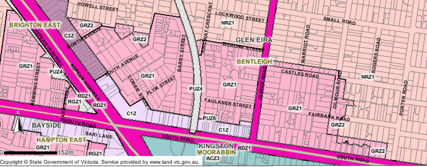
Below is the current zoning for this proposed new Major Activity Centre. Please note that surrounding the commercial area, the zoning is mainly GRZ1 – ie 3 storeys.
We speculate that the following is likely to occur –
- Three storeys up against 7 or 8 or 9 that will become the ‘urban renewal sites’ is not feasible. That would mean that many of the streets surrounding the commercial zones will also have to be ‘upgraded’ – ie to 4 storeys or even higher. You wouldn’t want 3 storeys sitting alongside even 6 storeys!
- Since the borders are also likely to be expanded, it would not surprise if the GRZ zone was expanded into the current Neighbourhood Residential zones.
We admit this is all speculation. However, knowing how our council has operated throughout this entire process, nothing would come as a surprise. If we are wrong, then all council has to do is be upfront and deny categorically that this is what they are planning! Silence of course can only be interpreted as ‘consent’!!!!!

December 12, 2017 at 11:33 AM
C2 will be changed to c1 for residential. It will then mean all of Nepean highway will be highrise plus joining up with the Bentleigh zones down from Patterson road.
December 12, 2017 at 6:06 PM
That’s just the start
December 12, 2017 at 3:10 PM
Well, it certainly needs a facelift down there and difficult to argue that there aren’t some parts of it suitable for major development and major change. The transitional aspect is of course a challenge.
December 12, 2017 at 3:58 PM
Council doesn’t have a cohesive set of principles for development, and what principles it has, it doesn’t apply consistently. It is hard to fathom what Council might choose to impose on the affected residents. Elsewhere in the municipality we know it means more noise, loss of amenity, lack of diversity, extensive moonscaping, reduction of services.
Now that State Government and GECC has reached agreement that 12 storeys is about right for land previously zoned Industrial regardless of public transport, the obvious area to target is all the industrial land near South Rd and Warrigal Rd. Arterial roads are a major impediment for pedestrians but I doubt decision-makers will pay much attention to safety or convenience. There needs to be a wholesale change in community attitude to cars and on-street parking first.