The agenda for Tuesday night’s council meeting includes our first look at the draft Bentleigh Structure Plan. The recommendation is to put this document out for public consultation for a period of 6 weeks. We know little about the nature of this consultation, except that it will include: a range of in-person and online opportunities for the community to provide comments, feedback and ask questions. In other words, we anticipate another mock consultation that only achieves the ‘consult’ range rather than the ‘involve’ stage recommended in the IAPP2 ladder for public participation.
Far more depressing are the actual recommendations contained in this draft. A short summary follows:
- Discretionary heights of up to 8 storeys along Centre Road for non heritage buildings – which means developments could be even higher.
- Only heritage buildings to have a mandatory 5 storey height limit (17.8 Metres) along Centre road
- A discretionary 7 storey height directly abutting a two storey heritage overlay along Campbell and other streets
- The real possibility of a reduction in onsite care parking requirements
- No mandatory rear site setbacks for developments abutting residential/heritage
- Discretionary front setbacks for non heritage properties
- Potential sell-off of council owned land for mixed use development that might include social housing. Please remember that council’s policy as it stands only asks for a 5% component for large developments. Other councils have asked for as much as 20%!
- Winter solstice considerations only to be taken into account at a measurement of 3.9 metres from the site boundary in side/local streets. How many of these streets have footpaths that are a bare 2.5 metres in width?
Here’s a run down of the proposed heights. CLICK TO ENLARGE THE IMAGE
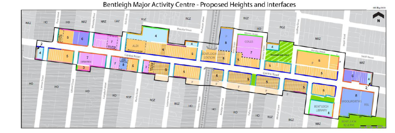
Readers should note the following:
- Only those hatched sites (ie with///////markings are heritage listed). Thus all other sites earmarked as 5 storeys could potentially be much higher.
- The number of residential properties that are currently in NRZ that will have a discretionary 7 or 8 storey building backing onto them – ie Wheatley Road, Campbell street, Smith Street, etc. Clearly a difference of 5 or 6 storeys does not matter to our council planners!
Finally, what’s not shown in the above map are the proposed future rezonings of the residential hinterland.
We urge all readers to carefully consider the published documents and to partake in the upcoming consultation.