We are committed to facilitating genuine debate within Glen Eira. Your views on planning, environment, open space, CEO and councillor performance matter.
The State Government has released more documents outlining its latest vision for the so called ‘transport zones’. What needs to be called out here in the strongest terms is the dishonesty that is encapsulated in these images and the spin that surrounds them.
Why dishonest? For starters, residents should expect:
Legends for each map that outlines in detail the building heights, the setback requirements, the controls that will apply to heritage areas.
Here is the image that shows what is happening to Carnegie, Murrumbeena, and Hughesdale. None of the above mentioned categories are provided with this image.
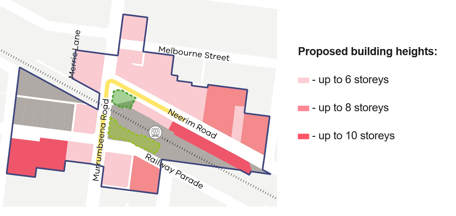
If we then take a closer look at Murrumbeena, from another document, we find the following –
Whilst height limits are included this time, there is no reference to what is happening in the inner and outer catchment areas, nor for our heritage sites. Referring back to the first image above, we can see how the dark and light blue areas have dramatically expanded. But we should not have to try and piece together information from different maps and still get no clear summary in one spot. That is dishonest and illustrates the attempt to obfuscate and make things as nebulous and difficult for the community as possible. This isn’t ‘information provision’ with the objective of truly informing communities. It is more of the same – spin designed to allay criticism and community revolt. Shame on this government and more shame on our council for not tackling these issues head on but resorting to simply regurgitating the government proposals with no summaries, no real criticism, and no attempt to truly inform residents.
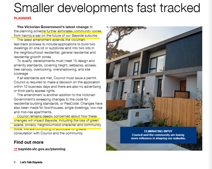
One simple example of this compliance by Glen Eira is evident in the following image from Bayside. Nothing has been said by Glen Eira on this issue. Most people wouldn’t even know that this has occurred. Yet Bayside in its official publication (akin to our Glen Eira News) can address this issue directly and provide real information and criticism.
Compare the above in both tone and content to what Glen Eira habitually produces! No detail, no real comments apart from how wonderful their earlier structure planning and housing strategies are, and then the final insult – go the Engage Victoria for further information!!! Woeful!
Why, oh why, are residents in Glen Eira treated like mushrooms that have to continually be kept in the dark? Why can other councils publish their most recent communications with government/departments with no qualms and in Glen Eira residents are left with no idea as to what is really going on.
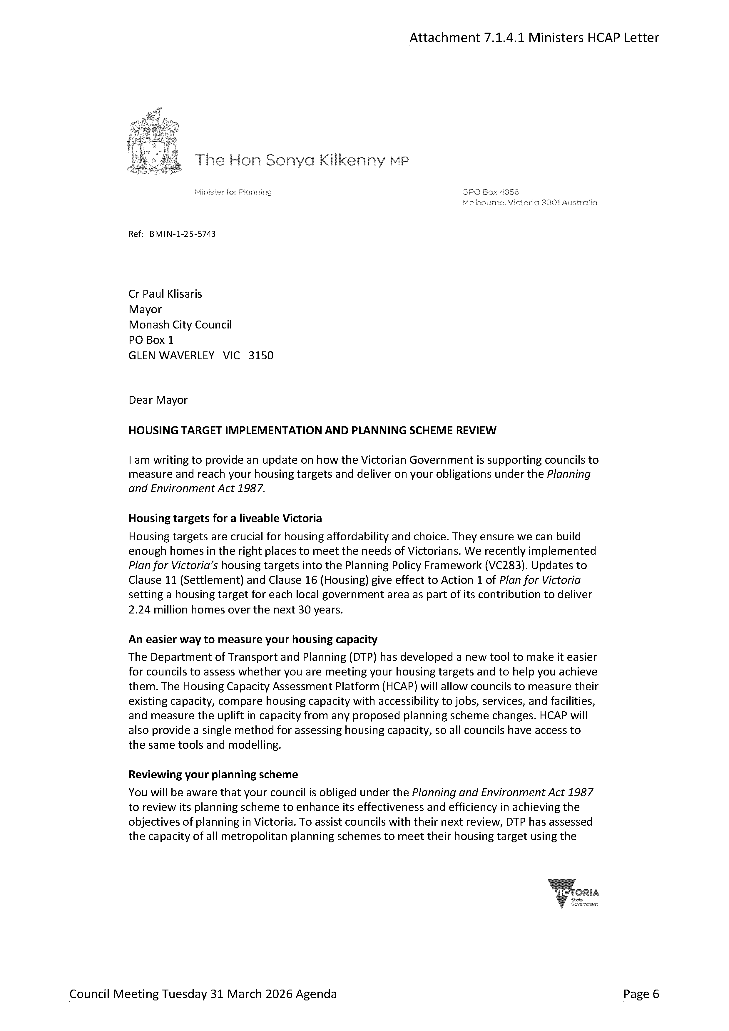
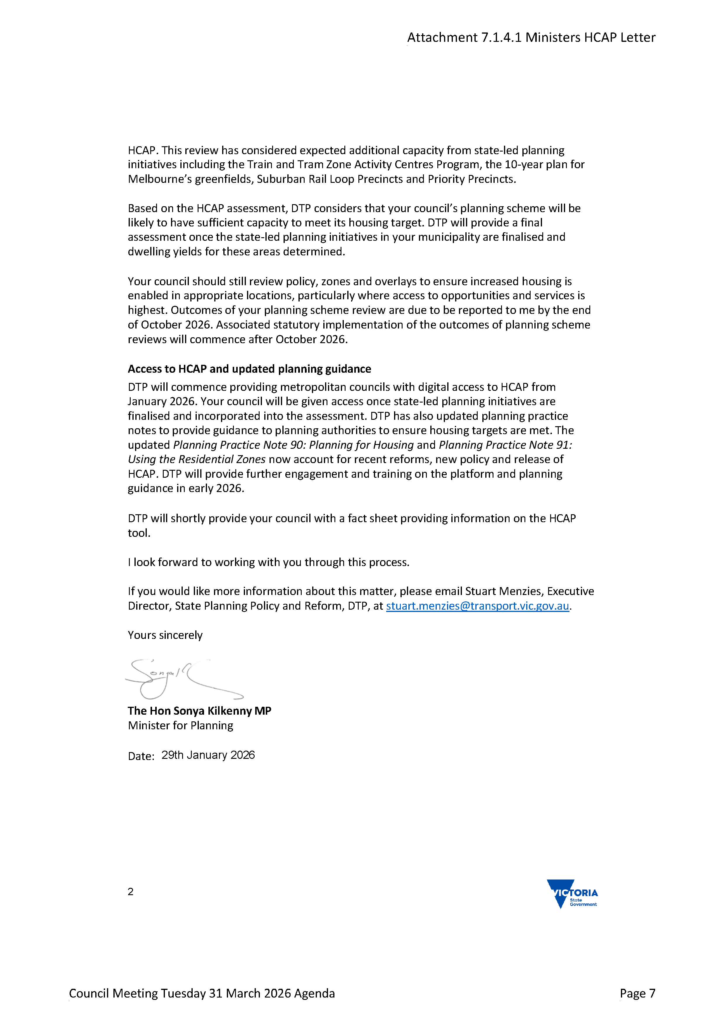
The latest example of this comes from Monash City Council, where we learn that in January this year, Kilkenny wrote to all councils informing them of a ‘tool’ that the government had developed in order to assess whether each council was meeting its dwelling targets. Even more interesting is the information that councils must undergo a full planning scheme review by late October 2026. Readers will remember that the last council review that incorporated full community consultation took place in 2016. That is literally a decade since the community has had any say as to how this planning scheme might work and/or what needs to be done. Since 2016, we have had ‘internal’ reviews that basically did nothing nor was any justification provided for some tiny changes.
As per usual questions abound –
Given that it is now nearly April, will council incorporate full community consultation on the mandated planning scheme review? If so, when will this start? If not, why not?
What preliminary conclusion has the state government made in regards to Glen Eira meeting its dwelling targets? Will council publish this information?
Will council publish the tool used to make this assessment and its rationale and methodology?
Will council commit to full and comprehensive reporting of its contacts with government and the department as other council do?
Are councillors provided with the hard copy communications between officers and government and/or department? If not, why not?
Below we publish the letter from Kilkenny that was sent to all councils. Please read carefully and consider the questions we have raised.
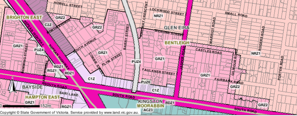
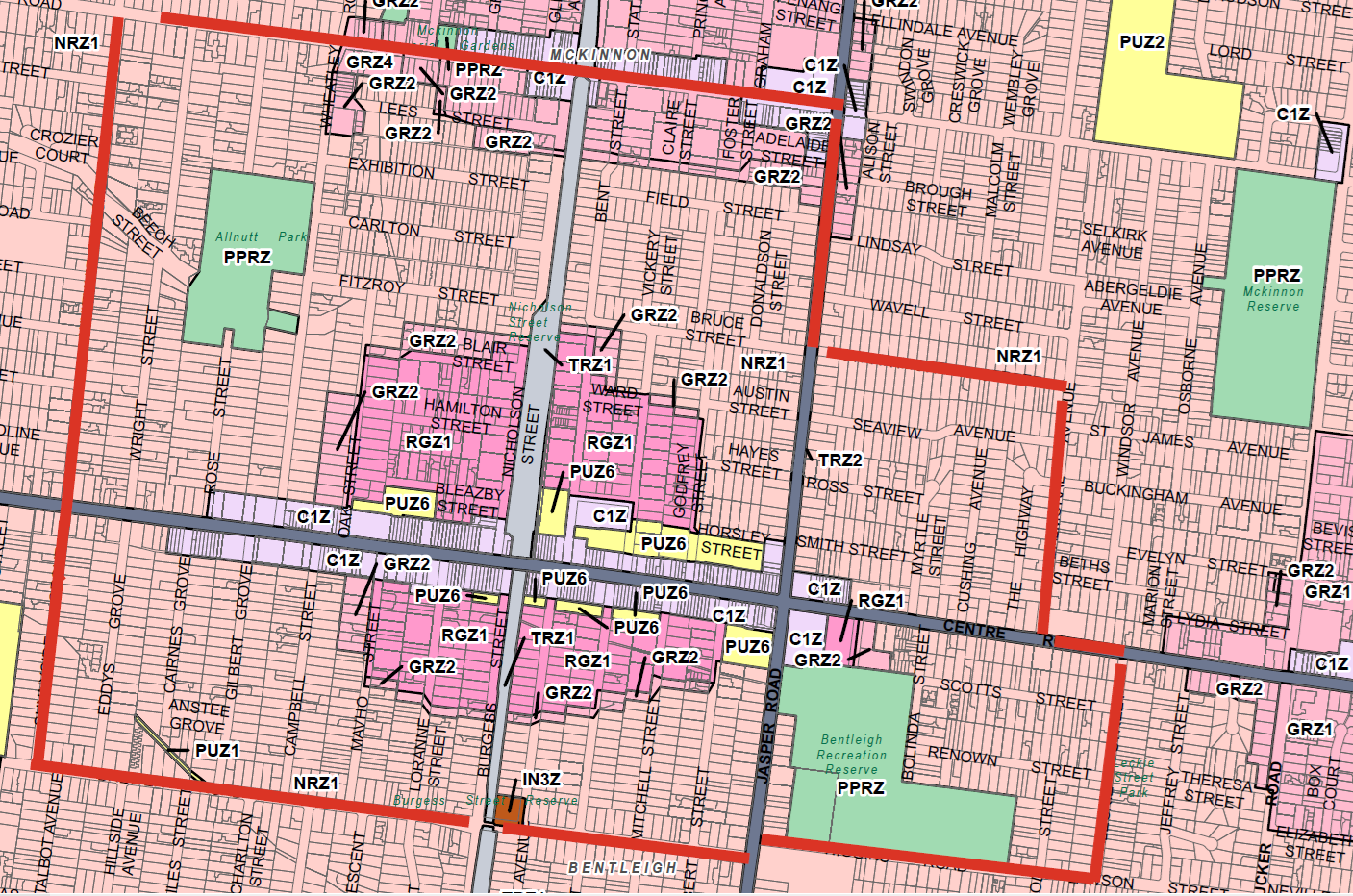
Moorabbin has been designated as a Major Activity Centre and encompasses Glen Eira, Kingston and also parts of Bayside. The Glen Eira area is north of South Road. Prior to early 2025, the zoning for this area was GRZ1 – ie mandatory 3 storey height limit. The areas further north were all NRZ – ie 2 storey height limit as shown in the following image.
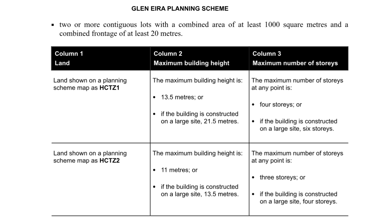
The government then introduced HCT zonings which were defined as follows:
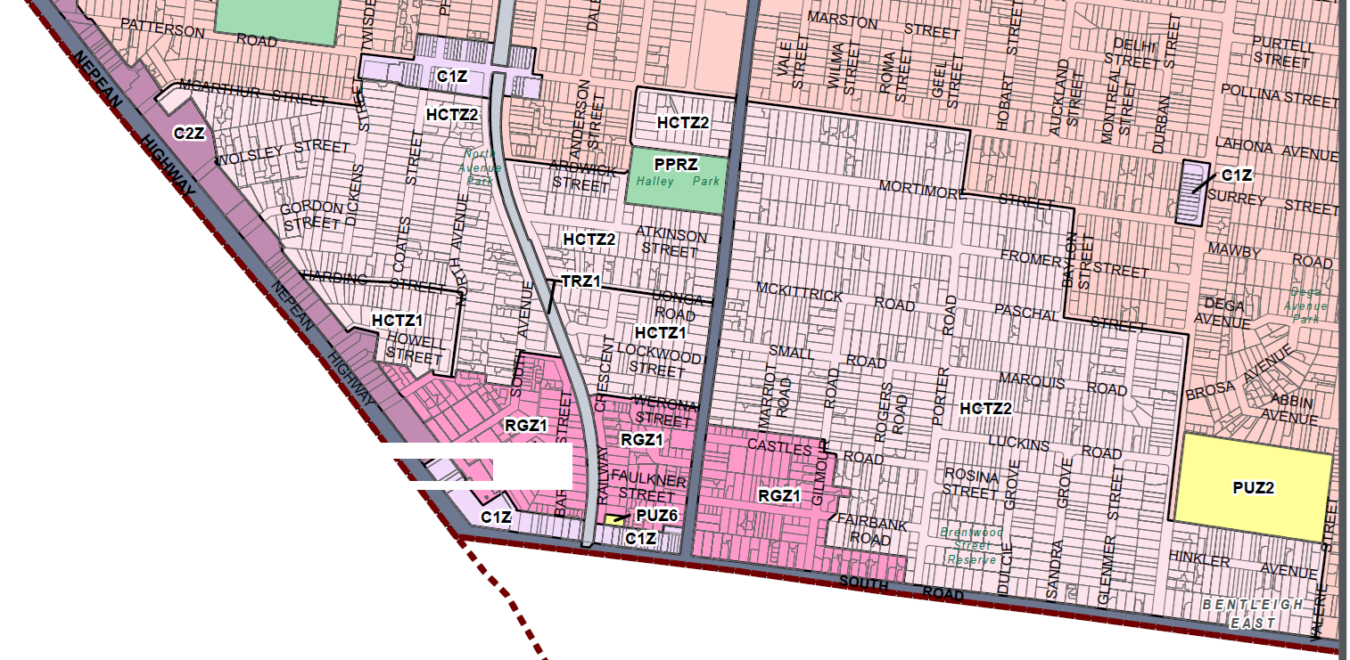
The result of these government amendments is an increase in height limits over a huge area. The GRZ zoning has now become RGZ (ie four storeys) and what was the NRZ zoning can now see three storeys on normal sites and four on large sites. This is shown in the image below.
The rationale for these changes is that catchment areas are supposed to be 800 metres from the core of the various activity centres. As the crow flies, this may be so. However, residents cannot fly and for them to walk to the core would be far more than 800 metres and certainly more than a 10 minute walk depending where they are coming from. This reminds us of council’s introduction of the residential zoning in 2013, when circles were simply drawn on the map with no consideration of which areas are heritage, which are in flood zones, and which are large sites. This is not planning. All it does it provide more and more land for overdevelopment and the destruction of residential amenity.
Council did submit their submission on the proposed introduction of the new zoning and Built Form Overlays in October 2025. It was a pretty dismal response to what was being mooted. Here are some quotes from this submission. Make up your own mind as to how well council represented resident views via such comments.
Council’s experience with the deemed to comply approach in the Moorabbin and Chadstone activity centres, is that Council is limited in its ability to encourage increased development within the catchment areas, where appropriate. This is due to the changes which essentially switch off policy and zone purpose considerations for townhouse development. The intent of the catchments is therefore not being achieved in these existing locations and Council is likely to see a similar result in the Carnegie Cluster unless changes are made to the planning controls.
Directing housing into existing activity centres will reduce the impacts of significant growth on the environment in growth areas. Living more closely together can open opportunities for the sharing economy, increase local services and reduce the need for travel, and enable more people to live close to public transport
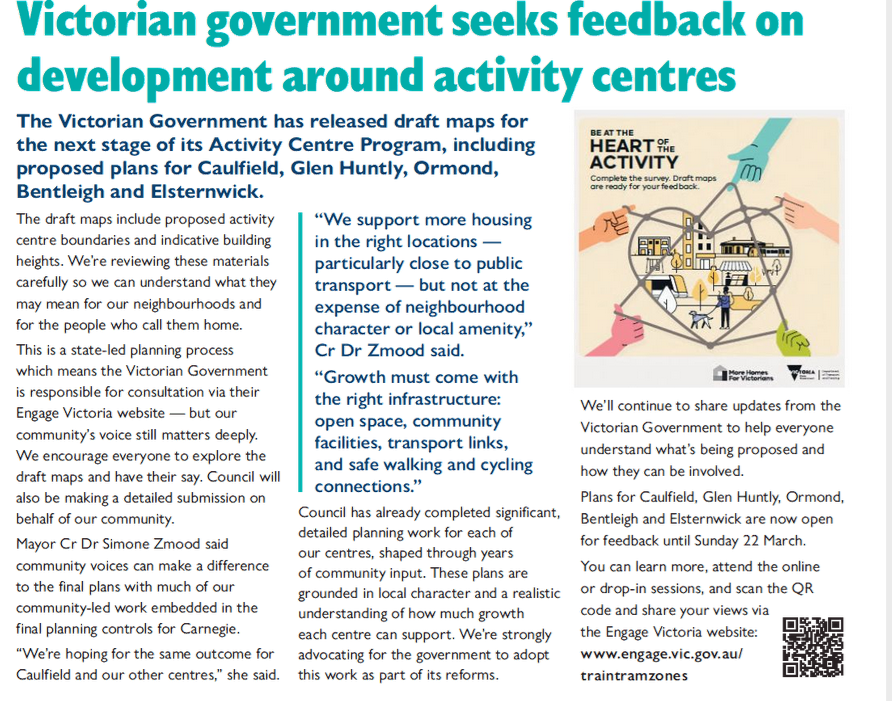
Over this last weekend, the State Government convened its Community Reference Groups ‘consultations’ over the proposed Stage 2 Activity Centre Program. As anticipated, this was nothing more than another ‘tick the box’ exercise in political gaslighting designed to evince ‘support’ for already made planning decisions.
For starters, attendees were told that they could NOT comment on anything to do with the CORE areas of the activity centres. Thus, proposed and contentious height limits were off the table. All that was open for ‘discussion’ were the nominated catchment areas. And even for these catchment areas, the focus was not on their extensive ‘upgrading’ or the evidence to support this.
Whether this state government actually listens to what was said (although unasked for) remains to be seen. But we certainly are not holding our breath for any major changes that accord with community and even council views.
As for Glen Eira, we are still awaiting its submission and its recommendations. Boroondara has published their version in a comprehensive and critical analyses. One of their main points is that a ‘one size fits all’ approach to the activity centres, as adopted by the government, is sheer folly. This point was also raised in the Glen Eira CRG over the weekend. How can you adequately plan for such diverse areas as Caulfield versus Bentleigh in terms of open space, infrastructure, sunlight in east west streets, versus north south running strips, when a one size fits all approach is adopted?
Below we feature some direct quotes from the Boroondara submission. We have included topic headings but the submission(s) also feature plenty more that we have omitted. Available at:
Council remains concerned and opposed to the continued use of generic precinct typologies to determine future development outcomes and for the structuring of the BFO (Built Form Overlay) schedule in the commercial core in Ashburton.
As noted in Council’s Phase 2 submission for Stage 1 Centres, Council considers the typology approach is flawed. It misses opportunities to deliver viable, localised urban outcomes – something the Victorian Government should strive for. It is a backward looking methodology which emphasises simplification at the expense of future oriented planning to deliver a positive vision of change.
Key concerns with this approach that remain unaddressed include:
• Future character being linked to existing character rather than consideration of what role a place can play in creating a successful and highly liveable activity centre
• Multiple different future character types (land-use/programming, site response, and building envelope) being tied to or derived from and single existing typology.
• Application of precinct typologies to a single site or very small area that is not a “precinct”.
Affordable housing
The affordable housing obligation must be within the height limits proposed. Council understands that the built form controls and HCTZ are being developed as the appropriate urban design outcome to maximise capacity in these areas.
It would be disingenuous and unacceptable to use affordable housing as a pretext for further increasing controls above what has been proposed as the appropriate outcome.
While affordable housing could be integrated through lower discretionary heights with an uplift for provision of affordable housing, the risks of this are significant. The recent example of developer Assemble seeking to renege on its agreement with State Government to deliver affordability in exchange for uplift illustrates this risk. A better approach is for a mandatory affordability contribution within maximum building heights
Heritage
Consistent with Council’s previous submissions and the recommendations of the Standing Advisory Committee during the ACP Pilot, Council opposes the inclusion of heritage places within the HCTZ (both Inner and Outer Catchment). It results in tension between competing planning controls that is confusing for the community and planners, and does not provide the certainty for developers that the State Government is seeking.
Deemed to comply
Council in principle supports the concept of a simple compliance pathway for high- quality design and development but has significant concerns about how it is proposed to be implemented through the BFO.
While deemed-to-comply standards can be appropriate where they establish an acceptable base level for development outcomes the market is willing to deliver, the draft BFO schedule does not achieve this.
Council submits that several proposed standards would lock in poor and unacceptable development outcomes that Council could not regulate due to their deemed-to-comply nature.
Identified unintended outcomes demonstrate the need for rigorous, place-based testing to inform well-developed and considered deemed-to-comply standards and planning controls.
Consultation
Council notes the online survey has been improved, compared to the Stage 1 consultation, with more questions, more free text opportunities and increased character limit. However, the survey still has significant shortcomings.
Community members have highlighted the closed and leading nature of the questions. The most pertinent example of this is the question “What range of heights do you think are suitable for the core of your area?
The response options for this question, presented as height ranges with the minimum being 6-8 storeys, does not allow the community to express an opinion for anything less than 8 storeys.
For Ashburton where DTP has proposed 8 storeys, all responses can be construed as supporting the proposed heights, even if the respondent would prefer something lower.
It also does not allow respondents to express that different heights are suitable in different parts of the centre.
DTP must not use data from this question or other similarly distorting questions to ‘prove’ there is community support for the proposed planning changes. This would be deceptive and against the principles of open engagement.
Council also notes that the CRG is not a substitute for having an independent expert advisory committee review the proposed plans. It must not be misused to legitimise the process and plans while constraining the members’ ability to provide feedback and have meaningful opportunity to influence outcomes
Featured below is an image detailing the potential outcomes of what this government is planning for our suburbs. Most of the changes impact directly on our quiet residential areas and not necessarily on the commercial zoned sites.
In order to demonstrate the extent of these proposed changes, we’ve produced an image which is based on the current state of play as per our planning scheme. Added to this image, we’ve outlined in red the areas that are now considered for ‘upgrading’ by this government.
Please note carefully:
The size of the new ‘borders’ that include countless properties that are zoned NRZ1 – ie height limit of 2 storeys. They will now ALL be available for 3 storeys and if on large sites, the height limit becomes 4 storeys.
Many of these sites also are heritage listed, or under a Neighbourhood Character Overlay. Our previous post commented on the lack of clarity as to how heritage sites will be protected under the proposals.
Government has now removed the need for visitor car parking. Hence, the possibility of three storey apartment blocks everywhere, with no adequate onsite parking, turns our streets into parking alleys where residents and visitors will battle for parking spots.
The changes impact on probably a thousand sites in just this one activity centre. When this is combined with what is happening throughout the municipality, then it is probably quite feasible to envisage a future where well over 70-80% of our municipality is earmarked for much greater density comprising not townhouses but apartment blocks.
As has been said previously by us and commentators, no thought has been given to sustainability, infrastructure, open space, traffic, and overall quality of life.
If this future frightens you, then please make your concerns known to this council. Insist on some real fight, and full transparency in everything they are doing. Silence is consent after all!
Council appears to have learnt a lesson from its last disastrous effort to sell off our aged care facilities when the decision was made in secret and without community consultation prior to the decision making. This time at least, there is some notification and community consultation prior to the ultimate decision.
Over the past few years council has slowly but surely divested itself of some fundamental community services (ie child care, aged care; home support) and the refrain remains the same – costs are too high and will impact on other services unless we get rid of them! The result, despite cutting the previously mentioned services, council has still voted to apply for a 5% rate hike. What therefore needs to be asked is – how well is council dealing with our financial resources? How can you cut back on so many services and staff, and still claim to be unable to ensure financial sustainability?
The following media release is important. Please read carefully. We have bolded and underlined sections for emphases.
Have your say on the future of Warrawee Community
Residential aged care is a specialised and highly regulated service, and the sector has seen significant change in recent years.
For over 30 years, Warrawee Community — Glen Eira’s 90-bed residential aged care facility in Bentleigh East — has been a place of care and connection for local residents.
Recent Australian Government reforms have strengthened registration requirements and tightened governance, compliance and safety standards for all residential aged care providers. These changes are designed to improve the quality of care — which is something we wholeheartedly support — but they also bring added complexity, regulation and cost, particularly for smaller, standalone providers like Council to continue operating sustainably.
These reforms tend to favour larger providers who operate a number of facilities and have the scale to meet strengthened standards more efficiently.
Keeping up with these requirements requires ongoing investment which impacts funding available for other important community services. We are the only council in Victoria — and one of very few in Australia — that operates a standalone residential aged care facility. The cost of delivering this service has risen sharply, and Warrawee is forecast to operate at a $5.5 million loss in 2025–26. This impacts Council’s ability to continue delivering more than 120 services across our municipality.
A decision now needs to be made about the future of Warrawee Community. This is the beginning of an important conversation — one we’re committed to approaching with care, transparency and respect for everyone involved, to inform our future decision.
The options we’re considering
We are seeking community feedback on two possible options:
continuing to operate Warrawee as a Council-run facility requiring ongoing investment.
transferring ownership to a registered aged care provider that can continue delivering high-quality, local care at the site.
This is a conversation about Warrawee Community continuing as business as usual or transferring ownership to a new provider — we are not considering closing the site.
In both options, Warrawee remains a residential aged care home — that does not change.
Cr Dr Zmood said Council’s priority is the wellbeing and stability of residents.
“Warrawee Community is not closing.
“Care continues as usual. We want to make sure residents keep receiving the high-quality care they know and trust, and that staff feel supported through this process.”
She also emphasised that the community’s voice will directly shape the outcome.
“No decision has been made,” she said.
“This engagement process is about listening to you, gathering information, and understanding our community’s priorities before any decision is made.”
Responsible long-term planning
This decision is about planning carefully for the future and understanding what will best support our entire community now and for years to come.
We need to review how we can best support older residents to ensure our services to our residents remain sustainable, compliant with sector reforms, equitable and aligned with community expectations.
We know from previous conversations that residents want Council to focus on services that benefit the whole community and make fair, transparent decisions. Reviewing assets and services like Warrawee is part of responsible long-term planning.
Read the report summary
We’re committed to transparency, so we’ve created a summary of the Council report which includes all the information we can release. This is available on our Have Your Say page, and includes the full report except for sensitive commercial and staff information.
How to get involved
Your feedback will play a key role in the decision Council makes later this year.
Hearing from all voices in our community is essential in helping us understand what matters most.
Visit Have Your Say to learn more and complete the survey by Wednesday 25 March.
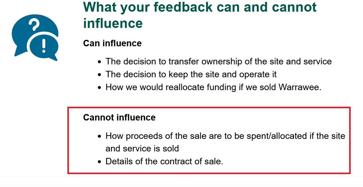
Several statements in the above media release emphasise that Warawee will not close and that the service will continue either as a council operation or by another organisation. We then have to query why in the accompanying Have Your Say survey pages, we find the following –
Does this mean that there is a real possibility that the site could be sold? Doesn’t this contradict what the above media release has stated? Will we be informed prior to any sell off decision or will we see a repeat of what occurred a few years back?
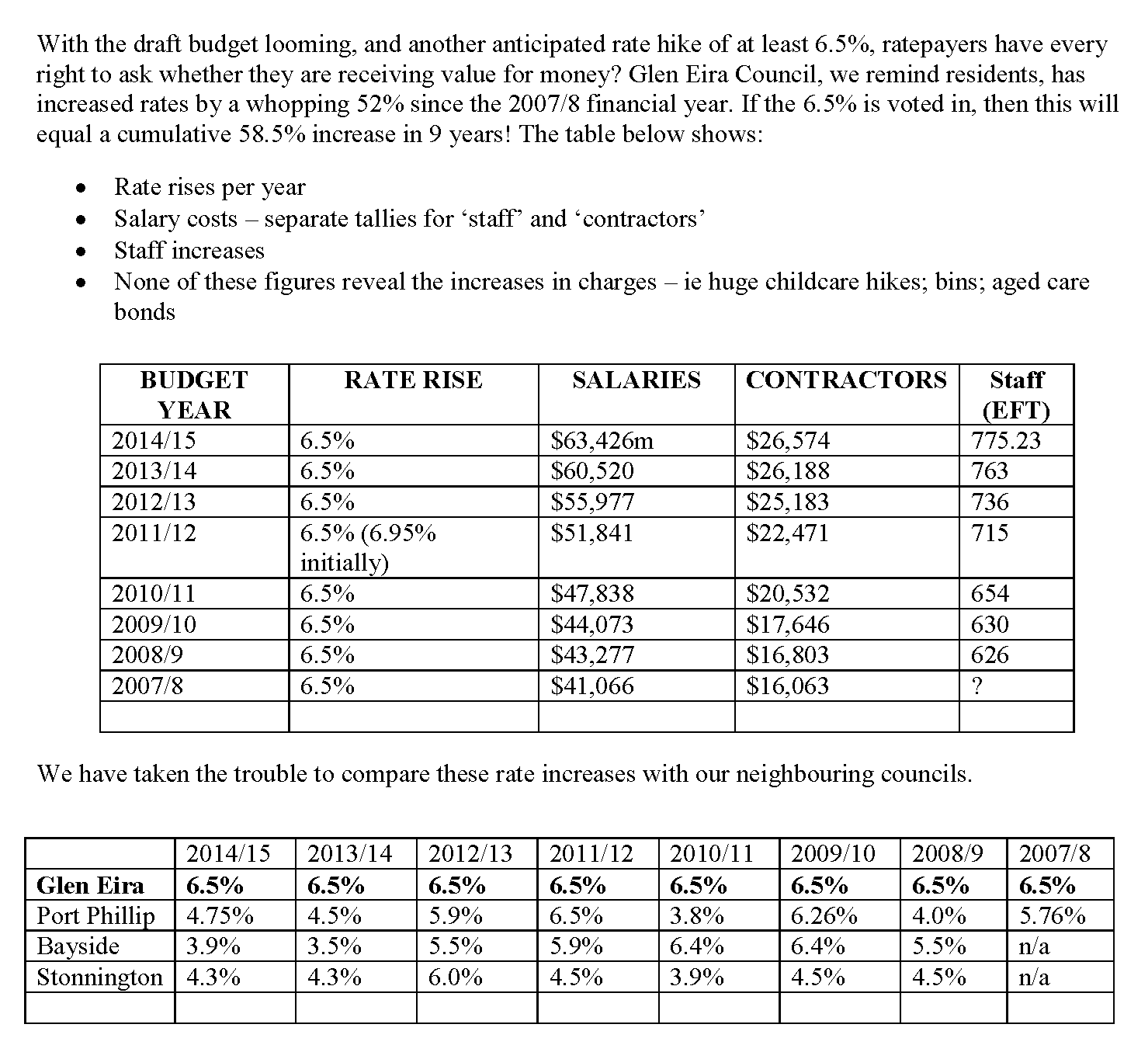
Going back over past budgets, we find a few interesting facts in terms of stated deficits.
We have no doubt that regulations, staffing and overall standards have changed. But again we have to question why only two years ago the deficit for running one facility was $2.7M and has more than doubled in the space of 2 years. Surely it can’t all be due to government changes? Or how much has this been caused by years of lack of attention to the facility and then having to upgrade? Surely it would be informative if council produced some detailed information as to how this $5.5M deficit is calculated and verified?
The bottom line in our opinion is that if council is really there to serve the community, then it is the community who must decide whether they wish to subsidise this service.
We received the following email from a resident in response to our post on council’s desire to raise the rate to 5% for the following financial year. Here’s what was written:
Hello – there is another aspect – being the difference between Local Government Receipts that are not taxed and the community “worker/family” cash on hand to pay rates – which they have to earn and pay for their rates “after tax”.
The increase from 2.75% to 5.0% is an effective 2.25% increase or 81.82%
increase on the effective rate (as always for any small percentage base) Local Government benefits as they do not pay tax on their receipts. But communities under economic and wage strain – the families the councils say are also vulnerable and others which are under cost of living pressure with high mortgages and families to feed only have after tax dollars to pay those rates
If Glen Eira is saying the average rate is ~$1,600 then a resident has to earn $2,080 to have the $1,600 cash (based on 28% tax +2% Medicare levy). The Council collected $113m in rates yet the before tax impact on residents (with assumptions) would be close to$146,900,000. If now Glen Eira is saying to increase rates to 5% (2.25% addition to the base 2.75% – an 81% increase) then for the resident to pay the $1,600 X 5% next year = $1,680. But that is not where it stops. For the resident to earn $1,680 in the bank before tax they have to have gross wages of $2,184 – that is a part cause of inflation and the cost of living stress. Over 71,000 (and rising) number of rateable properties x the difference between $2,184 and $2,080 =$104 x 71,000 = $7.38 M – taken from Glen Eira before tax wages.
The potential rate increase is not good local government policy when balanced against the need and strategies to support communities – and their Health and Wellbeing plans, especially when the 2025 budget demonstrated an excess of $5M, which could be/should have been held aside, in trust, to assist with next years cash so called “stress”.
Fluff and bubble really – and blindness to the real world… really. Forensic real costs convert wages paid by employers to before tax – on the basis of statistics and “$1 for $1 equal basis” with Local Government who do not pay tax.
(We do not have a mortgage and we are fortunate – but the argument above is for the wider good)
Item 10.1 of the latest council agenda, contains this paragraph and its recommendation:
This report recommends moving forward on this a key element of the Strategy. It proposes a one-year 2.25 per cent variation above the announced rate cap of 2.75% for 2026–27, a total increase of 5 per cent in 2026–27 generating approximately $3 million additional rate revenue per year
The officer’s report goes on to claim that overall the community supports council’s ambition to increase rates and this is ‘evidenced’ by an enormous round of community consultation held over the past few years.
This approach reflects strong community input over the past two years. Through comprehensive engagement programs such as Our Priorities, Our Future (2023) and Our Place, Our Plan (2025), more than 3,200 participants took part in conversations about priorities, trade-offs and funding options. In the 2023 deliberative Community Priorities Panel, 73 per cent of members supported applying for a rate cap variation as part of a broader package of measures to strengthen Council’s financial sustainability.
Sounds great, doesn’t it? – 73% supporting a rate increase!!!!! A clear majority. However, when you go back to the actual Community Priorities Panel report, we can be forgiven for thinking that this is truly representative of the community. Please bear in mind that this committee consisted of up to 39 members only and therefore hardly constituting what could be considered as genuine community representation. Hardly surprising however that the report chooses to highlight this percentage and provides no other stats from the various surveys!!!!
Even when we investigate the results from the community survey on Our Priorities, Our Future, we find the following:
• The community may be open to increasing fees and/or charges to maintain current service levels, with 52 per cent of the community responding in the ‘maybe’ range, but ‘no’ is the most common single response at 37 per cent.
Please note the phrasing of the question. Instead of calling a spade a spade, (ie rate increase) the terminology becomes ‘fees and/or charges’. This is entirely different to a rate increase and we have no idea whether participants simply saw this as raising child care fees, entry costs to swimming pools, etc instead of reading this as an increase to rates.
When the question was finally asked as to how council’s finances could be increased and the methodology council should employ to achieve this, only 10% (166 responses) were in favour of rate increases.
Even more disturbing is council’s continued refrain, that Glen Eira residents have ‘some of the lowest rates in Victoria’. When rates are calculated, please remember that this is done according to property/site value. Clearly many Bayside suburbs would have a greater site value than those in Glen Eira, and the same could be said for Stonnington. Therefore their overall rates would be higher in these municipalities. But what also needs to be taken into account is not just the final rate, but the INTEREST RATE per annum which is applied to all properties. For well over a decade preceding the state government’s rate capping introduction (2016/17) Glen Eira was the highest by far in comparison to our neighbouring municipalities. Here is a comparison we made in April 2015 –
CONCLUSION
We do not doubt that prices for everything have increased dramatically. Nor do we doubt that governments have cut back on grants and attempted to pass on more costs to councils. But does any of this really justify a 5% rate increase across the board – especially in these times and when this is backed up by some very spurious claims as to overall community support. Could we for once get an officer’s report that is not misleading and fabricated to evince councillor support?
The bottom line of course is how well council has run our finances. Did we really need an $80M mini GESAC pool? Did we really need to embark on gigantic loans that will take another decade to pay off? Questions abound. At the core is the issue of whether or not this council is truly listening to residents.
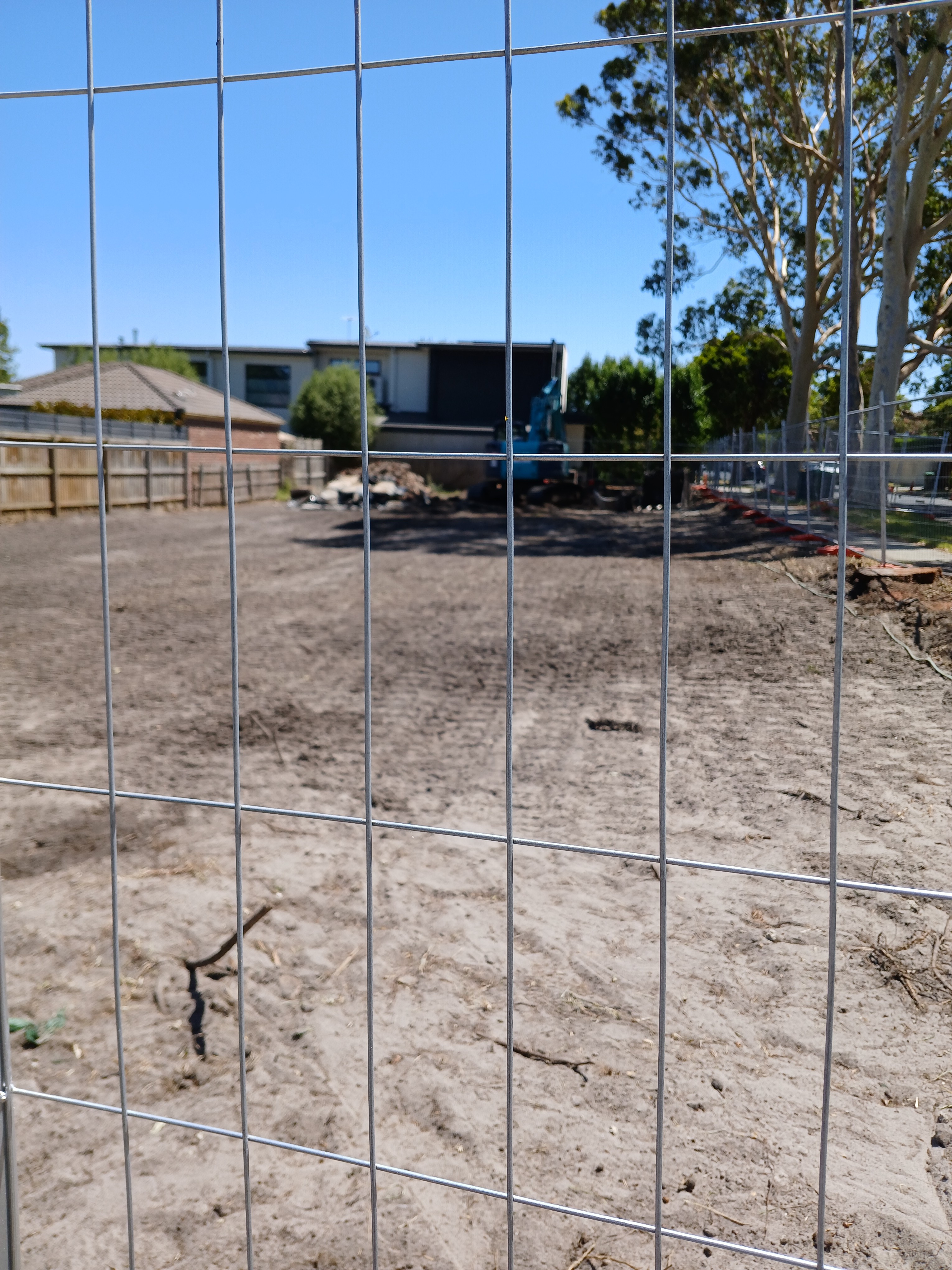
This is the tale of the complete failure of both council and the state government in terms of protecting our devastatingly low tree canopy and ensuring that moonscaping is drastically halted. For all the talk about stopping moonscaping and preserving canopy trees, the following example illustrates completely how far Glen Eira is failing in its objective.
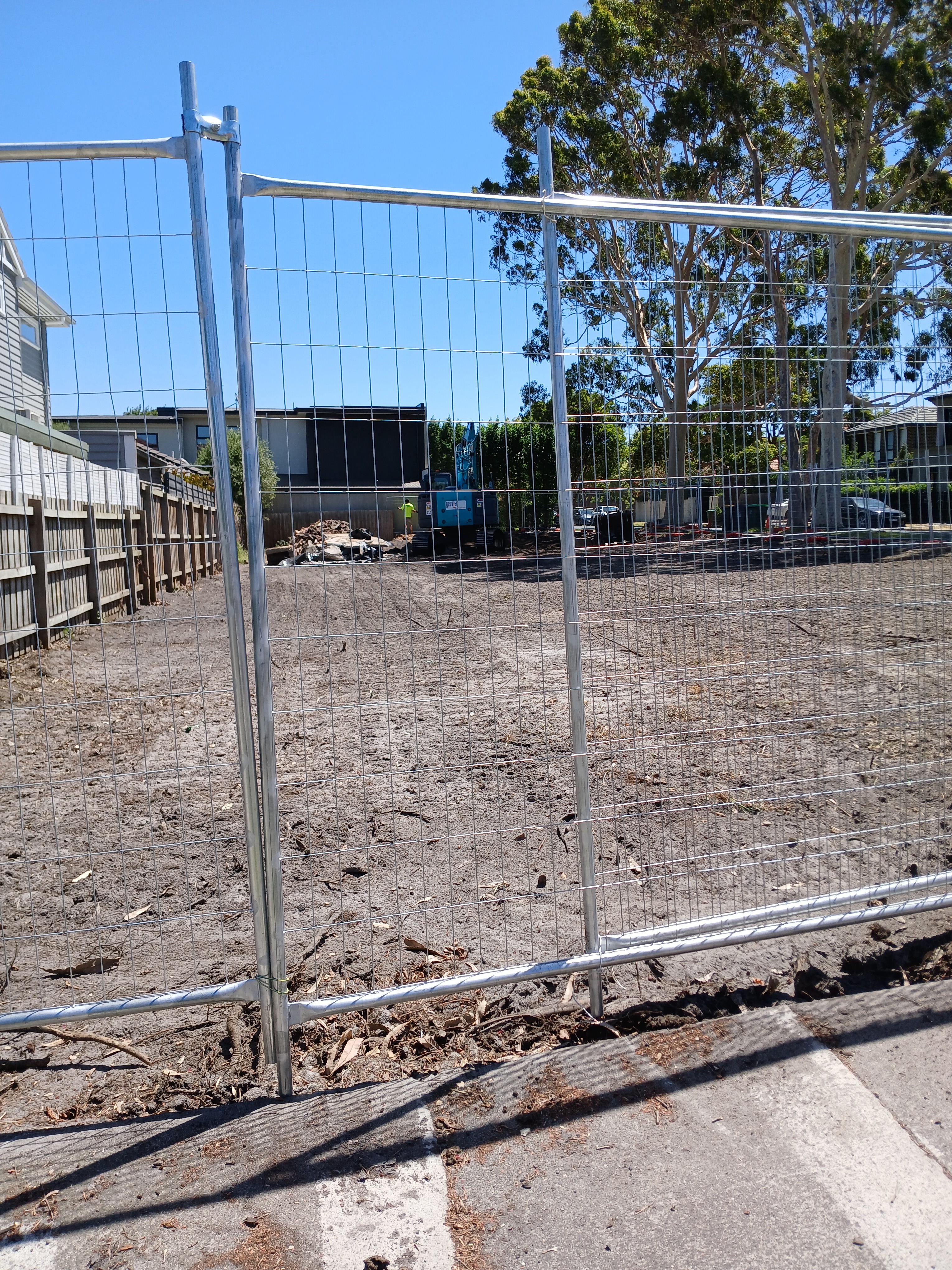
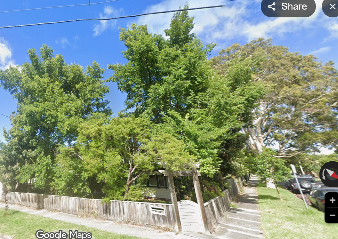
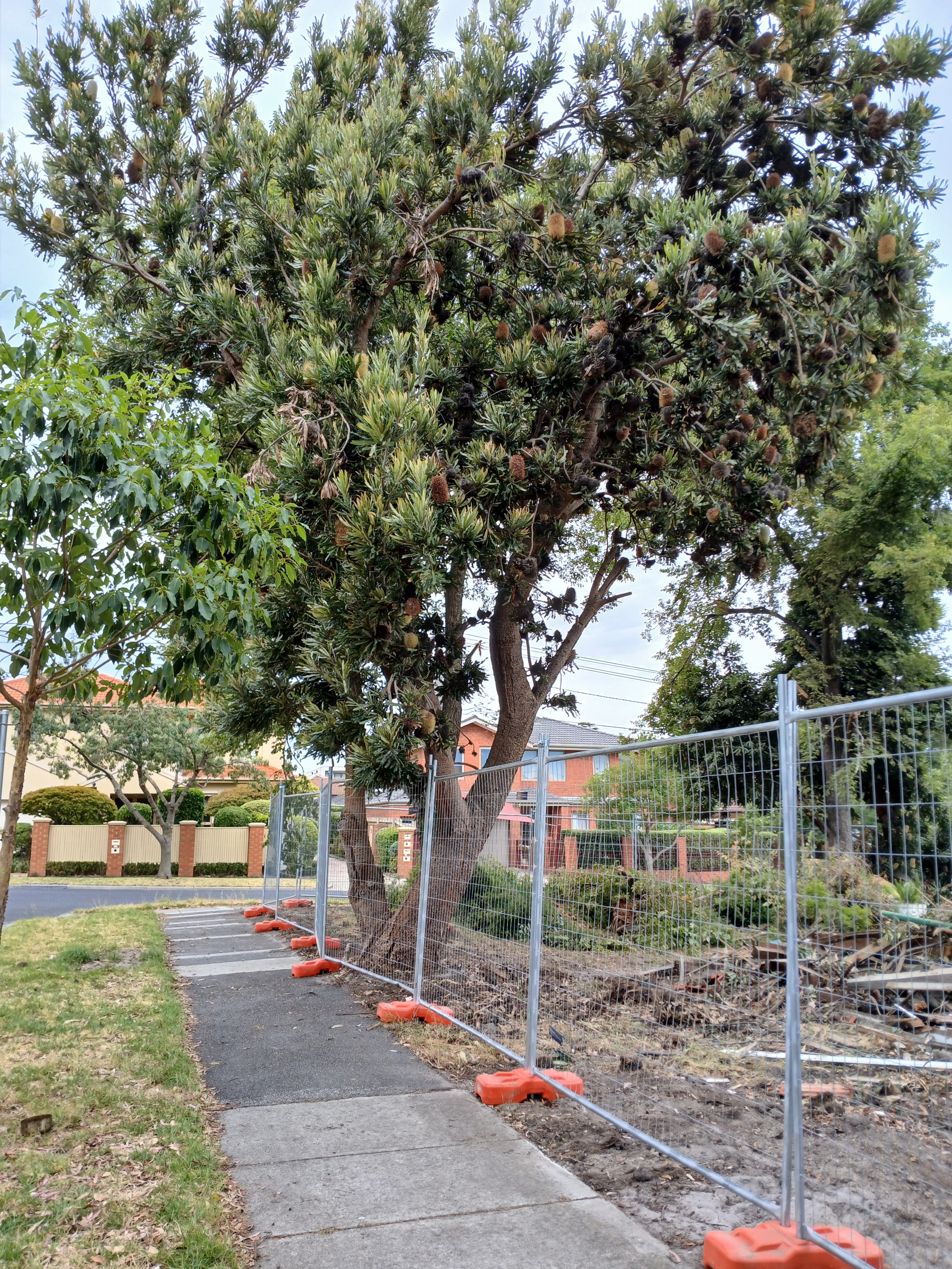
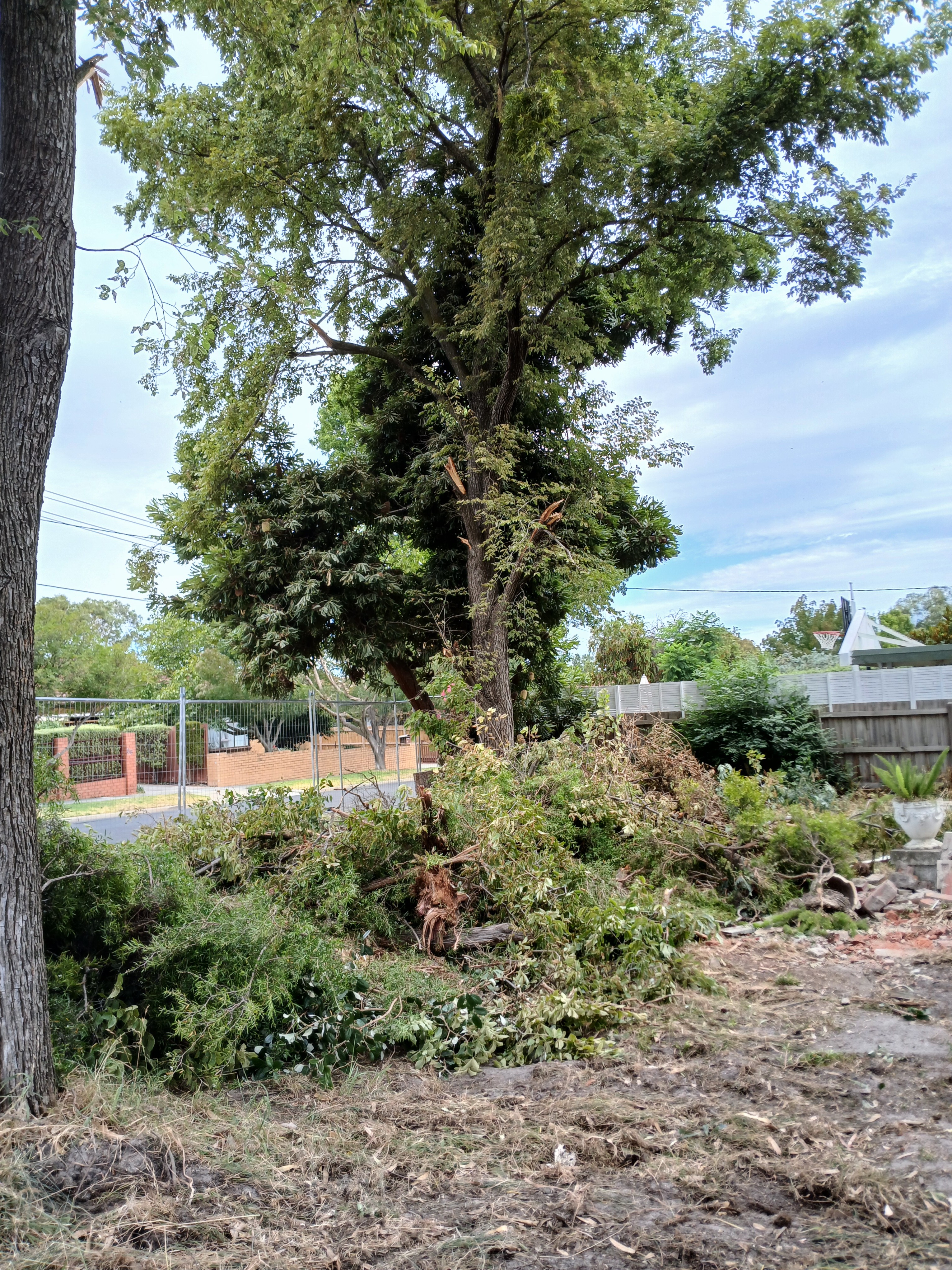
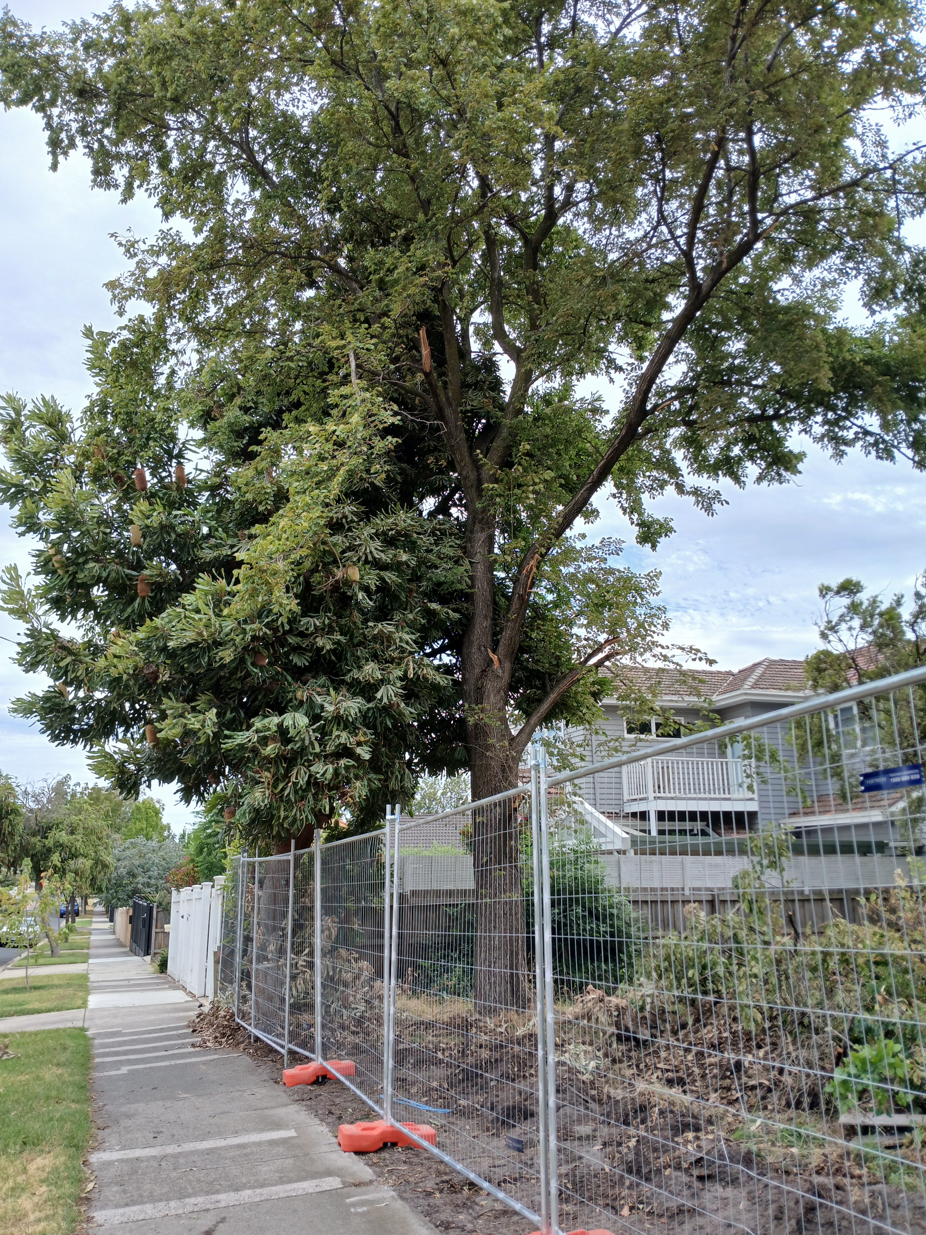
Below we feature a street map view of a property that was granted a permit in 2021 for the construction of 2 double storeys. Three years later there was another application for a permit time extension. That was granted by council in April 2024. Full demolition started this week and will be completed in the next day or two.
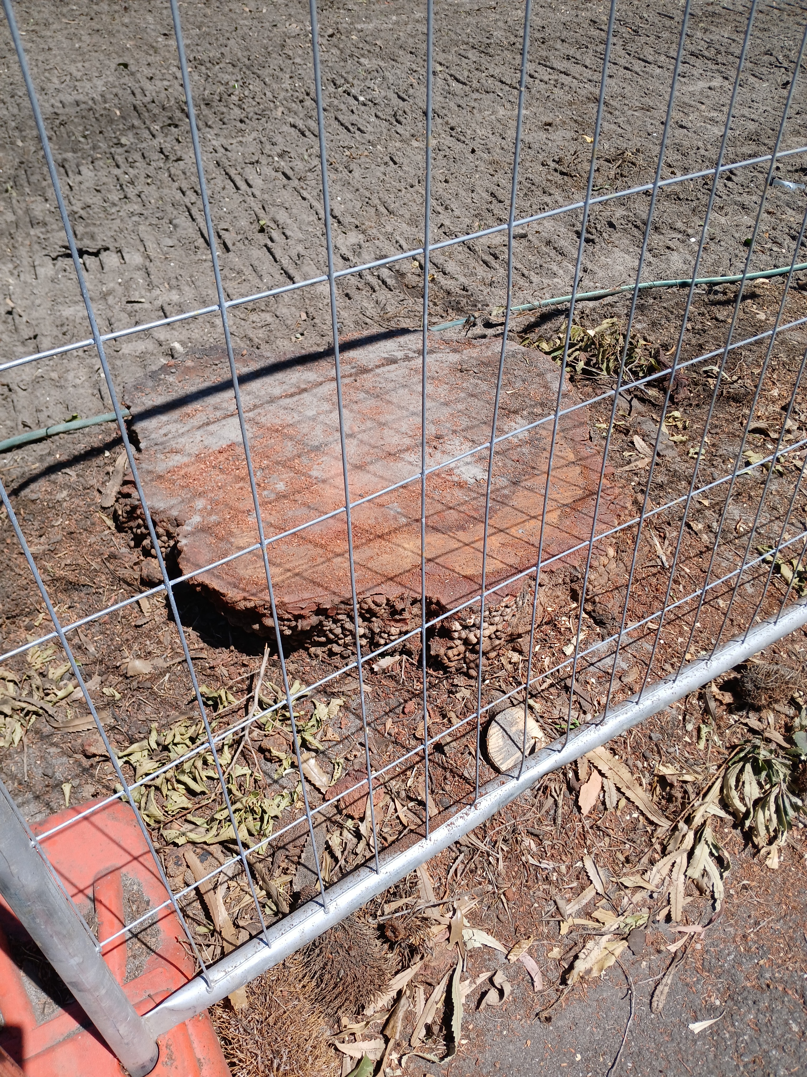
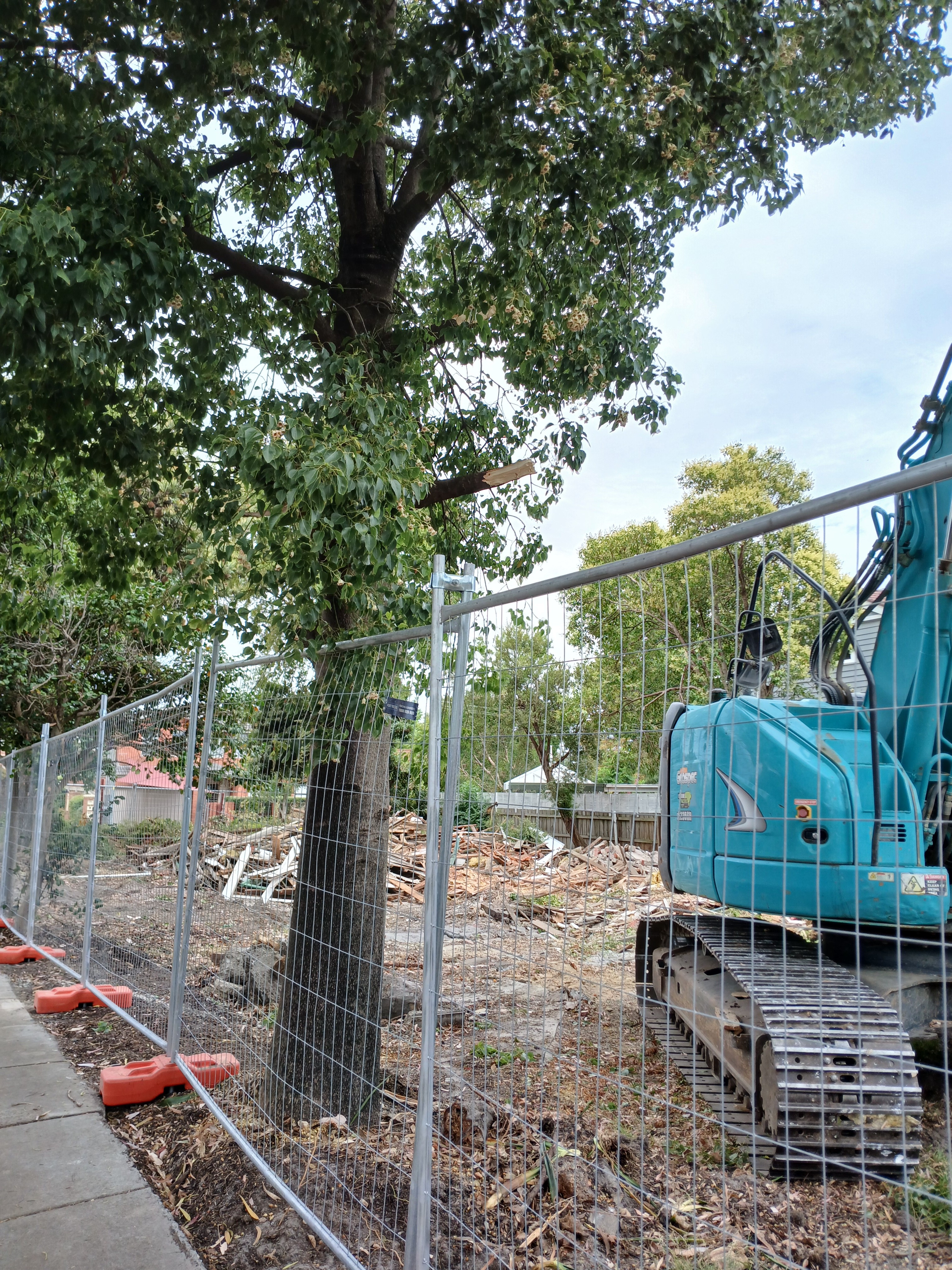
What is not clear from the above image is the fact that the property contained at least 10 beautiful and fully grown canopy trees. All of these trees would have been at least 50-60 years old (including a superb box species and a magnificent saw banksia). All of these canopy trees had been carefully planted along the perimeter of the site apart from one that was approximately 3 metres inside the front fence.
The following photos show what the site looks like now and the carnage that has been wrought on these trees. They will all be gone in the next day or so according to the tradies working on demolition.
The questions therefore abound:
Surely any decent architect could have designed dwellings where at least some of these perimeter canopy trees could have been preserved?
Why was a permit granted that presumably allowed the removal of all of these trees? Was there really nothing that council could have done?
How hard has council really tried to preserve its tree canopy, especially on private land? Yes, Council’s Tree Protection Canopy Law only came in last year so would not have been applicable to this planning application. This however does not absolve council of all blame. For years now, there have been options available to councils such as vegetation overlays (especially for classified trees) that several councils (ie Moonee Valley, Whitehorse) have introduced. But not Glen Eira. Their argument has been to wait for the state government to carry out the requisite work. Well in September 2025, the government introduced a new amendment that falls far short of truly protecting the environment and achieving the goal of 30% tree canopy coverage in the decades ahead across the state.
Boroondara at its December 2025 meeting pointed out the drawbacks of the state government amendment – cited below
During the course of the consultation, the Victorian Government introduced new tree planning controls through a Particular Provision at Clause 52.37 of the Planning Scheme. These new controls apply universally to all residential zoned land across Boroondara and metropolitan Melbourne and introduce new standard planning permit triggers for the removal, destruction or lopping of a canopy tree in the front and rear setback of a site.
While the introduction of consistent, state-wide tree controls is welcome, there are some concerns with the detailed permit triggers. Overall, the provision provides protection for canopy trees only in the front and rear setback of lots and makes no allowance for consideration of significant trees including works that may impact a significant tree.
Generally, it is considered that the new Particular Provision provides less protectionfor canopy trees and significant trees than the existing local law and the proposed new overlays. It is therefore recommended that Council continue to seek authorisation for the proposed new overlays as discussed in this report.
Boroondara is now pushing ahead to ensure that tree protection resides in the planning scheme and not simply in a council’s Local Law. This is something that Glen Eira should have sought years ago.
The example we’ve provided tells us how vulnerable our valuable trees are today – despite all the rhetoric on tree protection. The onus is clearly on councils to both introduce and enforce laws that are fail safe and do the job they are supposed to.
The issue is not about development versus tree protection. It’s far more fundamental than that. Development can occur and should occur if all necessary actions are taken to preserve the health of our dwindling canopy coverage on private property. Is the ability to build a few extra feet of dwelling space worth the loss of our most valuable vegetation and aspects of our neighbourhood character – especially in an era of dramatic climate change?