The last time the community was permitted to provide input into a planning scheme review was in 2016. Thus ten years have passed, three previous reviews have come and gone and council still sees no need to allow residents to have their say on this important document which is up for decision at Tuesday’s council meeting.

The main argument council provides for the refusal to allow ‘consultation’ is (and we quote) –

Given the short time frame set by DTP, there was insufficient time to engage with the community.

However, once the Planning Scheme Review Report is endorsed by Council it will be published on Council’s website. (!!!!!!!!!!)

Council tells us that they received the order from the Minister in January 2026 that the review was to be completed by the end of October. That is a full 9 months! Ironically, when a public question was asked on the 2/5/2023 in regards to community consultation for the upcoming 2023 planning scheme review, the final paragraph of council’s answer was:

Council officers regularly brief Department of Transport and Planning representatives on the progress of our strategic planning work program and have committed to provide a review within 6 months to the Department. Once the internal review is nearing completion, Council will be in a better position to confirm the nature of any further consultation.

Needless to say, there was no community consultation then! However, council still thought that it could get things done in 6 months! Now they have 9, and we assume ongoing ‘discussions’ with the department and Minister have continued, but this isn’t enough to engage the community in 2026!

We certainly acknowledge that the last 18 months or so has seen a landslide of government changes to the planning scheme, all of which have, and will have, a dramatic impact on councils. But it’s not as if councils weren’t forewarned as to what was happening. Submissions were asked for and sent off, as well as continued ‘advocacy’.  

Thankfully, not all councils operate as Glen Eira does. To various extents, they value their communities and do provide them with the opportunity to have a say!

The following group of councils are ALL providing community consultations for their 2026 Planning Scheme Reviews. Most are regional councils so may not be impacted as severely with the Activity Centre changes as our metropolitan neighbours. But they do have their own issues to deal with that have been impacted by legislative changes – ie huge population growth in many, environment, etc.

We should also point out that not all councils have released their reviews and the processes involved. Some have asked for extensions.

The focus of this post has been on the lack of engagement with the community. Our next post will evaluate the actual review and compare it with other councils.

Cardinia – https://www.cardinia.vic.gov.au/news/draft-planning-scheme-review-part-b-public-exhibition

Mornington Peninsula – https://shape.mornpen.vic.gov.au/mps-planning-scheme-review-2026

Moonee Valley – https://yoursay.mvcc.vic.gov.au/planning-scheme-review

Mansfield – https://www.mansfield.vic.gov.au/community/news/local-knowledge-sought-2026-planning-scheme-review

Macedon Ranges – https://yoursay.mrsc.vic.gov.au/Planning-Scheme-Review

Yarra Ranges – https://shaping.yarraranges.vic.gov.au/yarra-ranges-planning-scheme-review-2026

Mansfield – https://www.mansfield.vic.gov.au/community/news/local-knowledge-sought-2026-planning-scheme-review

Kingston – https://www.yourkingstonyoursay.com.au/planning-scheme-review

Greater Dandenong – https://yoursay.greaterdandenong.vic.gov.au/strategic-planning-work-program

Whittlesea – https://www.whittlesea.vic.gov.au/Services/Building-planning-and-development/Strategic-planning/Planning-scheme-and-amendments/Planning-scheme-review

South Gippsland – https://www.southgippsland.vic.gov.au/PlanningSchemeReview2026

Baw Baw – https://www.bawbawconnect.com.au/planning-scheme-amendment-c157bawb South Gippsland – https://www.facebook.com/southgippslandshirecouncil/posts/-were-reviewing-the-south-gippsland-planning-scheme-and-we-want-you-to-share-you/1475486824605666/

The agenda for the upcoming council meeting includes the 2025/26 Annual Report. We have previously commented on the lack of detail (and therefore transparency) especially in relation to the Urban Forest Strategy and the goal of increasing our overall tree canopy to 22% by 2040.

The following is conclusive proof that we are indeed going backwards when it comes to our tree canopy. All of these figures are taken from the respective Annual Reports. What they clearly show is:

  1. A failure in the past 5 years to nominate the number of ‘replacement’ trees. Hence, we have no idea as to whether Glen Eira is increasing its number of trees, or falling further behind. Also, please remember that these numbers do not include what has been happening on private property.
  2. The numbers of ‘new’ trees planted was relatively steady (approx. 1000 per annum) up until 2019/20. Since then, it has been on a downward spiral.

Here is the data:

2011/12 – 1,684 street trees (526 replacement and 1,158 additional)

2012/13 – Plant 1,600 street trees (estimated to be 1,000 replacement trees and 600 additional trees).

2013/14 – We planted 1,681 street trees (1,080 replacement and 601 additional) and lifted the number of future plantings to 2,000 per year.

2014/15 – We planted 2,360 street trees (1,360 replacement and 1,000 additional)

2015/16 – We planted 1,050 replacement and 950 additional street trees.

2016/17 – . 2090 trees planted

2017/18 – . We planted 2,038 street trees (913 replacement and 1,125 additional)

2018/19 –  We planted 2,077 street trees (940 replacement and 1,137 additional).

2019/20 –  We planted 950 street trees (684 replacement and 266 additional) which was 1,050 under target due to COVID-19 restrictions.

2020/21 – We planted 1,854 trees (854 replacement and 1,000 additional).

2021/22 – 1008 trees planted

2022/23 – 872 trees planted

2023/24 – 2,241 trees planted

2024/25 – 1,189 trees planted in streets, parks and reserves

2025/26 –  1003 trees planted

In 2002 our overall tree canopy was 25%. Two decades later we were told that it had declined to 12.5% – literally halved. The cause was largely put down to urban development on private land. With the introduction of the Urban Forest Strategy (UFS) in 2021, the target increase was eventually set at 22% by 2040. It bears remembering that council had to be dragged screaming to this figure since the draft UFS had officers recommending a target of 14% by 2040.

Since the introduction of the UFS, practically nothing has been published as to how well Glen Eira is doing in achieving this target. We don’t know:

  • How many canopy trees have been removed on private land
  • Given that we don’t know how many planted new trees are ‘replacements’ for those already lost, the overall planting figures in parks and streets provided by council are meaningless. Without knowing how many trees are removed each year in these areas, the planting figures fail to reveal the true nature of our increasing or declining tree canopy.
  • Nor do we know what council’s success rate is in the planting of new trees, nor how much wastage and poor maintenance, costs ratepayers. Anecdotal evidence tells us that many new plantings simply do not survive the long haul to maturity.
  • Do we actually have a pruning schedule? A watering schedule? An inspection schedule? If so, why aren’t these in the public domain?

To sum it all up, we have no idea if we are in fact anywhere near the target of 22% by 2040. For all we know, and suspect, we believe that we are continuing to go backwards, and fast, given recent history. If we are indeed going backwards, then it raises the important issue as to ultimate targets to address the decline. Namely, is 22% enough to halt further decline? Is the current funding allocated, sufficient?

Finally, we present the following stats as a comparison to what other councils set their targets at. Some of these UFS were introduced between 2021-24 and hence will soon be updated we assume. Some councils in the western suburbs have lower tree canopy coverage, but they have also been provided with massive funds from the State Government to increase their overall coverage. The telling point is that for the vast majority of these councils, a figure of 22% by 2040 was obviously seen as inadequate. Not so Glen Eira!!!!!

GLEN EIRA – 22% by 2040

BASS COAST – 40% by 2040

BAYSIDE – 30% by 2040

BANYULE – 30% by 2050

BRIMBANK – 30% by 2046

BOROONDARA – 30% by 2030

HOBSON’S BAY – 30% by 2040

MELBOURNE – 40% by 2040

MERRIBEK – 29% by 2050

MONASH – 30% by 2040

MOONEE VALLEY – 30% by 2040

NILLUMBIK – 40% by 2040

PORT PHILLIP – 30% by 2040 (to be included in 2026)

WHITEHORSE – 30% by 2050

For years now, we have queried the usefulness, validity, and objectives of the various consultation processes adopted by our council. Of particular concern, surveys have always been at the top of our list. Not only are they designed to create the illusion of genuine consultation, but they are also designed to produce so called results that either support already made decisions, or are so vague and meaningless that the answers can be manipulated any way wished.

The latest example of this sham comes in the form of the Community Voice survey on Growing Glen Eira’s urban forest. Here is one of the questions presented in this survey.

Increasing tree canopy on private property

Trees and vegetation on private land are an important part of Glen Eira’s urban forest. As Glen Eira grows, maintaining and increasing tree canopy requires action on both public and private land.

We’d like to understand what residents are already doing, what more they would like to do, and any opportunities or barriers they experience.

Which of the following apply to you?  Select all that apply

 I have planted one or more trees where I live

I plant or maintain shrubs, garden beds or other vegetation where I live

I have created habitat for wildlife where I live

I have reduced hard surfaces and increased garden areas where I live

I grow plants in a courtyard, balcony or other small space

I would like to do more to increase trees and greenery where I live

None of the above

Other (please specify)

COMMENTS

The stated title of this survey is ‘growing the urban forest’. Tree canopy coverage is a crucial element of any urban forest and has been admitted so by council – especially when the reason for the drastic decline in our tree canopy is the continued moonscaping of private land. This was the reasoning behind the introduction of council’s recent Canopy Tree Protection Local Law.

Thus, instead of a question that looks at the wider implications of  how we can ‘increase our tree canopy’ (ie the heading for this question) the focus is exclusively on ‘where I live’. Asking residents whether or not they have planted a tree on their property, or reduced hard surfaces etc. tells us nothing about –

  1. How many new trees residents may have planted compared to how many have been lost
  2. Nor does it tell us anything about what has been happening throughout the municipality and how many trees have been lost to development
  3. Even the last question about the desire to ‘increase trees and greenery where I live’ is meaningless without providing respondents with options that are available. Furthermore it again focuses on the individual’s property rather than the wider community. There is not a single word that explores what council can do to stem continued canopy loss.

The point of all the above is that residents alone are powerless to stop development and subsequent moonscaping. That is the role of councils and appropriate legislation, enforcement and vigilant monitoring.

Council is now in the throes of ‘refreshing’ the Urban Forest Strategy. They have already admitted that they have no idea how many canopy trees have been lost on private land. Nor have they told us how many trees have been lost on public land. For years now, all we have been told is that council plants anything between 1000 and 2000 trees per annum. No mention of how many are replacement. We have no idea whether our tree canopy is in fact anywhere near the target of 22% by 2040, or whether it has in fact declined. Even the government’s recently announced target of 30% coverage by 2050 seems a million miles away for Glen Eira.

Other councils (ie Whitehorse) have put their money where their mouth is by using the latest technology (IE LIDAR) to accurately evaluate their tree canopy. They have also introduced amendments that go into the planning scheme and hence have more power to stop canopy tree loss on development sites. In Glen Eira, the argument has always been it takes too long, costs too much, and we’re happy with our Local Law alone.

If the current ‘refresh’ of the Urban Forest Strategy is to be a genuine attempt to introduce measures and data that will help increase our tree canopy  and maintain sustainability in the municipality, then the questions set in the current survey simply do not do the job. They are nothing more that ‘feel good’ nonsense that tells us nothing and certainly does not point to any potential future plan of action.

Glen Eira Council has failed dismally in informing its residents as to the impact of the State Government’s ad hoc planning changes – which have all been done in indecent haste and without genuine consultation. There is no excuse why, we estimate, most of our community has no idea as to what these changes mean for their neighbourhoods and their amenity or legal rights. All that Glen Eira has managed to do is bury some waffling statements on the website that lack detail and a comprehensive analyses of consequences.

To illustrate how far other councils have gone to keep their residents informed and engaged, we’ve uploaded just one paragraph from a series of officer reports from the August 17th meeting at Boroondara. Please note all the avenues pursued by this council to ensure that their community is aware of what is happening and how it affects them.

Source: https://www.boroondara.vic.gov.au/media/121981/download?inline

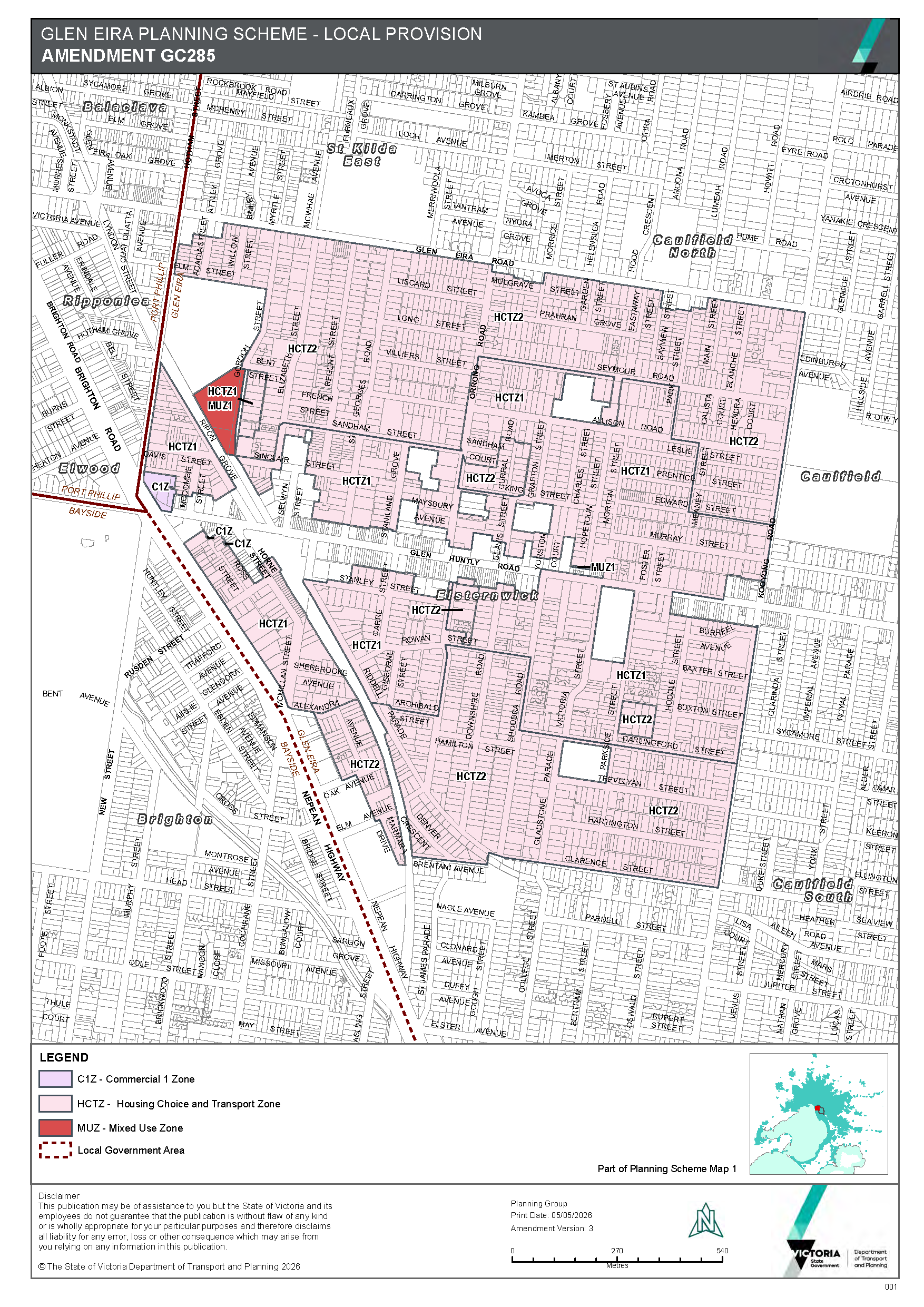
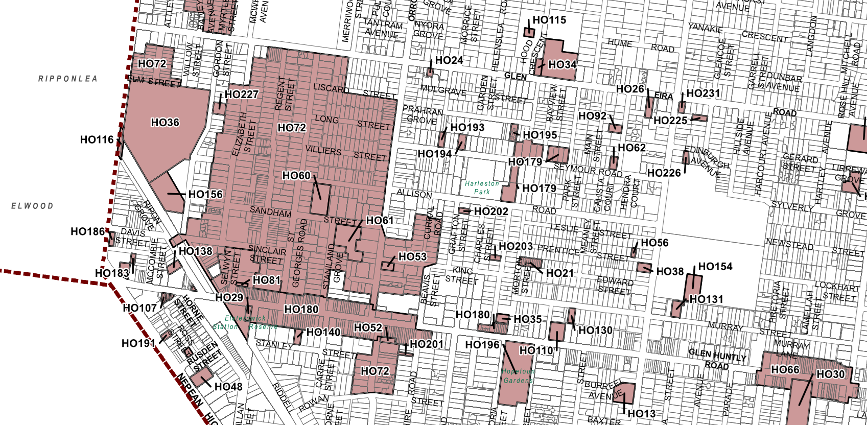
Below are the HTCZ catchment rezonings for Elsternwick. We follow this up with a map showing the current areas under Heritage overlays. Please note how many remain in the ‘inner catchment zone’ – ie 4 to 6 storeys in height.

The government has today gazetted Amendment C285 which includes the final planning rules for our activity centres and surrounds. This post concentrates on these surrounds and what has changed. Areas now zoned HCTZ2 are rezoned to allow 3 storey apartment blocks and HCTZ1 four storeys and up to 6 on large sites over 1000 square metres. Heritage in these areas is largely ignored and they are in both HCTZ zones. The following gazetted map clearly outlines what has up to now largely been NRZ is finally gone!

CLICK TO ENLARGE

PS: Here’s a media release from Liveable Victoria. Nothing yet from Glen Eira!!!!

At last several councils have decided to fight the State Government’s ad hoc planning decisions with concerted legal action. The latest comes from Boroondara and their appeal to the supreme court. In contrast Glen Eira sits back and continues to be silent and compliant, despite the fact that our municipality is being torn to shreds with amendment after amendment that lacks evidence, transparency and full accountability.

Here is the Boroondara media release. (See: https://www.boroondara.vic.gov.au/your-council/news-and-media/media-centre/media-releases-and-statements/boroondara-seeks-judicial-review-ministerial-planning-permit)

Boroondara seeks judicial review on Ministerial planning permit

Tue 14 July 2026

The City of Boroondara has served Supreme Court proceedings on the Victorian Minister for Planning, Sonya Kilkenny MP, in relation to a planning permit she issued for the redevelopment of the Leo’s supermarket site in Kew. 

The Minister’s decision is being challenged because she did not appropriately consider the applicable planning controls and whether the developer had permission to use Council land to build the project.

The planning permit allows for the development of four towers on the site with a maximum height of 18 storeys, exceeding the government’s own height controls for the site (16 storeys), which were only recently published on 18 March 2026. The previous height limit for this site in the Kew Structure and Place Plan was 9 storeys and was approved by the Minister for Planning on 4 May 2017.  

The development also proposes substantial alterations to council-owned and operated land, which Council has not consented to. If changes are to be approved to this land, Council is firm that the variations need to deliver a positive result for all community members, not just the developer and residents in the new development.  

Cr Wes Gault, the Mayor of Boroondara, stressed the legal action was a last resort to achieve important changes to the project. 

“We have not made this decision lightly, but we are requesting this judicial review in the best interest of our community and residents,” he said. 

“We are not opposed to this development – in fact we agree that this is a great site for a new mixed-use development – but we want to ensure the best result for our community with a building that better fits in the space, has affordable housing, and includes a public environment that delivers for all of us.”

“We submitted extensive feedback on how this development could be improved when the Minister was considering this application, and we are disappointed that few changes were made based on this considered and constructive feedback.”

We have also asked for a meeting with the Minister for Planning in the hope these matters can be resolved without the need to continue our legal proceedings.

Specific changes the City of Boroondara would like to see include: 

  • Modifications to the building’s design to reduce overshadowing concerns and comply with the government’s own Activity Centre controls;
  • guarantees that affordable housing will be built on site;
  • better landscaping, pedestrian flows, and building materials on council owned land. This land currently delivers a public benefit, and developer modifications to this space would need to be of a high quality and fit Council expectations; 
  • ensuring that any reliance on Council land for vehicular and pedestrian access is well designed, safe and fair; and
  • ensuring access to the Council-owned land is well considered and equitable to all community members.

Boroondara is committed to ensuring that future growth is supported by great services and required infrastructure and has a long track record of supporting high-quality mixed-use developments, with thousands of new residents moving to Boroondara in recent years. 

This consistent and successful growth in Boroondara over the last 30 years, where there are few large undeveloped sites, should not be directly compared to Melbourne’s rapidly growing outer suburbs where housing estates are built in greenfield areas. 

Councillor Gault concluded by highlighting that the legal action would not change Council’s ongoing work with the Victorian Government on a range of projects from library redevelopments to the development of new sporting and parkland precincts. 

“As Councillors, we will always advocate to the Victorian Government in the best interest of our residents, and I hope we can work together to resolve this matter quickly.”

The proposed development falls within the Kew Activity Centre, one of seven within the City of Boroondara. More broadly, Council has a range of concerns regarding the use of the DFP planning permit pathway. Council believes local councils should be the decision makers for development applications lodged within their local areas, and residents should have more of a say in the developments that shape the future of their streets and neighbourhoods. 

The government’s final new zonings of HCT1 and 2, are still unknown for Elsternwick, Bentleigh and a few other activity centres. However, what is already LAW, and in operation, includes the Carnegie, Murrumbeena and Hughesdale areas, as well as Moorabbin. In an earlier post, we highlighted how these changes have impacted on Moorabbin, where countless sites were given the green light to ‘upgrade’ from 2 storey height limits, to now 3 and 4. (See: https://gleneira.blog/2026/03/26/moorabbin-before-and-after/)

Below we feature what council has had to say about some of these changes. As per usual, the negatives are totally ignored, and instead, we are told about the most miniscule of ‘positives’. No mention is made of the areas affected, nor how they will specifically be impacted. Nor are we told on what basis some of the areas can become 6 storeys. Surely, if the objective is to inform the community, then much, much more detail, and commentary is required than what we get in the following!!!!!

Catchments

Residential areas surrounding each activity centre, extending up to one kilometre, will be rezoned. These inner and outer catchments will be included in either the:

  • Housing Choice and Transport Zone 1 (4–6 storeys), or
  • Housing Choice and Transport Zone 2 (3–4 storeys)

It is pleasing to see that the catchment area around Ormond and Mckinnon has been reduced in response to submissions made by both Council and the local community.

Existing heritage precincts have not been included in the inner catchment areas, with the exception of a small section of HO72 (western side of Orrong Road south of Glenhuntly Road). A small number of individually significant heritage places will be located within the inner catchment areas. 

Source: https://www.gleneira.vic.gov.au/about-council/news/latest-news/state-government-finalises-activity-centre-plans

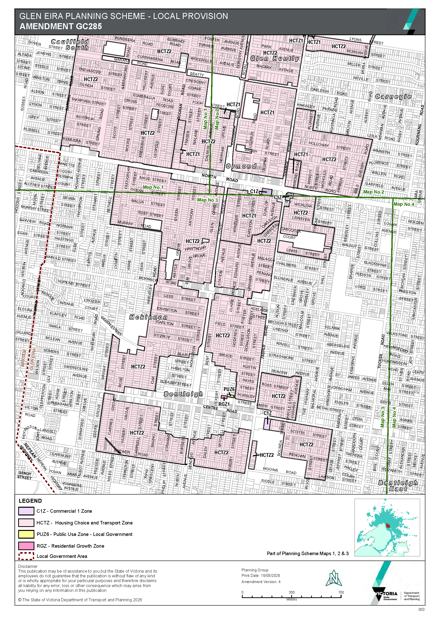
So residents can actually see the extent of change, we’ve uploaded the current zonings for Carnegie and its surrounds. Please note that the vast majority of these places have gone from a two storey height limit to anything between 4 and 6 storeys depending on the size of the allotment – eg Rosstown Road is now HCT1 (4-6 storeys) when it was NRZ (2 storeys). There are plenty of other such examples. But overall, the size of these catchments is overwhelming and totally destructive of what residents value about their local streets. And all council can state is that a lot is ‘pleasing’!!!!!!!!!

Check out the following image to discover what has occurred.

CLICK THE ABOVE TO ENLARGE

At last council meeting this public question was asked –

At the May 19 meeting, Council agreed to provide a summary of outcomes of the final State Government’s Carnegie Activity Centre plan vs Council’s Structure Plan on Council’s website so changes would be clear to the Glen Eira community. With the release of the finalized plans for the Stage 2 Activity Centres last Friday, when will that Carnegie information be available and will Council provide similar detailed explanations for all the Stage 2 Activity Centres?

Answer:

Council placed an update to the Carnegie Structure Plan 2022-Amendment C237 webpage on 19th June 2026. This included information relating to the state led activity centre plan for Carnegie approved under Amendment C278. This update included changes to over shadowing controls between the two plans.

Now that the Stage 2 plans have been released, we will provide a more detailed summary of the differences between the State led activity centre plans and Council’s Structure Plans for Bentleigh, Caulfield and Glen Huntly by this Friday, 3 July. The state led plan for Elsternwick only refers to a range of heights associated with the Elsternwick Structure Plan. The plan does not illustrate how this height range is applied to different sites within the Elsternwick core. Therefore, a summary of the state led plan and Council’s plan for Elsternwick can only be prepared once further information is released by the State Government. To note, the final controls for Stage 2 activity centre plans are yet to be issued so there may be further changes Council is not currently aware of.

COMMENTS

We have repeatedly bemoaned the fact that this council is determined to keep its residents ignorant of the significance of changes made by the State Government and how these changes will impact all ratepayers across the municipality. When public questions have to be repeated ad nauseum, and the responses and ensuing actions fail to provide the information required then we conclude once again that the objective is to fully comply with whatever is handed down by government and to treat residents with disdain.

We have finally located the so called ‘summary’ referred to above and affecting Carnegie – buried deep within council’s website and unlike Bayside Council certainly not on the council’s home page. And instead of a detailed and comprehensive summary of what the changes actually mean, the only comment made is in relation to the new overshadowing requirements. Not a word about heights, setbacks, building separation, etc. Instead of patting themselves on the back that one overshadowing requirement has now become mandatory at the equinox, rather than the solstice, council totally ignores all the other important changes.

Here’s council’s interpretation of what truly informing residents means: Please also note the use of language and how deliberately misleading it is. For example: we are told that the government amendment C278 REPLICATES what council proposed with its original Carnegie structure plan. Dictionary definitions of the word tell us that ‘replicate’ means to ‘make an exact copy’. Nothing could be further from the truth in this instance!!!!!!!

Planning Scheme Amendment C278 

The Minister for Planning has approved Amendment C278glen (Implementing the Carnegie Structure Plan) which replicates the proposed council-led Amendment C237glen.  

Amendment C278glen implements the key strategic directions of the Carnegie Structure Plan 2022 as proposed by Amendment C237 but replaces the Design and Development Overlay Schedule 9 (DDO9) with Built Form Overlay Schedule 4 (BFO4). The new BFO4 has been applied to the commercial core of the Carnegie Activity Centre. This change to replace a DDO with a BFO was made by the Department of Transport and Planning (DTP) to give effect to the State Government’s Train and Tram Zone Activity Centres Program. 

The BFO was developed by DTP as part of their Activity Centres Program to provide opportunities to streamline planning assessments and support housing growth in and around activity centres. 

The Amendment approved by the Minister implements the Carnegie Structure Plan 2022 in relation to the main commercial core area. The surrounding residential was rezoned to HCTZ under the Activity Centres Program and does not form part of this Amendment. 

Amendment C278 deletes the existing Design and Development Overlay (replaced by the BFO) and also makes consequential changes to local policy within the Glen Eira Scheme. 

Some notable changes to the council adopted version of Amendment C237glen made by Amendment C278glen include: 

  • Appling mandatory equinox overshadowing controls to the Woorayl Street Reserve rather than mandatory winter solstice controls. (noting that the independent planning panel had recommended applying a discretionary equinox control rather than the mandatory winter solstice Council was originally seeking). The final decision to apply the mandatory equinox control is considered a reasonable outcome. 
  • Amend the wording to clarify that the overshadowing requirement for the active recreation space below the Skyrail immediately west of Koornang Road is a discretionary equinox control applying between 10am–2pm. 

Nothing in the above can or should be seen as an accurate summation of what has changed!

Here are some changes not even mentioned in this so called ‘summary’.

  • Building separation in one instance has gone from the original 9 metres to 6 metres for buildings over 28 metres
  • Setbacks that were previously mandatory for the heritage sites are now discretionary
  • Building heights in several locations have gone from 31 metres to 46 metres

Until we get an honest council that is fully committed to its residents and properly overseen by councillors nothing will change!

Finally, please compare the following two maps outlining heights. The first is from council’s structure plan and the second the government change –