The prize for the most disingenuous, misleading, and completely ignorant or politically expedient comments for the year must go to Delahunty, Magee and Athanasopolous. How anyone in their right mind could even contemplate uttering the sentiment that 20+ storeys of dog boxes is acceptable, given the community’s outcry about height and inappropriate development is simply staggering. But that’s what has happened as exemplified in the following ‘debate’ on the option of seeking mandatory height controls for the Caulfield Village Smith Street Precinct.
First, some explanation is necessary. The approved Incorporated Plan for the entire Caulfield Village project includes the following:
- All stated heights are ‘preferred’ and are not MANDATORY.
- The cited heights are listed according to AHD and for the Smith Street precinct the highest is nominated as 120 metres which is then recorded as ‘typical 20 storeys’.
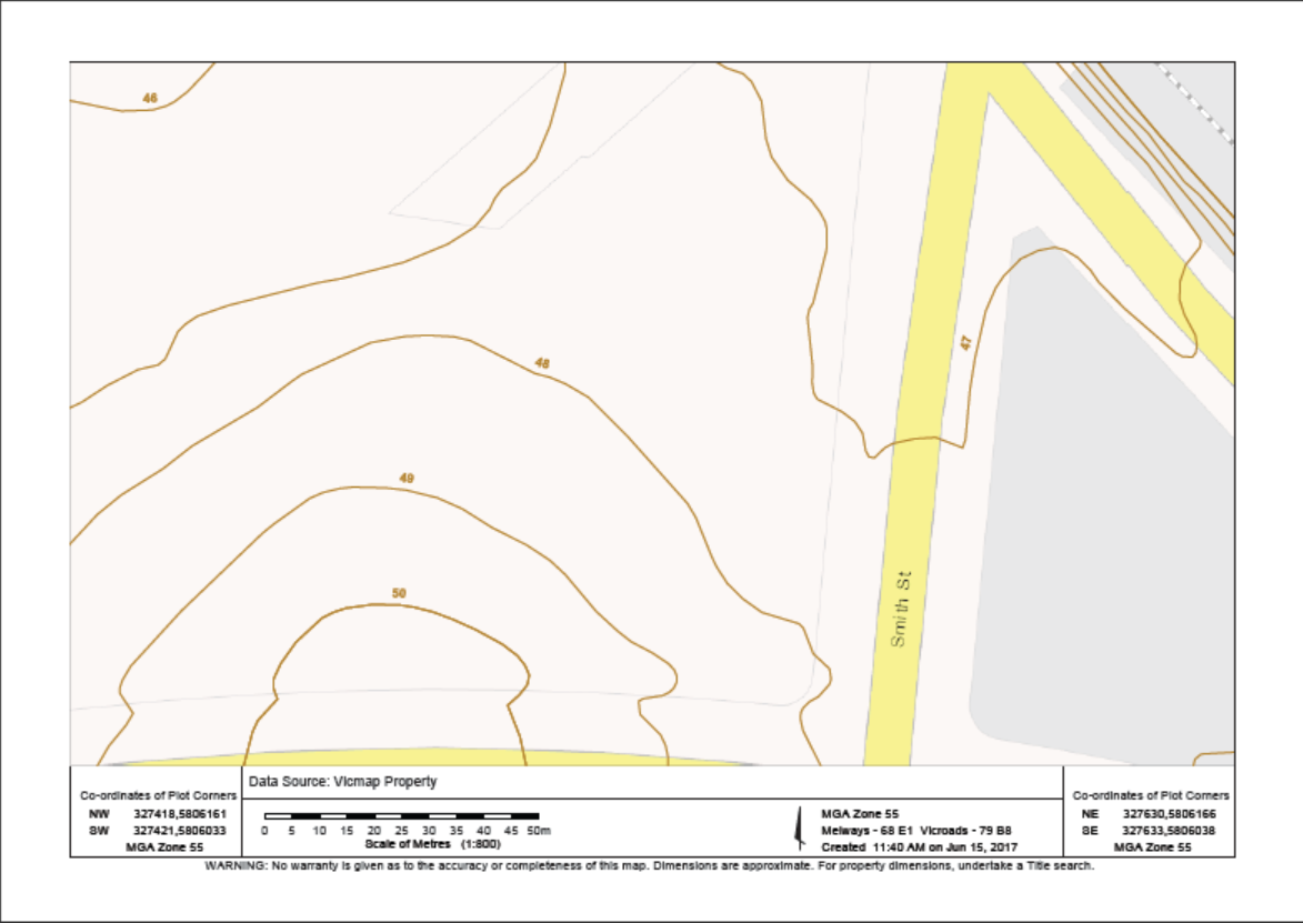
AHD, or Australian Height Datum involves calculating street level from sea levels. In other words, how much above sea level is the land under discussion. The image we present below comes from the State Government’s Land Services division. It shows the contours of the land. Readers should note that the lie of the land varies from 46 to 49 metres. Since the Incorporated Plan specified 120m AHD that means that the 46 or 49 metres needs to be subtracted from the 120 metres to get any idea of the ensuing height. If we subtract 50 metres from 120 metres, the result is 70 metres above ground level that the building can reach – unless of course the MRC decides to push the buttons on the ‘preferred’ aspect and go for higher. The Building Code of Australia sets a minimum floor to ceiling height of 2.4 metres. Thus even if we have larger floor to ceiling heights for the commercial ground floor areas, that would still leave approximately 60 metres available for residential purposes. The possible results are that the developer could quite easily construct a building of 25 and above storeys. Nothing binds the developer to a mere 20 storeys as this council would like residents to believe! – and especially not when we have a ‘preferred’ height limit rather than a mandatory one!
Please read the following carefully and decide how well these councillors are representing the community and how much they really understand as to the implications of their voting!
Delahunty moved motion to accept ‘as printed’. Magee seconded.
DELAHUNTY: thanked the resident for bringing council’s attention to the issue of ‘additional’ controls concerning heights at a recent council meeting and ‘whether or not we should look at some height controls’. Said the report gave the option that ‘we could apply to the minister to change the height controls’ or they could ‘reserve’ action until after the structure planning is done. Went on to say that ‘at the moment’ the Smith St precinct has height that varies from ’12 to 20 storeys’ and if the developer wanted to go over this height limit then ‘they would have to go through a planning application’. She therefore ‘supposes’ there is a ‘large disincentive’ for the developer to do this. Said she wasn’t ‘of a mind to impose anything additional’ on the developer that ‘isn’t in keeping with that particular precinct’. Her concern was getting ‘nice apartments’ and ‘not how high’ those apartments are. ‘I’m not particularly concerned about that’ or the ‘height of the Smith Street precinct at the moment’ because ‘I do not believe it will go over 20’. Admitted that it has been ‘much debated, much hated, but it is what it is’. It’s on an ‘incredibly major transport hub’ with no open space, but this ‘will change’. ‘So it’s right and proper that it takes a fair bit of development’. ‘So the height is of less concern to me personally’ than who will live there – ie affordable housing. This is where ‘I am suggesting we focus our energies’ and that’s why ‘I endorse that we reserve our considerations’ until the structure planning strategies are done. Said that it was ‘good’ to have to consider this and to have the reminder that there is a ‘built in disincentive for the developer’.
COMMENT
- As to the Incorporated Plan being a ‘disincentive’ this is utter hogwash. If anything it and the history of this project are INCENTIVES, since the MRC has won every battle it has chosen to pursue at VCAT – and all with council’s complicity, or cave- ins. There is no reason to suspect that any future visit to VCAT will result in a different outcome if council does not strengthen its controls. And that, this motion has explicitly refused to do. Readers need to question why?
MAGEE: ‘like you’, I ‘certainly don’t have any issues with a 20 storey building on that site’. Said it can already be ’22 storeys because what we’re talking about is height’ and by lowering the ceilings for each storey they can fit more storeys in. So on the ‘number of apartments’ there is ‘room to move’ but the overall height ‘can’t change’. ‘If you’re not going to put this sort of density around major transport’ hubs then ‘where are you going to put it?’ Went on to say that it does lack open space so ‘where can we find open space’ and implied the racecourse. Said that the precinct will also have commercial areas and that will bring ’employment opportunities’ and ‘right next to a railway station is a great incentive’. Didn’t think they should go to the government and try to get anything that’s ‘not there right now’. What’s there was ‘put in place many years ago and I believe we’ve moved on from that’. Went on to say that this is ‘really a great opportunity for people who don’t want to have a car’ to ‘live in a precinct’ that will give ‘unprecedented opportunities for public transport’ and ‘overlooking’ one of the most valued and ‘new open space’. With developments of this size there are ‘security’ issues but what council is ‘talking about today is not security, not open space, but height limits’. What’s there now is ‘may be not’ what was originally wanted but he thought it could be. ‘detrimental if we try and change that’ because ‘it could be changed the other way and we could see something that is quite significantly higher’
COMMENT
- Money is NOT IN RETAIL, but in residential. That’s why the MRC has almost halved the originally mooted amount of commercial space in the development. For Magee to therefore spruik the ‘employment’ benefits of commercial space is a nonsense. We would not be surprised to find that the next development plan intends to cut the already reduced commercial space by another few thousand square metres and instead go for more apartments. Since nothing about this entire project is ‘mandatory’ the MRC can do what it likes – and it has!
- Just because something has ‘been in place’ for years and has time and again shown to be inadequate is NOT AN ARGUMENT NOT TO TRY AND REMEDY THE SITUATION.
ATHANASOPOLOUS: asked if there was any site within the area that could provide space for ‘consumer car parking’ and whether ‘we’ve ever looked at the opportunity’ provided by the racecourse for ‘visitor car parking’?
TORRES: said it was a ‘private development on private land’ and so ‘the approval doesn’t envisage private car parking but it does envisage providing enough car parking for the various uses’ that will be ‘developed on this land’.
COMMENT
- Athanasopolous’s question to Torres displays not only ignorance of the history of this project – for which admittedly some slack may be given – but surely when a councillor is about to vote on an important issue, he should make it his business to find out about the history of the project. If Athanasopolous had bothered to do his homework he would have found that on the issue of using the centre of the racecourse as a car park, both the community and council for that matter were strongly opposed.
- Torres also needs to be ticked off on his response since it is only half true. The ‘various uses’ may be met, but there is no visitor car parking – agreed to by council!
MOTION PUT AND PASSED UNANIMOUSLY