GE Transport


Over this last weekend, the State Government convened its Community Reference Groups ‘consultations’ over the proposed Stage 2 Activity Centre Program. As anticipated, this was nothing more than another ‘tick the box’ exercise in political gaslighting designed to evince ‘support’ for already made planning decisions.

For starters, attendees were told that they could NOT comment on anything to do with the CORE areas of the activity centres. Thus, proposed and contentious height limits were off the table. All that was open for ‘discussion’ were the nominated catchment areas. And even for these catchment areas, the focus was not on their extensive ‘upgrading’ or the evidence to support this.

Whether this state government actually listens to what was said (although unasked for) remains to be seen. But we certainly are not holding our breath for any major changes that accord with community and even council views.

As for Glen Eira, we are still awaiting its submission and its recommendations. Boroondara has published their version in a comprehensive and critical analyses. One of their main points is that a ‘one size fits all’ approach to the activity centres, as adopted by the government, is sheer folly. This point was also raised in the Glen Eira CRG over the weekend. How can you adequately plan for such diverse areas as Caulfield versus Bentleigh in terms of open space, infrastructure, sunlight in east west streets, versus north south running strips, when a one size fits all approach is adopted?

Below we feature some direct quotes from the Boroondara submission. We have included topic headings but the submission(s) also feature plenty more that we have omitted. Available at:

https://www.boroondara.vic.gov.au/media/117461/download?inline

One Size Fits All

Council remains concerned and opposed to the continued use of generic precinct typologies to determine future development outcomes and for the structuring of the BFO (Built Form Overlay) schedule in the commercial core in Ashburton.

As noted in Council’s Phase 2 submission for Stage 1 Centres, Council considers the typology approach is flawed. It misses opportunities to deliver viable, localised urban outcomes – something the Victorian Government should strive for. It is a backward looking methodology which emphasises simplification at the expense of future oriented planning to deliver a positive vision of change.

Key concerns with this approach that remain unaddressed include:

• Future character being linked to existing character rather than consideration of what role a place can play in creating a successful and highly liveable activity centre

• Multiple different future character types (land-use/programming, site response, and building envelope) being tied to or derived from and single existing typology.

• Application of precinct typologies to a single site or very small area that is not a “precinct”.

Affordable housing

The affordable housing obligation must be within the height limits proposed. Council understands that the built form controls and HCTZ are being developed as the appropriate urban design outcome to maximise capacity in these areas.

It would be disingenuous and unacceptable to use affordable housing as a pretext for further increasing controls above what has been proposed as the appropriate outcome.

While affordable housing could be integrated through lower discretionary heights with an uplift for provision of affordable housing, the risks of this are significant. The recent example of developer Assemble seeking to renege on its agreement with State Government to deliver affordability in exchange for uplift illustrates this risk. A better approach is for a mandatory affordability contribution within maximum building heights

Heritage

Consistent with Council’s previous submissions and the recommendations of the Standing Advisory Committee during the ACP Pilot, Council opposes the inclusion of heritage places within the HCTZ (both Inner and Outer Catchment). It results in tension between competing planning controls that is confusing for the community and planners, and does not provide the certainty for developers that the State Government is seeking.

Deemed to comply

Council in principle supports the concept of a simple compliance pathway for high- quality design and development but has significant concerns about how it is proposed to be implemented through the BFO.

While deemed-to-comply standards can be appropriate where they establish an acceptable base level for development outcomes the market is willing to deliver, the draft BFO schedule does not achieve this.

Council submits that several proposed standards would lock in poor and unacceptable development outcomes that Council could not regulate due to their deemed-to-comply nature.

Identified unintended outcomes demonstrate the need for rigorous, place-based testing to inform well-developed and considered deemed-to-comply standards and planning controls.

Consultation

Council notes the online survey has been improved, compared to the Stage 1 consultation, with more questions, more free text opportunities and increased character limit. However, the survey still has significant shortcomings.

Community members have highlighted the closed and leading nature of the questions. The most pertinent example of this is the question “What range of heights do you think are suitable for the core of your area?

The response options for this question, presented as height ranges with the minimum being 6-8 storeys, does not allow the community to express an opinion for anything less than 8 storeys.

For Ashburton where DTP has proposed 8 storeys, all responses can be construed as supporting the proposed heights, even if the respondent would prefer something lower.

It also does not allow respondents to express that different heights are suitable in different parts of the centre.

DTP must not use data from this question or other similarly distorting questions to ‘prove’ there is community support for the proposed planning changes. This would be deceptive and against the principles of open engagement.

Council also notes that the CRG is not a substitute for having an independent expert advisory committee review the proposed plans. It must not be misused to legitimise the process and plans while constraining the members’ ability to provide feedback and have meaningful opportunity to influence outcomes

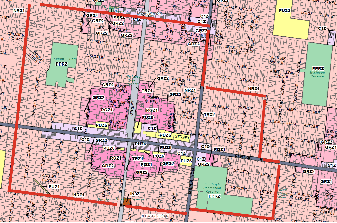
Featured below is an image detailing the potential outcomes of what this government is planning for our suburbs. Most of the changes impact directly on our quiet residential areas and not necessarily on the commercial zoned sites.

In order to demonstrate the extent of these proposed changes, we’ve produced an image which is based on the current state of play as per our planning scheme. Added to this image, we’ve outlined in red the areas that are now considered for ‘upgrading’ by this government.

Please note carefully:

  1. The size of the new ‘borders’ that include countless properties that are zoned NRZ1 – ie height limit of 2 storeys. They will now ALL be available for 3 storeys and if on large sites, the height limit becomes 4 storeys.
  2. Many of these sites also are heritage listed, or under a Neighbourhood Character Overlay. Our previous post commented on the lack of clarity as to how heritage sites will be protected under the proposals.
  3. Government has now removed the need for visitor car parking. Hence, the possibility of three storey apartment blocks everywhere, with no adequate onsite parking, turns our streets into parking alleys where residents and visitors will battle for parking spots.

The changes impact on probably a thousand sites in just this one activity centre. When this is combined with what is happening throughout the municipality, then it is probably quite feasible to envisage a future where well over 70-80% of our municipality is earmarked for much greater density comprising not townhouses but apartment blocks.

As has been said previously by us and commentators, no thought has been given to sustainability, infrastructure, open space, traffic, and overall quality of life.

If this future frightens you, then please make your concerns known to this council. Insist on some real fight, and full transparency in everything they are doing. Silence is consent after all!

Submissions on the state government’s latest planning travesties, close on March 22nd, 2026. Glen Eira council has put up several media releases encouraging residents to view the Engage Victoria website and hopefully, submit their views. Is this enough however? Interestingly, the February 2026 council media release concluded with this sentence:

We encourage everyone to learn more and share their views via the Victorian Government’s Engage Victoria website at www.engage.vic.gov.au/traintramzones.

Do residents really ‘learn more’ by reading the government spin? Do they achieve anything from a survey that is unashamedly geared towards confirming proposed planning changes? If we are correct in characterising the Engage Victoria exercise as nothing more than another sham consultation, then what is, and should be, the roles of councils?

Should councils, cut through the spin and provide residents with:

  • A clear summary of proposed height changes for all activity centres nominated?
  • Debunk government claims when and where appropriate?
  • Provide clear statements as to the impact of proposed changes on heritage, environment, sustainable development, traffic, infrastructure, open space, economy, density, and scores of other potential impacts?

March 22nd is literally days away and we are yet to see council’s submission. On Tuesday there was a council meeting. Why was there no submission presented? Does this mean that residents will not be privy to the submission that is eventually submitted? Or will we be shown this submission only after it has already gone in? Why can Stonnington get off its backside and produce a superb submission that was tabled at their March 16th council meeting?  Given that councils have had plenty of warning as to closing dates, why haven’t we seen anything from Glen Eira?

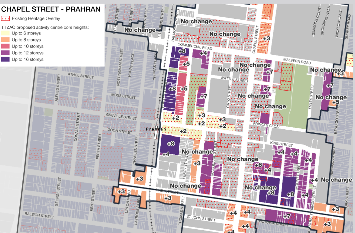
What we find as particularly impressive about the Stonnington submission and its information sharing with the community is the series of maps which show residents exactly what is proposed. Here is one of these maps:

It is difficult to be any clearer than the above. Residents can immediately see the current planning controls regarding the increases in proposed heights. In Glen Eira none of this has really been spelt out for the community.

Stonnington has also engaged its own consultants to do 3D planning analyses, as well as breaking down how much of their municipality is likely to be changed. They claim that 70% of Stonnington will covered by the activity centre planning proposals. When one looks at what is proposed for Glen Eira we think that it is even higher for our municipality. Will Glen Eira even bother to do this work to ‘inform’ residents? We doubt it!!!!!

Finally a few quotes taken from the Stonnington March 16th submission and the accompanying officer’s report –

The proposed heights exceed those established within Stonnington’s existing strategic work as shown in Council’s height comparison maps at Attachment 3. This is likely to impact the heritage significance and character of our historic streetscapes, undermine pedestrian scale, reduce sunlight to streets and parks, and detract from residential amenity.

An alternative extent and application of Housing Choice and Transport Zones (HCTZ1 and HCTZ2) is recommended based on local conditions. Stonnington’s approach excludes areas with heritage and neighbourhood character overlays, and alters the application of the HCTZ (from HCTZ1 to HCTZ2) to existing and proposed Neighbourhood Residential Zones (NRZ) in the Housing Strategy

There is a disconnect between the stated objectives of the Activity Centres Program and the Stage 2 maps released for consultation. No modelling, testing, sight line diagrams or analysis has been provided to demonstrate how these maps meet these design principles. It is unclear what setbacks would apply to street and residential interfaces to manage adverse impacts associated with tall buildings. Council’s modelling shows some of these principles, such as ‘sunny streets’ cannot be met by the heights proposed

State Government’s Activity Centres Program has been progressed over a short timeframe by using a consistent approach across metropolitan Melbourne to activity centre planning. As a result, their maps are not adequately tailored to local conditions.

Nor are they informed by an evidence base, such as built form modelling and testing that provide an understanding of heritage impacts, sunlight access, wind, views from the public realm and neighbouring sites

The State Government’s Train and Tram Zone Activity Centres (TTZAC) Program (including the Chadstone pilot centre) affects a large proportion of land within Stonnington – as shown in the adjacent figure. Approximately 70 per cent per cent of Stonnington is impacted.

In the absence of growth targets per centre, it is unclear if the level of change proposed is purposefully (and effectively) meeting this stated outcome. Transparent targets would provide a baseline understanding of how much housing, employment and services the areas need to accommodate over time. Without this context, decisions about building heights and density and infrastructure upgrades risk being ad hoc or misaligned with the needs of the community and may not take into account the existing development that has occurred across these major centres

The proposed inner and outer catchments include highly valued heritage precincts with some of the most substantially intact, consistent Victorian, Federation and interwar housing in Stonnington. Approximately one third of the properties within the residential area proposed for the Housing Choice and Transport Zone (HCTZ) with increased heights is covered by a Heritage Overlay or a Neighbourhood Character Overlay. Most of these areas along with residential streets of consistent character are currently within the Neighbourhood Residential Zone or General Residential Zone with a 9m height limit (2 storeys), whereas heights of between 3-6 storeys will now be allowed.

Whilst the State Government has stated that existing Heritage Overlays will remain in place with planning permit triggers and assessment unchanged, the proposed controls create an inherent tension by establishing an underlying zone promoting higher growth.

The existing NRZ includes this relevant purpose ‘To manage and ensure that development is responsive to the identified neighbourhood character, heritage, environmental or landscape characteristics’ which will no longer apply when it’s rezoned to the HCTZ.

The areas identified for increased density and growth (Housing Choice and Transport Zone) appear to apply blanket zoning changes without any clear justification beyond distance to the centre. The inner catchment has been applied to areas adjacent to the centre regardless of clear constraints such as Heritage Overlays, Neighbourhood Character Overlays and flooding risk.

Stonnington’s adopted Housing Strategy has considered building heights within the catchments, and provides a context-responsive approach, allowing for realistic levels of growth based on existing constraints and opportunities.

Council considers that all areas where precinct Heritage Overlays or Neighbourhood Character Overlays apply, should be removed from the proposed inner or outer catchment.

The Government’s latest planning move has now been made public . In typical style it is the media that is informed first, rather than the community, or we assume even councils.  Maps featuring the remaining activity centres such as Caulfield and Glen Huntly feature in The Age. Bentleigh is also mentioned, but the media has not provided the maps for this activity centre.

We could not find any maps on the various government websites apart from a media release by the Premier. No link was provided to the maps.

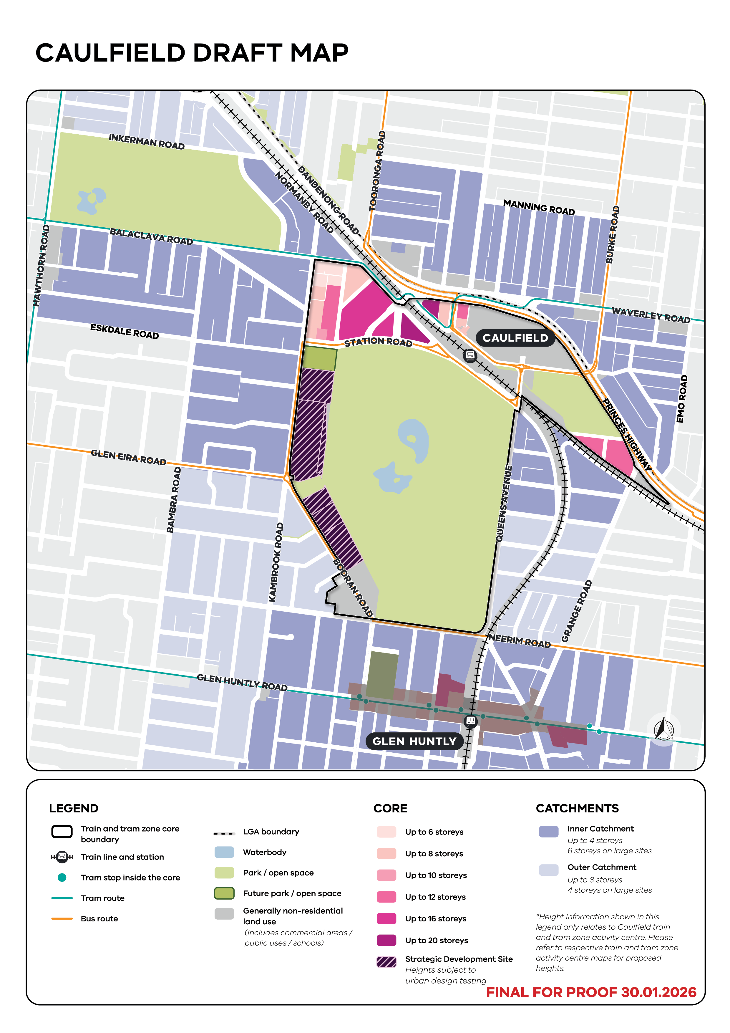
Here is what is proposed for what is euphemistically called Caulfield even though it covers most of Caulfield North, Caulfield East and Caulfield South. Please note:

  1. The dark brown areas designated as ‘strategic development site’ with no height limits announced. The MRC must be laughing all the way to the bank!
  2. The expansion of the ‘inner catchment’ all the way to Hawthorn Road, with the possibility of up to 6 storeys on ‘large’ sites .
  3. Three storeys along major roads such as Bambra and all the way to Balaclava.

Another example of planning that has the potential to destroy what most communities regard as sacrosanct – heritage, sunlight, environment, etc. etc. And whether or not any of these planning moves actually achieve affordable housing, or even sustainable housing is highly questionable.

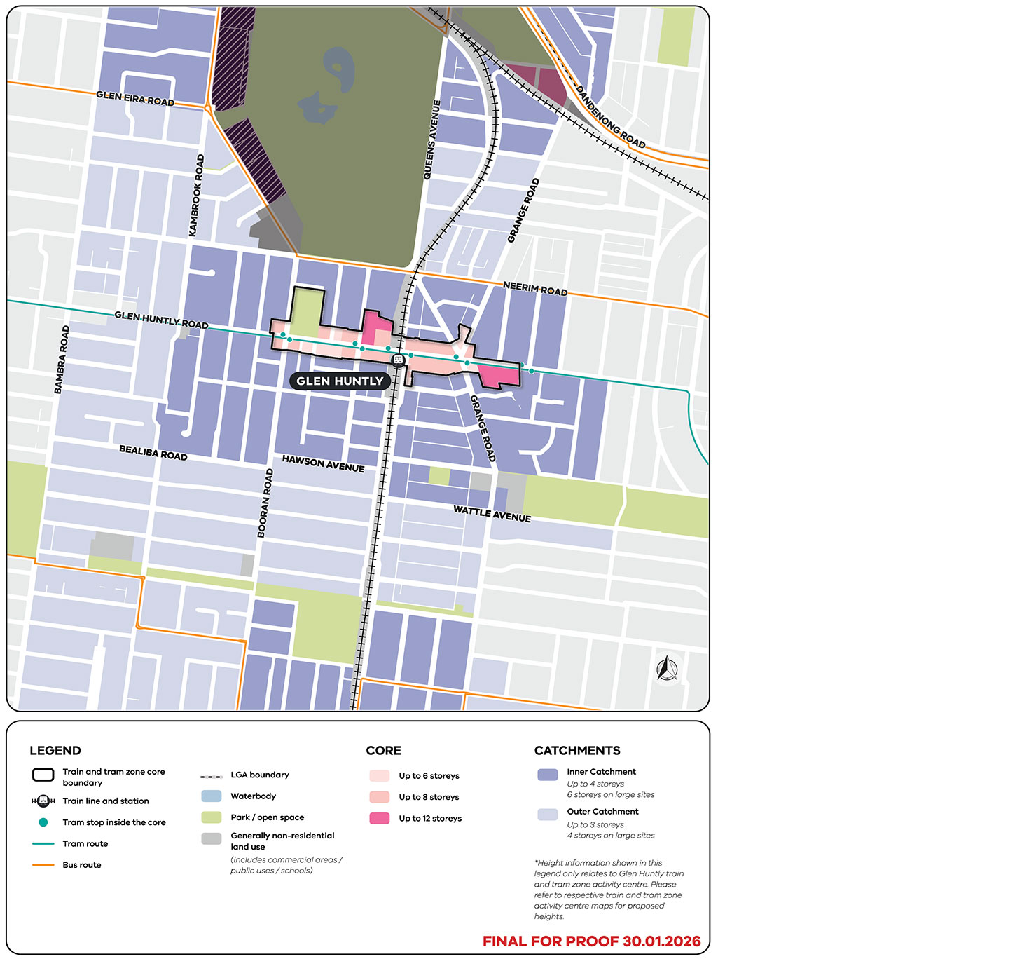
And for good measure, here’s Glen Huntly

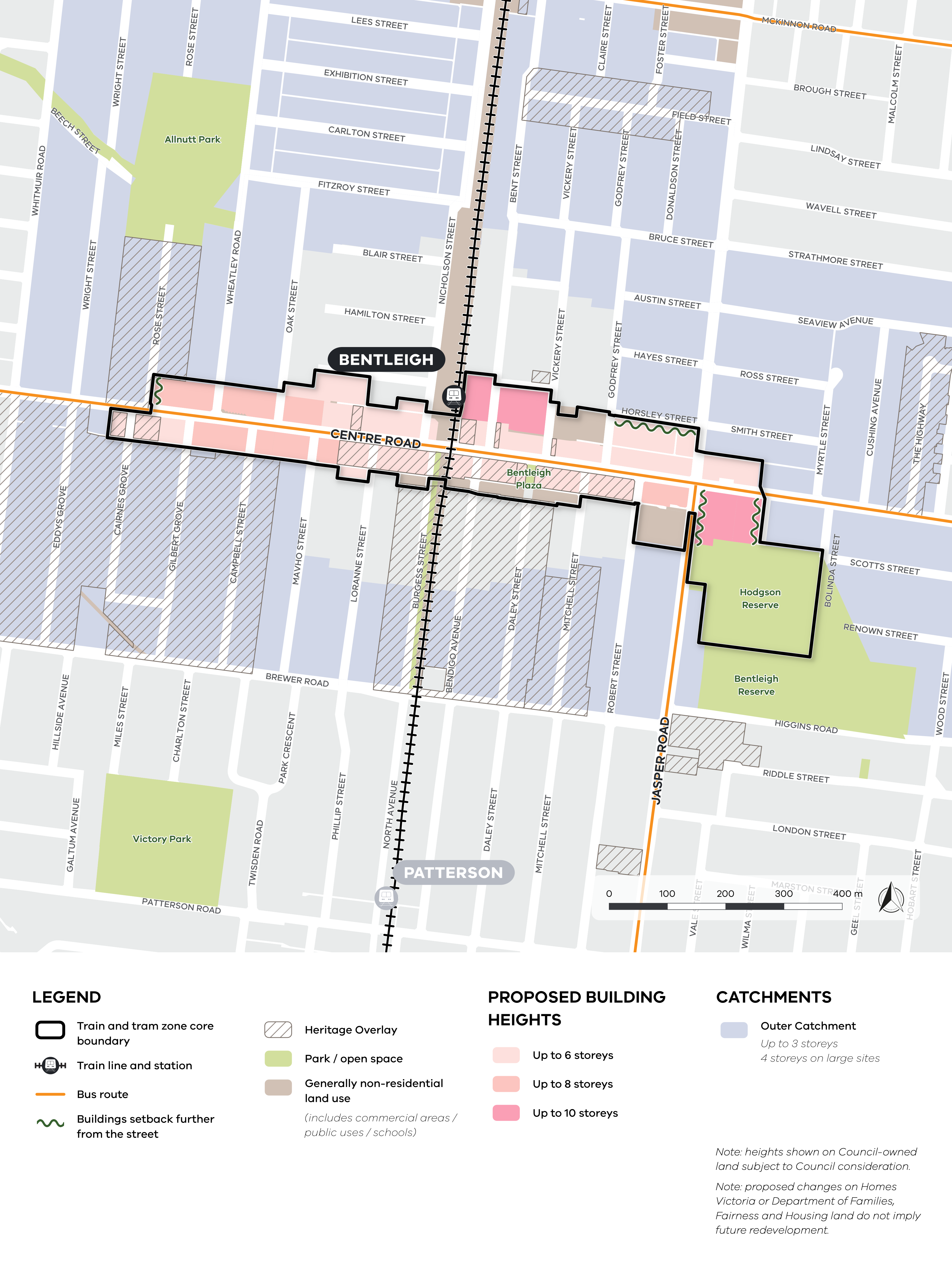
PS: finally found a link to the latest ‘survey’ on these Phase 2 activity centre announcements. Below is the Bentleigh one –

The accompanying survey for Bentleigh is another sham exercise in ‘community consultation’. In regards to the proposed heights of up to ten storeys, the question regarding this is:

What range of heights do you think are suitable for the core of your area? Required

6 – 8 storeys

8 – 10 storeys

10 – 12 storeys

Greater than 12 storeys

No opportunity provided in the above question to even object to the 6 and 8 storey height limits. Before the ability to move on to another question, you are ‘required’ to select one of these options.

Another question which leaves much to be desired is – Where do you think the proposed highest building heights in the core should be located? Required

Most of the ‘survey’ is nothing more than motherhood statements. This isn’t consultation. It is an exercise to provide us with answers that basically support what is proposed!

Finally there is some commentary from Glen Eira on the state government’s proposed changes to all activity centres – especially the inclusion of expanded areas surrounding these activity centres. Once again, the proposed submission by Glen Eira palls into insignificance compared to the efforts produced by Boroondara and Bayside. These councils have held public forums, Q and A sessions, and prominently featured summaries and information on their websites. Glen Eira has done none of these things.

So now we come to the need for a formal submission by late October. We have read the submissions and copied verbatim some of the comments contained in the various officer reports. Whilst the final submission(s) have as yet to be written, the amount of detail provided by Boroondara compared to Glen Eira is staggering. What’s also insightful is the tone that each council applies. Boroondara sees nothing wrong with clear and unequivocal criticisms. Glen Eira on the other hand resorts to wishy-washy statements that basically mean nothing. Boroondara is also not averse to publishing so called ‘confidential’ documents. Glen Eira does not even mention the fact that they have received such documents!

Once more we have to ask why another council can produce work which informs the community with detailed analysis and Glen Eira can only produce some generic document that adds little to basic understanding of the potential impacts. Does it all boil down to the quality of our planning department? Or is this merely another instance of an administration that fully welcomes the government agenda and to hell with existing residents, liveability, heritage and a million other consequences?

Please read the following quotes carefully and realise how vastly different they read and what this actually means.

GLEN EIRA (16th October agenda)

Generally, not supportive of the “deemed to comply” approach for heights, setbacks and street wall heights which will be applied in the core and catchment areas.

In the core commercial area of Carnegie, the proposed changes are positive for Council and the community, with draft maps proposing to retain the building heights adopted under the Carnegie Structure Plan (proposed Planning Scheme Amendment C237). This is pleasing to see and the result of strong advocacy by Council over 2024 and 2025.

Council has continually requested that DTP provide technical reports/data as part of their activity centre program, plans and draft maps. This will help us understand how the heights were developed, modelled and what was considered.

Council’s experience with the deemed to comply approach in the Moorabbin and Chadstone activity centres, is that Council is limited in its ability to encourage increased development within the catchment areas, where appropriate. This is due to the changes which essentially switch off policy and zone purpose considerations for townhouse development. The intent of the catchments is therefore not being achieved in these existing locations and Council is likely to see a similar result in the Carnegie Cluster unless changes are made to the planning controls.

The heights for Murrumbeena and Hughesdale core areas and for all the catchment areas are a significant change, particularly in the outer core areas. These proposed heights are contrary to the heights adopted in the Glen Eira Housing Strategy and a departure from the community’s expectations

It is unclear on how the catchment areas will integrate with the heritage places and precincts and Neighbourhood Character Overlay (NCO) in these areas, specifically in Carnegie and Murrumbeena. If the BFO and HCTZ are applied these controls will allow taller built forms in potential conflict with neighbourhood character and heritage streetscapes.

Directing housing into existing activity centres will reduce the impacts of significant growth on the environment in growth areas. Living more closely together can open opportunities for the sharing economy, increase local services and reduce the need for travel, and enable more people to live close to public transport

These changes coupled with the other recent changes to housing assessment provisions creates a substantially different planning context for Glen Eira and the community

OFFICER’S REPORT – 13 PAGES

BOROONDARA (6th October minutes)

The draft standards have been circulated on a confidential basis and are not available for public distribution. This approach limits transparency and prevents meaningful community input. For proper consideration, the draft standards should be formally exhibited and open to feedback from the community

The introduction of new and improved standards for developments of 4–6 storeys is needed as it is recognised that larger built forms have the potential to generate greater visual bulk, overshadowing and amenity impacts compared with smaller developments. However, a number of the proposed standards reduce and weaken the existing requirements, particuarly relating to off-site amenity impacts such as overshadowing and overlooking

Through amendments VC243 and VC267 earlier this year, Clause 55 of the planning scheme, which relates to residential development up to 3 storeys, was amended to lower the standards and make them ‘deemed to comply’. This means that where the standard is met, the objective to the standard is automatically met. Developments that comply with the deemed to comply standards in Clause 55 are also exempt from third party appeals (objector reviews of a decision) to the Victorian Civil and Administrative Tribunal.

Key changes to Clause 55 and 57 at the time included:

• The minimum street setback requirement reduced from 9 metres to 6 metres.

• The private open space requirement reduced from 40 square metres to 25 square metres at ground level.

• Site coverage requirements have been revised to include a sliding scale dependant on which zone the site is located (60% Neighbourhood Residential

Zone and Township Zone, 65% General Residential Zone and 70% Mixed Use Zone and the newly minted Housing Choice and Transport Zone).

• Overlooking standards no longer apply to bedroom windows.

• Options for two side and rear setback standards.

The submission will highlight the following concerns:

• Front setback changes will increase the dominance of buildings in the streetscape and reduce opportunities for tree planting in the front setback to one small or medium tree.

• 4 to 6 storey proposals are able to access a lesser street setback than 1 to 3 storey proposals. This may have a consequence of encouraging proposals with a greater height in the HCTZ compared to lower scale proposals such as townhouses.

Allowing bedroom windows to have a sole source of daylight to a light-court, instead of an external wall of the building, is considered to be a poor amenity outcome for the future occupants. It is inapt that a bedroom window is proposed to be afforded with the same level of amenity as a non-habitable room window such as a bathroom or laundry. It is considered that bedrooms should be included in Building Separation, which would improve the overall amenity of dwellings. At a minimum, daylight modelling should be required if light-courts are to be relied upon as a bedroom’s only source of daylight access

The draft mid-rise standards suggests that the proposed side and rear setback requirements effectively limits overshadowing impacts on adjoining properties, in a similar way to applying the existing overshadowing standard and protects neighbouring development opportunities. No modelling has been provided to demonstrate whether the outcome will offer less or equal protection and it is suggested that existing protection should not be reduced.

Sustainability considerations will maintain existing standards for permeability and stormwater management as well as energy efficiency. A level of documentation would be required from applicants to demonstrate compliance with cooling loads, but this would be the extent of assessment. With the operation of standards narrowing considerations, there will be a reduction in assessment of Environmentally Sustainable Development (ESD) features in development outcomes compared to what is currently offered with planning applications. This is contrary to the ambition to elevate ESD targets and draft standards fail to recognise the opportunity to embed stronger environmental sustainability measures within mid-rise apartment development which will be raised as a concern in the submission.

However, the draft has been circulated on a confidential basis and is not available for broader distribution (Attachment 1 confidential). It is unclear why the draft has been circulated on a confidential basis as there is nothing of a confidential nature within the code. The standards are very similar to the standards that have already been introduced to the planning scheme for other residential development types, such as the townhouse and low rise code, so there are no concepts being tested with Councils and stakeholders that are not already publicly available. Even if new concepts are being tested for stakeholder input that are potentially controversial or sensitive, that does not make the material “confidential”.

Officer’s report – 22 pages

BOROONDARA (10TH October)

The ACP’s rushed rollout and extremely compressed timeframes, the absence of evidence supporting the need for urgency, and disregard for proper planning processes – including transparent policy development and authentic consultation – have eroded public trust and accountability in its implementation

Another key methodological flaw to be highlighted is the lack of coordination and integration with other planning investigations that will have significant impact on the development capacity of the identified centres. Most notably the absence of updated flood mapping (not expected until late 2026), no provision of a comprehensive movement and place analysis and framework and no plan for place based and community infrastructure to support growth and deliver high density urban amenity.

General issues, inconsistencies and problematic outcomes include:

• Lack of justification for the density index approach to set the baseline for building heights and catchment distances as well as the methodology on how the density index was applied to centres.

• The lack of evidence (including urban design analysis and built form testing or modelling) to support the building heights across the centres.

• Lack of justification to exceed the 8 to 12-storey maximum set for Centres with a density index of 3.

• Excessive building heights resulting in overshadowing of footpaths in key locations contradicting principles of creating high quality, pedestrian-focussed public realm.

• The inconsistency in applying different building heights to adjoining sites with the same context and interface issues.

• The lack of building heights for identified strategic heights and failure to define how strategic sites were selected.

• Building heights not responding to sensitive interfaces such as low-rise heritage areas (e.g. Manningtree Road, Hawthorn).

• Applying uniform building heights across larger strategic sites where differential heights, setbacks and place-based built form response is required

Inclusion of heritage areas within the catchment. One of the most critical issues to be highlighted in the submission is the inclusion of heritage areas within the residential catchment (e.g. Grace Park Estate, Cranmore Estate and Environs amongst others). Apart from the inappropriate impact this would have on our city’s valued heritage areas, applying the inner catchment to heritage is inconsistent with DTP’s methodology described in the additional technical information and the approach taken in the pilot program. Applying a catchment growth area to any heritage area is inconsistent with the findings and recommendations of the Activity Centre (Pilot program) Standing Advisory Committee.
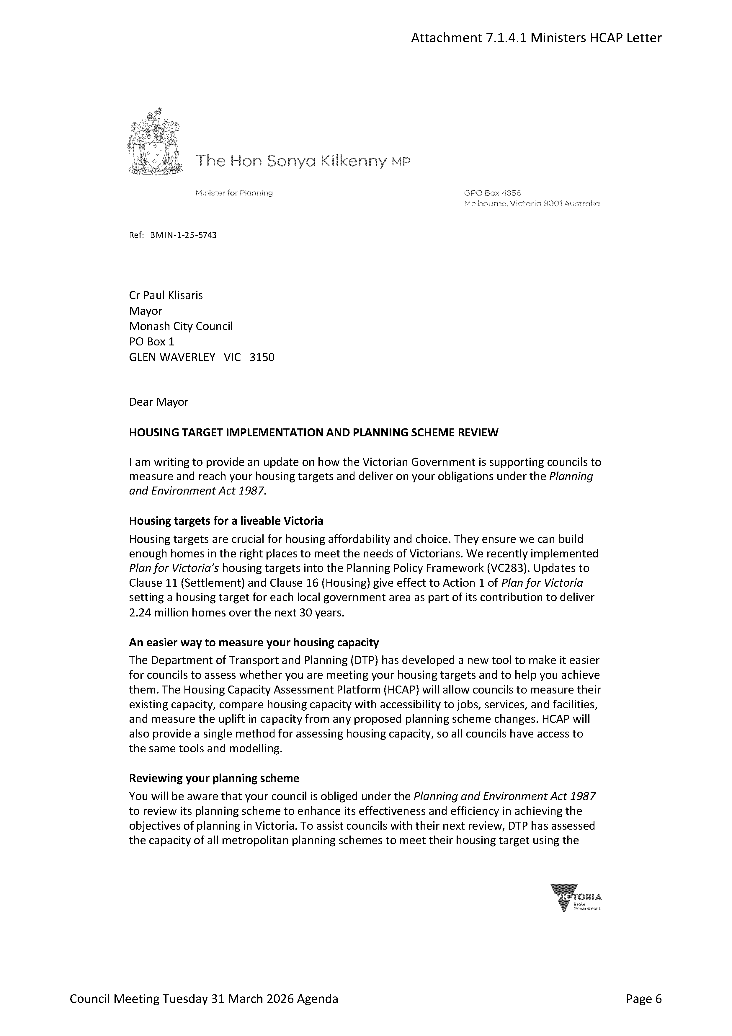
Indeed! – why the silence from Glen Eira council? Why can other councils go public and voice their strong opposition to the state government’s ad hoc planning agenda that lacks strategic justification, genuine consultation, and full transparency? Why can other councils’ websites include valuable summaries of the current state of play, plus links to relevant government documents and surveys? Nothing like this exists for Glen Eira residents who have much to lose given that we have 9 railway stations, and 13 nominated activity centres.

The latest outrage is featured in this Age article. Please note the stance taken by Boroondara and their officer’s (public) report.

Mid-rise developments could loom over suburbs, secret documents reveal

By Lachlan Abbott

Mid-rise apartment developments could loom closer to heritage homes and overshadow solar panels, under confidential Victorian draft planning guidelines.

The Department of Transport and Planning is finalising new “deemed-to-comply” design standards for four- to six-storey residential developments that would exempt proposals from time-consuming appeals.

Camberwell resident Jane Oldham worries mid-rise apartment design will worsen under the new code and harm Boroondara, where heritage homes are prevalent.

The draft rules were recently shared with councils for feedback in a document marked confidential, but Boroondara Council revealed details at a meeting on Monday night.

Jane Oldham, of the Boroondara Community Group, spoke at the meeting against the draft standards, which propose approval for street setbacks of 4½ metres, lower than the already reduced six-metre requirement under the low-rise code announced earlier this year.

Oldham was concerned that the changes would lead to mid-rise buildings jammed together, reducing privacy, sunlight and green space.

“Why people like suburbs such as Camberwell, I think, is the heritage, the character, the greenery,” Oldham said. “And that will definitely be lost. We can do better.”

The Allan government has argued the mid-rise code would make the planning system easier and boost housing supply while maintaining amenity.

The standards have not been finalised.

In a statement, Boroondara Mayor Sophie Torney said the broader community deserved honesty and criticised the state government for keeping under wraps the options that have been canvassed.

“Boroondara believes in open, transparent decision-making,” she said. “Communities have a right to know what’s being proposed in their own neighbourhoods before decisions are made, not after.”

Boroondara Mayor Sophie Torney says the state has ignored locals in their plans for the Hawthorn, Glenferrie, Auburn and Kew Junction activity centres.Credit: Eamon Gallagher

The new mid-rise code is most applicable to the Housing Choice and Transport Zones in Melbourne’s 60 new activity centres, which are slated for four- to six-storey development.

Affluent eastern suburbs are overrepresented in the state government’s activity centre program, as the state government says outer suburbs have shouldered too much of the home-building load in recent decades. The only way to make housing fairer for young Victorians is to build more homes faster,” a state government spokesperson said. “This is exactly why we’ve been overhauling our planning system, because the status quo is not an option.”

Boroondara is among several councils that have strongly criticised the approach so far.

On Monday night, Torney expressed particular concern that the proposed mid-rise standards did not have a clause to prevent buildings from blocking sunlight to solar panels, which was included in the low-rise standards announced earlier this year.

“We’re literally building shadows over the very homes we want to electrify, and not ensuring new apartment builds potentially have solar,” Torney said.

“That makes no sense to me, and it’s in direct contrast to the government’s energy policies.”

In their submission to the government, Boroondara council officers also took issue with a proposal to deem bedrooms compliant if their sole sunlight source was a window facing an internal-light courtyard, rather than an outward-facing window.

The proposed 4.5-metre setback standard also caused consternation, as the council said it would incentivise higher development while the minimum low-rise setback was six metres.

“The irony at the moment [is] under the existing scenario for a single dwelling, it has to be further back again,” Boroondara’s urban living director Scott Walker said on Monday.

“Now that’s going to get changed … but we’ve got quite a paradoxical standard scenario at the moment.”

Whitehorse City Council also expressed “significant concerns” about the draft mid-rise standards at a meeting in September.

Planning Institute of Victoria president Pat Fensham, having viewed the mid-rise code proposals in the Boroondara council document, said he was also concerned there appeared to be no provision for councils to consider local design issues.

He argued this meant site-specific environmental problems could be missed under a narrow assessment of whether a mid-rise proposal was “deemed to comply” with built-form standards.

“You can’t anticipate all the impacts. Local context matters,” he said.

YIMBY Melbourne lead organiser Jonathan O’Brien, whose group has urged governments to address “the missing middle” of housing development, supported the state government’s overall approach when he viewed the proposals detailed in the Boroondara council documents.

“We see codification like this, even if it’s imperfect, as an absolute improvement,” he said.

Source: https://www.theage.com.au/national/victoria/mid-rise-developments-could-loom-over-suburbs-secret-documents-reveal-20251007-p5n0mv.html

The State Government has now released the next swathe of planning interventions for 25 activity centres. Whilst it may be argued that Glen Eira does slightly better than Bayside or Boroondara in terms of height limits, the overall impact of the proposed changes are catastrophic for residential amenity and urban living.

At the time of writing, we have not sighted any response from Glen Eira on their website. In contrast both Bayside and Boroondara were quick out of the blocks in condemning this latest intervention. See: https://www.bayside.vic.gov.au/news/statement-activity-centres-program-consultation

and

Once again there is nothing in these newly released documents which provide any information on: infrastructure costs, traffic, open space, etc. All we’re told is that developers can now build to their heart’s content and bypass resident objections in most cases. Even the government run consultation surveys are again nothing more than a tick the box exercise (see the Boroondara link for access details). We are still to see what plans are in store for Bentleigh, Elsternwick, Glen Huntly and others.

It is indeed extreme folly to believe that what will eventuate will be affordable housing. These inner suburbs basically cater for ‘luxury’ apartments selling between $2m and $3m or dog boxes that in no way suit a family.

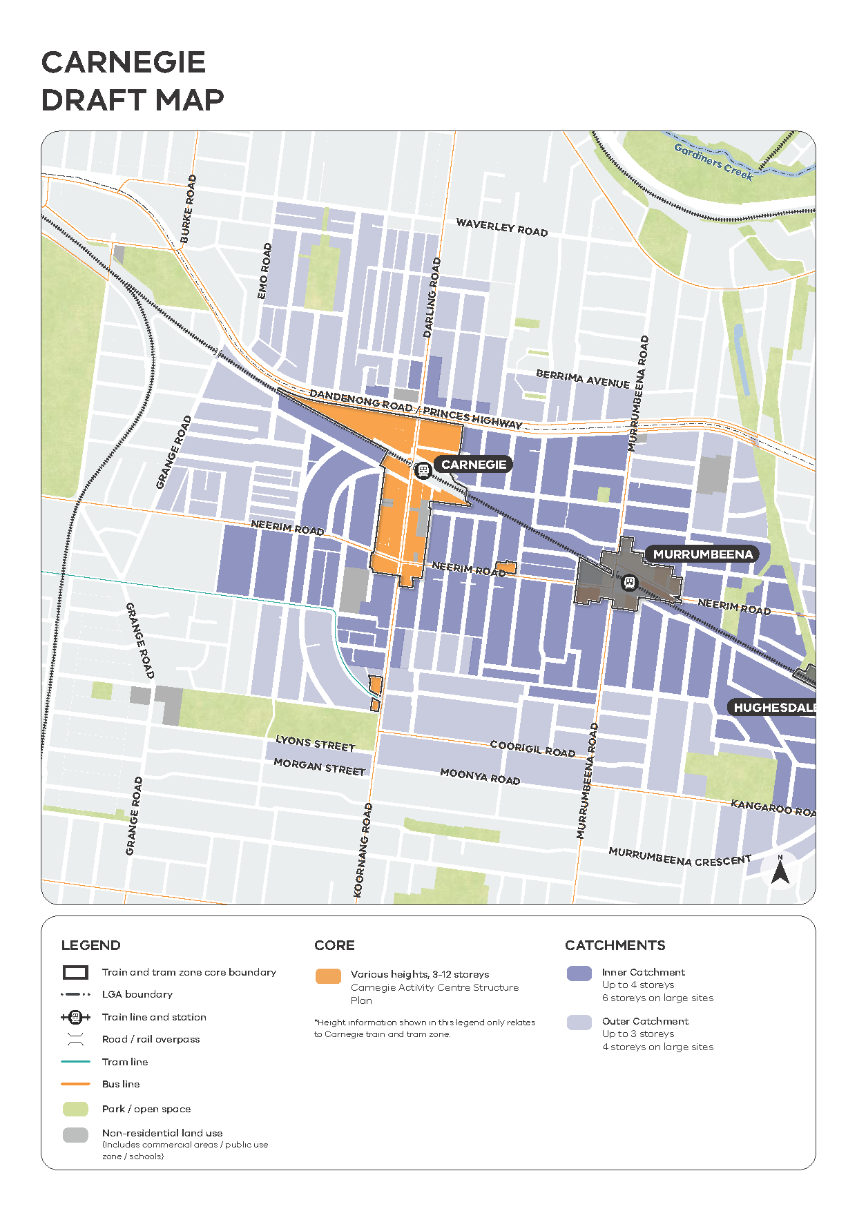
Here’s what is proposed for Carnegie –

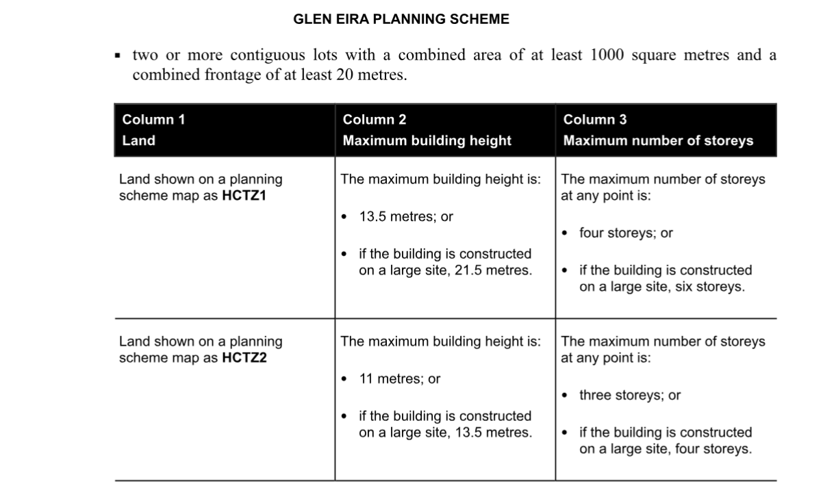
Whilst the council structure plan remains the same (and already includes allowance for 12 storeys) the surrounding areas are severely impacted. Please note that the light blue sections in the above image can now be built to 3 storeys and the darker blue to 4 storeys. If the land is ‘large’ (and this isn’t defined) then the limits go to 4 storeys or even 6 storeys.

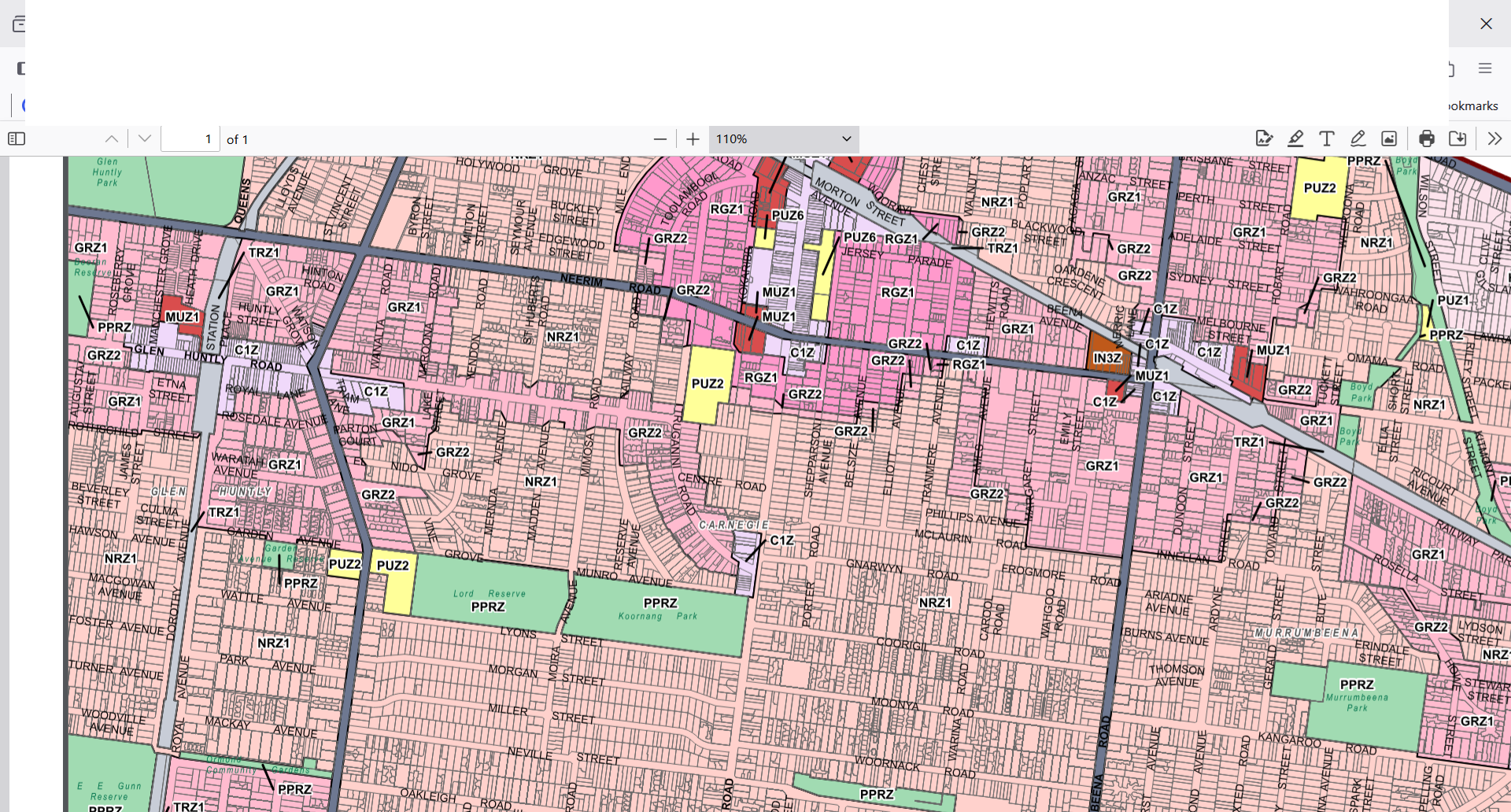
When this is compared to the current zonings, then hundreds upon hundreds of sites are being earmarked for height increases and therefore a massive density rise. For example here are our current zonings:

  • All the areas shown as light pink in the following image are currently zoned as NRZ (neighbourhood residential zone) meaning they are either single or double storey dwellings. They can now become 3 and 4 storeys if they are on an average 500 square metre site, or if larger, the option is to go to 6 storeys.
  • There are very few 3 storey town houses, which means that most developments will consist of apartment blocks and not town houses. Besides, building an apartment means that more dwellings can be squeezed in compared to town houses.

What we are witnessing is the creation of unsustainable development that will become an urban wasteland that consists of apartment blocks following apartment blocks with no regard for heritage, open space, environment, and certainly no cheaper housing that suits families and downsizers. If our councillors aren’t screaming blue murder right now, then they are not doing their jobs in representing their constituents.

There are only two possible conclusions to be drawn from Glen Eira council’s submission into the state government’s select committee review of recent government planning amendments – either our planning officers are entirely incompetent or, they are basically on side with the proposed changes and therefore will not be as critical as they should in their dealings with government.

Yes, council in its submission addresses what most other councils point out:

  1. The removal of third party objection rights
  2. The lack of consultation and release of documents that justify the proposed changes
  3. The ungodly haste of these changes
  4. The lack of infrastructure funding information

But that’s where it stops. The failure to highlight, or even mention some of the following is inexcusable –

  • The increasing control of the Minister over planning permits
  • The reduction in private open space everywhere
  • The failure to ensure that tree canopies will increase
  • The destruction of local residential amenity
  • Heritage, environment, flooding, and neighbourhood character in general
  • Housing targets compared to Victoria in Future figures

Here was an opportunity to delve deep into the consequences of these amendments and show how they will change the face of Melbourne forever if they become ‘law’. This council failed to do. Instead all we got were largely minor criticisms of wording, their ambiguity, and the ‘risks’ this presented to council – not the community at large!!!!!

For starters, please compare the Glen Eira’s overall interpretation compared to other councils. Note the tone!

…. it is way too early to make a call on whether these amendments will result in more housing being built and whether the type of housing that will be built will be affordable and meet the diversity needs of home seekers. The question as to whether the three amendments give proper effect, to the objectives of ‘planning’ and the’ planning framework’ in Victoria is, to some degree, considered premature.

BAYSIDE – The change that could occur through the Amendments should not be underestimated. It has the potential to very substantially change the face of Melbourne because of how large the affected areas are. None of this is consistent with the “fairness” objective of planning in Victoria.

STONNINGTON – Stonnington was disappointed that these amendments were largely announced through the media, representing major urban planning and public policy by stealth, which risks poor long term liveability outcomes for residents.

KNOX – Knox officers do not believe that the proposed provisions will achieve better design outcomes and as drafted, are not fit for purpose and risk a range of unintended consequences

MAROONDAH – A key assumption behind recent changes to the VPPs is that having a standardised approach to development across Victoria will deliver an increased number of dwellings. With the attempt to standardise development types in activity centres, as well as the deemed to comply approach for Rescode ……to encourage and approve development that responds to local amenity, place and neighbourhood character is now a thing of the past

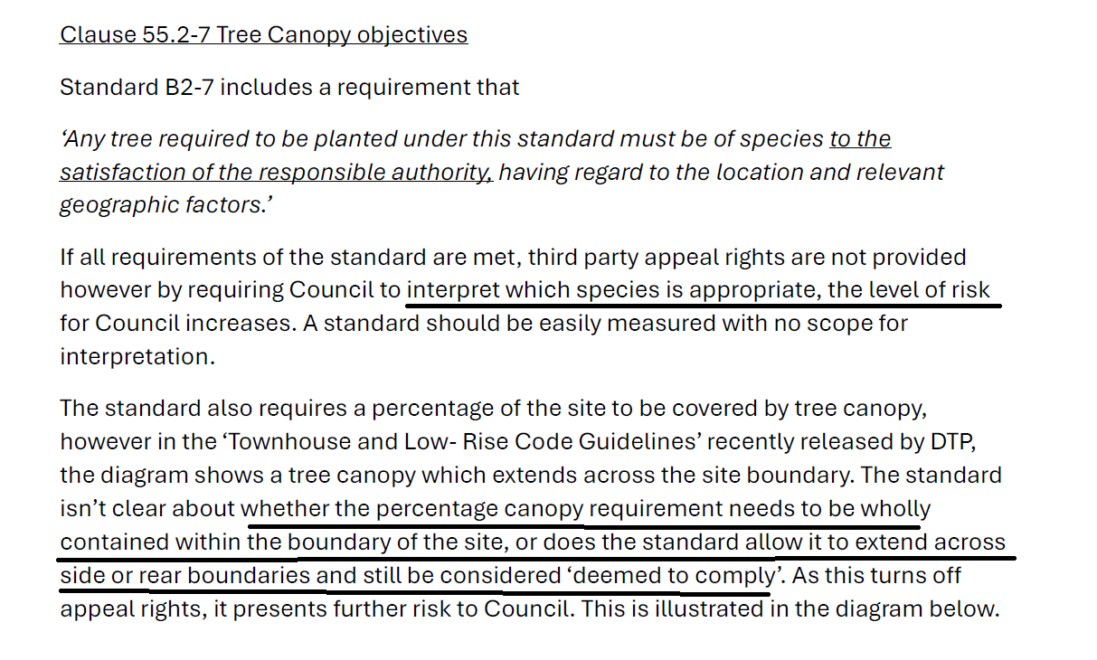
The majority of other councils concentrated heavily on the impacts of the removal of their existing residential zone schedules and what this would mean in terms of reduced open space availability given the increased site coverages and its effects on tree removal and protection of tree canopy targets. For instance, Glen Eira currently has a 50% coverage in its residential NRZ1 zone. This will now be 60% with a reduction in private open space requirements, front setbacks reduced to 6 m instead of current 9 metres. There are other mooted changes that will impact horribly on local streets and neighbourhoods throughout the municipality. So what is Glen Eira’s response to these threats? Please read the following extract carefully –

No mention is made of how this might affect tree canopy targets, nor whether the increased site coverage could simply result in larger dwellings. What’s even more amusing is the continued emphases on ‘risks’ to councils. But it has always been up to council to determine the appropriateness of landscaping. This hasn’t changed..

Here are the views of some other councils –

STONNINGTON – New requirements require a minimum of 10% canopy cover for sites 1000 square metres or less, and 20% for sites over 1000 square metres. The majority of residential lots in Stonnington are less than 1000 square metres. 10 per cent canopy cover will not raise greening to reach the target identified in Plan for Victoria and is significantly lower than what is currently being provided in new developments throughout residential areas in Stonnington.

The one-size-fits-all approach of codified design standards will discourage high quality architecture in favour of cookie-cutter development that is not site responsive

Further evidence of the piecemeal approach to planning currently occurring in Victoria is the fact that none of the VC Amendments make any reference to either Plan Melbourne 2017-2050 or the belated announcement of Plan for Victoria.

BOROONDARA – The 10% canopy cover target is also inconsistent with the 30% canopy cover target contained in Plan for Victoria and significantly lower than Boroondara’s own target of 27%. In established areas the 10% canopy cover will often be less than currently exists so development will result in a reduction. This places too much onus on public land to make up the shortfall and achieve the tree canopy target.

Removal of environmental considerations is highly concerning. The deemed to comply nature of the Code means that local planning policies designed to achieve better environmental outcomes (i.e. Environmental Sustainable Design and tree protection) will be removed from consideration. Where a development is deemed to -comply only the minimal environmental considerations within the Code can be considered. This is highly problematic and not consistent with the delivery of future housing which is sustainable and reduces energy use for future residents

MAROONDAH – Removing the locally varied Clause 55 standards in the schedule to the zones as well as reducing the number of standards that could be varied in future, is more about the State s intent to maximise building footprints which often equates to larger homes, and not additional dwelling numbers, as opposed to achieving well designed dwellings that are site responsive designs that respond to the local amenity and conditions. There has been no evidence published by the State as to why the removal of local variations or how the new Code standards are necessary to meet housing targets..

Finally a summation of what these changes will mean for residents.

KNOX – Removing neighbourhood character consideration means that a development in Boronia or Ferntree Gully is assessed in the same way as a development in Elsternwick or Richmond.

New residential development in Knox, along with the rest of Victoria, will become a homogenous cookie‐cutter outcome that bears little relationship to its surrounding neighbourhood MAROONDAH – This flawed approach will result in all dwellings in Victoria being constructed to the same standards and design outcomes with no consideration of local context and character.

It has not been adequately evidenced by the Victorian Government as to how the revised Code will provide the capacity to deliver more housing. Expanding the building footprint permitted, reducing open space requirements and allowing dwellings to be larger, taller and of cheaper quality building materials, does not necessarily result in more or better housing.

There is much, much more that could be said in regards to council’s submission. Overall, it fails dismally by almost completely ignoring the impacts on local neighbourhoods. Heritage does not even rate a mention, and neither does decreasing open space. Why other councils can focus on these issues and Glen Eira chooses to basically ignore them is the crucial question.

We urge readers to acquaint themselves with the content of the various submissions. They can be accessed via this link – https://www.parliament.vic.gov.au/get-involved/inquiries/VPPamendments/submissions

Over the past week or so we have had announcement after announcement regarding the proposed changes to our activity centres. All bereft of strategic justification and lacking essential detail as to eventual heights, open space provision or infrastructure and its appropriate funding. We await the gazetting of other plans.

This tsunami of proposed changes will undoubtedly impact Glen Eira more than other councils and most will be without third party objection rights.

We itemise below each of these proposals –

Moorabbin

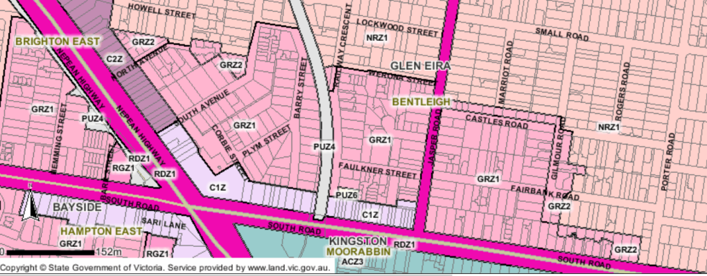
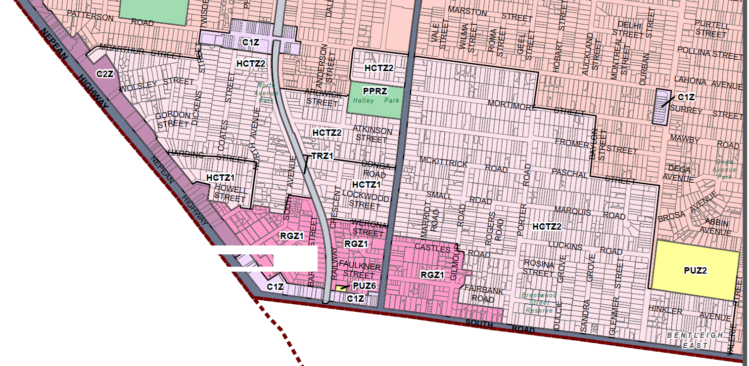
The changes to the Moorabbin major activity centre will affect Glen Eira in many ways. The latest version is depicted in the image below. Please note that Glen Eira sites feature north of South Road and north/east of Nepean Highway. The other areas included are within the Kingston and Bayside areas.

A summary of the most important changes are:

  • Catchment areas increased all the way from South Road to Patterson Road. Highly questionable whether this range is really 800m or simply as the crow flies.
  • The areas marked light blue are currently zoned as NRZ (ie two storey height limit). They will now be rezoned as suitable for up to three storeys and some four storeys depending on land size.
  • Most of the green coloured sites now have a three storey height limit which will be increased to six storeys.
  • Car parking requirements remain unknown

Thus hundreds of Glen Eira sites are impacted.

Railway Stations/Activity Centres

Yesterday’s announcement of another list of activity centres about to be changed forever has Glen Eira featuring prominently. We will now have 5 areas designated for major high density development – Bentleigh, Ormond, Glen Huntly, Elsternwick, and Caulfield. No other details as to heights, setbacks, parking, infrastructure, etc. has been released, nor most importantly what size their respective ‘catchment areas’ will be. We have no idea as to whether we are looking at 10 or 12 storeys (even though North Road has already been granted the ‘right’ for 10 storeys as this stage).

The only other council to have 5 areas nominated is Stonnington. What’s important to bear in mind is that Glen Eira is only 38.9 square km in size compared to most other councils. We also lack the commercial areas that Stonnington and other councils have – ie we are basically a residential municipality compared with the size of the commercial areas in other councils. (ie Glen Eira has 3.8% of land zoned commercial compared to Stonnington nearing 9%). With the prospect of all these areas suddenly becoming high density, this could mean that close to half of our municipality will now be a developer’s paradise. Glen Huntly currently has, according to profile.id data, a population density of 5,824 persons per square km – the highest in Glen Eira as well as being one of the smallest suburbs. Parts of our drainage system feature pipes that are 100 years old; our roads are often narrow, and congestion is already a major headache.

Equitable distribution of increased population planning does not seem to exist for this government. As long as there are railway stations, then the myth continues to be propagated that this is suitable for high density regardless of the fact that:

  • People living in one or two bedroom apartments still own cars as we’ve recently illustrated
  • More dwellings does not mean more affordable housing. When three bedroom apartments can sell for over $3m and two bedroom apartments for $1.4m then affordable housing is truly a myth in most of Glen Eira.

The tsunami of recent media releases by this government appears to mirror the Trump techniques – inundate readers with a deluge so that the ability to clearly focus, question, and assess becomes limited. Secondly resort to spin and more spin that simply makes no sense except to push a political agenda creating the impression that government is actually doing something.

Unless our council is prepared to become far more proactive and critical, as other councils have, then Glen Eira is basically doomed. It will, in our opinion, become the ghettos of either high priced luxury apartments, or our future slums with no real advance on affordable homes or protecting existing residential amenity.  

The most relevant and crucial point made at last night’s council meeting on the Woolies’ application came from Cr Daniel when she asked the following question. The audio also includes the response she received from the officer in charge:

How on earth it is possible to claim that the current application will not have any further ‘detriment’ on surrounding areas when:

  • A six storey building will now be ‘acceptable’ as a nine storey building with many changes to setbacks, balconies, reconfiguration of apartments, etc.
  • How is it possible to basically ignore almost completely the findings of the last VCAT hearing and claim that ‘on balance’ the crucial conditions imposed by VCAT can be ignored in favour of Woolworths?

What makes last night’s events even more unacceptable is the actual council submission itself. The last 3 pages of the submission list council’s recommendations. The final sentence states: Council does not object to the granting of a planning permit for application PA2403410, subject to the above recommendations being implemented. So what do these recommendations actually state? There is not a single word in these recommendations that have anything to do with the increased heights of both proposed towers nor the detailed findings of VCAT!!!!! The 3 pages of the recommendation consist entirely of commentary on such things as glazing, construction management plans etc. No recommendation is to be found in terms of heights, apartment reconfigurations, the impact on the proposed cultural centre and traffic movement etc.

Council does admittedly refer to the increase of heights in its first few pages. But these increases are largely seen in relation to council’s proposed structure plan via amendment C256 and how this new amendment reduced the existing 10 storey height to 8 storeys. Thus instead of objecting strongly to the woollies proposed heights as having a detrimental impact based on what VCAT found, the submission only refers to the newly proposed amendment and how the application  exceeds the 8 storey limit.  Given that both the 10 storey and now proposed 8 storey limit is ‘discretionary’, it will not be hard for Woolworths to argue that an increase in one or two storeys is okay if not ‘negligible’!!!!!!

Last night’s offerings especially by Karslake were indicative of what we consider to be the pro development agenda of this council. It is deliberately misleading for Karslake in her summation to present the issues against ‘rejection’ as a simple black and white dichotomy – ie we have to be in the game so rejection is not feasible! This does not mean that council’s submission could not have included some strong commentary urging the minister to reject the application based on previous findings and that if a permit was to be granted that the issues determined by VCAT be given serious consideration. This would not exclude the other recommendations made by council – but it would at least show strong support for community!

We’ve uploaded the full discussion on this item. Please listen carefully.  

We have repeatedly sought strong council opposition as to how the state government has been riding rough shod over councils. Glen Eira has largely been officially silent apart from a belated media release by McKenzie (who has now resigned!!!!) and some mealy mouthed submissions to various state run ‘consultations’. When compared to how Boroondara and others have acted recently we find Glen Eira’s responses woeful and a real desertion of their duty to residents. Here are a couple of paragraphs from Boroondara’s reactions last year to the imposed dwelling quotas for councils –

What Council is not supportive of is the additional ‘catchment area’ that extends a further 800m from the boundary of the centre and will allow for development height up to 6 storeys in heritage areas and low scale single dwelling leafy neighbourhoods. Neither Council nor the community have been consulted on this alarming new catchment area, which is illogical and representative of poor planning.

This vast catchment area encompasses 4,500 heritage listed properties. It is estimated that approximately 48% of this catchment area is land currently protected by the Heritage Overlay (refer to map provided). Council does not support this catchment area in any way and condemns the state government’s disregard for local heritage and amenity. This catchment area has been imposed with no evidence of any strategic analysis, assessment of local infrastructure capacity or consideration of the impact on local services and community facilities.

Any claims by the Minister for Planning that they have undertaken consultation with Council on the latest version of their plans are completely false

Source: https://www.boroondara.vic.gov.au/your-council/news-and-media/boroondara-news/councils-response-state-governments-latest-plan-camberwell-junction-activity-centre

« Previous PageNext Page »