GE Transport


Here’s what Magee said Tuesday night –

MAGEE: said he wanted to ‘show great respect’ to all those residents who put in submissions and showed up to the meetings. Claimed he was ‘very enthusiastic’ at the start about the review being a ‘great opportunity’ but ‘the more I read the report the more disappointed I became’. Although ‘I’ve never been a fan’ of structure planning he does ‘understand’ that this is a ’significant piece of work that planning departments do’. The time for it to be developed and its vision for 10 or 20 years is too long because he sees his Tucker ward area being ‘destroyed’ each day. So he is ‘so concerned and worried’ that ‘by the time we’ve done the structure plan it will be too late’. Claimed that ‘we know right now’ what is needed.

He had hoped to see the ‘neighbourhood character’ retained as with the 2013 Neighbourhood Character Overlays where ‘a whole host of properties’ were added to the list. Felt that ‘we should be concentrating more on Neighbourhood Character Overlays’ and Design and Development Overlays (DDO) rather than structure planning and controls which would ‘make VCAT actually apply those controls’ instead of merely ‘considering them’. Stated that ‘the minister has asked us to do this’ but our letter to him of last year asking of him ‘one single little thing’ – to change the law regarding VCAT ‘which would give us our protection’. Council wanted legislation so that ‘VCAT had to apply our planning scheme’. If this was done then 500 apartments ‘approved by VCAT’ wouldn’t have got through. So ‘that could have been one interim protection that could have been put in last year’.

With growing population of 1600 every year in Glen Eira and by 2031 a population of 170,000. ‘We can only put them up’ since we can’t spread out. The issue is then density and the pressure this is putting on commercial zones. ‘If we can’t have mandatory height limits as soon as possible’ then this issue ‘will drag’ on for the next 10 years. Council hasn’t ‘even addressed what’s going to happen to Virginia Park’ and the ‘railway corridors’. ‘We haven’t really addressed the transition’ zone issue especially in Bentleigh because this is ‘one of the only ones’ where commercial directly abuts Neighbourhood Residential. This means going from ‘no height limit at all to a two storey height limit’. Said that the planning scheme ‘talks about transition’ from 5, to 4, to 3, to 2 and ‘we haven’t got that’.

He was very ‘excited’ when he got the report and understands that structure plans can be ‘important’ because they allow ‘controls’ and with controls you can ‘have some meat’ that ‘VCAT then has to apply’. However, what VCAT applies is ResCode and ‘VCAT doesn’t apply the Glen Eira planning scheme’.  Didn’t think that people really understand the planning scheme which is ‘something that was put together over many, many years with the involvement of the Glen Eira community’. ‘The Glen Eira community said what the planning scheme should be’ and this was approved by the minister ‘yet VCAT have the right to totally ignore that’. VCAT apply precedent (ie existence of a 6 storey building already there) but it was VCAT who gave the permit and not council. He was ‘hoping to see these DDO’s and Neighbourhood Character Overlays’ to ‘give us the protection we desperately need’. Structure plans will in ‘four years time tell us what we know today’.

 ‘A great disappointment is that we are not reviewing those zones’. Claimed he had ‘thought about this for a long time’ even though he was  ‘one of those who didn’t want the zones reviewed’ because ‘the risk’ of doing this is ‘that they could be bigger’ (ie the growth zones) and ‘neighbourhood residential could shrink’. Now however he thinks that ‘it’s worth a crack’. Thinks that the minister is ‘only doing this because of the pressure that’s on the minister’ to be doing this. He’s not picking on Glen Eira, but it’s part of his ‘normal structure’ calling on Glen Eira to ‘review’. ‘To not review the zones is a missed opportunity’. ‘We need interim protection right now’. ‘When you can’t drive in or out of your driveway, that is bad planning’. ‘When you walk into your back yard and you see 11 or 12 balconies, that’s bad planning’. ‘Five years of having our planning scheme ignored by VCAT’ means that there will probably be 2000 minimum approved by VCAT and this doesn’t include Virginia Park. Finished off by saying that he is ‘incredibly disappointed that we haven’t seized the opportunity’.

COMMENT

Upcoming elections obviously do very funny things to councillors. They not only play to the gallery, but all logic, consistency, and we might add, integrity in presenting the truth, flies out the window. Magee’s comments presented above illustrate this fully. Here’s why!

  • Over the years we have presented countless VCAT decisions that keep telling council to get their act together. VCAT has also made it clear time and time again how little ‘guidance’ on heights, on urban design, on anything, is present in the planning scheme.This has got nothing to do with VCAT and everything to do with Council and its negligence over a 13 year period. It is surely time that council stops using VCAT as a scapegoat for all the ills of planning in Glen Eira.
  • Magee should also get his facts right prior to opening his mouth and grandstanding for public consumption. His comments reveal either a total ignorance or the deliberate attempt to deceive and mislead. His statement that – VCAT applies … ResCode and ‘VCAT doesn’t apply the Glen Eira planning scheme’ is literally unbelievable. Firstly, ResCode is the most minimalist set of figures available. They are nothing more than Clayton’s ‘standards’ – often ignored by VCAT and council itself. But the most damning aspect of this statement is that the Glen Eira Planning Scheme itself uses ResCode when it could have had far more stringent requirements via its schedules to the zones. It was council who decided that GRZ1 AND RGZ should not attempt to provide greater protection via the schedules as other councils have achieved. Thus, VCAT can only apply what is in the planning scheme. If there is nothing there, or only the minimalist ResCode standards, then the developer is provided with all the advantages. That, in our view, has been the council agenda for ages!
  • ‘The Glen Eira community said what the planning scheme should be’. What absolute bunkum given that the zones were introduced in secret and without any public consultation and he was in favour of no consultation.
  • At least there is the admission that council hasn’t got ‘transition zones’ or parking policies and that this is ‘bad planning’. Of course it is abdominal planning, especially since these issues were known way back in 2003 (ie the community plan) and have been brought up time and time again by residents. Magee has been on council since 2008. What has he done about this ‘bad planning’? What pressure has he exerted to ensure that these problems are dealt with? What else has he done except to play the populist card several months out from an election? And if he is so concerned about the destruction of neighbourhood character in Tucker Ward and especially in Bentleigh, then why has he voted to grant a permit for all of the following applications in Bentleigh.
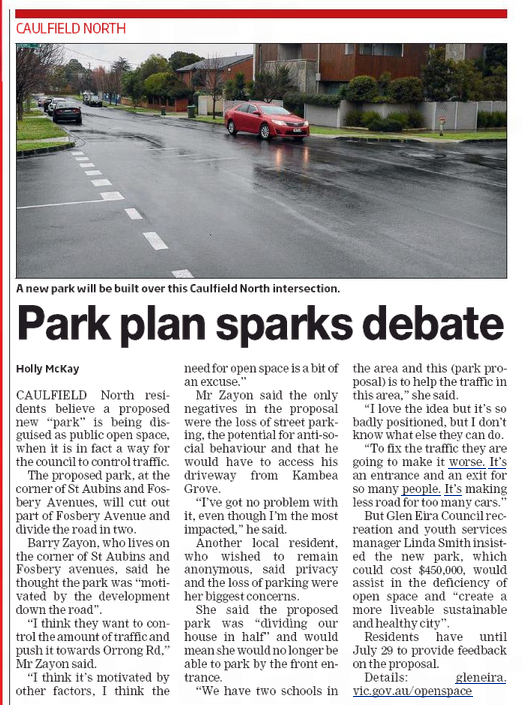
  • 15-19 Vickery Street, Bentleigh – 4 storey, 47 units
  • 11 – 13 Bent Street BENTLEIGH – 4 storey, 34 units
  • 37-39 NICHOLSON STREET BENTLEIGH – part 3 and 4 storey, 10 units
  • 670-672 CENTRE ROAD & 51 BROWNS ROAD BENTLEIGH EAST – 3 & 5 storey, 67 units
  • 23 Bent Street BENTLEIGH – 4 storey, 34 units
  • 817-819 Centre Road BENTLEIGH EAST – 3 storey, 26 units
  • 27 and 29 Jasper Road BENTLEIGH – 3 storey, 25 units
  • 64-66 Bent Street MCKINNON – part 3 and part 4 storey, 31 units
  • 14-18 Bent Street BENTLEIGH – 4 storeys, 55 units
  • 29-33 Loranne Street BENTLEIGH – 4 storeys, 42 units
  • 22-26 Bent Street BENTLEIGH – 4 storeys, 41 units
  • 24-26 Mavho Street BENTLEIGH – 4 storey, 28 units
  • The best is the sudden epiphany that the zones should have been reviewed. Perhaps Magee has not read the Planning Scheme Report since it states on page 108 – Glen Eira has completed its review of the new residential zones. Really? When? Why isn’t this ‘review’ public? What were the conclusions?  We also wonder what Magee means when he states that he has thought about this for a ‘long time’. Does this mean a week, a month, a year? If so, then residents need to be reminded of his comments which follow. The dates are from our postings. Incredible that as recently as February Magee could say that ‘we have a very, very good planning scheme’. Clearly a man who is consistent in his inconsistency!

‘I think the outcome for Glen Eira is superb’ (13/8/2013)

Said that 97% of the municipality has got height limits and 3% commercial with no height limits. Putting height limits on commercial areas has to be done through an overlay, and then community consultation, ‘permission from the minister’, and ‘through a long and detailed process’. ‘If council decides at some point in the future’ to do this, then he would ‘welcome that’ but to do ‘that we would need legal opinion, planning opinion’ and the Minister’s approval. There are some other things that might be done with the commercial zones but he is ‘very, very happy that’ the zones ‘cover 97% of our municipality’. This ‘in conjunction with our planning scheme’ is what ‘makes it work’. (25/11/2015)

‘We can sit up here and refuse it because we don’t like it’ but that would be ‘stupid’ since they know that it ‘already complies’ with ResCode and the planning scheme which was ‘put together with great community consultation with our residents’ who together with ‘council decided what can be built in what streets’ (30/6/2016)

‘I believe we have a very, very good planning scheme’. Last year ‘VCAT approved 582 apartments’ that had been refused by council and that was because ‘it wasn’t consistent with our planning scheme’. ‘Our planning scheme is what our residents said they wanted’. Council ‘went to the community’ and asked ‘Do you approve?’ and residents said ‘yes’. The minister then approved but VCAT ‘only have to consider it’. So when council consider buildings of 9 or 2 storeys ‘we look at residential building codes’, and the planning scheme. Councillors ‘sometimes’ give a permit to ‘buildings we don’t like’ mainly because ‘there are no grounds for refusal’. ‘It is wrong to say we want this and then to vote for something different’. Council and community has ‘asked’ for this planning scheme and that is ‘what is so disappointing about VCAT’ (4/2/2016)

Claimed that if council wanted VCAT to do anything then ‘it would have to be in the form of an overlay’. Overlays need a panel assessment and they could end up saying that ‘Carnegie is quite suitable for 13 storeys’ and Bentleigh ‘quite suitable for 6’. Council would then ‘have to argue against that’, then the Minister would ‘have information’ saying the opposite. S0 ‘there is a risk in asking for something’ that ‘you don’t get what you want’.(25/11/2015)

MAGEE: only the Minister ‘can do anything’ about the zones. When in opposition, Labor was ‘very clear’ that they were going ‘to review zones’ but haven’t done ‘anything about it so far’. He ‘believes’ that ‘we’ve got a very good system’ . In 2009/10 there was a ‘public review’ of the planning scheme and three things emerged that residents wanted – height limits, buffer zones, and ‘less discretion at VCAT’. ‘That’s exactly what the zones are doing’. Regardless of council ‘advocating for this change or that change’ or whether ‘we want a review the minister at any time can review’. Said that MPs are asking the minister to review zones in their electorates. Said that council was’ criticised at one point for not consulting’ but he thought ‘we very much did’ and now to ‘do a review of our consulting’ they would be ‘accused of doing the very same thing’. Glen Eira’s ‘system puts development’ where he thinks ‘it should be’ – in activity centres and along transport routes. Said that there are 3 Residential Growth Zones and the rest of the residential zones are in ‘shopping strips’. Thought that Glen Eira ‘is very, very lucky to have what it has’. If the minister ‘wants to tinker with that and reduce that’ then no council would have room for residential growth zones. If councils all got what they wanted it would all be neighbourhood residential zones. This would be ‘totally inappropriate and disrespectful’ to the 1000 people a year who come to live in Glen Eira. They have to be ‘accommodated somehow’ and currently council has got a ‘system that I certainly won’t be voting to change’ until the minister tells them ‘what that change will look like’. Was worried that if council ‘opened this up’ that the growth zones would increase and ‘neighbourhood zones would decrease’. (30/4/2015)

Apart from commercial zones, there is now a ‘sense of security’ for developers because they know what they can do and get a loan easier. Developers can therefore plan better. Said that the 4 storey buildings around tram lines is only 2.2% ‘of our city’ and ‘you might actually struggle to find a block big enough’ to build 4 storeys because of ‘setbacks’ on top floor. So a lot of these could ‘end up being 3 storeys’. Said it was a ‘really good outcome for the residents of Glen Eira’…..Congratulated officers on ‘getting this through’ and didn’t think it ‘was a surprise because that’s the sort of work we do here’…’we are very good at what we do’. In the future council can say ‘no, it’s wrong’ and ‘go away’ to developers because they haven’t got it right. Also have to thank the state government in ‘being proactive and helping us get this in place’. ‘I think the outcome for Glen Eira is superb’30/12/2014)

CONCLUSION

Not much needs to be said. We will merely ask this simple question – can anything that comes out of these councillors’ mouths be believed? Think of this when you vote!

As expected, the long awaited Planning Scheme Review, will NOT BE REVIEWING THE RESIDENTIAL ZONES as demanded by so many residents! Nor does the proposed work plan fill us with confidence that the municipality overall will greatly benefit from what is mooted – especially when suggested time frames go out to 4 years down the track. In this first of our posts we simply summarise sections of the suggested work plan and the  stated time for completion.

Structure Plans – Complete first 3 within 4 years. Ongoing, continue with structure plans each taking 1-2 years to complete. (Comment – given that there are 10 Neighbourhood centres – that is a time frame of between 10-20 years!)

Neighbourhood Character Policy – 2 to 3 years.

Heritage Internal Review – 3 to 12 months

Heritage Major Review – 2 to 3 years

Municipal Strategic Statement – 1 to 2 years

Local Planning Policy Review – 2 to 3 years

Development contributions levy – 2 years

Parking Provisions – 3 to 4 years

Open Space – 2 to 3 years

Sustainability Policy – 2 to 3 years

Water Sensitive Urban Design – 2 to 3 years

Transition between zones – 2 to 3 years

Special Building Overlay – 2 to 3 years

Tree Protection Policy – 2-3 years

COMMENT

We acknowledge that due to council’s failure to act on planning issues for the past decade, there is now a huge backlog of work that is required.  Having said that, residents should not be prepared to sit back and wait for another 2 to 3 years for changes to eventuate. The Minister’s directive to start work came in December 2015. Exactly what has council done in the past 8 months? How much money has been set aside in the budget to hire consultants to undertake the necessary work? How much of the upcoming work will remain ‘internal’ and secret – such as this statement from page 106 – Glen Eira has completed its review of the new residential zones. Though some community feedback is calling for Council to review the residential zone boundaries, particularly at ‘transition areas’ where two different residential zones meet, it is prudent to wait for the State Government to release its findings before any decision is made about reviewing our own locations.

And if council is so overwhelmed with the task ahead, then there is always the alternative of pinching what other councils have already successfully introduced into their planning schemes. Tree protection is the perfect example. Why this should take 2 to 3 years is laughable and says much about the underlying intentions of this council and its inept planners and councillors.

The minutes of the July 19th council meeting deserve close attention. We have focused on the Public Questions fiasco as well as Requests for a Report

Public Questions

“In light of ratepayers’ concerns regarding Skyrail and lack of transparency to date ,and Council’s unanimous motion seeking information from the State Government,how can Council justify charging exhorbitant fees in relation to FOI’d information?”

The Mayor read Council’s response. He said:

The Freedom of Information Act 1982 (Vic) provides the public with a right to access documents in the possession of agencies such as Council, subject to the exemptions in Part IV of the Act and subject to the payment of charges which are required to be paid by the applicant before access is granted in accordance with the Freedom of Information (Access Charges) Regulations 2014 (‘Regulations’). When processing requests under the Act, Council is bound by the requirements set out in the Act. Regulation 6 provides that an applicant who has made a request in accordance with section 17 of the Act is liable to pay charges set out in or calculated in accordance with the Schedule to the Regulations.

The Schedule to the Regulations sets out ten items together with the respective charges which agencies are required to charge applicants for particular services as part of processing their requests. These include the reasonable costs incurred by the agency in providing copies of documents. This is calculated by multiplying the relevant officer’s hourly salary by the hours spent in producing the relevant documents.

Council receives many requests under the Act every year and has limited resources available to process these requests. Requests made under the Act can be broad and require many hours of officers’ time to process. This can put a substantial burden on Council’s resources and cost ratepayers thousands of dollars. It also impacts on the provision of other services which Council provides to the community. It is therefore Council’s responsibility to accurately calculate and impose the charges payable under the Regulations for requests made under the Act to ensure that ratepayers are not disadvantaged by the processing of such requests, some of which can be significant in terms of officers’ time.

In most cases, charges calculated by Council under the Regulations are lower than the true cost incurred by Council in processing requests under the Act.”

COMMENT

There is much to quibble with in the above. We have uploaded the ‘regulations’ (here) so that readers may see for themselves what they state and the charges they include. For starters:

We do love the following questions and the ‘responses’ –

“Given council have spent in excess of $40k isn’t it time for the likes of councillor Hyams and Magee to stop with this childish behaviour towards Councillor Lobo and get on with the job of running the council not on public attacks within the council. I also believe we the rate payers are entitled to see what the QC thought in her report to council- this is public property not confidential; we paid (the rate payers) so we are entitled to be part of the evaluation process. A closed door mentality smacks of a boys club which is far from good corporate governance. The state government needs to watch this council closely.”

The Mayor read Council’s response. He said:

The Transport Planning department undertook observations of the parking demands prior to the restrictions being introduced in Phillip Street, Bentleigh. At that time, high,long term parking demands where being experienced along both sides of the street from Patterson Road to approximately No. 16 Philip Street. After the restrictions were introduced, the long term parking demands on the western side (i.e. the restricted side) of the street reduced considerably. The Metro Train Network Map (available on the PTV website) confirms that Patterson Station is located within Zone 2, as previously stated. However, since January 2015 commuters travelling across Zone 1 and 2 are only charged a Zone 1 fare (rather than both a Zone 1 fare and Zone 2 fare).

It is suggested by Mr Searle that the 2-hour parking at the off-street car park be converted to all day parking. It is considered that there currently exists an appropriate balance between the various car parking demands in the area. Converting short term, shopping centre customer parking to long term, commuter parking within the off-street car park could have a negative impact on the ability for shopping centre customers to find convenient car parking.

Council Policy Exclusion of Specific Developments from the Residential Parking Permit Scheme was adopted on 26 May 2013. After this date, new developments in local shopping centres have been excluded from the residential parking permit scheme. The list of properties excluded from obtaining residential parking permits within the municipality is available on Council’s website.

Council has received 17 enquires from residents of the Caulfield streets where parking changes were recently made. Residents of these streets have been advised that the new conditions will be reviewed in February 2017. However, ongoing feedback from residents will be sought to inform the review. Council has also this evening received a petition signed by 63 Caulfield residents. Finally, under Item 9.5 this evening Council resolved to review our Parking Restrictions Policy and review parking in Growth Zones, General Residential Zones and Neighbourhood Residential Zones.

++++++++++++

“Now the QC’s investigation is over and the report is in on councillors behaviour when will this be made available to the public and if not why not?”

The Mayor read Council’s response. He said:

Council will consider the report under Item 12.1 Confidential Business this evening. At that time Council will resolve what, if any, further action will be taken, and whether the report will be released publicly.”

+++++++++++

“Council will consider the report under Item 12.1 Confidential Business this evening. At that time Council will resolve what, if any, further action will be taken, and whether the report will be released publicly.”

The Mayor read Council’s response. He said:

“The only transcript of the meeting is the official minute which you will be able to access at the following link : http://www.gleneira.vic.gov.au/Council/Meetings-and-agendas/Council-meetingminutes?dlv_OC%20CL%20Public%20Meetings=(pageindex=2)

+++++++++++++++++++

The best ‘response’ however is –

Given council have spent in excess of $40k isn’t it time for the likes of councillor Hyams and Magee to stop with this childish behaviour towards Councillor Lobo and get on with the job of running the council not on public attacks within the council. I also believe we the rate payers are entitled to see what the QC thought in her report to council- this is public property not confidential; we paid (the rate payers) so we are entitled to be part of the evaluation process. A closed door mentality smacks of a boys club which is far from good corporate governance. The state government needs to watch this council closely.”

The Mayor read Council’s response. He said:

“Council welcomes your comments, however as they are not a Question, they do not satisfy the provisions under point 232 (Public Questions) of the Glen Eira City Council Local Law. If you would like to rephrase your comments as a Question and resubmit them we would be happy to consider them at a future meeting of the Council and respond accordingly.”

Request(s) for a Report

Crs Hyams/Magee

That Officers prepare a report into the potential for Council to collaborate with schools in Glen Eira to utilise their open space and grounds for use by sporting clubs and the wider community.

The MOTION was put and CARRIED unanimously.

This request for a report sounds very similar to another request dating back to 2008. The eventual Newton report, tabled months later, recommended the ‘revolutionary’ tactic of writing a letter to all schools and the Education Department. Of course, nothing positive eventuated from this rather lame attempt. Newton’s report was more of the same – schools are not our responsibility but the Government’s, etc. Thus, instead of offering schools real incentives (such as payment), the idea lapsed. And so typical of this council – no corporate memory, no real follow up, and no results over 8 years. Politically though, it sounds mighty fine to regurgitate something that was first mooted 8 years ago and then sank into oblivion.

Here is what the record states from 2008 –

Crs Esakoff/Whiteside

That a report be prepared into any opportunities that may exist for Council in the provision of additional/improved areas of open space that could be used for both passive and active recreation within Glen Eira’s existing school network.

The MOTION was put and CARRIED unanimously. (minutes of 26th February 2008)

Report by Newton tabled 20th May 2008. Council resolution read –Crs Esakoff/Spaulding

That Council write to all primary and secondary schools in Glen Eira along the lines of Attachment A and send a copy to the Victoria Department of Education

The MOTION was put and CARRIED unanimously

Of far more significance is the following request –

Crs Delahunty/Magee

That a report be prepared showing the expenses and expected revenue of the Wellness Centre at GESAC and that the report also show options for a social venture element and potential community or business partnerships that can be explored to deliver a social outcome

The MOTION was put and CARRIED unanimously.

Readers will remember that this issue was part of the budget ‘debate’ and was ultimately carried in the face of strong opposition from Delahunty, Sounness and Lobo. We make no comment on the Wellness Centre per se. What concerns us is the politics involved and the apparent lack of due diligence when councillors vote for something and the abysmal lack of information that is presented to both councillors and the public.

When tens or hundreds of thousands of dollars are earmarked for what some may see as ‘dubious’ ventures, then surely the rationale (including facts, figures, projections) should be automatically provided and disseminated. The reasoning behind the expenditure of public money should never be an ‘afterthought’ seeking political vindication or a cheap point scoring exercise.

High-rises plans for suburban stations to help fund level crossing removals
Adam Carey

The state government plans to build a residential tower up to 13 storeys high above the Frankston railway line in Melbourne’s south-east to help pay for its level crossing removals, in a strategy it wants to replicate across Melbourne.

The apartment building with street-level retail would be built on North Road above Ormond station, and in a first for Melbourne’s mostly low-rise suburbs, will be built directly over the railway tracks. It would be significantly taller than other buildings in Ormond.

The deck on the which the building would stand has just been built during the 37-day shutdown of the Frankston line between Caulfield and Moorabbin to remove three level crossings.

The line is due to reopen in a much transformed state on Monday.
Labor flagged in Opposition that it would develop land as part of some level crossing removals to help pay for other transport upgrades, including extra station car parking and yet more level crossing removals. Ormond marks the first example by the Andrews government of this “value capture” approach.

At up to 13 storeys high, the development would be much taller than any other building in that part of Melbourne, which is low-rise in character.

The building, which the government said would also include ground level shops and restaurants, would have to pass the usual planning hurdles before being approved.

Just south of Ormond, Bentleigh and McKinnon stations are also being rebuilt as their level crossings are removed, and land has also been set aside there for future development.

The government said developments at those two stations would be smaller in scale, in keeping with the village atmosphere.

Luke Donnellan, the acting public transport minister, said the Ormond station site on North Road was well suited to larger-scale residential development, given North Road was a busy six-lane arterial.

“This location is ideally suited to new homes and businesses – in the heart of a vibrant community, directly connected to transport, shops and opportunities,” Mr Donnellan said.

The government estimates the development will create 250 construction jobs and 300 ongoing local jobs at businesses that would occupy the new building.

The government has plans to remove 50 level crossings by 2022, and these three in Ormond, McKinnon and Bentleigh are among the first.

There are also plans to build a new tower at Gardiner station in Glen Iris, where the Burke Road level crossing was recently removed, the government said.

Other potential development sites have also been earmarked as part of the sky rail project, the removal of nine crossings on the Dandenong rail corridor.

Daniel Bowen, spokesman for the Public Transport Users Association, said there were good arguments for developing around railway stations, but predicted many locals would be shocked by the proposed height of the building Ormond station.

“Perhaps it will be a landmark but it would want to be very beautifully designed to have that status,” Mr Bowen said.

David Davis, the Opposition’s planning spokesman, said the proposed height of the development was excessive for Ormond.

“This is another treacherous step by [premier] Daniel Andrews,” he said. “The community will be shocked to see 13-storey towers built when they expected a more human scale.”

VicTrack, the government corporation that owns the state’s railway land, also has a number of development projects under way, including one over the railway tracks at Windsor station on the Sandringham line.

Apartment and retail developments at Hampton and Jewell stations are also under way.

Source: http://www.theage.com.au/victoria/highrises-to-soar-over-suburban-stations-to-help-fund-level-crossing-removals-20160725-gqd3gi.html

A petition was tabled with 63 signatures on ‘parking in Caulfield’. The petitioners stated that they didn’t ‘want 2 hour parking on one side of the street’ only and that council ‘reverse’ this decision because it ‘was done without hearing first’ what residents wanted. They asked council to introduce 2 hour parking on both sides of the street. They listed quite a few streets where this should happen.

Delahunty moved motion to ‘note and accept petition’ plus that officers ‘provide an update on preliminary and final findings’.  Lipshutz seconded.

DELAHUNTY:  acknowledged that there’s been an increase in parking issues and ‘that no area is safe’ from this. Thought it right that council is petitioned, but that it comes in the middle of a process ‘that we’re undertaking to gather some more thoughts’ and that the public will be ‘updated’ when the process is ‘done’.

LIPSHUTZ: claimed that because of the parking policy at Caulfield Hospital that what is happening is that ‘the nurses who are employed by the hospital are now parking in these streets’. But if there was 2 hour parking on both sides of the street ‘all that would happen is that the parking would shift’ to other local streets. Thus what ‘has to happen is a concerted approach and a total review of parking in the area’. That’s happening through ‘the review’.

TORRES: said that council is ‘reviewing broad areas’ and that ‘car parking can’t be looked at on a street by street basis’ and that restrictions in one street ‘has the potential to displace parking’ in another street’ so the issue has to be seen in a ‘broader area’.  Also said that ‘we are going to consult with the residents in this area after one month’ in order to ‘obtain preliminary feedback and findings on the effect of the changes’.  After the ‘prelimary findings’ council would ‘continue to receive feedback and engagement’ with residents and then they will have a ‘far more comprehensive review to report’ at the end of February.

LIPSHUTZ: he supports council in reviewing ‘overall parking’. ‘There is a problem, there’s no doubt there is a problem’ for people living on the south side of Glen Eira Road and people are now parking on the north side as well. Thus ‘there needs to be a concerted approach’ and that is ‘the right way to go’.

LOBO: said this is the second petition within 4 weeks – another one from Bentleigh. Agreed that cars might shift from street to street but residents pay their rates and council needs to start thinking about building ‘3 or 4 parking storeys’. Claimed that this ‘is a result of the developments taking place’ and that ‘infrastructure will not be enough if we are going at the rate we are going’. Wanted council to ‘get our wheels in motion’ to have ‘3 or 4 storey’ parking facilities in Bentleigh and Caulfield and ‘particularly 2 or 3 in Carnegie’.

DELAHUNTY: said that in the area of the petition there is the impact of ‘local employment’ and this is something they ‘want to encourage’. But ‘how do you do that in a hospital setting’ when you’ve also got shift workers. Claimed the ‘solution’ was to ‘listen to the residents’ and that the petition ‘forms part of the consultation’. Acknowledged that it is an ‘incredibly difficult’ issue.

MOTION PUT AND PASSED UNANIMOUSLY

COMMENTS

There is much here that is unacceptable in our view –

  1. Why weren’t residents consulted first before any action was implemented?
  2. On what statistical basis were these changes made? Why hasn’t the evidence been provided?
  3. Torres’ claim that council can’t look at parking ‘street by street’ is surely open to challenge. Moonee Valley Council seems quite capable of investigating its municipality street by street. Why can’t Glen Eira?

FYI – we urge all readers to consider the Moonee Valley approach in terms of direct community input, comprehensive community consultation, and real street by street evaluation. It is also worth taking a look at the links to the documents provided in this URL – http://mvcc.vic.gov.au/for-residents/parking-and-transport/current-transport-projects-and-studies/local-area-traffic-management-plans/buckley-park.aspx

For Residents

Buckley Park Local Area Traffic Management Study

We have been undertaking Local Area Traffic Management (LATM) studies in selected precincts within the municipality in order to manage vehicle movements, review parking restrictions and improve the residential environment.

In 2015/16, we are undertaking a LATM study of the Buckley Park precinct as part of this ongoing LATM program. The study area (pdf, 222KB) is bounded by Keilor Road, Lincoln Road, Buckley Street and Hoffmans Road in Essendon.

The study includes an extensive community consultation process to involve the local community in identifying traffic and parking issues and provide opportunities for community feedback on the developed traffic and parking proposals.

Working group

We have formed a working group comprising 10 community volunteers, Ward Councillors, Council officers and traffic engineering consultants.

The role of community volunteers is to provide local information, act as a contact for the local community and to provide feedback in the development of traffic and parking management plans for the area.

View the Terms of Reference for the working group.

Initial community questionnaire – traffic and parking issues

A questionnaire on traffic and parking issues in your local area was posted to properties in the study area in August 2015.

The closing date for questionnaire responses was Monday, 14 September 2015. Thank you to everyone who responded. The information you provided has helped to identify problem areas and assist us to develop draft traffic and parking management plans for the area.

Draft traffic management plan

A draft Traffic Management Plan (pdf, 1.1MB) setting out recommended solutions to traffic issues has been developed and circulated with a questionnaire to all properties and property owners in the study area for community comment.

The draft plan aims to address the key issues identified by the community in the initial questionnaire on traffic issues distributed to local properties in August 2015, as well as feedback from the Working Group.
The proposal has been considered on an area wide basis to minimise any adverse impacts on adjacent streets.

The objectives of the draft plan are to:

  • Reduce the incidence and potential for vehicle and pedestrian crashes in the local area.
  • Improve the safety of local streets by reducing traffic speeds.
  • Discourage through traffic from using the local area.
  • Develop proposals that address traffic concerns raised by the community, while maintaining adequate levels of accessibility for local residents, local businesses and emergency services.
  • Maximise the safety benefits with the available funding (with priority given to reported crash locations and those streets with the greatest level of community concern).

The closing date for questionnaire responses was Friday, 1 April 2016. Thanks to everyone who responded.

The community response to the draft plan is being reviewed by the Working Group, prior to presenting a recommended Traffic Management Plan in a report to Council.

Draft parking management plan

As part of the LATM study, the existing parking conditions within the local area have been reviewed. A draft Parking Management Plan (pdf, 340KB) setting out proposed changes to the parking arrangements in the Dean Precinct local area has now been developed.

This component of the project has involved the collection of an extensive set of parking occupancy data in addition to community and Working Group feedback. 

Using the parking occupancy data, the streets where parking changes are warranted have been determined based on our Parking Demand Management Framework.

Our Kerbside Road Space User Hierarchy was then used to determine appropriate parking restrictions in each street.

Below are streets which have proposed changes to existing parking arrangements along with the general location of the changes:

Street    Location
 Collins Street  Queen Street to Market Street
 Cooper Street  Spencer Street to Buckley Street
 Gilbertson Street  Keilor Road and Market Street
 King Street  Collins Street and Lincoln Road
 Lincoln Road  Queen Street and Market Street
 Queen Street  Lincoln Road to end
 Spencer Street  Collins Street to Lincoln Road
 William Street  Collins Street to Lincoln Road
 Keilor Road  McCracken and Collins Street

Residents and property owners in the streets that are directly affected by the proposed parking arrangements have been sent a questionnaire survey to seek their views on the proposals. Alternatively, community members can also provide their views on the proposals via an online questionnaire (external link).

The closing date for responses was Friday, 1 April 2016.

The community response to the draft plan is being reviewed by the Working Group, prior to presenting a recommended Parking Management Plan in a report to Council.

++++++++++++++++++++++++++++++++

We make no comment on the outcome for Moonee Valley – ie how ‘good, bad, poor, inadequate’, etc. their plans are. What we wish to highlight is the PROCESS. How one council can, if there is the will, to involve its community before decision making, rather than after the fact which is what Glen Eira consistently does. That means that ‘consultation’ is nothing more than a token exercise when the decision has already been made. Nor are those councillors who consistently endorse such a top-down approach doing anything to engender real confidence that resident views will be listened to and acted upon. Ultimately, drastic and dramatic change is required!


park

If these residents are correct and this proposal is all about traffic management, then it is a pretty expensive way to resolve the issue. Of course, no one knows exactly how much this ‘park’ will cost! Nor are we privy to its size or how much of this area will be covered by concrete. No traffic analysis is provided (and we doubt it’s even been done!) in order to gauge the potential impact of closing off streets.

Other issues also need to be considered –

Pocket parks are, according to the research literature designed to alleviate the lack of open space in a HIGH DENSITY area. This proposal is smack in the middle of a Neighbourhood Residential Zone – ie LOW DENSITY. When other areas such as Carnegie are literally crying out for more and more open space and have less than North Caulfield, why doesn’t this area get priority?

According to the Open Space Strategy (OSS), Carnegie has 21.07 hectares of public open space. Of the ‘recommendations’ contained in the OSS for ‘additional open space’ all of the 5 recommendations carry the priority rating of ‘Very High’. In contrast, Caulfield North has 26.28 hectares of public open space; of the 6 recommendations made for ‘additional open space’ only one carries the ‘very high’ classification and this is for ‘gap area C1’. The proposal for Fosbery/St Aubins is not C1! Another 4 recommendations are rated as ‘high’ priority and one other as ‘medium’.

Thus, on every single criterion, Council’s proposal fails to meet the recommendations of its own OSS, plus residents are being asked to comment without being provided with the necessary full information. Residents in Carnegie have every right to ask if they are viewed as second class citizens when it comes to open space and the necessary funding.

csThe most significant aspect of this survey which the Leader article does not focus on, is the discrepancy between resident evaluation of the importance of a service and the perceived ‘results’. Differentials of well over 20 signal a new low point in Glen Eira. For example: residents believe that ‘consultation’ is vital, giving it a ‘rating’ of 75 for ‘importance’. Their judgement on performance is 51! What should also be highlighted is that the differential between importance and performance has been growing steadily over the past few years – yet council has failed to address this decline. No amount of spin can disguise this fact!

Here is one page from the survey –

Pages from Community-Satisfaction-Survey-2016

PS – BY WAY OF COMPARISON, HERE ARE THE RESULTS FROM THE 2014 SURVEY. PLEASE NOTE THE INCREASE IN THE DIFFERENTIALS BETWEEN IMPORTANCE AND PERFORMANCE

Pages from Community_Satisfaction_Survey_Report_2014

PPS – Not all councils have thus far published the results of their surveys. However, we’ve taken the opportunity to highlight some of these results as a further comparison with Glen Eira. For starters, Stonnington and Greater Dandenong DID NOT HAVE ANY SERVICES WITH A GREATER DIFFERENTIAL OF 10 POINTS.  The screen dumps (below) from Whitehorse and Boroondara reveal that their residents’ angst is nowhere near those from Glen Eira’s population and the number of services with a discrepancy of 10 or more points is also well below the number to be found in Glen Eira.

whitehorse

Untitled

No denying that more open space is desperately needed in Glen Eira. That has been the perennial call from residents since time immemorial. Council’s  ‘solution’ is to turn streets into so called ‘parks’.

Currently there is another ‘consultation’ ongoing in regards to closing off the corner of Fosbery and St Aubins Avenue in North Caulfield. Replete with pretty pictures, the consultation provides no information on:

  • The impact on traffic
  • The size of this new ‘park’
  • The cost of creating this ‘park’
  • The ‘value’ of such endeavours? – ie what assessment has been made of the Eskdale Road and Riddell Parade ventures? How well are they used? Does this represent ‘value for money’?

Nor have residents been provided with any justification for the selection of these streets – particularly when the Eskdale Road closure is a stone’s throw from Caulfield Park, and the proposed Fosbery Street one is within 400 metres of Greenmeadows park.  Why were these streets chosen and not ten others?

Confounding the choice even further, we highlight the following tender which was approved in August 2014 –

That Council appoints Fercon Pty Ltd, ACN 116 527 363 as the contractor under Tender number 2014.046 St Aubins Avenue and Fosbery Avenue Reconstruction for an amount of $908,176.00 exclusive of GST in accordance with the schedule of rates submitted

This clearly leads to a series of important questions:

  • Have ratepayers spent a million dollars on ‘reconstruction’ only to have this now ripped up with new ‘reconstruction’ for the ‘park’?
  • If so, where is corporate memory? Does the right hand ever know what the left hand is doing?

Conclusions?  If council is prepared to spend millions on landscape design, consultation, and the short sighted option of closing off streets instead of real investment in new, multi-purpose open space, then they need to be upfront with residents and provide solid reasons based on facts, evidence, rationale, and evaluation as to the efficacy of their decisions. Presenting residents with a series of cute little pictures and calling this ‘consultation’ is insulting. Decision making must always be based on the full facts. This is not happening.

Three planning applications for Tuesday night’s council meeting deserve some close attention and questions asked about:

  1. The competency/objectivity of the planning department
  2. What outside influences are at play here?

We are not arguing in favour of development here. We are simply questioning the basis of this council’s decision making.

One application involves Bentleigh, and the other Carnegie. Both are zoned RGZ, and both are within council’s lines drawn on a map that designate them both as being within the Urban Village structure. Yet, remarkably, the one in Bentleigh for 30 odd units receives the nod of approval and the one in Carnegie for ‘only’ 13 units is refused. Why? – when both are basically ‘compliant’ with the planning scheme? Secondly if the one in Bentleigh can be ‘fixed’ via the imposition of conditions, then why not the one in Carnegie?

Even more disturbing is the absolute rubbish that we find in the Rocky Camera reports – inaccuracies, and blatant bias as evidenced in the following. We’ve drawn up a table so that readers can compare like for like.

applications

The Tranmere Avenue application also makes reference to Skyrail and the land’s proximity to the proposed rail line. The developer has submitted a noise impact statement for trains at ground level only. Given that no one knows much about Skyrail and its impacts, it is interesting to note that for Montgomery House application council granted a permit with the notation that should Heritage Victoria not rule in favour of retention, then a new application can be submitted. No such leeway was provided to Tranmere.

Application for 2 double storey in Barry Street, Bentleigh

Please note:

  • The site is zoned Neighbourhood residential Zone – ie suitable for 2 dwellings
  • No objections
  • Area of approximately 650 square metres – well and truly able to ‘cater’ for 2 double storeys

The officer’s report states:

  • An acceptable level of articulation has been provided for the development. The first floor is recessed behind the ground floor walls, with minor staggering of facades providing further articulation. Single garages are proposed ensuring that garages are not a dominant feature of the development.
  • The dwellings have both been provided with ground floor, east-facing private open space areas of 58m2 and 87m2 respectively, in accordance with the requirements of the zone and Rescode.
  • There are adequate landscaping opportunities at the front and rear of the site. Councils Landscape Officer has recommended that two canopy trees be planted in the front and rear yards of each dwelling (4 trees in total). Site coverage is less than 50%, which complies with Rescode requirements.
  • All proposed setbacks are in compliance with the State Government guidelines

 COMMENT

Thus we get a page and a half report where practically every aspect of the planning scheme is met, plus NO OBJECTIONS TO THE APPLICATION. Yet, it still is put on the agenda for a council resolution. Why? When countless other applications are decided at officer level, why is this one granted the privilege of a council resolution? What factors are at play here? Why is council’s time being wasted on such an application when the agenda is already overpacked (a mere 721 pages for Tuesday night). Is this a case of someone knowing someone else? Or knowing what might eventuate a year or two down the track? Who is responsible for getting this onto the agenda and what are the real motives?

The latest Development Plan for the Mixed Use Precinct of the Caulfield Village reveals once again the failure of this council to keep its residents informed as to what is really going on. Worse still, the proposed plans are another example of MRC profit making and to hell with the local community.

Council Secrecy

The plans reveal the following (and we quote) –

On 27 May 2014 Glen Eira City Council (GECC) approved the initial Development Plan for Caulfield Village (DP 16060/2013) relating to that part of the Residential Precinct west of Bond Street. That Development Plan approval was subsequently amended on a number of occasions, most recently on 05 May 2015  (page 6 –Town Planning Assessment Report)

Condition 24 of Development Plan approval DP 16060/2013 required that the proposed design of the Normanby Road / Boulevard / PHE / Sir John Monash Drive intersection be resolved and approved by SJB Planning Council before further work on the future stages of Caulfield Village can advance. Following extensive engagement with State and local government stakeholders, an updated Integrated Transport Plan was submitted to Council for endorsement on 01 October 2015. (Page 13/14)

Thus, the MRC keeps putting in amended plans and residents know nothing about the amendments and what concessions have undoubtedly been granted to the MRC and by whom! There has not been any formal council resolution on the 5th May 2015, nor any notice that amendments were sought. Why not? And who made the decisions and under whose authority? And as we stated in our previous post, who made the current decision to ‘refuse’ the new Development Plan and what were the grounds of refusal? Why aren’t residents informed as to what is going on until after the fact?

The Development Plan

There is much that could be said about this current proposal. We will only highlight the most obvious things –

  • Another 397 apartments proposed in 4 buildings
  • Building A – 9 storeys of 56 one bedroom and 56 two bedroom
  • Building B – 9 storeys of 44 one bedroom, 56 two bedroom and 9 three bedrooms
  • Building C – 5 storeys of 36 one bedroom and 12 two bedroom
  • Building D – 7 storeys of 92 one bedroom and 36 two bedroom

Thus the percentage of family oriented three bedroom apartments is the wonderful number of 2.26% – whereas the documents claim 5%!

The proposed configurations of these apartments are also nothing to write home about. For example:

No of apartments under 50 square metres – 51

No of units between 50 and 60 square metres – 60

No of balconies under 8 square metres – 71

We remind readers that council caved in on the requirement for 8 square metres of balcony on a previous amendment. Also the State Government’s Better Apartments is looking at legislating for a minimum size and 50 square metres is one suggestion.

Traffic Management & Parking

  • Thanks to the incompetence of the Incorporated Plan, there is NO VISITOR CAR PARKING
  • 397 units plus retail only warrants 441 spots
  • The ‘statistics’ used date from 2010 and ‘updated’ in 2013! No mention of course of impacts on Eskdale Road, Newington, and other local streets all round the precinct!

Affordable Housing

We are so dumbfounded by this proposal that we cite it in full. Please remember that some councillors wrung their hands in dismay when there was no provision for ‘affordable housing’ in Precinct One. The argument put forward by the Lipshutzs and Hyams and Pillings of this world, was that the other precincts would fulfill this requirement. Well here is the ‘master plan’ for affordable housing, courtesy of the MRC. We are sure that readers will get a good laugh out of the following:

Aspirations for the provision of affordable housing within the Caulfield Village development are expressed in the Incorporated Plan. In the current absence of a Federal or State Government scheme to support the development of affordable rental housing, BPG has given detailed consideration to how it might self implement an opportunity for affordable housing within its development that is suitable to Caulfield Village and the broader Caulfield context.

The Caulfield Village & Affordable Housing Report at Appendix Q explores a variety of models that might be adopted to facilitate affordable housing opportunities within the development. It identifies the “Pathway to Ownership” model as the most appropriate having regard to the particular circumstances of the proposal and its context. Broadly, the model would offer assistance to low-to-moderate income renter households to purchase an affordable home in the Caulfield Village development by providing people in affordable or private rental with a savings record an opportunity for assistance to meet the necessary start up funds to facilitate ownership. Deposit subsidies from BPG to eligible participants also form part of the assistance package. The scheme would be administered by a community housing provider. It is anticipated that eligible purchasers would currently be living in community housing or private rental accommodation, with limited opportunities to otherwise enter the housing market.

The added benefits of the scheme include the direct expertise of a community housing provider to assist appropriate and eligible candidates on the pathway to ownership, and the freeing up of low rental accommodation previously occupied by participants in the Pathway to Ownership scheme.

The preferred affordable housing model, which will be known as Caulfield Apartment Start Program (CASP) could potentially be applied to any of the proposed accommodation within the development, rather than limited to certain apartments or apartment types. Likewise there would be no limit to the number of apartments able to be purchased under the affordability scheme. The model applies a subsidy to eligible purchasers, rather than dwellings. It is uncertain, until the scheme is up and running, what the uptake of accommodation through the Pathway to Ownership model will look like, but BPG is committed to implementing the program for accommodation within the Mixed Use Precinct, and potentially future development stages

Our final word of caution

Whilst the variously dated Incorporated Plan (ie some of the documents refer to the Incorporated Plan as being 2011 and other documents cite 2014!) stated that the maximum preferred heights for Precinct 1 was 5 storeys, we now have 6 storeys looming over Station St. This is because of the neat little trick perpetrated by the MRC and permitted by council of using the formula of AHD. This refers to sea level heights. Thus if the land is sloping, then instead of the preferred height of say 5 storeys, the MRC can build 6 storeys. Council of course, and all their expert planners, did not pick this up – or if they did, did not care! Thus we warn residents that the mooted heights of these building are just that – mooted and nothing is set in concrete!

PS: stuck between the four building of 9/10 storeys, and 5/6 and 7/8 storeys, the MRC proposes to create a ‘pocket park’. The accompanying visuals are astounding: vast expanses of ‘open space’ that make the area look like a major park and not a ‘pocket park’. No real high rise to dominate the site; no overshadowing whatsoever, and nowhere in the landscape plan could we find any data which states the size and dimensions of this proposed ‘park’. What we do know at this stage is that 25 onsite trees will be removed and 14 street trees at least!

pp


« Previous PageNext Page »