 AND
AND
March 11, 2015
AND
March 10, 2015
 PS: – CHANNEL TEN NEWS – http://tenplay.com.au/news/melbourne/2015/3/10/bulldozer-battle
PPS: CHANNEL SEVEN NEWS – https://au.news.yahoo.com/vic/video/watch/26586585/pensioner-wins-home-fight/
March 6, 2015
We have been noticing a very definite trend occurring throughout Glen Eira. Developments with existing permits are reselling. Some gained permits years ago and the property has either been rented out, stood empty, or simply allowed to accrue in value. This of course implies that there has been extension upon extension granted by the planning department.
The screen dumps below illustrate the trend completely. On the 22nd August an application was submitted for a 3 storey apartment block in Bent St. Bentleigh. That is ONE DAY prior to the gazetting of the new zones and hence was assessed under the ‘transitional provisions’. Cometh the new zones a day later, four storeys is now allowable.
Please note carefully the associated blurb in the following:
March 4, 2015
On the 25th February 2015, both sides of politics passed this motion in parliament.
That in accordance with standing order 11.01, there be tabled in the Council, by 12 noon on Wednesday, 11 March 2015, a copy of the report prepared for the Minister for Planning by the Residential Zones Standing Advisory Committee concerning draft amendment C125 relating to the city of Bayside.
Amendment C125 relates in part to Bayside’s attempt to basically overturn the Residential Growth Zones in its municipality. We will refrain from commenting on the performance of this Standing Advisory Committee thus far and its previous recommendations concerning Kingston, Moreland, Moonee Valley and so on. What is of interest in the debate are the comments representing all sides of politics.
We also suggest that when reading the following, readers keep in mind what occurred in Glen Eira – that is: secrecy, no consultation, and deliberate obfuscation in response to various public questions.
MR DAVIS (Southern Metropolitan)…… This is about the shape of our suburbs. This about residential amenity. I put on record as a general principle my belief that there is great scope for transit-orientated developments with a focus on higher density in and around transport nodes, but it must be done in a way that brings the community with the proposals. It needs to have full community consultation, and councils and the community need to be working in harmony to see developments like that accepted and brought forward. They must be designed in a way that is sympathetic to the community.
This motion is a narrow one. It seeks to make public that report by the panel. I can indicate that the opposition will make some further decisions when we see that report, but it is clear that amendment C125 and the proposals around it need some significant further work. The panel report is a key document that should be in the public domain to inform public debate, and for that reason this motion is in the public interest.
Ms DUNN (Eastern Metropolitan)—In short, the Greens certainly support this motion. We support open and transparent government and of course we support the release of the planning panel report in relation to amendment C125 to the Bayside planning scheme. What is important in relation to this is what the community thinks about the nature and shape of their suburbs. It involves the character, amenity and built form of the area, and certainly planning scheme amendments provide ample opportunity for those matters to be picked up through design and development overlays and schedules attached to the planning scheme.
The planning panel report will provide an opportunity to see how those consultations went. It will be interesting to understand the length and breadth of the contributions and how many people had an opportunity to participate. The reality is that this is about the shape and nature of our suburbs and of Melbourne, so it is important that communities share that journey when we are talking about matters as important as planning scheme amendments and the difference between general residential zones and residential growth zones. Certainly the Greens support the release of this planning panel report, and we look forward to seeing what is contained within it.
Mr SOMYUREK (Minister for Small Business, Innovation and Trade)—The Residential Zones Standing Advisory Committee has prepared its report on amendment C125 to the Bayside planning scheme and has submitted it to the department for assessment. The Minister for Planning will shortly be briefed on the recommendations of the independent committee for his review. Once a decision has been made by the Minister for Planning the report will be released. It is in no-one’s interests to prolong the debate, and the Minister for Planning requires suitable time to assess the independent committee’s recommendations without interference. If the committee report is released prior to a decision being made, proponents and the community will continue to make submissions on the substantive matter and the panel report. This does not add to the quality or timeliness of the decision-making.
There is a clear and transparent process for consideration of these proposed amendments, and it is important that this process is honoured. While it is at the minister’s discretion as to whether to release the committee report, I can confirm that the minister will release the report once he has been briefed and a decision has been made.
This government is committed to clear and transparent decision-making that takes into account the views of the community. We were very concerned about the mismanagement of the process for the rollout of the new zones and will be undertaking a full review.
Motion agreed to.
PS: From this week’s Leader ‘Letter to the Editor’.
March 3, 2015
The MRC and/or its developers have submitted an ‘amendment’ to the approved Development Plan. We urge all residents to view the documentation at – http://www.gleneira.vic.gov.au/Council/Planning_and_building/Planning/Caulfield_Village/Amended_Development_Plan
The main points of this amendment, following a very brief perusal of the documents, are:
We also have to marvel at the sheer gall of the ‘summary’ (uploaded HERE) – in its continual use of euphemism and gobbledygook, as well as its insistence on the Incorporated Plan as the planning ‘bible’, rather than the Development Plan which surely is the equivalent of a set-in-concrete planning permit. We remind readers that council’s support for the Incorporated Plan included the argument that it was only a ‘conceptual’ document and that the Development Plan was the important one in terms of gaining planning approval.
We’ve dug up the Rocky Camera report on the Development Plan from December 2013 in which he stated:
This document gives certainty to the local community by precisely stipulating building envelopes; their heights, setbacks, and siting. It can be said that the Caulfield Village development is one of the most planned development sites in the municipality. The future development of this land has been “locked in” following a rigorous community consultation and amendment process, the community now has a high level of certainty in what to expect at Caulfield Village
Finally, here are some quotes from the proposed new amendment:
The amendment sought under this cover are a combination of necessary design refinements informed by these processes, as wellas realising an opportunity to optimise the efficiencies of the development within the general parameters of the approved Development Plan and prescriptive guidelines of the Incorporated Plan.
The majority of changes described in the Schedule are very minor cosmetic changes that will have no impact on neighbouring properties.
It is considered that the changed described above are so minor in nature as to be de minimis and entirely consistent with the approved development as endorsed.
Whilst it is acknowledged that most dwellings comprise one or two bedrooms, within each of the approved buildings there is a broad range of dwelling layouts, types and sizes provided ensuring that the development makes a meaningful contribution to dwelling diversity.
The increases to the building envelope at the fifth floor level are very minor and will servie to enhance the functionality of the apartment without compromising the usability of the balcony areas. The increases are so minor as to be negligible when viewed from Bond Street.
There’s much, much more that could be quoted. Interestingly, in a 7 page document the word ‘minor’ is repeated 17 times! As always, the ball is now in councillors’ court!
March 2, 2015
Apologies for another long post!
At last council meeting councillors voted to abandon Amendment C124 which proposed to rezone a disused industrial site in Clairmont Avenue to General Residential Zone 3 (ie three storey height limit). This was undoubtedly the ‘right’ decision, but it also raises innumerable questions regarding:
We will go through each of the above points in turn.
Due Diligence
Most of the arguments for rejecting the proposed amendment were known right from the start – ie traffic concerns, predominantly Neighbourhood Residential Zone area, lack of transport nearby or shopping strips. In the 6 months that it took to receive permission to advertise the amendment, receive submissions, go to a directions hearing and then a Panel Hearing, none of these factors CHANGED. So why did ratepayers have to fork out thousands and thousands of dollars for a panel, plus staff time, to propose something that was eventually overturned by councillors? Did councillors perform due diligence right from the start and investigate the area, and the proposed amendment thoroughly for themselves? If they did, then why didn’t they reject the proposed amendment much earlier in the process? Or was it that residents of Clairmont Avenue actually got together and started serious lobbying of councillors?
In the discussion for this item, (see below) several councillors made mention of the fact that they had received numerous calls from residents. We congratulate residents, but our argument remains constant. Councillor decisions should not be based on the number of complainants but on the facts of the matter. If all the arguments that appeared at the last minute and lead to the abandonment of the proposal were there right from the start, then the amendment should never have been entertained. It should have been rejected outright last July. It wasn’t, and so ratepayers find themselves funding another useless exercise in double-speak and bureaucratic bungling. Nor does this entire episode cover councillors in glory. For instance: why didn’t they listen to residents right from the beginning? Why did they merely blindly follow officer recommendations – not once, but twice, only to baulk at the final decision?
The Officer Report
Selective editing of important documents is not new to Glen Eira City Council. Unlike countless other councils, Panel Reports are rarely included (in full) in tabled minutes or agendas. Residents either have to physically go down to council to ‘inspect’ or wait until the Department places them up on their website. More worrying is that when decisions are made to adopt, reject, or amend, what is left out is often more telling than what is stated. There is much in this Planning Panel Report (uploaded in full HERE) that does not get a mention in the council minutes. Most of what is omitted is of course what council would like to keep out of the public domain. For example:
The Panel agrees that the application of the NRZ would be largely appropriate if it were not for the fact that that zone makes no proper allowance for development of redundant larger sites such as the subject site. (page 11) In other words, the current planning scheme is inadequate to deal with the two storey height limit imposed in NRZ for large sites.
And there’s more, including this explicit criticism of the ‘reformed’ zones –
While it might be possible for a multi‐unit development to be developed on the subject site by subdividing the land in advance of construction, in my view this would not be a practical approach to development of the site, especially if the development involved dwellings on more than one level. The provisions of the NRZ may well be have been designed to place stringent limits on the intensification of housing on prevailing standard sized house lots, but the absence of any provisions recognising the possible presence of larger sites within that zone with potential for redevelopment is a strange omission.
Accordingly, I agree with the Council that it is not reasonable in terms of making efficient use of the land for residential purposes to include the land in the NRZ. The GRZ3 is an appropriate choice – a zone specifically designed for in‐fill sites.
Conclusion? The Panel’s agreement to the rezoning of the land to GRZ3 is largely based on the fact that the current planning scheme has so many ‘omissions’, and is so inadequate to deal with this issue, that the only feasible solution is a GRZ3 zoning. The officer’s report naturally omitted this important paragraph and only included the final paragraph shown in the above quote.
What’s even more disconcerting is that the Panel has to recommend that Council to get off its backside and do something about traffic and parking issues in the street as well as ensuring that permits are adhered to.
The Panel noted the reasonably large amount on street parking occurring in the street at 4:15pm on the day of its inspection (more than 17 spaces were occupied) and that vehicles were being driven away around that time by persons apparently leaving work for the day. The Panel requested that Council particularly address this issue raised by submitters.
At the Hearing, Ms Pascoe advised that the Council’s engineers were aware of the parking and traffic issues in the street. She said that they were partly caused by the panel beating and motor repair businesses now operating on the site which have no planning permission. Enforcement proceedings have been initiated.
Again, this was not mentioned in the officer report! Nor was there any mention of the fact that the ‘accuracy’ of the applicant’s Traffic Report was seriously queried by Council’s Traffic Department. Yet, the amendment was still drafted and presented to councillors without spelling this out.
Finally, presented below is the ‘discussion’ on this item. We ask readers to pay careful attention to the various commendations of residents and keep in mind that ‘populist’ decisions do not equate with councillors performing due diligence and making sure they are fully acquainted with all the facts of the matter. Otherwise more and more money will be wasted on such enterprises whilst the real culprit, the planning scheme, remains untouched and unrevisited!
The Council ‘Discussion’
Hyams moved motion to abandon amendment and to notify applicant that council would be prepared to support an amendment to rezone to Neighbourhood Residential Zone. Seconded by Lobo.
HYAMS: said that there was ‘little doubt’ that the area should be rezoned for residential but the ‘question’ is whether this be NRZ or GRZ3. Said he would have liked to vote on the NRZ zoning now but ‘legal advice’ told him that they couldn’t do this without first abandoning the exhibited amendment and coming up with a new one. The choice is therefore to adopt ‘as proposed for GRZ3’ or to abandon. So ‘after consulting with residents’ he is prepared to ‘try and get a better result next time’ with a new amendment. He’s read the panel report, seen the site and talked with residents and thinks that GRZ is ‘inappropriate’ since it’s already a ‘narrow and busy street’ with a nearby school and an aged care facility that got approval for more beds up to 100+. There’s the questions then of whether the street ‘can handle’ all this traffic. GRZ zones are also ‘generally near shops and public transport’ and this doesn’t apply here. Once a GRZ zone is declared then it ‘limits our ability’ to control ‘what goes there’. Said it would be ‘ridiculous’ to limit ‘such a large block to 2 dwellings’ as applies in the NRZ but ‘that can be overcome through subdivision’. Thought there could be 8 blocks. Residents weren’t happy with the industrial zone because of ‘the noise that comes out of that’ but that they hope to get this right.
LOBO: said this is ‘most certainly not appropriate for our residents’ . Said that he and residents are ‘appalled that we are continuously giving in to the wishes of developers’. Said it is ‘shocking to see the opportunist’ wanting to ‘reap the benefit’ without ‘any concern for the residents’. Said that the spate of development has ‘drowned everyone including the best swimmers’. Residents told him last Sunday’ that they hadn’t got any letter from council inviting them to the panel hearing and the panel report then noted that no objector showed up. The aged care facility will see ‘another 101 residents’ and parking will be bad and bottlenecks for parents dropping kids off at school. ‘3 schools in the vicinity’. ‘The panel is out of touch with reality’ and that ‘they have no clue whatsoever compared to councillors’.
MAGEE interrupted and asked Lobo to ‘speak directly’ to the motion and to ‘leave the rhetoric and the stories out’.
LOBO: repeated the problems with the aged care facility and that the street is used as a thoroughfare through to Nepean Highway. Urged councillors to abandon amendment as this would ‘give a breather to the residents whom we are supposed to represent’.
MAGEE retorted that he thought that is what councillors do.
LIPSHUTZ: asked Torres about notice of the amendment. Torres responded that there was an ‘exhibition period’ and that residents ‘were informed of the amendment’. Also that it was the Planning Panel which notified submitters of their option to attend the hearings. Said that submitters did participate in the ‘directions hearing’ but that at the actual panel hearing ‘submitters chose not to attend’.
LIPSHUTZ: he ‘took umbrage’ at Lobo’s comments about council and developers. Said that ‘there is nothing wrong with profit’ and that the developer purchased this industrial site and now want to make a profit and that ‘this is a good thing’ because ‘that’s how we grow our society’. Besides, this developer hasn’t even put in a proposal yet so Lobo is ‘jumping the gun just a little’. At first he thought that there was ‘nothing wrong’ with the draft amendment. He then ‘went down the street’ and because it is a ‘narrow street’ and because of the nursing home a NRZ is the ‘preferred way to go’. ‘It’s not because of greed’ and councillors make decisions on what they ‘think is right’. They don’t ‘always do what residents want’ because ‘we are elected to make decisions’. They wouldn’t be doing ‘residents any favours at all’ if all they listened to was the ‘loudest’ voice. Said that ‘it’s all right to play the gallery’ but in the end councillors have to be ‘responsible’. Councillors have to ‘make the right decisions’ and if residents don’t agree then ‘that’s fine’ and residents can ‘vote us out’. In this instance applying a GRZ3 is not ‘appropriate’ because it will ‘allow too much development in this area’.
PILLING: agreed that Lobo’s comments ‘are inappropriate’ because ‘they misrepresent the process today’. His comments are ‘unnecessary, unfair and unwarranted’. Plus they ‘give the gallery the wrong view as well’. Thought that this was a ‘line ball decision’ since the panel recommended the GRZ3 zoning. The zones give a buffer area between RGZ, GRZ and NRZ which is normal across the municipality and he supports the motion because ‘there are special circumstances to this site’. He ‘appreciated’ all the calls from residents and even though he didn’t agree with all the comments he does agree that GRZ zones are generally close to transport hubs and this isn’t. So this is ‘probably on the perimeter of where a GRZ’ zone should be. So ‘it’s a line ball decision’ but he will support the motion.
ESAKOFF: agreed with Pilling and Lipshutz’s response to Lobo’s comments. Said that councillors had ‘received a lot of feedback’ from residents and that they had visited and ‘know the street pretty well now’. Street is small, ‘narrow and not close to public transport’. This area ‘is very different’ to other GRZ areas. Street is busy with nursing home, school, childcare, and ‘used by the staff who work along the highway’. Rezoning this to GRZ would ‘turn this busy street into an unsustainable one’. Hence it should be ‘zoned neighbourhood residential’.
DELAHUNTY: found it hard to accept Lipshutz saying that profit progresses society since ‘we stand here as a non-profit’ organisation that is in a ‘governance role’ is how ‘we progress society’ plus ‘other ways’ too. Because council doesn’t have the profit motive, that’s ‘how we ensure’ that decisions made are ‘transparent’ and ‘in the best interests of all the parties’. Thanked the residents who had ‘got themselves incredibly informed’ about ‘what was happening to their area’ and how they ‘imparted knowledge’ onto others and ‘helped us make this decision’. Said ‘there had been a volume of calls’ and she thanked residents. Supported abandonment and thought there were more ‘sophisticated’ ways of dealing with the area.
SOUNNESS: didn’t think it was a ‘bad amendment’ and that the ‘factors that speak for it are quite sound’ and a ‘couple of factors’ against. In favour was a major highway ‘right next to it’ and people drive cars. Didn’t think that traffic is ‘a big problem’ and on the narrow road, ‘there are other narrow roads’ in the municipality. Main problem was ‘transitioning story’. If transitioning from a ‘commercial 2 zone’ to a general residential to ‘something that’s got no height limit’ to something that ‘does have a height limit’. He ‘didn’t see the need for that transition to take place there’ since it’s all a ‘theoretical construct’. All in all, this amendment ‘has got too much growth that didn’t seem warranted’. Also didn’t ‘like the distance from public transport’. The application seems ‘reasonable’ and he has spent an hour in a recently opened coffee shop that seemed to be ‘doing gang busters’ so the ‘place is ready for urban renewal’. He looked forward to see this happening in a ‘measured way’.
OKOTEL: said that rezoning from industrial to residential is ‘far more appropriate’ use of the land. But having a general residential zone ‘might signal’ to the developer that council is ‘entertaining’ the idea of ‘more intense development’ for the site ‘which wouldn’t be appropriate’ because of the ‘existence of many one storey dwellings’ and the other factors that councillors have outlined. With the nursing home they ‘anticipate that traffic will increase quite a lot’. ‘Hoped that the developer takes up’ council’s ‘recommendation’ that this be rezoned to Neighbourhood Residential Zone and she ‘looks forward to that in the future’.
MOTION PUT AND CARRIED UNANIMOUSLY
As a postscript, we should mention that when it was decided to sent the amendment off to a panel, the ‘discussion’ took less than 2 minutes. Only Sounness who moved the motion spoke and basically said that he felt that the officer’s comments had largely ‘addressed’ resident concerns. No other councillor spoke to the motion and it was passed unanimously! Amazing, that in the space of three months there should be such a change of heart and such ‘garrulousness’ when previously there was utter silence from the vast majority of our elected representatives!
March 1, 2015
Featured below are quotes from various VCAT decisions of the past year relating to applications in ‘housing diversity’ areas. They illustrate again the shortcomings of the current planning scheme and its lack of adequate safeguards for residents in these areas.
February 27, 2015
Crs Lobo/Delahunty
That a report be prepared outlining the number of new dwellings approved in the General Residential Zones and Residential Growth Zones. This report also to include the number of dwellings pending approval since they were created by the previous government. That the report show this information broken down by location. That the report also show a comparison to a previous relevant period.
The MOTION was put and CARRIED unanimously.
LOBO: said that the report is ‘self explanatory’ and he is ‘looking forward to the report’.
DELAHUNTY: said council could ‘make more use of the data’ and see the ‘comparative period’.
HYAMS: cautioned against ‘misinterpreting the information’ because if there is ‘a large number of dwellings being approved in certain areas’ then this isn’t ‘the result of any one factor’. Also ‘more buildings are being approved all over Melbourne’.
February 26, 2015
Another very, very long post. Sorry! However, we believe it is essential for readers to appreciate some of what is going on within this council. In our view there are several possible interpretations:
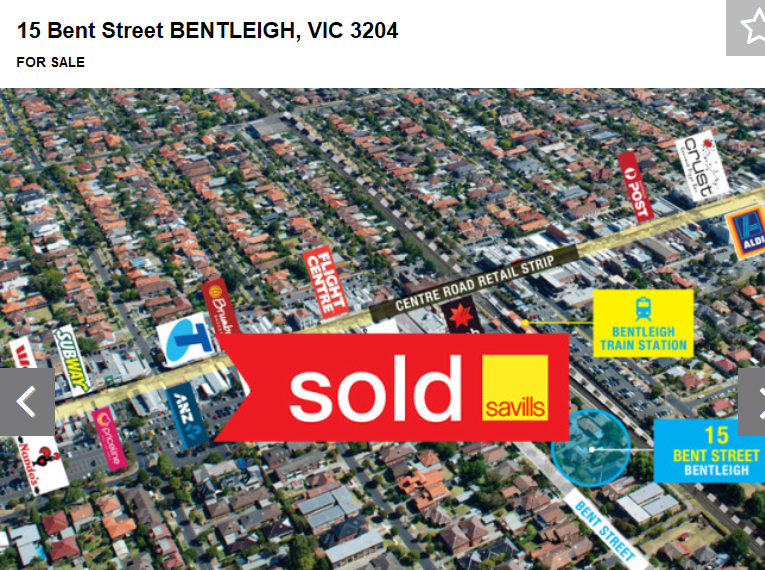
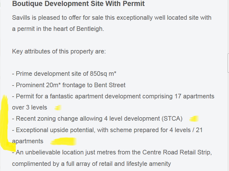
The following report on the Bent Street application is indeed a clue to answering all of the above. Please note that:
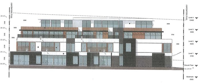
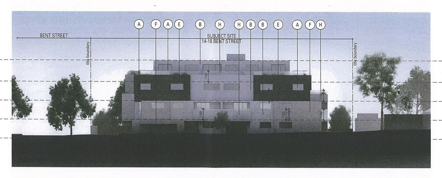 So, is anything changing for the betterment of residents and their amenity? All of these applications will end up at VCAT we predict and unless the planning scheme is reviewed, modified, and greater protection provided via the schedules, and a ‘preferred character statement’ for housing diversity that is made explicit, then we won’t be holding our breath. It is far too easy to blame state governments. Residents should be asking these councillors exactly what they have done in the past 6 months at least, to ‘reform’ the planning scheme. That is their duty, their obligation, and definitely within their powers. Thus far, they have done bugger all except talk of the need to do something! The time for positive action and not mere words is fast running out!
+++++++++
Sounness moved to accept with some changes – setback for south rear side and site coverage to meet ResCode standards. Seconded by Pilling.
SOUNESS: started off by saying that development in Bent St has been ‘subject to a lot of discussion’. ‘Representations’ had been made to councillors about other developments in the street. Sounness did ‘recognise that this is quite a substantial building’ and that 31 dwellings do represent a ‘significant increase into the streetscape’. Said that the housing diversity policy does ‘speak about’ density and this is one of those sites. Went on to say that given the planning scheme and the ‘regulations’ council doesn’t have the ‘ability’ to say that this application should be ‘reshaped’. He thought that this was a ‘fairly acceptable application’ and the conditions are ‘quite reasonable’. Even though he is ‘uncomfortable’ to ‘go down the path of refusal’ wouldn’t ‘be appropriate’ mainly because of the ‘defense point of view at VCAT’. Claimed that there was some ‘difficulty’ with the way that the planning scheme ‘manifests expectations’ and what ‘neighbourhood character should be’. Wanted ‘further discussion’ with officers and councillors about how to address this. Stated that ‘evolving neighbourhood character’ is different to ‘existing neighbourhood character’ and that should be discussed.
PILLING: thought it fulfilled all the ‘boxes’ since it was one step back from McKinnon Road and close to the station. Also meets the 10.5 metre height limit. Said that it is slightly unusual ‘because of the slope’ so it will be part 3 and part 4 storey. ‘It does fit within our guidelines’ and the zone. It mightn’t be ‘perfect’ but ‘in this area’ which is close to transport and shopping ‘this is where we want development to go’. Thought that refusing the application is ‘going too far. It doesn’t warrant refusal’ since it ‘ticks all the boxes’. This is the ’emerging nature of this area’.
OKOTEL: said that her primary objection was that it ‘isn’t in keeping with neighborhood character’ and would like to see applications that ‘fit in more appropriately’ with the area. Referred to 2 previous VCAT decisions and said that neighbourhood character is also something that VCAT ‘considers to be important’ (one in Prince Edward Avenue and in Carnegie). So if VCAT considers something important then ‘so too should our council’. Policies should be ‘applied strictly’. Ended by saying that considering the ‘neighbourhood character in that street’ council should refuse the application.
ESAKOFF: this is ‘further away’ from the Bentleigh activity centre and it’s in the McKinnon Neighbourhood Centre where there should be ‘slightly lesser density’ than at the ‘other end of Bent St’. Supported the proposed conditions to ‘make right the site coverage’ and the ‘northern light’ but it doesn’t address neighborhood character and ‘we’re looking at a flat roof’ where pitched roofs dominate. ‘There are too many things against this’ to give a permit.
HYAMS: said that ‘our job’ isn’t to agree with everything that objectors bring up but to ‘listen to objectors’ and ‘weigh up for ourselves’. Said he understands about the sloping land and that therefore it isn’t really four storeys and ‘under normal conditions that wouldn’t be considered’. He is concerned about the ‘bulk’ and ‘neighbourhood character’. The 10.5 metre height limit was put in because they anticipated that this would give ‘scope for pitched’ roofs and flat roofs that go the whole length does ‘have an impact on neighbourhood character’. ‘There’s no other building in the area that has a flat roof except in the commercial area’ in McKinnon Road. So it’s completely ‘out of character’. Said that since there is this flat roof council can either ‘accept’ or refuse the application as the ‘only alternative’. Said that there were other problems such as site coverage, overshadowing, and setbacks but these have ‘been dealt with by conditions’ so aren’t ‘fatal’ to the application because conditions have seen to them. But ‘bulk and character are fundamental’ and ‘can’t be dealt with by conditions’. At the planning conference people were talking about the impact of the new zones but this has not got anything to do with the zones and Hyams gave the example of Lee St/Nicholson Streets which was ‘built before the zones’ came in. ‘The new zones have nothing to do with this’ and ‘it could have been built under the old zones’.
LIPSHUTZ: was in favour of the application. Thought that the ‘problems’ had been dealt with ‘by conditions’ and that the ‘only issue’ is about the roof. He ‘doesn’t see that as fatal’. He would be more concerned about setbacks and overshadowing. If one house is flat roofed then he doesn’t ‘see’ this as a problem. Said that the application ‘looks like a very reasonable design’ and not too bulky.
LOBO: said that Bent Street ‘all began’ when a real estate company ‘invited an overseas developer’ to invest and ‘big money’ paid for some houses. Plenty of other offers came in and other builders arrived like ‘ants’ after the sugar. They offered to buy mostly from people ready to go to ‘nursing homes’ and ‘necessity is the mother of virtue’. Said that ‘greed’ is destructive and ‘destroys everything’. The application is another example of ‘being ripped open by developers’. Said that Tommy Bent is probably rolling ‘in his grave’ seeing all this destruction. Said that ‘no consideration’ is given to residents about parking, ‘loss of neighbourhood character’ and infrastructure ‘strain’ and schools. The street is ‘reaching a saturation point’ and he ‘hoped’ that the zones ‘would be looked at’ to care for the community. Labor has promised to review and he hoped that ‘they keep up to their promise’. Said he received an email late the previous night about developers trying to sell two bedroom apartments and thought that as a councillor ‘our loyalty should be to residents’ and if he stands for relection in 2016 he couldn’t do this with a ‘clear conscience’ if he isn’t loyal to residents. He stood for election on the promise to oppose overdevelopment so won’t break his pledge.
SOUNNESS: said the planning conference was ‘heated’ and that there needs to be a ‘conversation’ with community about the zones ‘we have at the moment’. In his view if there is going to be density then ‘you put it near a train station’. Said that the Mckinnon station is on a ‘fairly significant line’ even though if people are heading into the city at peak hour they ‘will be standing’ because of the crush. Said that council’s ‘capacity’ to refuse ‘is limited’ because ‘our zones don’t clearly say this is wrong’ and what they do say is ‘that this is the type of thing we want to have’. Said it’s up to councillors to ‘say what we want’. In this case the application is ‘good enough’ so he will support it. He had listened to objectors but thought that there wasn’t the capacity to refuse especially if it went to VCAT.
MOTION PUT AND LOST: voting against – Hyams, Esakoff, Okotel, Lobo, Delahunty. VOTING FOR: Sounness, Lipshutz, Pilling, Magee
Hyams moved motion to refuse permit on grounds of inconsistency with planning scheme; ‘excessive bulk’, neighbourhood character, setbacks, etc. Esakoff seconded.
HYAMS: said there are ‘objective’ and ‘subjective’ elements with town planning. With the objective elements then the application with the conditions meets height limits, parking requirements but ‘where it falls down to me’ is on the subjective parts. Councillors have to look at the ‘subjective elements as well’ to do their ‘role’. Not a question of ‘right decision or wrong decision’ but for him ‘this does not meet neighbourhood character’ for the area. Referred to Bent as being the main property developer of his time.
ESAKOFF: said that she had already stated her objections to the application.
PILLING: ‘acknowledged’ Hyams’ points but that to refuse the application because of the roof was ‘going too far’. Claimed that there were ‘a lot of merits’ with this development . Referred to Lobo’s statements and that councillors ‘are here’ to ‘make sound planning decisions’ and whilst they ‘acknowledge’ residents’ concerns they also have to look at the ‘processes’.
DELAHUNTY: said that she hadn’t spoken previously because she was ‘undecided’ on how to vote and wanted to hear what others had to say first. Even though she often agrees with Sounness this time was prepared to err on the side of caution about neighbourhood character. This is ‘one of those areas where you wish for a different tool’ but the roof doesn’t fit into neighbourhood character. Said that it’s a ‘weird balance’ between ’emerging neighbourhood character and existing neighbourhood character’ and councillors need to ‘understand what our role is’ on this. Said the application shouldn’t ‘mirror’ the shops on McKinnon Road, but the houses in Bent Street. Said that it would be ‘fantastic’ to see applications coming in that are ‘sympathetic to neighbourhood character’. This is right for people to live and is ‘close to a train station’ but you ‘can’t have it all your own way’ and it needs to be ‘sympathetic to the existing neighbourhood character’. So because of the ‘contemporary architectural style’ she will ‘err on the side’ of caution.
SOUNNESS: said that the motions grounds of refusal have about three clauses that speak ‘to the debate’ on neighbourhood character and didn’t think that these are ‘well worded’ . Said that it’s like the councillors saying ‘we don’t like’ what has been put up. It is then ‘a mediation story’. If the motion is successful he hoped that the developer would ‘substantially redesign’ the building. Hoped for a ‘successful outcome with the minimum of risk’.
LOBO: said that ‘it is nice to see the softening of the heart’ and hoped that this could be ‘helped further by the present government’. Answering Pilling Lobo said that ‘we’re not planners but representatives of the residents’ and even if officers ‘recommend something’ that doesn’t ‘mean we have to agree’.
MOTION PUT AND CARRIED. Lobo called for a division.
Voting for the motion to refuse – Hyams, Esakoff, Okotel, Delahunty, Lobo
Voting against the motion – Pilling, Sounness, Magee, Lipshutz
February 24, 2015
Lipshutz, Hyams and Esakoff declared an ‘indirect interest’ and left the chamber.
Moved to accept ‘as printed’ by Pilling. Seconded by Okotel
PILLING: Thought that the conditions imposed by the officers addressed the ‘concerns’ of objectors such as ‘timing, the sound’ plus that the screen is ‘well away from residential areas’. Admitted that this is a ‘different usage’ but with all the ‘checks and balances’ he is ‘supportive of this recommendation’.
OKOTEL: said that there is ‘no designation’ for use of the land so council has to consider the application under ‘planning grounds’ . With the imposed conditions she thought it ‘appropriate’ since the cinema will only happen when ‘other uses are not occuring’. The screen is ‘350 metres away from the nearest house’ and that is ‘quite a considerable distance’ and hence ‘wouldn’t affect the amenity of the neighbours’. The liquor license is ‘available already’ and there won’t be any ‘additional’ licenses.
SOUNNESS: said that he was ‘speaking against the motion’ only because he felt that ‘there should be someone speaking against it’. The racecourse is a ‘site that is somewhat vexed’. Said that the reports and decisions that have ‘come down’ suggest that the operational aspects of the racecourse show that it isn’t ‘always a clean operation’ . He ‘supports’ the motion and the chance of use. Although the conditions ‘seem to be quite useful’ he doubts whether council has got the ‘capacity’ to ensure compliance. Was ‘sure’ that there were answer to such questions about who operates the land.
DELAHUNTY: asked Torres the question about the state of the lease.
TORRES: said he understood that ‘there is no current lease’
DELAHUNTY: would vote in favour but thought that the conditions were ‘perplexing’ since ‘they can’t be met under the current arrangements’. Said that in chairing the planning conference it was ‘interesting to hear the different interpretations of language’ from residents versus the MRC. Said that the department has ‘sent a letter to the MRC suggesting that’ it’s in favour of the permit if the Trust agrees to it. The MRC therefore has ‘interpreted this as under existing use’ and current lease, but there is no current lease. She will vote in favour because she is all for ‘more people using their land’ even though there will be ‘some profit taking’. She hoped that since the conditions can’t be met it ‘forces the parties back to the table’ to negotiate.
OKOTEL: asked whether the conditions imposed would be ‘enforceable’
TORRES: said that for any planning permit that ‘conditions are enforceable’ and that not only by council but that ‘any member of the public can apply’ to VCAT.
LOBO: said he was ‘surprised that the MRC is getting everything’. It’s supposed to be for public park as well as racecourse and ‘we are running short’ of sporting fields. Another ‘sicking point’ was that there is provision for 150 car spaces but ‘they are expecting 500 people’. So are they expecting families or ‘lovers’ to come?
MAGEE: said he doesn’t have any ‘problem with the screen being there’ and the community using the racecourse. He does have a ‘problem with the Auditor General’s report’. One of the recommendations was for a plan to be produced for the racecourse and when the plan is produced ‘it may not be consistent with’ the cinema. This cinema might not be ‘consistent’ with the wishes of the Trustees or the committee of management if it is formed. Said that the condition about Trustee approval means that ‘it must have unanimous approval’ and ‘not a majority of the trustees’ because there is no ‘trust, just a group of trustees’. Said that the Auditor General’s report was ‘scathing’ and he is ‘surprised they haven’t all resigned’. He would have resigned straight off. Said that the Auditor General’s report was ‘instigated’ in part by himself since he had written to the Auditor General. This ‘could be a community asset although there will be some profit taking’ from Crown Land. He has no problem with the MRC because they only do ‘what the trustees allow them to do’. ‘They are a good citizen’ and that ‘they run the racecourse very, very well’. They’ve been ‘allowed to do the wrong thing’ for 150 years. Hoped that things change this year.
DELAHUNTY: wanted Magee to confirm that she hadn’t been misunderstood about whether the conditions were enforceable if the lease negotiations fell apart. Magee confirmed that there was no misunderstanding. Reiterated that the new lease had to be a unanimous decision by all the trustees.
PILLING: acknowledged concerns about governance but this is a planning decision and that the Auditor general’s report was a ‘separate matter’. His decision is ‘purely on planning and he thought there were ‘merits’ to the proposal in ‘allowing community people in there’.
MOTION PUT: LOBO WAS THE ONLY COUNCILLOR TO VOTE AGAINST.
COMMENT
This discussion raises far more questions than providing answers. Here are some:
