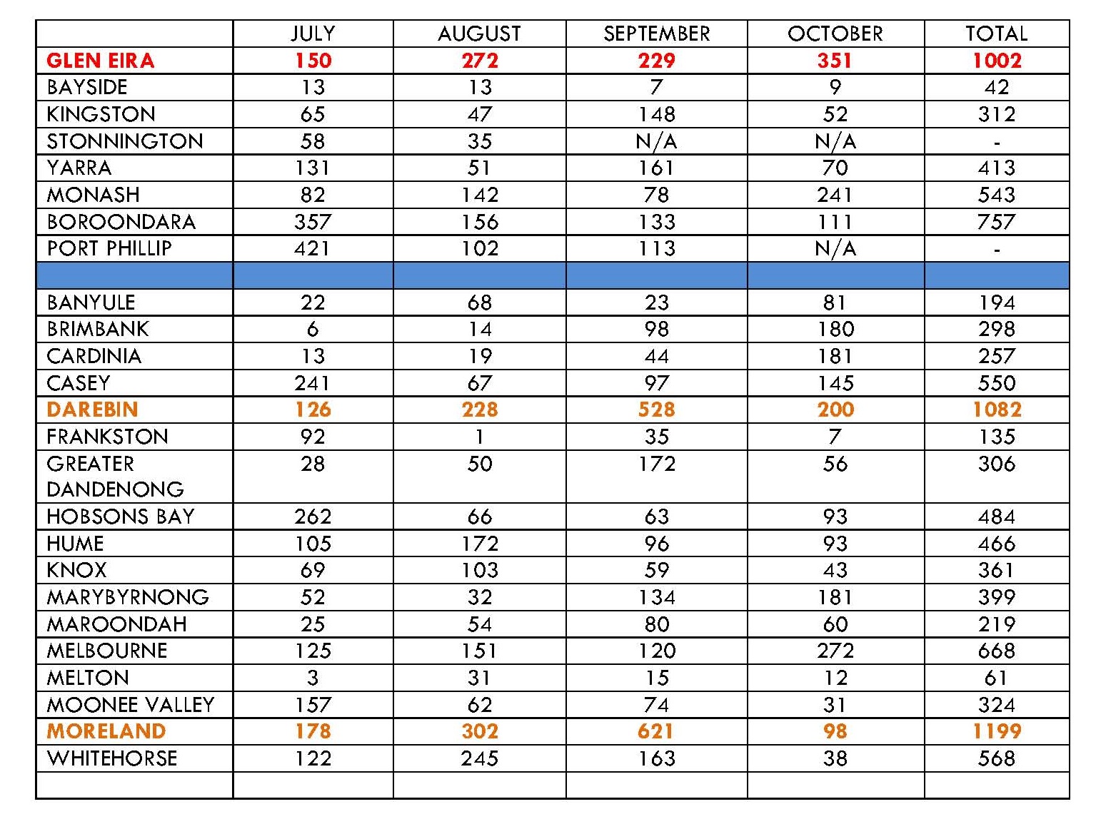
Applications for high density dwellings are going through the roof. Residents are selling up as quickly as they can – often together with their neighbours. Developers are picking the eyes out of all areas now zoned as RGZ and GRZ plus commercial and Mixed Use. And what are our councillors doing about all this? Zilch! Nothing! A big fat zero!
Instead of any firm commitment to review the current planning scheme, (which they legally must) all residents are getting is more of the same hogwash, dissembling and mistruths. Hyams, Magee, Pilling and the rest can repeat ad nauseam that the zones haven’t made any difference. That what is happening now could have happened before. Well, in theory it might have, but the reality is that it didn’t! Apart from a few aberrations in Carnegie and Elsternwick, developers knew that applying for a four storey 20+ apartment block in quiet local streets of normal block size wouldn’t get through. Many got knocked back at VCAT and some even by council. Now with the zones, developers are rubbing their hands with glee knowing that 4 storeys are acceptable, and what’s more, expected. Even more disconcerting is the growing incidence of amended applications going in for additional storeys and units. The latest is today’s publication from VCAT of a five storey amended permit application that increases the number of dwellings by 3. Council had no objection to this increase! This and countless other examples have got nothing to do with the past and everything to do with the current zones which give carte blanche to these increases.
Residents keep being told the same old furphies and to paraphrase Lipshutz citing Goebbels – if you repeat some lies often enough then people might also start believing them. Or at least that is the hope. For example:
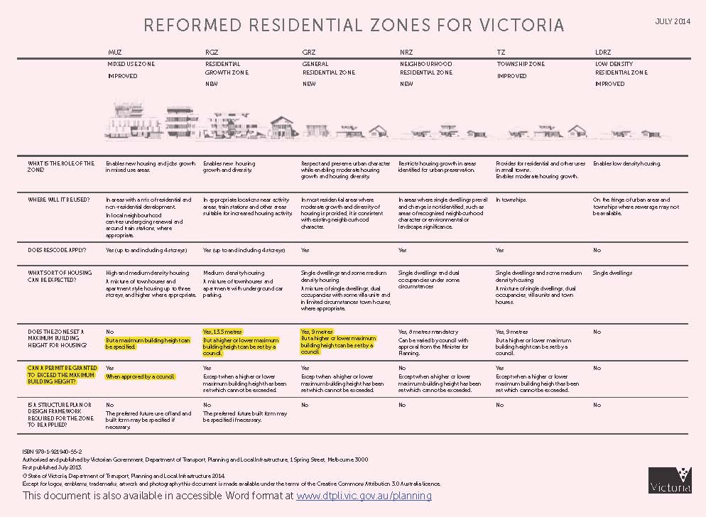
“Glen Eira is the only council with mandatory height limits in the Residential Growth Zone.” What utter rubbish! Stonnington also has a 13.5 mandatory height limit in its RGZ2 Schedule; Latrobe goes even better with a 9 metre height limit in its RGZ2; Greater Geelong has 10.5 for its RGZ2 and so does the Yarra Ranges. How this allegedly super efficient council is ‘ignorant’ of what is going on next door (Stonnington) is not only highly improbable, but totally unbelievable. Yet residents are inflicted with these continual furphies and mistruths.
When other councils (as we’ve previously reported) can exact lower height limits for parts of their GRZ areas or, have lesser site coverage mandates, or greater permeability impostes, and Glen Eira has none of these similar standards, then residents have to start scratching their heads and wondering why this council can keep claiming that they have the best ‘protections’ in the state. Height restrictions are only one of a multitude of standards that could have been introduced or improved upon. That Council has not progressed one iota in terms of the conditions from fifteen years ago is testimony to either how little they tried, or how ineffectual their ‘negotiating’ actually was.
There is no other way of looking at the zones except to say that Glen Eira councillors have failed their constituents – not only because they did not bother to undergo consultation, but more importantly, because officers failed to do the necessary homework and come up with zones and schedules that are based on detailed and current analysis. This is shoddy, inept, and woeful planning and reveals a total disregard for thousands and thousands of residents who are now paying the price for this ineptitude and unfounded arrogance. By doing nothing, by accepting the disenfranchisement of residents, by permitting lax and sub-standard processes to continue, councillors must be tarred with the same brush!
PS: Listed below are some of the latest applications. Poor old Bent St!
64 Bent St – part 3 and part 4 storey building; 31 dwellings; reduction of requirement for visitor parking
27 Jasper Road, Bentleigh – 3 storey, 25 dwellings, waiving of 3 visitor car parking
322 Neerim Road, Carnegie – 4 storey, 38 dwellings
1240 Glen Huntly Road, Carnegie – 6 storey, 118 dwellings, waiving car park & loading bay
4-6 James Street, Glen Huntly – 3 storey, 45 dwellings, visitor car parking reduction