In the ‘community participation’ segment of Tuesday night’s council meeting, one resident got up and said that ‘large trees’ are being taken down by developers before they put in their applications. The resident claimed that two large trees in Hamilton Street Bentleigh had been removed prior to the planning permit application and that he had sent an email to council ‘asking for them to be considered as significant trees’ but hadn’t got any response. He wanted to know ‘how do I go about’ having someone from council ‘come and have a look at it’. Delahunty answered that ‘council currently doesn’t have any tree protection on private land’. Only when someone has applied for a planning permit can council start assessing whether or not there is any ‘significant vegetation’ on the property. Delahunty went on to say that ‘unfortunately at the moment there is no ability for us to protect those trees‘. The resident then wanted it confirmed that ‘there’s nothing we can do’. The developer will cut down the trees ‘and they will be gone’ before he puts in the planning application. Delahunty then asked Torres to ‘detail’ the planning scheme’s ‘anti-moonscaping provision’.
TORRES: said that ResCode allows councils to ‘consider significant vegetation’ that are removed ‘in the past 12 months prior to lodging’ the application and that there are ‘principles around that in not granting a development advantage’.
DELAHUNTY: said that ‘that doesn’t necessarily address what you are talking about’.
RESIDENT: said that the property up for decision that night had a ‘big tree removed’ from there and wanted to know ‘what can be done about that?’
DELAHUNTY: passed this onto Torres and said that she didn’t ‘realise’ that there were any trees involved and that councillors didn’t have any information on that. In the end answered that ‘nothing’ can be done.
DAVEY: asked ‘what can we do?’
DELAHUNTY: said that ‘previously council has considered a significant tree register’ and that many other councils have one. Also that this is something they will ‘consider’ in the future.
RESIDENT: asked ‘how do we go about the process’ for getting council to ‘consider that again?’
DELAHUNTY: said she is a ‘big fan’ of a significant tree register. It’s been part of the last Community Plan but wasn’t ‘enacted at council’. ‘We will have to kick off a Local Law Review’ and that’s when they will start to ‘look at this very seriously’.
HYAMS: asked Torres about ‘this moonscaping development’ how council knows whether large trees are gone before the application comes in?
TORRES: said council has ‘detailed aerial photography’. Plus they get ‘information from the community as well’.
HYAMS: asked the resident when the tree was removed.
RESIDENT: answered that it was removed ‘just before the planning application’ went in on the property.
HYAMS: ‘so theoretically, our officers would have taken that into account’ in writing up their recommendations for the development.
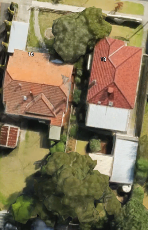
RESIDENT: ‘it’s not been listed on the plans at all’. ‘so it’s just bad luck and they can do what they like’. Said this ‘doesn’t give’ him any ‘hope for the future for the place across the road’. Went on to describe how since all the palm trees along Nicholson St had been removed, the birds are now using these trees in Hamilton and if they go, then there’s nowhere for them.
DELAHUNTY: said she would have ‘another look’ at the aerial shots and ‘maybe it wasn’t significant’
RESIDENT: said the tree was ‘absolutely enormous’.
DELAHUNTY: thanked the resident and said ‘that’s interesting’.
COMMENT
The above ‘discussion’ highlights everything that is suspect about planning in Glen Eira. Apart from the fact that time after time the possibility of a tree register has been defeated by the likes of Esakoff, Lipshutz, Magee, Okotel and Lobo, we find Hyams doing his best ‘public relations’ performance by implying that council officers ‘would have taken into account’ the missing tree in their permit deliberations. It’s very strange then that the officer’s report states – There are no significant trees on the site that would be affected by the proposed development. Thus, did the planning department even bother to visit the site? Did they actually view these ‘aerial photos’. Even a quick search on Google shows large trees across both properties in the application!

Perhaps Hyams and the planning department should be made to answer this very simple question – how many times in the past ten years has council refused to grant a permit on the basis that a tree has been removed? Or even, how many times has the applicant been forced to amend his planning application to encourage the planting of a new tree in the exact same spot that the butchery occurred?
It would also be fascinating to know whether, and how much, council fined Jewish Care over the Wahgoo fiasco when overnight the bulldozers moved in and destroyed nearly 90 trees (including 4 designated as ‘significant’) prior to a permit being granted?
We also need to question why the emphases is on the Local Law (not due for renewal until 2019) and not ensuring that tree protection is part of the Planning Scheme itself. Local laws have far less weight than a provision in the planning scheme. The fact that something is in the Planning Scheme also ensures that residents have objection rights and can go to VCAT if they so decide. Depending how the Local Law is written, there may not be any objection rights whatsoever! Nor would residents have to wait 2 years for the law to be reviewed. An amendment could be started immediately – that is, if council really had the will. A simple copying from other councils should not take too much officer time!
Davey’s question is also disappointing. Doesn’t she really know what is possible? Doesn’t she work for Boroondara which has a tree protection policy? Or is she playing Dorothy Dix here? Either way, after 8 months as a councillor, and a Green, surely she should be aware of the options? Boroondara even allows the ordinary Joe Blow to nominate a tree for the register – https://www.boroondara.vic.gov.au/waste-environment/trees-and-naturestrips/nominate-tree-recognition-and-protection
Plus there’s also this latest move from a resident in Bayside to protect her peppercorn trees once the property is sold to a developer – See: http://www.heraldsun.com.au/leader/inner-south/bayside-council-lists-sandringhams-susan-st-peppercorns-on-their-protective-significant-tree-register/news-story/c8b1172df081b566ba92cb903a05bcb7
New councillors have overall been most disappointing. Goes to show how promises to represent the community all too often and quickly disappear into thin air once elected. Much can and should be happening right now. All it takes is for 5 councillors to have the gumption to get up, move a resolution and have it passed. Of course that would require Glen Eira joining every other council in the state and having what it known as a Notice of Motion – repeatedly defeated by the likes of Lipshutz, Hyams, Okotel, Esakoff, Ho and Tang.