GE Planning


Another objective of Council is to promote the integrated planning of the city. Integrated planning involves working with the community, residents, traders, service providers and other stakeholders to enhance the quality of Glen Eira’s suburbs and their environmental, economic and social sustainability. Integrated planning involves looking beyond traditional town planning solutions. It is important to encourage people to participate in the development of their city and to develop overall visions and plans for areas. It involves holistically looking at a wide range of issues in the local community including; infrastructure, social planning, economic development, recreation and capital works.

The above quote comes from Council’s Planning Scheme. Given recent history and the manner in which the new residential zones were introduced, we decided to see what other fiction the scheme contained.

Councils are meant to ‘regularly review’ their schemes and this basically means every four years following council elections. The purpose of such reviews is to determine whether the schemes are up-to-date; whether they are aligned with council’s strategic direction, and whether they are in keeping with state provisions.

Glen Eira’s planning scheme has not been genuinely ‘reviewed’ for eons. It is a ‘fossil’ parading as a robust and contemporary document. Featured below are extracts from the scheme. It is frankly incomprehensible how a document of this importance is allowed to exist when so much of what it contains is:

  • Decades out of date
  • Full of promises that have not been fulfilled, and perhaps were never intended to be actioned.

The document itself is a damning indictment of this Council. Reference documents go as far back as 1996 and have not been touched since; data is obsolete; motherhood statements abound and most importantly, nearly everything that is promised under the guise of ‘further strategic’ actions has simply not been done – especially in terms of protecting trees, parking precinct plans, structure plans, etc. In short, the planning scheme is worthless as a document that provides a clear vision and action plan that residents can have full confidence in.

Here are some of the empty promises quoted verbatim –

There have also been growing resident concerns over loss of trees associated with multiunit development. Despite Council’s efforts to encourage tree retention and adequate landscaping, planting is generally limited and has little consideration for the character of gardens within the street/neighbourhood. The cumulative effects of adjacent, multi-unit development have been a loss of the tree-filled semi-private spaces that contribute towards Glen Eira’s image as a garden suburb.

Minimising the demolition of buildings/site clearing prior to seeking development approval.

COMMENT: No local law on tree protection; no significant tree register after at least a decade of public outcry; and when this issue came up at a council meeting, councillors resolved to do nothing since the planning scheme, it was claimed, provided sufficient protection.

See: https://gleneira.wordpress.com/2013/10/16/still-going-round-the-mulberry-bush-10-years-on/

https://gleneira.wordpress.com/2013/10/14/the-saga-of-the-tree-register/

https://gleneira.wordpress.com/2011/10/04/the-non-existent-tree-protection/


STRATEGIC FRAMEWORK

The Glen Eira Community Plan identifies the corporate direction of Council over a 3 year period (2001-2004). Many of the objectives and strategies identified in the Municipal Strategic Statement have originated from actions identified in the Community Plan.

To ensure integrated neighbourhood planning of Glen Eira’s suburbs.

Facilitate high quality urban design and architecture that will enhance neighbourhood Character

Identify a preferred future character for housing diversity areas.

Ensure residential development in commercial areas does not contribute to traffic and car parking problems.

Ensure that the community is involved in decision making about their neighbourhood.

Ensure that the traffic impacts are adequately addressed when considering new residential development.

FURTHER STRATEGIC WORK

Developing local structure plans / urban design frameworks to guide development in the neighbourhood centres.

Investigating a vegetation management program which considers appropriate controls and guidelines to ensure vegetation protection.

Developing “suburb” plans for each suburb which integrate land use and development planning, with planning for infrastructure, capital works, recreation, parks and gardens, street trees and business development.

Developing local area traffic management plans and parking precinct plans to control the effects of parking and traffic intrusion in residential areas.

Investigating mechanisms which require developers to undertake street tree planting.

Ensure that adequate standards are set for on-going maintenance of public space at commercial centres.

Levying development contributions to finance improvements and additions to physical infrastructure including drainage and public open space, where new development is likely to impact on the capacity of existing infrastructure.

Ensuring that impervious surfaces are minimised in areas which are prone to flooding.

Investigating the development of additional development contribution mechanisms based on accepted principles of need, equity, nexus, accountability and timing.

Preparing a Municipal Stormwater Plan incorporating a Drainage Framework Plan.

Parking precinct plans

The City of Glen Eira recognises the special and often conflicting parking needs of its numerous commercial centres. Further strategic work is necessary to develop Parking Precinct Plans to:

􀂃 Maximise the supply and usage of parking for customers and traders of the centres.

􀂃 Limit the requirements for car parking for new development, whilst minimising adverse parking and equity consequences of new developments.

􀂃 Guide Council in the provision of public car parks.

Applying the Public Acquisition Overlay to properties identified by Council as being necessary for the provision of off street car parking in order to reserve land for that purpose and to ensure that changes to the use or development do not prejudice the purpose for which the land is to be acquired.

􀂃 Preparing Parking Precinct Policies for the following neighbourhood centres:

􀂂 Alma Village, Caulfield Park, Caulfield South, Bentleigh East, Glen Huntly, Ormond.

􀂃 Investigating the need for a cash-in-lieu policy to fund new car parks in various commercial centres.

MONITORING AND REVIEW

A review of this planning scheme will be undertaken at least every three years.

++++++++++++

And here are the ‘reference documents’ included in the scheme. Please note the dates.


Housing and Residential Development Strategy, Glen Eira City Council, 2002

Urban Character Study, Anne Cunningham & Anne Keddie, 1996

Urban Village Structure Plans, Glen Eira City Council, 1999

Phoenix Precinct Urban Design Framework, Gerner et al, 1998

Glen Eira Neighbourhood Character Review Final Report (March 2011), Planisphere

Economic Overview, Henshall Hansen & Associates, 1997

Glen Eira Retail/Commercial Strategy, Essential Economics, 1998

City of Glen Eira Business Development Strategy, 1998

Urban Village Structure Plans, Perrott Lyon Mathieson P/L, 1997

Phoenix Precinct Urban Design Framework, Gerner et al, 1998

Glen Eira Heritage Management Plan, Andrew Ward & Associates, 1996

Melbourne Water Drainage Survey, Melbourne Water, 1998

Glen Eira Drainage Strategy, 1998

Glen Eira Furniture Strategy, 1997

Undergrounding Infrastructure Policy, 1997

Glen Eira Traffic Management Strategy, 1995

Revised Warrants for Local Area Traffic Management Measures, 1998

Draft City of Glen Eira Parking Policy, Andrew O’Brien & Associates, 1998

Review of Car Parking Provisions in Victorian Planning Schemes –Final Report. Car Parking Advisory Committee, 1996

Urban Village Structure Plans, Perrott Lyon Mathieson, 1997


IMG

IMG_0001

neerim3

kokarib

mavho

neerim

truganini

morton avenue

Untitled

The Age has run a series of articles on the new residential zones and how decisions appear to be based not on sound strategic planning, but political back room wheeling and dealing. The upshot is that Labor held municipalities, have received the raw end of the deal, whilst those Liberal strongholds of Glen Eira, Bayside and Boroondara allegedly got away with blue murder. Or so it is claimed by Labor.

The Minister’s Standing Advisory Committee produced ‘reports’ which either endorsed the various councils attempts to introduce their zone amendments, or canned them and recommended non-acceptance. Moreland, Darebin, and Kingston in particular, received the thumbs down. Reading these reports our conclusions are:

  • That many of the committee’s criticisms of these councils apply equally to Glen Eira
  • That the amendments of these councils were in many respects far superior to anything produced by Glen Eira
  • That politics and manipulation had a very strong role in what happened.

We’ve gone through some of these reports and include the relevant extracts below. We ask readers as they peruse these offerings to keep the following facts in mind:

  • Glen Eira’s so called Housing Strategy dates back to the dark ages
  • Glen Eira’s amendment was passed prior to the release of the Victoria in Future 2014 population figures – so ‘significant’ in the committee’s denunciation of some councils.
  • Plan Melbourne also does not feature in the Glen Eira approach
  • Glen Eira has admitted that in the past the housing diversity/minimal change dichotomy only resulted in 56% of dwellings going into housing diversity
  • And even with all these ‘presents’ Glen Eira still couldn’t get it right!


MORELAND

The Committee appreciates that Council has had to promptly respond to the changing policy framework and consider how Plan Melbourne should guide the application of the new residential zones in Moreland. The updated Victoria in Future population and dwelling forecasts for local government areas to 2031, released in early June 2014, indicates that Moreland will have significantly more demand for housing than was previously anticipated. It is against this background that the Committee has undertaken its review of the draft Amendment.

In relation to Council’s submission that the RGZ has been used to provide a transition between the core commercial areas, the zone has only been applied to three percent of the R1Z land and there are many instances where this is not the case, and the Mixed Use/Commercial Zones will directly abut NRZ. The Committee is not satisfied this has been consistently applied. Whilst it may be argued the built form outcomes are adequately dealt with in the Structure Plans, it needs to be recognised these primarily relate to Commercial/Mixed Use/Activity Centre Zones which may attract quite different types of development.


KINGSTON

Council submitted that its starting point for the draft Amendment was that the strategic objectives of increased housing diversity and incremental housing change, as already established in its planning scheme have worked successfully over the past 14 years and that with refined parameters proposed they will continue to do so in the future.

Firstly, the Committee agrees with Council that its existing strategy appears to have worked generally well for the time in which it was established and has been implemented. This is evidenced in the general harmony and balance that Council submitted had been achieved through limited applications needing to be referred to a full Council meeting and a relatively low appearance rate at VCAT. The Committee also considers Council has undertaken an excellent job of monitoring where housing has occurred and seeking to understand where housing change is occurring.

Council’s submission however, acknowledged that the change in housing form over the past 14 years varied between suburbs, and was not directly linked to existing zone application. The Committee’s review of mapped developments provided by Council against the existing R1Z and R3Z zoning confirms this. The areas that have experienced greater change in housing form appear to be more closely correlated with the proximity to public transport and services, rather than with the zone boundaries. This raises a question to the Committee that there may be a need to review whether the boundaries identified in 2000 for incremental change and housing diversity, that then led to the R1Z and R3Z zones, require review. The Committee understands the boundaries of the policy and subsequent zone application have not been comprehensively reviewed since 2000.

The Committee’s review of the 2000 Strategy is that the policies set out in the 2014 KRSU are not simply an update of the 2000 strategy, but a new strategy in format, content and direction. This is not itself a criticism of the KRSU, but the Committee considers it is a misnomer to refer to the new strategy as an update, when there has been 14 years of housing and policy change occurring in between. This is particularly concerning when the general mapping between what was R1Z and R3Z has not been comprehensively reviewed.

As Council put to the Committee on many occasions in its submission, planning is the sum of many parts. The Committee agrees. Therefore, whilst the Committee accepts the detailed and extensive work Council has undertaken in monitoring supply and modelling this into projected demand, this is only one part of the planning process. To demonstrate that a strategy is sound and robust the Committee considers it needs to do more than demonstrate it can accommodate projected population forecasts. It also needs to demonstrate that a choice of housing can be provided that offers affordable options and in accessible locations. This is consistent with Plan Melbourne as put by various government agencies at the hearing.

The Committee considers that the update or review of the 2000 residential strategy needs to more extensively consider the broader policy changes that have occurred in the past 14 years.

Council has not reviewed most its neighbourhood character strategy since 2000 and has not comprehensively reviewed the boundaries of where R1Z and R3Z as part of a housing strategy that addresses choice, affordability and character issues

There does not appear to have been a comprehensive review of these boundaries since 2000 and the Committee was not referred to any comprehensive update to the Neighbourhood Character guidelines since this time that identify areas where application of the NRZ over the GRZ is substantiated. It may be that there are areas within the existing R3Z that warrant use of the NRZ, but the Committee considers simply applying the NRZ to all R3Z areas in the manner proposed is not strategically justified.

Council submitted that its approach to the new zones was more resolved and better justified than other neighbouring municipalities, notably Glen Eira and Bayside. The Committee is aware that the Amendment to implement the zones at Glen Eira was undertaken by the Minister for Planning in accordance with 20(4) of the Planning and Environment Act 1987. It also understands that an Amendment has been prepared to introduce the zones into Bayside City Council, but this Amendment has not yet been approved.


DAREBIN

The Committee concludes:

 The housing needs of Darebin are 630‐680 new dwellings each year to 2031.

 The proposed residential zones in conjunction with non‐residential zone housing growth will broadly have the capacity to accommodate this housing need. However this, in itself, does not result in justification for a broad‐scale use of the NRZ.

The wider use of the NRZ results in it being applied to 36 percent of all residential areas whereas under the HCFP it would have been around 23 percent. The Committee sees this as a significant variation and the basis of this variation should be reviewed against the principles and criteria of PN78 with reference back to the zone purpose.

MOONEE VALLEY


This in itself indicates an urgent need to review the Housing Strategy to ensure it can appropriately respond to the opportunities of the new residential zones and provide a strategic basis for their implementation. It would also provide an opportunity to refine the housing and population data to ensure that the most relevant, up‐to‐date picture of likely future growth is at the core of a new assessment of housing needs.


The Committee concludes that a sufficient number of dwellings may be provided to meet the projected needs of the future population under the proposed allocation of zones. However this does not address whether the types of housing resulting from this growth will meet the market needs for the various housing types.


Source: – The various committee reports may be accessed at: http://www.dtpli.vic.gov.au/planning/panels-and-committees/current-panels-and-committees/residential-zones-standing-advisory-committee


Labor to review Coalition residential zones overhaul

Date:November 6, 2014 – 6:51AM

Planning Minister Matthew Guy’s revamp of Melbourne’s residential zones could be overturned if Labor wins this month’s state election, with the opposition promising a major review of the new rules.

Mr Guy warned the review would be the first step in Labor tearing up the new zones in a bid to “bring back Melbourne 2030“, the controversial planning doctrine rolled out by the Bracks governments from 2002.

Mr Guy has approved new planning zones for 22 of Melbourne’s 31 councils.

The new zones divide suburbs into streets deemed “no-go”, where nothing over two levels can be built, “slow-go” where up to three levels is permitted, and “go-go” areas where up to four levels is allowed.

Councils have put forward their plans for where high-density development should be banned – but those in the city’s leafiest suburbs have had greater success in convincing Mr Guy to sign off on their proposals.

Glen Eira Council covers suburbs including Elsternwick, Bentleigh, Caulfield and Ormond. It has had 80 per cent of its municipality placed in the “no-go” zone where only two-level development was allowed.

Darebin Council, by comparison, asked for 36 per cent of its suburbs to be placed in this “no-go” zone – but last week learned it had got only 10 per cent.

Labor will on Thursday pledge to review what it says is the “botched” process of rolling out the new zones across Victoria.

Labor’s planning spokesman Brian Tee said Darebin showed decisions on the new zones had been heavily politicised.

The new zones had, he said, “distorted growth and planning by forcing intensive high-rise development in some areas, while locking up leafy Liberal suburbs”.

He said Labor’s review of the planning zones would include an examination of the consultation process and the role of Mr Guy and his office in it, and how the new zones had looked at the housing needs of the state.

But Mr Guy said Labor’s “review” would see the zones already rolled out, which had protected suburbs like never before, thrown away.

“Labor wrecked our suburbs when last in government, and by ‘reviewing’ the Neighbourhood Residential Zone, they’ll do it all over again under Daniel Andrews,” he said.

Labor’s pledge to review the zones came as a Greens candidate for the inner Melbourne seat of Northcote said the new planning rules had treated suburbs in Melbourne’s less conservative suburbs differently to those in Liberal electorates.

Trent McCarthy, who is also a Darebin councillor, said Mr Guy had played a “cruel joke” on residents by rejecting the controls proposed by Darebin Council. It had left many neighbourhoods exposed to “over-development”, he said.

Planners though were circumspect about Labor’s pledge to review the zones.

A group of high-profile planners have opposed the new zones because they restrict development and force medium and high-density housing into smaller pockets of Melbourne.

One outspoken planner, Colleen Peterson from Ration Consulting, said there was “every chance Labor’s proposal will make it worse not better”.

“This isn’t the great salvation – it’s going to play more into the common public perception that residential development is a bad thing,” Ms Peterson said.

She said planning a city should be “just like collecting taxes and building roads – governments have to make decisions for the greater good. It’s not a popularity contest”.

Swinging voters could knock Denis Napthine out in Melbourne’s planning zones

Date
November 6, 2014 – 7:06AM
Concerns: Danita Tucker in Jasper Road, McKinnon, where residents are dismayed by developers' plans to build three-storey apartment blocks. 
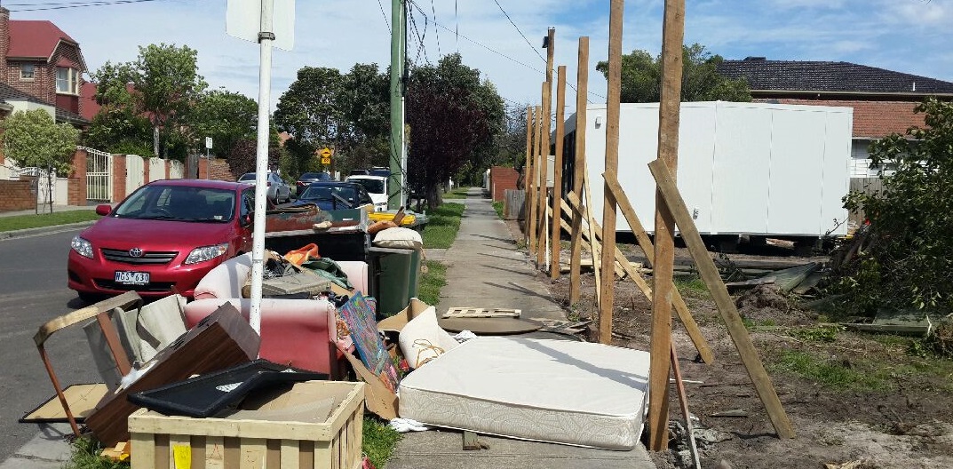
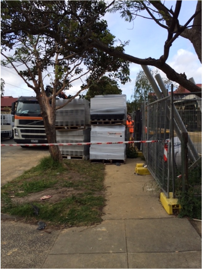
Concerns: Danita Tucker in Jasper Road, McKinnon, where residents are dismayed by developers’ plans to build three-storey apartment blocks. Photo: Penny Stephens

She doesn’t look scary, but there are few people the Napthine government should fear more than someone like Danita Tucker. “I’m a swinging voter,” says the mother of two who lives with her family in a quiet Bentleigh street.

It’s a marginal electorate, held by the Liberal Party by just 0.9 per cent, and one that helped deliver government to Ted Baillieu in 2010.

Bentleigh is among a clutch of seats that could help hand power back to Labor this month.

If the electorate does switch to Labor, the new government will have planning – the perennial debate in Melbourne’s suburbs – to thank for it.

Like the seats of Mordialloc, Carrum and Frankston, Bentleigh is one four marginals strung along the Frankston train line. The suburbs within these seats are not normally known for their political combat.

But, thanks to changes Planning Minister Matthew Guy started putting through last July – and still far from complete – there is an increased focus on urban development.

The new residential zones Guy has begun ushering in have been planned by consecutive governments over the past decade, and have now been introduced to 22 of Melbourne’s 31 council areas. The rollout has been messy, confusing, and has sparked anxiety for many residents.

But the three new zones were an attempt to drastically simplify the planning system and provide certainty – so residents know exactly what’s allowed in their street.

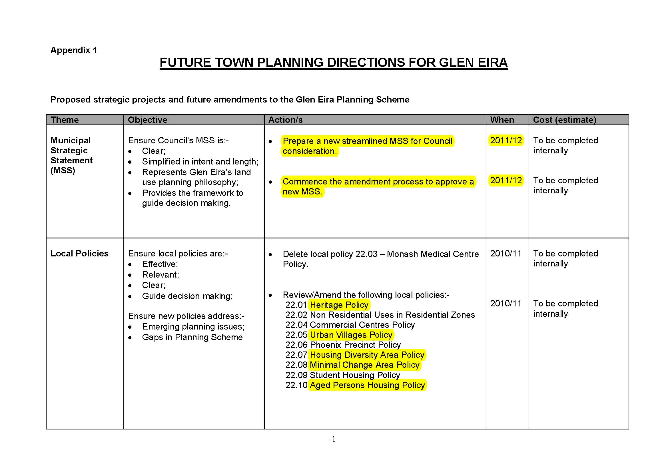
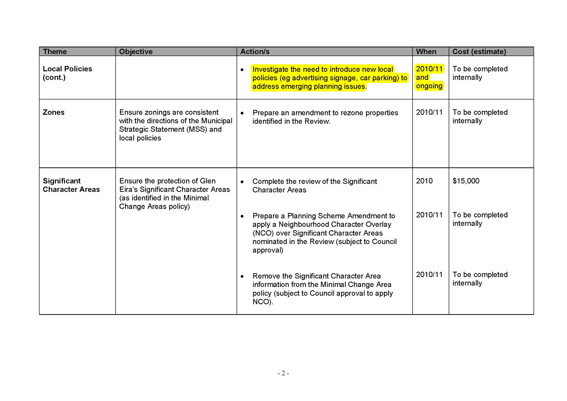
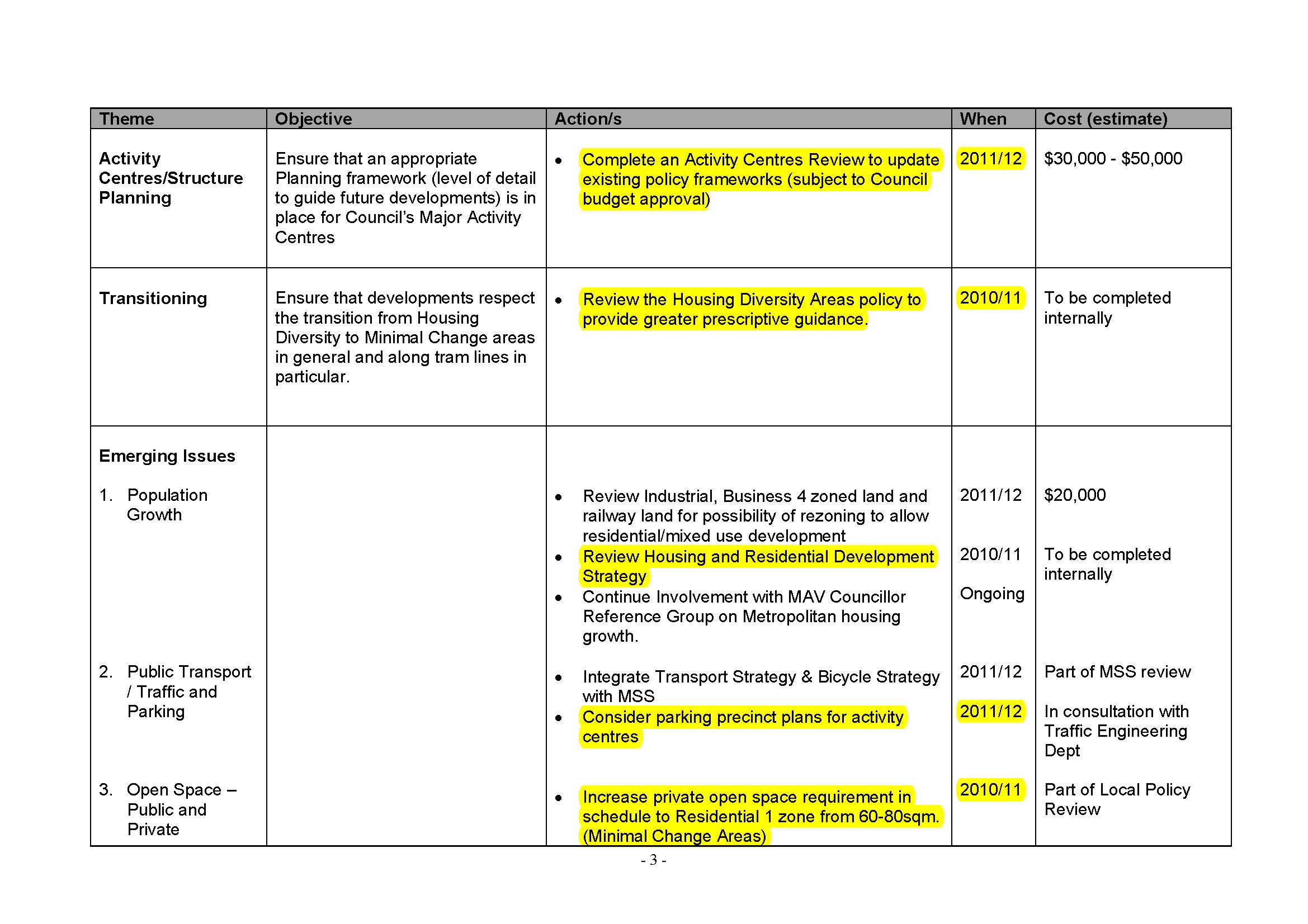
Glen Eira, the council covering Tucker’s area, was the first cab off the rank in Guy’s rezoning of residential areas into three zones: “no-go”, “slow-go” and “go-go”.

The “no-go” zones are called Neighbourhood Residential Zones. They restrict housing development in areas deemed urban preservation zones, and limit development to just two storeys.

Glen Eira had a remarkable 80 per cent of the council’s areas deemed worth preserving.

It compares with just 11 per cent on the other side of the city, in Darebin Council in the city’s north that covers areas including Northcote, Thornbury Preston and Reservoir.

The “slow-go” zones were applied to areas like Tucker’s, where “moderate housing growth” would be allowed, with buildings up to three levels.

In the seat of Bentleigh, the zoning has caused an outcry. Suddenly, residents in the streets surrounding the train line have found themselves pitted against developers wanting to build three-storey apartment blocks.

The new  rules theoretically changed little from existing land zoning. In reality, they removed any uncertainty about what a developer would get, either from the council or the state planning tribunal.

Newly formed resident groups say the changes are now having significant a impact. In a fortnight, Save Our Suburbs will hold a specially convened forum in Bentleigh on the zones.

Residents are concerned because, in the year since the new rules came into the area, several single-level, post-war cottages that have long defined the character of suburbs such as Bentleigh have been bought by developers.

They are to be replaced by townhouses and apartment blocks to house some of the 1.6 million extra dwellings the government’s Plan Melbourne strategy says will be needed by 2050.

“Developers weren’t really interested in this area until they saw there was a set height limit,” says Tucker, who is watching in amazement as her neighbours houses sell for medium-density housing. Every day flyers come through Tucker’s letterbox from real estate agents.

She says there is “an annoyance at our local member because she has not been looking after the needs of her local community”. The zones, Tucker says, were “just imposed upon us without any engagement”.

That local member, the Liberal Party’s Elizabeth Miller, supported the zones for Bentleigh.

She argues the changes have meant councils are now truly the planning authority for their area, deciding where development is appropriate.

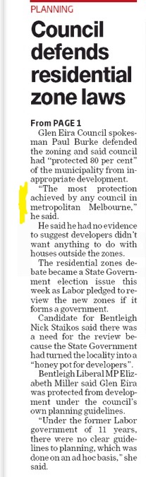
“Glen Eira Council has identified 80 per cent of the municipality is now protected from development under the council’s own planning guidelines,” she says. “Under the former Labor government of 11 years, there were no clear guidelines to planning, which was done on an ad hoc basis.”

Labor’s candidate for the area is Nick Staikos. He says the zoning changes have turned Bentleigh “into a honey pot for developers”.

Staikos is doing a lot of door-knocking and jokes that the zones have had an upside for him in the development rush: “I’m finding there’s a developer or a real estate agent who’s been here just before me – residents are relieved I’m a politician.”

Glen Eira is among a lucky few councils – Bayside and Boroondara are the others – that were major beneficiaries of the zoning changes, with Guy locking up all but 20 per cent of each of the well-to-do councils’ suburbs from developers wanting to build anything above two levels.

While other councils like Darebin, Moonee Valley, Darebin and others were less fortunate, Guy boasted last week on ABC Radio he had introduced the toughest zoning laws in the country.

“Around 80 per cent plus [is] in the most restrictive zone in Australian residential zoning history, the government’s new neighbourhood residential zone.”

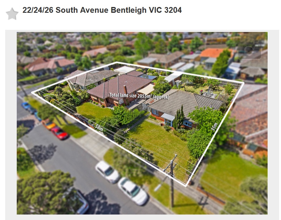
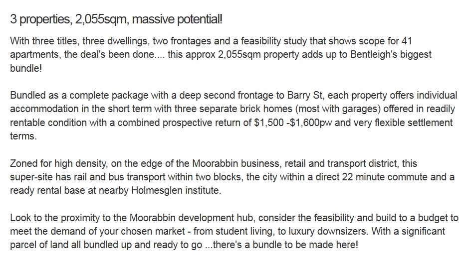
Guy wasn’t so keen to talk about the small pockets in places such as Bentleigh, Moorabbin, Highett and Cheltenham now facing what is known as the “go-go” zoning – the Residential Growth Zone.

These are areas where residential streets near train lines and busy shopping strips have been, or are to be, rezoned to allow developments of at least four storeys. There aren’t many in the marginal Bentleigh electorate affected by this.

But across the rail line from Bentleigh is the far safer seat of Sandringham, held by Murray Thompson – son of a former premier Lindsay – by a margin of 15.6 per cent.

It is in the council area of Bayside. There, while the richest suburbs like Brighton and Sandringham have largely received the highest level of protection from “over-development” available in Australia, the less wealthy have been put into this pro-development category.

A drive around the streets affected by these proposed new zones in Cheltenham, Moorabbin, Highett and near the long-promised new Southland railway station shows why many residents are anxious.

Typical is Highett’s Major Street, a quiet dead-end so narrow the rubbish truck can’t turn around and has to reverse out each week. It has a few new two-storey townhouses, but most of its 20 houses are single level.

On one side of the street – the side to be rezoned for up to four-level development – every house bar one has a sign Melbourne has seen before: “We Will Oppose Inappropriate Development.”

Gary McCulloch bought in Major Street two years ago “because it was a very quiet, family-oriented street that was organically regenerating”, and now fears he will soon have an apartment tower looming over him.

McCulloch doesn’t know who to blame for the zoning that could soon be finalised on his street: Bayside Council or the minister. They blame each other.

But he’s sure of one thing: “None of this is based on sound planning principles, and it is a result of political interference from the state government – there are no votes for them here or in Cheltenham. They wouldn’t dare upset their blue-blood constituents in Brighton.”

Bayside mayor Laurie Evans says the council was forced to choose the high-growth zones after Guy’s chief of staff demanded the council select areas along the Frankston railway line.

Guy argues the zones have provided people with certainty, protecting large areas of Melbourne from inappropriate high-rise development.

He says Labor had never accepted responsibility for some of the problems created by the “anything-goes Melbourne 2030 policy”. He argues its push to consolidate Melbourne into its existing boundaries fuelled inappropriate overdevelopment.

Labor, for its part, on Thursday revealed that if it was elected it would complete a major review of the zoning changes.

“Communities right across Victoria are complaining that they were not consulted,” Opposition planning spokesman Brian Tee says.

“Outcomes have been forced on them with many residents believing the changes to what can be built in certain areas is political – some suburbs have been protected and development has been pushed elsewhere.”

Perhaps most surprisingly in the debate around the zones in the bayside areas is that, while residents are unhappy, developers are equally dissatisfied. A group of them, represented by high-profile planning barrister Nick Tweedie, SC, last month told a planning department committee considering the new high-growth zones that they would have preferred them to be in more affluent bayside areas.

James Larmour-Reid is president of Victoria’s Planning Institute, which backs the new residential zones as a means of managing growth and change across Melbourne. Larmour-Reid says the new zones, after a decade of debate, have provided a method of implementing “go-go”, “slow-go” and “no-go” areas in council housing strategies.

But he says that missing from the plan to push forward with the residential zones was “an overarching metropolitan housing strategy”. It was also unfortunate that the government’s Plan Melbourne strategy had been released only after the new residential zones had started to be rolled out.

Larmour-Reid says it is  “too early to make a call on whether or how the new zones are shaping development proposals in particular locations” because the housing market is constantly evolving.

Questioned over suburbs such as Bentleigh seeing a surge of applications for medium-density development, he says these sorts of projects were always possible under the old zones.

And, he says, medium-density development might just be something Melbourne has to start getting used to.

“Apartments are now being constructed at greater distances from the CBD in places like Mitcham, Glen Waverley and Preston.”


PS – and the Labor Party Media Release –

LABOR WILL TAKE THE POLITICS OUT OF PLANNING

 An Andrews Labor Government will review the botched planning zones imposed on councils and allow communities to have their say.

The Napthine Government has distorted growth and planning by forcing intensive high-rise development in some areas, while locking up leafy Liberal suburbs. Under Labor’s plan, new planning zones will be reviewed with a full report tabled in Parliament. The review will examine:

• The Napthine Government’s consultation process •
  • The role of Planning Minister Matthew Guy and his office in that process
  • • Departmental advice on zone application and what weight is given to heritage, local character and the housing needs of the state
  • • The impact of the zone changes on our suburbs
  • • Alternative ways to meet our housing needs
  • • How the zones can better fit within the framework outlined in Plan Melbourne Quotes attributable to Mr Tee “The Liberals can’t say they support growth and development in Melbourne if they target suburbs based on their politics.” “Under the Liberals, local councils are getting trampled over, the community doesn’t have a say and some of our oldest and most vibrant neighbourhoods are facing the wrecking ball.” “Labor will take the politics out of planning. We’ll meet the housing needs of our future but we’ll take communities and councils with us.”
  • Key Facts
  • • Plan Melbourne, the Napthine Government’s vision for Melbourne to 2050, outlined the need for 1.6 million houses to keep pace with population growth.
  • • The Napthine Government’s new zones were released before Plan Melbourne was released.

Untitled

Land is over 2000 square metres and zoned GRZ

Listed below are some of the latest planning applications yet to be decided. We draw readers’ attention to the following:

  • The number of requested car parking waivers
  • The lack of detail provided in council’s register (ie ‘multi-unit development’). The legislation requires that council publish what the proposal states. It is entirely inadequate that a phrase such as ‘multi unit development’ meets this requirement. If this is all that was submitted, then it should never have been accepted. If the application is far more detailed, then council needs to publish the details in full.

BENTLEIGH

14-18 Bent Street – Construction of a four (4) storey building comprising of 55 units (above basement car parking)

477 South Road – The construction of a four (4) storey building comprising of five (5) dwellings and a shop and reduction of the car parking requirements for the shop use and visitor car parking

85 Robert Street – Construction of a three (3) storey building (above basement level) comprising of ten (10) dwellings and a reduction of the associated visitor parking requirements

CARNEGIE

14-16 Elliott Avenue – Construction of a four storey building comprising twenty-one (21) dwellings (above basement car parking) and a reduction in the associated visitor car parking requirements

5 Tranmere Avenue – The construction of a four (4) storey building comprising of twelve (12) dwellings

ORMOND

2 Ormond Road – Construction of a three (3) storey building above basement car park comprising of 15 dwellings

2 Ulupna Road – The construction of a three (3) storey building comprising of sixteen (16) dwellings with basement car parking

CAULFIELD NORTH

90 Hawthorn Road – Construction of a three (3) storey building (above basement level) comprising of twenty-six (26) units and alteration of access to a road in a Road Zone, Category 1 on land affected by the Special Building Overlay

97-93 Hawthorn Road – Construction of a five storey building comprising of a shop and up to eighteen (18) dwellings; reduction of car parking requirements associated with the shop and a waiver of loading bay requirements

1A Orrong Crescent – Construction of a four (4) storey building comprising three (3) shops and eighteen (18) dwellings above basement car parking; reduction in car parking requirements and waiver of the loading bay requirement

BENTLEIGH EAST

817-819 Centre Road – Construction of 26 apartments, associated reduction in carparking and alteration of access to a road in a Road Zone Category 1

908 Centre Road – Multi unit development

2 Malane Street – Construction of a three (3) storey residential building comprising eleven (11) dwellings

CAULFIELD

307 Hawthorn Road – Construction of multiple dwellings on a lot, alteration of access to a road in a Road Zone Category 1 and a reduction in the visitors parking requirements of the Glen Eira Planning Scheme


In return for 2046 dwellings (at this stage) which will comprise the Caulfield Village, our great negotiators exacted the paltry sums of 4 and 5 percent as the open space contributions. We estimate that this will provide a return of around $5 to $6 million by the time the money starts rolling in. Similar, long term ‘negotiations’ have taken place over the Moonee Valley Racing Club’s development plans.

Matthew Guy recently gazetted the amendments necessary – declaring the area the equivalent of a Priority Development Zone and, also similar to Caulfield, the creation of an Incorporated Plan approach. An Advisory Committee had been set up to consider the proposals and public hearings were held over ten days. Guy admittedly over-rode many of the committee’s recommendations regarding height and density. However, the following conditions were exacted from the racing club and outstrip by light years what our wonderful negotiating team achieved. We cite directly from the council minutes and remind readers that when queried about the open space within the Caulfield Village development there was no answer forthcoming from our planners and negotiators.

In the end, the Moonee Valley Racing Club were forced to cough up some substantial concessions since council and community worked together. In Glen Eira, residents have to wonder who the negotiating team really worked for? According to the figures below, the Moonee Valley Council can look forward to about $12 million in levies, and countless other millions worth in public facilities. Not so in Glen Eira!

This will allow for the provision of cash and land contributions up to the value of $6,000 per dwelling.

The contributions are to comprise the following:

  • A public open space contribution in the form of a single park equivalent to 5,000 square metres, and additional open spaces up to 2,000 square metres.
  • A financial contribution equivalent to the construction of 2 full sized AFL/Cricket playing fields, including lights and car parking.
  • A financial contribution equivalent to the construction of a 500 square metre sporting pavilion.
  • Delivery/upgrade on-site or off-site for physical and community infrastructure,having regard to the demand generated by the anticipated additional populationwithin the precinct, including:
  • Contribution towards or provision of public art on the site.
  • Financial contributions equivalent to 30% of the construction cost of a Multi-Purpose Community Facility on-site (based on a 500 square metre facility)

Source: http://mvcc.vic.gov.au/~/media/Files/Governance/Council%20meetings/2014/28%20October%20Ord%202014/Agenda%20%20Ordinary%20Council%20Meeting%20to%20be%20held%2028%20October%202014.pdf

We’ve received a series of photographs that illustrate the carnage caused by development and the failure of this council to enforce its own regulations – much less fine contractors or even order a halt to construction because permit conditions aren’t being adhered to or everyday road rules are ignored. There is absolutely no excuse why residents living near these constructions should have their safety, and lives impacted to such an extent. Developers are not outside the law – but it might appear to some that in Glen Eira they are free to do what they like, when they like, and how they like!

photo13

photo2

photo6 and 7

photo10

photo11


photo5


Last council meeting the agenda was jam packed with application after application – all of them highly contentious and controversial – ie Belsize Avenue, Penang St., Mavho St., Lorranne St., Tucker Road, etc. We commented at the time that this is the typical council strategy. Cram all important decisions onto the one agenda so that debate and decision making is reduced to a measly 5 or 10 minutes each, as well as getting the resulting ‘pain’ from outraged residents over in the one fell swoop!

The agenda for next Wednesday night’s council meeting confirms this deliberate manipulation. There’s nothing that equals last meeting’s controversy. Item after item is so inconsequential that we have to laugh at the obvious ‘light weight’ nature of this agenda compared to what was dished up three weeks ago. There are no planning applications that occur in residential zones; there are no reports that couldn’t have appeared at last meeting given that councillors had requested them as far back as the 23rd September and the 12th August. For a council that claims to get councillor requests back at the next meeting this makes a mockery of such claims. Manipulation of the agenda is the name of the game!

There are however a couple of interesting applications for increases in both height and number of dwellings. These are all in areas zoned Commercial and hence there are no height limits. We’ve done a comparison of two of these in order to illustrate how inconsistent and nonsensical the officers’ reports are. Readers should remember that basically, these constitute a single development. Council in its benevolence at the time of decision making granted them 13 public car parking spots in return for an exeloo toilet! The buildings will ultimately be seen as basically fronting Centre Road, so why one should be allowed to be 5 storeys and the other only 4 given that both abut residential areas is anyone’s guess.

669_Page_1CONCLUSIONS

  • Given that these buildings are literally side by side, then allowing car parking waivers on one and simultaneously arguing that trucks can park on the same street taken up by cars from the other development is quite farcical
  • Since both are on Centre Road, why should one report single out the opposite side of Centre Road and argue that 4 storeys will dominate, but that 5 storeys won’t? Further the mention of Tucker Road buildings are at least 850 metres away – see screen dump below.
  • Finally we don’t believe that asking for accuracy and some decent officer reports is demanding too much – especially not when ratepayers are footing the bill for such efforts!

tuckerPS: THIS MUST SURELY TAKE THE CAKE!

UntitledAND THE BLURB STATES:

Vacant Land with Plans and Permits approved

Planning Permit Now Issued.
13.72m X 13.31m = 182.60m2 approx.
Elevated from the street with entrance from rear laneway.
Possible site for a 2-3 bedroom unit.
Use your imagination to create your new home in this great location.
Minutes to transport, shops, parklands and good schools.
Call for more details.

2011522262

« Previous PageNext Page »