GE Planning


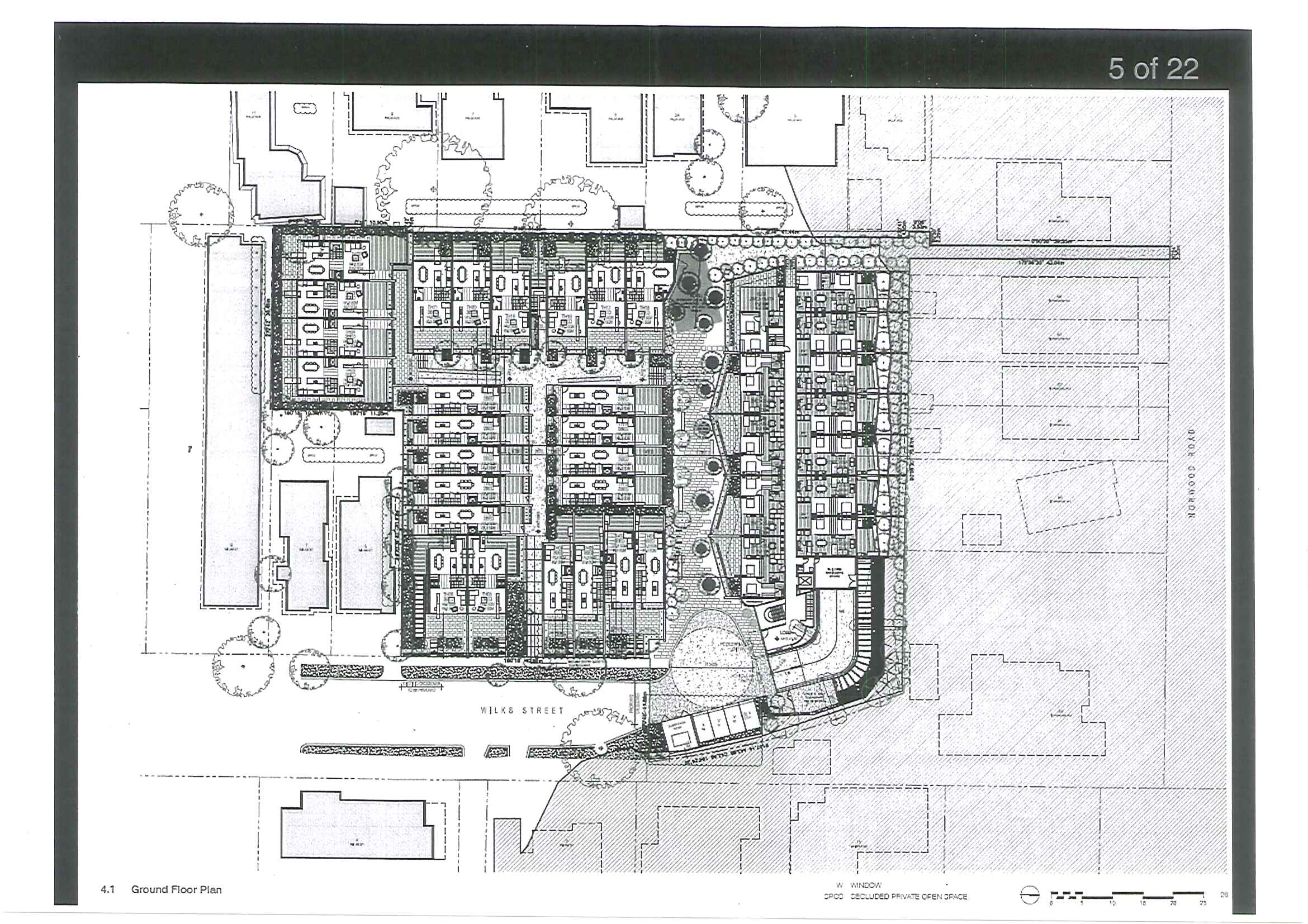
ALMA CLUB APPLICATION

As expected, the officer’s (Ron Torres) report recommends that a permit be issues for “up to 73 dwellings in an apartment style 3 storey building and townhouse style development of 2-3 storeys above basement car parking and a reduction in visitor car parking requirements….”. There were 58 formal objections.

It is worth commenting that this report contains much that is taken verbatim from the developer’s application. As to lighting and internal amenity there does not seem to be any problem in having people live underground – “It is considered the ground floor north facing apartments will have poor solar access as their floor level is substantially lower than the ground level at the northern boundary. Their living room windows are also substantially overhung by the balconies above. Therefore a condition is recommended to setback the first floor balconies to improve the amenity of these dwellings”.

On traffic and its impact on local and adjoining streets we have this: “…the expected traffic generation can be considered in the context of the traffic generated by the Alma Club (when it was operational). Therefore, whilst there will be a noticeable increase in traffic during residential peak times (ie weekday mornings), there will also likely be less traffic at other times when the Alma Club would have generated traffic, such as weekends. Furthermore, Council’s Transport Planning Department is satisfied Wilks Street can accommodate the traffic generated by the development. On balance it is considered an increase in traffic movements within Wilks Street as a result of this development is not unreasonable”.

Not one statistic to support any of the statements! And since when does 5 days of traffic twice a day compare to a declining club membership that is assessed only on weekends? Nor is there any mention of the major arterial roads that run off Wilks St and the safety issues involved. The only change that is advantageous to the community is the recommendation that a 5% open space levy be paid by the developer instead of the 4.75% that had been ‘agreed’ to previously.

All in all another dodgy officer’s report without substance, detail, and a far too heavy reliance on the proposal as submitted by developers. Surely when the community pays their wages it is not too much to expect that officer reports show some initiative and originality plus, providing a substantiated rationale for their decision making that is not authored by the developer.

RECORDS OF ASSEMBLY

First off we note that the online version of agenda has repeated one of the ‘minutes’ – meaning that one document is missing! The trend of secrecy continues unabated however. Notations included in these documents reveal that important issues that will have a major impact on the community HAVE BEEN DISCUSSED but not one word has come out into the public domain concerning these issues. For example:

  • Residential zones – at least 3 times
  • Referendum of Constitutional Recognition of local government
  • MAV state conference – list of motions. Again residents have no idea of council’s position on any of the proposed motions.
  • There’s another couple of interesting items that read – “Cr Hyams – letter to the editor in the Australian Jewish News from a Labor Federal member of Parliament. Need for a Council response to correct the record.” AND – “Cr Hyams – draft letter to the Caulfield Racecourse Reserve Trust relating to members of the public attending and addressing the Trust.” (Please note that Delahunty had raised this issue in a previous meeting); “Cr Hyams – a meeting of the non MRC Trustees of the Caulfield Racecourse Reserve Trust.”
  • GESAC and dispute resolution also gets a nod as well as in the Audit Committee report.

Finally it’s worth mentioning the item recommending the rescission of the Sustainability Policy and enacting a new policy. We have noted several times in the past that the arguments put forward by Hyams and Burke (when it suited them) was that nothing could be done UNLESS IT WAS CONTAINED IN THE MEETING PROCEDURES. There is no facility in the meeting procedures for a rescission of motion! If the argument is to be applied consistently, then this recommendation cannot proceed. But of course in this council we can only expect some glib sleight of hand to justify actions that suit the ultimate objectives!

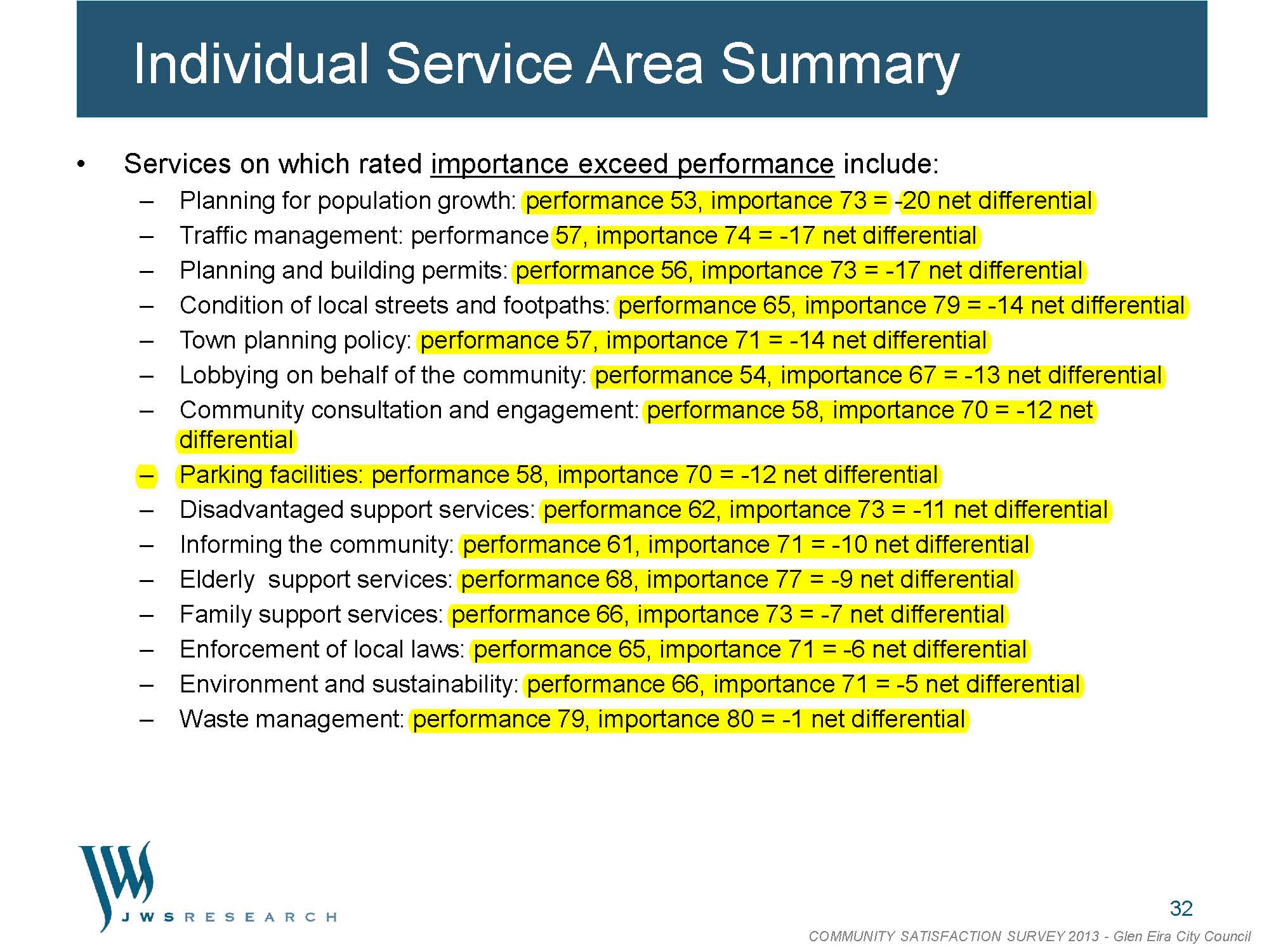
PS: Also along familiar lines there is Newton’s report on the latest Community Satisfaction Survey. The entire report is NOT included in the agenda papers. Rather we’re told that it is available on council’s website. Unfortunately to locate the report will involve a ‘hide and seek’ expedition! The vital aspect of the survey focuses on residents’ expectations as to service performance and their grading of this performance. Below is the relevant information and we point out that once again the huge discrepancy between what residents consider as important and their evaluation of the actual service.

Pages from Community_Satisfaction_Survey_results_2013 PPS: We’ve commented on this previously but given the deceptive reporting of the VCAT decisions it is worth re-iterating. For the 20 Hawthorn Rd application which was overturned by VCAT, council writes:

“Council determined to refuse the application as it failed to satisfy the intent and objectives of the Minimal Change Area Policy, in terms of excessive visual bulk and poor interface with the adjoining residential properties. The development
also failed to satisfy a number of the ResCode standards    ‘.

Not only is this entirely disingenuous, but not does represent what the member actually concluded. In fact, Council itself ‘stuffed up’ big time. It did not even know the areas that were Minimal Change as opposed to Housing Diversity. Here’s what the member concluded:

  1. There is little doubt in my mind that the subject land is in a housing diversity area under local planning policy. As the purpose of local planning policies is to give effect to the municipal strategic statement (MSS),[1] it is relevant to start with the MSS. The MSS includes a Framework Plan the purpose of which is to ‘support and promote’ specific land use outcomes.[2] The Framework Plan, although indicative, includes the subject land as an area along a tram route where ‘multi unit development will be encouraged’.[3] The MSS adopts a targeted approach to meeting future housing needs. It encourages multi-unit housing in identified housing diversity areas. Land along tram routes is a housing diversity area.
  2. The housing diversity area policy confirms the subject land is in a tram routes housing diversity area, having regard to the  Glen Eira  ‘policy framework plan’ and the Caulfield North ‘Framework Plan’.[4] I will return the specifics of the tram routes policy shortly.
  3. That the subject land is in a housing diversity area is confirmed by the minimal change area policy.[5] The policy was recently remade with amendments in Amendment C87 of the scheme (C87). The Council exhibited C87 before deciding this permit application. In the ‘Policy Framework Plan Minimal Change Areas’ map in the scheme when C87 was exhibited and in C87 shows the subject land not in a minimal change area. C87 was approved and commenced on 31 January 2013 and after the Council decided the permit application. It did not change the identification of the subject land as in a minimal change area in that map. In other words, C87 has not changed the identification of the subject land as not being in a minimal change area.
  4. I refer to this history because the Council assessed the permit application as if the relevant policy was the minimal change area policy rather than the housing diversity area policy. This was an error. The Council has now decided that the identification of the subject land as not in a minimal change area for policy purposes was a ‘mapping error within clause 22.08 mistakenly introduced in Amendment C87’,[6] and has prepared Amendment C108 to correct the ‘error’.

The Alma Club application for 75 units raises countless questions about process and the planning scheme itself. Here are a few:

  • Why should developers be allowed to submit CONCEPT PLANS that are vague and wishy-washy? Why should council planners then decide on the basis of such plans? Or could it possibly be that the developer is expecting some major changes that will then become the endorsed plans which will not be in the public domain – especially if these ‘new plans’ come within cooee (30%) of what is currently envisaged? That is, some sweetheart little deals between applicant and council?
  • Even if there is an appeal to VCAT, then there is the problem of amended plans, or council’s position – which will not feature in the public domain and certainly not go before council again. As with the C60, there is a proposal, but no real detail.
  • What also needs to be borne in mind is that if councillors agree to a downsizing on Tuesday night and objectors appeal this decision then the newly announced VCAT fees could be extremely expensive. Again, the developer is in the box seat! Councillors of course will then have their usual scapegoat – VCAT – and they come up smelling like roses instead of addressing the crux of the matter – ie the deficient and suspect planning scheme!

We’ve been forwarded these ‘concept plans’. Below are some extracts taken verbatim from these documents. The comments, conclusions and developerspeak are truly amazing!

The proposed development includes the construction of a medium density residential complex comprising a four storey residential apartment building, 17 two storey townhouses and 8 three storey townhouses with associated parking and landscaping.

The existing site levels provide the ability to achieve higher built form elements in parts of the site without any off-site amenity impacts. Different residential building typologies exist as part of the character of the area, and the introduction of an integrated medium density development would contribute to housing diversity in the area.

With regard to the relocation of the existing telecommunications facility, an indicative new location is shown on the roof of the building.

The subject site is greater than 7,000 sqm, and it is more than three times the 2,000sqm threshold noted above. The proposal also removes an existing non-residential use. For these reasons, it is considered reasonable and appropriate to pursue the type of development being proposed.

More specifically, the proposal will:

  • Deliver a greater diversity of housing;
  • Improve and protect the liveability, neighbourhood character and amenity of the area;
  • Promote environmental and social sustainability;
  • Assist in stimulating the viability of the Alma Village neighbourhood activity centre; and
  • Integrate with the existing neighbourhood

Turning to the provision of private open space, a schedule of areas is provided at Attachement 3. This demonstrates courtyard sizes for the townhouses ranging between 41.5sqm and 136sqm with the average being 61.96sqm. The Schedule to the Residnetial 1 Zone recommends provate open space provisions for dwelling in the Minimal Change Area of 60sqm, and therefore the average provision is considered acceptable.

Today’s Caulfield Leader also featured this article:

Resident ire over plans

Glen Eira residents opposed to development plans for the Alma Sports Club in Caulfield North have formed an association and are raising a war chest to take their fight to VCAT.

They have registered the name Glen Eira Residents Against Inappropriate Development Inc with Consumer Arrairs Victoria, and are looking for moral and financial support.

Committee spokeswoman Vardit Sacks-Davis said the association was formed in response to the Wilks St permit application. The group’s long-term plan beyond that was not yet clear.

“Our aim is to protect, and advocate for, the rights of Glen Eira when threatened by inappropriate development,” she said. Monark Pty Ltd lodged a permit application with Glen Eira council seeking to demolish the historic Alma Sports Club and replace it with a four-storey apartment building with 50 apartments and 25 two and three-storey townhouses. The 7100sq m site is in a minimal change area.

Director Bill Michaelides told the Leader his team had taken a “very balanced approach” but residents maintained it was inappropriate “for many reasons”.

“If this goes to VCAT we intend to fight it there as well so it could be veryk expensive,” Ms Vardit Sacks-Davis said.

Email the group at almaclubobjectors@gmail.com

Hearty congratulations to Kingston City Council on their first public forum regarding the planning zone reforms. About 35 people were present tonight including the Mayor, one other councillor, plus 3 strategic planners and a full time mapping officer. Kingston had obviously gone to great lengths to ensure that information was freely available to residents – ie. the walls were plastered with maps, full colour booklets of 12 pages, and draft amendments including the all important schedules.

The Mayor introduced the evening and his focus throughout the 5 minute talk was that NO DECISION on anything had been made. That Kingston’s intent was to firstly inform their residents of the dramatic planning changes and to seek their input. All questions would be answered and there would be multiple forms of consultation – mailouts, website, council newspapers, advertisements, online discussion forums, etc. Residents had 6 weeks to consider all the information and then council would go away and draft its amendments. Another consultation would then follow before any final decision was made.

The Manager of Strategic Planning then provided a formal presentation with Powerpoint slides. The current Kingston planning scheme was explained as well as what the proposed changes meant for the city. The most striking features of the evening, apart from the genuine desire to inform and consult, were:

  • The extent of detailed local analyses that Kingston had already undertaken. Maps showed each suburb and included a breakdown of every single development – ie single house, 2 units, multi-units etc.
  • The projected population figures and the preferred locations – for example: areas that lacked public transport would be unlikely to be included in ‘growth zones’

The real highlight was the acknowledgement that there was tremendous flexibility available to councils to determine the future of their municipalities. All would depend on the schedules that accompanied each specific zone. In other words, the devil would be in the detail. Councils had the options of:

  • Determining height limits for specific locations
  • Determining setbacks
  • Determining permeability
  • Determining private open space
  • Determining Landscaping
  • Determining site coverage

Structure plans were another tool that assisted in the protection of specific areas.

All in all, the evening was a true eye opener to how different Kingston is to Glen Eira – both in objective and in performance. Unlike Glen Eira, public comment is actively, and we believe, genuinely sought. Further, the extent of the work already done by these officers is literally mind boggling. We can only ask our illustrious lot: why the 9 months of silence and when will they let the public in on what is going on? How much work on population and available lots has been done? Will residents really be informed and consulted, or fobbed off with half-truths and waffle? We wait with bated breath!

Finally, it’s worth mentioning that Kingston claims to have very few of their planning decisions overturned. The reason? Because they have done their homework and ensured that their neighourhoods are holistically planned – in total contrast to the ad hoc and open slather approach of Glen Eira!

permit

The alleged comments by Hyams in this article raise major issues.

  • Why should residents believe him or his script writers?
  • Why is this council doing absolutely nothing in contrast to other councils, much less informing the public in a clear, direct and honest manner about its intentions and the real ramifications of what will happen from July 1st and in the coming year?
  • Is this the most potent example of not merely fiddling whilst Rome is burning, but the clear intention of doing absolutely nothing to review, change or modify a strategic planning approach that is clearly incapable of protecting residents?
  • Could anything be clearer than the refusal to change a damn thing, since according to Hyams, ‘council was happy’ with the residential zones?

Below we feature some extracts from the agenda items for the next Kingston Council Ordinary Meeting. Not only is there a lengthy officer report on the implications of the commercial zone changes from July 1st, but actions to try and ameliorate the potential damage (uploaded here). In Glen Eira all we get is silence, inaction, and misinformation!

With a Planning Permit previously prohibited locations can be used to create multiple Supermarket(s), shop(s) or Department Store(s).

The zoning translation, if not carefully managed at residential abuttals, also has the potential to create adverse amenity impacts with the ability of incompatible land uses to establish without a planning permit.

A Supermarket under 1800m2 or shop under 500m2 associated with or adjoining a Supermarket can be constructed without a Planning Permit. The definition of Shop also includes Bottle Shop. This would mean that beyond issues of policy matters such as loading times, hours of operation or other management issues associated with facilities that may impact on amenity of adjacent residential areas would not be able to be considered.

Businesses of all sizes have made investment decision in the City of Kingston based on the Local Planning Policy Frameowrk and the application of zones. These decisions for numerous business owners have the potential to be immediately and directly undermined through the application of the Commercial 2 Zone in location where certain activities where(sic) previously prohibited.

…it has also been necessary to consider that if the Commercial 2 zone were applied what levels of amenity protection would be provided for immediately adjacent or nearby residential areas when compared with the status quo.

The work of successive council’s (sic) in developing Structure Plans, Local Planning Policies, facilitating retail investment in planned locations and assisting diversifying its employment land will be undermined if the Commercial 2 Zone is introduced to replace the large areas in Kingston zoned Business 3 and 4.

Uses that are permissible under the Commercial 2 Zone such as Supermarket(s), Shop(s) and Department Store(s) that were previously prohibited will impact on small businesses that have invested in planned locations and on community service and infrastructure investment provided in Activity Centres.

The unintended consequence of the introduction of the commercial 2 Zone, is that land uses which Council’s Local Planning Policies clearly discourage in ‘out of centre locations’, become as of right or permissible.

abc

PS: The potential sale of the ABC studios is nothing new. In fact, it has been on the cards for at least ten years. That raises the question of what Council has been doing in the meantime? Is it another instance of too little, too late? The horse has already bolted? Below are some media reports that will interest residents. Please note one real estate agent’s comments regarding the lack of height limits set by council!

The Rippon Lea Estate point of view – http://www.nattrust.com.au/advocacy/campaigns/abc_for_rippon_lea

PLUS

ABC’s Slice of Rippon Lea Estate, Elsternwick, Expected to Sell For More than $25 Million

Written by Marc Pallisco

Monday, 26 October 2009 23:16
 

Rippon Lea

AN 8,000 square metre slice of Elsternwick’s historic Rippon Lea estate, compulsorily acquired by the State Government in the 1950s for the Australian Broadcasting Corporation – is likely to be sold to residential developers, if the ABC vacates the property in 2012.

ABC project director Ray Moore told Secret Agent it is considering selling two Elsternwick properties, currently occupied as studios and offices, including a major complex on Gordon Street abutting Rippon Lea – built on what was once the property’s southern boundary.

Moneys raised from the sales will fund the development of a new $90 million studio at 102 Sturt Street in Southbank, Mr Moore said. The Sturt Street development, which would be next door to an existing ABC office at 120 Southbank Boulevard, is subject to parliamentary approval, but expected to occur.

Sources estimate the value of ABC’s outgoing Gordon Street office to be about $25 million.

They say the land could make way for an apartment complex, similar to that being proposed around the Stonington mansion in Malvern, or a lower density subdivision, as occurred behind Canterbury’s Frognall mansion in the early 1990s.

At close to a hectare, the site could also make way for several apartment towers offering Port Phillip and CBD views, over Rippon Lea’s established gardens.

ABC offices and studios were developed on part of the Rippon Lea estate, prior to the opening of the 1956 Melbourne Olympic Games. Popular television shows including Countdown, The Big Gig and The Late Show were later recorded at what is known as the “Rippon Lea studio”.

The land occupied by the ABC is not on the Victorian Heritage Register, but a Heritage Victoria spokeswoman said the ABC could still return the land to the estate, if it wanted. The imposing Rippon Lea property is managed by the National Trust, and open to the public.

Source: http://www.realestatesource.com.au/abcs-slice-of-rippon-lea-estate-elsternwick-expected-to-sell-for-more-than-25-million.html


PLUS


ABC set to leave home

Phillip Hudson and Nathan Mawby

3 May 2013

Herald-Sun

THE ABC will be leaving its historic TV studios at Ripponlea and the valuable property may be sold for high-rise residential development under plans to build a new headquarters for the national broadcaster in Southbank.

Famous ABC programs such as Countdown were produced at the Gordon St studios, which opened in 1956 with the introduction of television.

In recent years, it has been home to programs such as Adam Hills chat show In Gordon Street Tonight and filming for the series Miss Fisher’s Murder Mysteries.

Under the plan, the ABC will build a five-storey headquarters next to its existing Southbank offices, where its TV news moved in 2001.

It will include new TV studios and a major TV production centre.

The overhaul is aimed at guaranteeing jobs and production in Victoria.

The Federal Government will loan the ABC $90 million, which it has to repay by 2020.

ABC managing director Mark Scott said the new building would be designed to put the ABC’s many services on show.

“All the plans for this area are to make it more visible, more highly trafficked by pedestrians, make it more of a centrepoint of the centre,” he said.

Communications Minister Stephen Conroy said the new building would be home to the ABC’s radio, television and digital production operations as well as its broadcasting and support services.

Senator Conroy said consolidating operations would allow the ABC to achieve operational savings and productivity benefits.

Local architect Robert Mills said the Ripponlea site’s proximity to the CBD, transport, schools and shopping meant that while a feasibility study would be done, it would likely become a residential site.

“It will be controversial, but I predict the final outcome will be a high-rise,” he said.

Mr Mills said that while the building had no council height restrictions, its height would likely be limited by shading.

The former Channel 9 studios in Bendigo St, Richmond, are being transformed into apartments and townhouses, selling for up to $1.2 million.


Another item up for decision on Tuesday night is the residential parking permit scheme. Our take on the proposals are that whilst Rome is burning our glorious council keeps fiddling and fiddling rather than addressing the problem head on as countless other councils have done – some in fact have been at it for over a decade. All Glen Eira seems capable of doing is burying its head in the sand whilst pretending to protect streets in Housing Diversity. But the horse has well and truly bolted so the suggested solution is akin to putting a bandaid on a gaping and suppurating wound. What is required is radical surgery.  Here’s why –

  • Council totally ignores the fact that Minimal Change Areas are being reshaped by 2 and 3 unit developments – ie the ‘problem’ is not just in Housing Diversity
  • Granting permits for car parking waivers only exacerbates the problem everywhere
  • The consistent refusal to introduce well researched and designed Parking Precinct plans or parking overlays (except for student housing) means further adhoc and hence substandard planning.
  • A policy that shunts car parking to ‘neighbouring’ streets is only transferring the issue elsewhere

The Akehurst ‘solution’ is simple – no Residential Parking permits in Housing Diversity (We’ve uploaded the report here).  It does not hold up to close examination and is a tacit admission of council’s spectacular failure to protect amenity and manage the issue. We highlight the following extracts from this ‘report’:

The policy has been applied for 10 years. In this time 457 dwellings have been excluded from obtaining a RPP (Residential Parking Permit).

COMMENT: From 2002 to roughly 2007/8 Council approved 600 dwellings per year. Since then the figure has escalated to approximately 1000 dwellings per year with only about 30% being single dwellings. On such estimates we can argue conservatively that around 5,500 units have been built. To only have 457 dwellings EXCLUDED in a decade is thus a total joke.

Akehurst does briefly note that “some councils deliberately selectively choose to under provide car parking in terms of the ResCode rates” but Glen Eira has always applied the standard ResCode rates related to bedroom numbers and no change to this position is envisaged in this review.

COMMENT: That’s it! A blanket statement with no justification, no facts, no figures, no nothing. Once again, this council washes its hands of anything that involves change and might just threaten the profits of developers. The ‘excuse’ that if change is required then it is considered preferable to link this to new developments  totally ignores that fact that ‘new developments’ are also rampant in Minimal Change! What’s even more damning is that Akehurst himself goes on to define ‘medium density’ as ‘two dwellings or more’!

Councillors and residents have to ask:

  • Why is this policy only applicable to Housing Diversity given that 2 or more dwellings are also mushrooming in Minimal Change and will continue to do so given that the infill in diversity areas is running out?
  • Why the failure to plan strategically, holistically, and appropriately?
  • Why can other councils (listed below) introduce a variety of options and Glen Eira is totally incapable or unwilling?

Moreland – Council issues up to two residential parking permits depending on whether or not there is a driveway crossover to your property.  If you have a crossover, then you are eligible for one permit only. AND Properties are not eligible for parking permits where approval of a planning permit for subdivision was issued after 31 August 2011 and this results in an increase in the number of separate occupancies on that site. (http://www.moreland.vic.gov.au/parking-roads-and-transport/parking-permits-moreland/residential-parking-permits.html)

Bayside –  – 3 permits AND Multi Unit Development Properties are not eligible to participate in the scheme. (http://www.bayside.vic.gov.au/parking_residential_parking_permits.htm)

Port Phillip – One action pursued by the City of Port Phillip since 1997 has been not to issue resident or visitor parking permits to owners or occupiers of properties in instances where the developer / applicant for Planning Permit had not provided sufficient off street (on-site) car parking in accordance with the Planning Scheme or other council policies.  Foreshore Parking Permits are still permitted at No Parking Permit Note properties.

As of the 1 October 2002, this policy was extended to include all new residential developments* where the number of households increased on a property, irrespective of the level of off street parking provided. (http://www.portphillip.vic.gov.au/resident-visitor-foreshore-parking-permits.htm)

Darebin – Each household can have a maximum of two permits. Households with off-street parking (eg driveway), right of way (laneway between house blocks) or with a garage are entitled to one permit only. (http://www.darebin.vic.gov.au/page/Page.aspx?Page_Id=6215)

Monash – single dwelling 2 permits; 2-4 dwellings 1 permit; 5 or more dwellings no permit

Whitehorse – 1 dwelling 3 permits; 2-5 dwellings 1 permit; more than 5 dwellings no permit.

It’s also worth noting that Frankston has a visitor car parking scheme based on the WIDTH OF THE RESIDENTIAL ROAD/STREET. The narrower the street, no parking! (http://www.frankston.vic.gov.au/library/scripts/objectifyMedia.aspx?file=pdf/309/09.pdf&..)

Boroondara – multi unit development prior to 2001 receive one permit. Post 2001 don’t get a permit. (http://www.boroondara.vic.gov.au/~/media/Files/Your%20Council/Parking%20and%20traffic/ResidentialParkingPermitPolicy2011pdf.pdf)

Tonight’s Planning Conference on the Alma Club development revealed in all its sordid glory how rigged the game really is. To their credit however, the developers’ rep did show up and fronted an audience of over 50 people including councillors Delahunty, Hyams, Lobo and Sounness. Magee chaired the conference. Andrew Bromley was the council planner. Even Newton made an appearance for a short time.

Several points need to be highlighted right from the start –

  • The developers and council have agreed that a 4.75% open space levy will be applied. Absolutely amazing when other councils (Bayside, Port Phillip, Moreland and countless others have introduced a MINIMUM of 5% levy across their entire municipalities for a meagre 3 lot subdivision. Here we have 75 units and the blood money is a paltry 4.75%. It would also be interesting to know: who agreed to this? when was it signed on the dotted line?
  • The developers ‘experts’ have verified that 4 visitor car parking spots are ‘adequate’
  • The one bedroom apartments will be exempt from car parking spots!
  • The claim is that the units (in a Minimal Change Area) equate to 42% of site coverage. We are certainly sceptical of this figure judging by the plans!
  • The most vital question however is that given this is in a Minimal Change Area and suggest 4 storey development, then why oh why wasn’t this application rejected right from the start under delegation? The single fact that it is a large site should not over-ride every other single ‘standard’ that is applied to the Minimal Change Area.
  • As a ‘planning conference’ this failed dismally to live up to the published council propaganda – ie ‘Where possible, attempt to resolve or reduce the issues in dispute’. Nothing of the kind happened or was even attempted!

Here is the sequence of events:

Magee claimed that residents were extremely lucky to have these ‘conferences’ because many other councils didn’t do this. Sadly, Magee neglected to mention that other councils have Planning Committees made up of councillors and residents are permitted to address full council on their objections. In Glen Eira objectors do not learn of the planners recommendations until the Friday before the application is set down for council decision and then there is no opportunity to address the council. Magee even had the gall to state that residents should wait for the recommendations and THEN LOBBY THEIR COUNCILLORS!

Bromley started ‘the process’ by explaining the plans. 75 dwellings, 4 storeys. Internal departments had had a look at the application. Objections were basically about: intensity of develolpment, streetscape, parking and traffic, loss of amenity, overlooking/overshadowing, storm water etc. Bromley emphasised that his decision would be mainly looking at the Minimal Change Policy and Neighborhood Character and parking. His report would go to council for decision on the 2nd July.

Objectors then had the opportunity to speak. First speaker said that she represented 22 households and asked for clarification. Said that the Minimal Change policy talked about ‘higher yield’ which doesn’t necessarily mean ‘higher density’ and this term refers to 4 storeys and above.

Asked about the telecommunications pole and the setbacks which weren’t clear from the plans. There was also an issue about an oak tree and wanted to know how this was to be protected. Said there were ‘unclear items’ on the plans. In terms of amenity for surrounding properties, there is a substation kiosk and exhaust right near fences. How many cars each day, etc. Wanted clarification on all these issues. Also wanted to know about the ‘internal amenity’ in the 4 storey apartments because of 4 light courts from the rooftoop to ‘ground level’ as this is the only light source and none will have ventilation. Also asked about drainage and whether this had been ‘factored into the design’. Finally given the layout, how emergency services vehicles were going to have access to the apartments.

MAGEE then said that these were a lot of questions and that the answers would ‘come out in the report’

Next speaker stated that the only large dwellings were basically on Dandenong Rd and a couple along Waiora Rd but they were ‘well set back’. Was also concerned about the body corporate and the decision making when so many owners would be involved and with elevators and other things there would be long term maintenance issues.

Another Waiora Rd residents spoke about a 7 unit development next to her and there were 20 odd cars coming in and out just from this one site. Said it was a ‘complete fiasco’ that that’s been accepted by Council. This application could have over 200 cars and ‘where are they supposed to come out from’? Asked if this was ‘responsible’ for councillors to accept something like this design.

MAGEE then said that it’s the state government who is responsible for setting parking allocations and ‘it’s not something that council can change’.

Another residents said that there were ‘natural springs’ there underground and a while back water came up on Alma Rd. Wanted to know about the water tables on the site and that this site was the centre of the spring, so what measures will be taken to remove the water. And if removed will it come up in someone else’s back yard and what is the process for compensation to residents affected by this? Wanted to know if any of this has been considered and what the strategy is to deal with this. Also wanted ‘assurance’ that the pedestrian right of way would still be open to people. Bemoaned the fact that council didn’t buy the property when it had the chance.

One lady said that she has recently sold her house because she believes that ‘the amenity of the area has been destroyed’ because of all these developments, especially along Dandenong Rd. Said that she lost about $50,000 because of this when she sold. She then took Magee to task stating that the Council had violated  ResCode numerous times and ‘that it is only a guideline not a rule’. Listed several properties that don’t have the car parking that ResCode advises.

Next resident said that anyone who believes that 75 dwellings in a dead end street should have ‘their licence taken away’. Said that plenty of his friends who live in apartments have ‘two or three’ visitor car parks for blocks of 10 units. ‘How 4 car spaces could possibly serve 75′ units ..’is beyond me’.

Another Norwood St resident stated that he had ‘difficulty parking outside my own house’ because of the developments and Norwood has become a rat run through to Dandenong Rd and King David. Said that with what’s happening there are now over 120 new apartments ‘in less than two years’. Said that everything in the area has been ‘altered’ and all to the negative. Said that ‘rates have gone up and property values have gone down’.

One Wilks St resident stated that an application for 2 town houses had been rejected because it was considered ‘high density’ in a minimal change area but ’75 apartments seems to be okay’. Said that in a 16 dwelling street this represents over 400% increase. Said there’s already problems with flooding because of the slope of the land and there have been sandbags in the street.

An Alma Rd resident talked about the traffic which she knows well since she’s lived there since 1986. Said the intersection was dangerous and more traffic is only going to make it worse. Reminded councillors that they’re supposed to represent residents! Caulfield North used to be a ‘blue ribbon’ area and now it’s not. Prices are dropping and thus her children’s futures are affected.

One resident asked that the application not be ‘negotiated’ but ‘flatly rejected’.

The next few speakers all spoke about the traffic and parking and that it’s ‘out of character’ with minimal change. Asked ‘what’s the point of having minimal change’? Reiterated that ResCode is nothing but a guide and an ‘absolute minimum’. Dandenong Rd will have 300% increase in dwellings in the next few years and that ‘will flow on’ into Norwood and Palm Avenue. Said that the area had been flooded 3 times in the last few years and that’s ‘no attention’ in the plan for this. Talked about the tennis pavilion and said that it was considered for heritage listing which never came through and he wonders why. Thought it should be retained in the development.

Next resident asked about the actual construction phase and the congestion, pollution that would occur. Was concerned about the oak tree and the safety issue if it wasn’t protected fully.

One resident highlighted that council approved permits all the time and that if the new unit windows are 9 metres away then that’s okay because these new people ‘are blind’ and ‘can’t see’ anyway! Was disappointed with council for not collecting all the money it could from developers and then open space is further lost to buildings.Asked why this council is going beyond the population figures that the government expects them to meet. Said that the population had increased proportionately more than anywhere else.

One person commented that this would go to VCAT and he doubted that council could stop the development but that they had to ‘draw a line in the sand’ and insist that there be no residents parking permits for this development.

Another resident talked about the tonnes and tonnes of excavation materials that would need to be moved and estimated about 2000 truck movements ‘over four or five months’. Council therefore needs to put ‘a very big bond on the developer’  to ‘rebuild Wilks St’ because it will be ruined. Magee then said that ‘construction plans’ are often ‘put in place’ and that will ‘be part of the process’.

THE DEVELOPER’S REPRESENTATIVE

Said that he wasn’t here ‘to solve’ the issues but that’s it’s all about ‘information’ and him ‘learning from what’s been said’. Said to the first speaker that the architects’ would be happy to sit down with her and explain in ‘more detail’. Said that the planning scheme does acknowledge that it can ‘accommodate’ an area in minimal change if it’s just under 7000 square metres. Said that that’s ‘going to be the real test’ and that’s what ‘officers’ will have to do. Their view is that the proposed density ‘fits’ and that in terms of contemporary planning its becoming less important in the assessment and more about ‘quality of development’. Said it wasn’t an ambit claim and that was put together by consultants.

Said that the telecommunications tower issue is being discussed and will be moved. An arborist looked at the oak tree and they’ll ask that ‘he has another look at that issue’. Said there was no ‘unreasonable overshadowing’; car parking was ‘sufficient’ and that they provide ‘what the planning scheme says we need to provide’ but they are seeking a reduction in visitor car parking. The traffic report says that they’re ‘providing the right nunmber’ but that needs to be ‘tested’. Admitted that there would be ‘additional traffic in Wilks St.’ but they’re not starting from a ‘base line’ where there’s no traffic in Wilks St. There are 100 car parking spots on site and average it out then that will give about 500 extra movements in Wilks St but the street ‘can take that’ according to their traffic advice.

Said that site coverage is 42% because of basement car parking. There is a landscape plan and on drainage they got engineer’s advice. Not a planning issue because there’s no flooding overlay and they are ‘following it up’. If they’re successful and subdivided they will pay 4.75% of land value. Said that insurance, pedestrian right of way still needs to be negotiated with council. On construction there would be a management plan. If successful they were also willing to ‘make streetscape improvements’ in Wilks St.

There was discussion on how the money from the open space levy would be spent and Magee said that would be up to council and not the developer. Also discussion on whether the walkway represents ‘open space’ and the safety given that there had been several attacks in recent years.

When asked if anyone on the team had a concern about the people and ethics the developer’s rep responded that he took advice from experts and was guided by the planning scheme. Said that the traffic engineers have done surveys in comparable developments and they say that 4 spaces are ‘sufficient’.

Magee then summed up saying that on 2nd July the application would be decided but people can’t speak. Their opportunity will come on the 28th when the agenda goes up with the officer’s recommendations. ‘You then have the opportunity to contact the 9 councillors….you’ve got Friday, Saturday, Sunday, Monday, Tuesday’. Councillors can accept the officers’ recommendations or reject, modify them. Applicants or objectors can then go to VCAT.

One resident asked that the meeting be adjourned and that people who couldn’t be present come along for another meeting. Magee declared the meeting closed.


PS: we thought it would be informative if we uploaded one of the pages for the plans. Please note:

  • the ‘gated city’ effect so that emergency vehicles have literally no access.
  • the lack of sufficient open space

130606 Plan 5 of 22 Ground Flr of 1 Wilks Street

On  4th September 2012 Council passed a resolution to refuse an application for a 3 storey, 11 unit development in Cromwell St, North Caulfield. Officers had recommended the go ahead arguing the usual – housing diversity, near a tram line and commercial centre, etc. On the same night, there was another application for a 4 storey development in Howitt Road. Lipshutz and Esakoff sought to reduce this second application to 3 storeys. It abutted a Minimal Change Area. In the end the 4 storey motion got through. Whilst it could be argued that we are comparing apples and oranges, it’s perhaps worthy of noting that the Cromwell St application (for 3 storeys) was rejected. We also ask, how many other 3 storey applications have got the gong from these councillors in the recent past? There was also this declaration –

Cr Lipshutz declared a conflict of interest in this item pursuant to Section 78E of the Local Government Act being an indirect interest by reason of his mother being an objector to the application.
8.19PM Cr Lipshutz left the Chamber.

The Cromwell St. saga now features in today’s Leader.

cromwell

There’s the opportunity in all council planning schemes to include a ‘Monitoring’ and/or ‘Review’ section. Most councils use this to establish their objectives and the criteria against which the ‘success’ of their policies will be evaluated. Many include such elements as: drainage, open space, social and environmental amenity, transport options, etc. In Glen Eira, these terms barely get a look in! All in all, the Monitoring and Review pages of the Glen Eira Planning Scheme are nothing but empty pledges and more public relations propaganda. We ask readers to examine the following and to make up their own minds as to the real value of the criteria themselves and how well council has performed even against these lamentable standards.

21_mss14_glen_Page_121_mss14_glen_Page_2

How many more stuff-ups should the community pay for before heads start to roll? What excuses will this planning department come up with this time? Another ‘clerical error’? Another ‘slight oversight’? Each stuff up costs money, staff time, and of course, embarrassment and an insight into plain old incompetence. In this instance, the VCAT member himself has laid all bare. When officers delegated with the responsibility of making decisions based on their own planning scheme don’t seem to know what the planning scheme contains, then one has to question what is going on. We present some of the extracts from the latest schemozzle. For the full decision, see: http://www.austlii.edu.au/au/cases/vic/VCAT/2013/770.html. The application is for 20 Hawthorn Rd, North Caulfield and involved a 3 storey and nineteen dwellings (eleven one-bedroom and eight two-bedroom).

There is uncertainty about whether the subject land is located in a housing diversity area or a minimal change area under local planning policy.

There is little doubt in my mind that the subject land is in a housing diversity area under local planning policy. As the purpose of local planning policies is to give effect to the municipal strategic statement (MSS), it is relevant to start with the MSS. The MSS includes a Framework Plan the purpose of which is to ‘support and promote’ specific land use outcomes. The Framework Plan, although indicative, includes the subject land as an area along a tram route where ‘multi unit development will be encouraged’. The MSS adopts a targeted approach to meeting future housing needs. It encourages multi-unit housing in identified housing diversity areas. Land along tram routes is a housing diversity area.

The housing diversity area policy confirms the subject land is in a tram routes housing diversity area, having regard to the Glen Eira ‘policy framework plan’ and the Caulfield North ‘Framework Plan’. I will return the specifics of the tram routes policy shortly.

That the subject land is in a housing diversity area is confirmed by the minimal change area policy. The policy was recently remade with amendments in Amendment C87 of the scheme (C87). The Council exhibited C87 before deciding this permit application. In the ‘Policy Framework Plan Minimal Change Areas’ map in the scheme when C87 was exhibited and in C87 shows the subject land not in a minimal change area. C87 was approved and commenced on 31 January 2013 and after the Council decided the permit application. It did not change the identification of the subject land as in a minimal change area in that map. In other words, C87 has not changed the identification of the subject land as not being in a minimal change area.

I refer to this history because the Council assessed the permit application as if the relevant policy was the minimal change area policy rather than the housing diversity area policy. This was an error. The Council has now decided that the identification of the subject land as not in a minimal change area for policy purposes was a ‘mapping error within clause 22.08 mistakenly introduced in Amendment C87’, and has prepared Amendment C108 to correct the ‘error’.

I must apply the scheme in its current terms. The subject land is not in a minimal change area for the purposes of the local planning policy framework. The Council has prepared an amendment to include it in such an area but no notice of the amendment has yet been given, so it may be well away from being adopted and being a serious entertained planning proposal or being approved. I therefore give Amendment C108 little weight.

The schedule to the R1Z is now potentially inconsistent with the local planning policy framework. The schedule sets modified standards for site coverage, rear setbacks and private open space for land in ‘a minimum change area … as shown on the map forming part of this schedule’. The map attached to the schedule shows the subject land in a minimal change area.

How should the scheme be read to resolve this potential inconsistency? In my view, even though the subject land is not in a minimal change area for policy purposes but is in a minimal change area under the schedule, the scheme needs to be read to as if there are two minimal change areas for separate purposes. The separate and distinct nature of the two areas is reinforced when it is understood the drafters of the scheme could have applied the different standards for a ‘minimal change area as specified in clause 22.08’ in the schedule. That would have been clearer. But the drafters did not do this. They decided to refer to a minimal change area as defined by map included in the schedule. It may be unfortunate and confusing that both are identified as a minimal change area and the relevant maps are very similar in overall appearance but the potential inconsistency must be resolved by giving the two minimal change areas an independent effect

Building site coverage is complex for this proposal. Mr Bastone’s (for developer) estimate is 53%. Mr O’Leary’s (for Council) estimate is that, although the basement covers about 75% of the site, it is over 60% because part of the ground floor is above the ground towards the rear of the subject land. Mr O’Leary unnecessarily and inaccurately included ground level covered by projecting balconies in his calculation. For the purposes of assessment, I would accept that the coverage is around 60%. The schedule to the R1Z provides a standard that coverage not exceed 50%. It applies to land in a minimal change area shown on the map in the schedule. In a housing diversity area, the standard is 60%.

In my Mr Fairlie’s opinion, one basement visitor space is impractical but I prefer the submissions of Mr O’Leary that with sufficient organisation between residents and their visitors, one space would be of assistance. The owners corporation will need to make rules about use of the space.

« Previous PageNext Page »