GE Planning


We’ve received the following email that was sent to all councillors. It is also worth pointing out that less than half of these ‘representatives’ responded to the email. To emphasise what is happening and the shambles that is the current planning scheme, VCAT has just granted a permit for 4 storeys and 39 units at the corner of Jersey Parade/Elliott Avenue, Carnegie.

Here is the email –

“It seems that the final death blow to Claire St is about to be dealt, with the application for a permit for a huge development covering 5 of the 6 blocks on the western side of Claire St. The scale of this proposed development is totally out of all proportion to the street, and is a perfect reflection of the total failure of Glen Eira’s Planning Scheme. We are sure that even the most diehard supporters of this scheme are now realising what a disaster it has become; a free-for-all where the developers are falling over themselves to get in and create the most cost effective yet least attractive, environmentally insensitive and unsustainable housing possible, with the inherent destruction of all existing vegetation.  We would like to think that none of the councillors in their wildest dreams ever envisaged that this is what would become of the planning scheme – development so rapacious and insatiable that it is ripping the heart out of what was once an attractive, charming and very liveable suburb. It seems to us that in recent months the councillors have finally seen this for the total disaster that it is and are starting to reject some of the most inappropriate development proposals such as 6-10 Claire St. However, this gives us very little comfort, as we know that the developer will proceed straight to VCAT, which, operating within the parameters of Glen Eira’s own planning scheme, must still approve these developments as they comply with the requirements for this zone.

Our only hope now is that the upcoming review of the planning scheme will recognise how wrong Glen Eira got it and will make some serious changes to what can be allowed in a GRZ. This is the only way to allow both Council and VCAT to have some control over what is built in these areas. Can you please give us a commitment that you will agree to making major changes to the planning scheme to help protect  our residential areas from this tsunami of inappropriate development. It is OK for councillors to admit they got it wrong and try to do something about it; we sense a huge groundswell of anger from local residents who are now seeing what is happening all around them, and know that any councillor still trying to cling to this disastrous policy will face electoral oblivion at the upcoming council elections.

Yours sincerely,

XXXXXXX”

PS: We now learn that Council is to receive the pittance of $575,000 as the open space levy for Precinct One of the Caulfield Village development (ie 463 units). In their wisdom only a 4% fee was exacted for this part of the development.

Item 9.2 – Riddell Parade, Elsternwick. Application for 12 storeys and 40 dwellings.

Whilst the officer’s report recommends a ‘refusal’ there are several fascinating aspects to this application.

  • Council in its wisdom decided last year to sell the owner of the site a 60 sqm splay from its council owned car park that is also the corner edge of a laneway. This was done in order to “allow them to build a first floor above and a basement below the splay but still allow sightlines along the adjacent laneway.” (Minutes of May 19th, 2015). In return, council received the princely sum of $59,015 and the developer was to pay legal costs of $26,222.
  • The proposed development is deemed as Stage 2 since Stage 1 is for an 8 storey development (under construction) and both sites belong to the same owner.
  • Only 14 properties were notified and 3 objections received.

All the above is merely the ‘background’ to some extraordinary aspects of Rocky Camera’s report. The question is: does this report represent some ‘radical’ change in council’s approach or is it merely Camera once again scraping the bottom of the barrel in order to come up with any justification for a refusal?

For the first time, as far as we know, we have statements such as:

…..the development fails to adequately encourage economic development. A building of this height, scale and location should provide for more economic development opportunities than one ground floor office space.

No communal facilities are proposed within either the approved development (Stage 1- 28 Riddle (sic) Parade) or within the proposed development. This is considered to be a poor outcome for a development of this scale.

A total of 58 car spaces are provided on-site. A reduction in the residential visitor and office car spaces is sought. However, the allocation of car spaces is unclear due to the oversupply of residential car spaces. Further, no disabled car space has been provided.

The application proposes vehicle access through ‘Stage 1’ of the development at 28 Riddell Parade. However, there is no formal legal accessway provided between both properties currently.

These are literally extraordinary ‘reasons’ for refusal – especially when seen in light of previous decisions. For example:

  • In November 2012 the officer report for 1056 Dandenong Road recommended ‘approval’ for a 12 storey and 173 dwellings. Councillors knocked this back to 8 storeys and 97 dwellings. The developer got what he wanted at VCAT. However, there was not a single word in this report on ‘communal facilities’. Nor do we find any mention of this in the recent 9 storey application in Centre Road, Bentleigh – nor in countless others!
  • The current Camera report also just happens to conveniently ignore other sections of the Planning Scheme that were included in the 12 storey application. Omitted here are – To consolidate retail functions within existing strip shopping centres; To encourage increased densities within and around commercial/transport nodes which respect transition to the surrounding residential area; To ensure future development is appropriate to the constraints of infrastructure and vehicular traffic movement (including parking). We must also remember that the site is within the Elsternwick Urban Village, where everything in the planning scheme promotes higher density.
  • If there is an ‘oversupply of residential car spaces’, then why not simply turn these ‘residential’ spots into ‘visitor’ car parking spots as done in countless other application conditions?
  • If the developer owns both sites, then is ‘formal legal accessway’ nothing more than a furphy? It will be interesting to see how VCAT views the issue.
  • Surely the argument regarding ‘employment’ and ‘economic development’ is on very shakey ground considering that the rationale has always been that increased populations in urban villages via higher density dwelling, will ‘invigorate’ centres and help sustain them?

Thus we are again faced with the conundrum of a planning scheme that facilitates high rise development and planners engaged in major ‘damage control’ forced to come up with ‘reasons’ for refusal that anyone can drive a truck through – especially developers with stacks of money for ‘expert witnesses’ and reports! Residents are now paying the full price of a planning scheme that administrators and councillors have refused to touch since 2002. As we’ve stated previously, the only valid response is a total revamp of the zones and a major overhaul of the planning scheme.

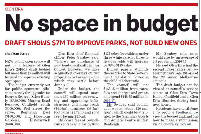
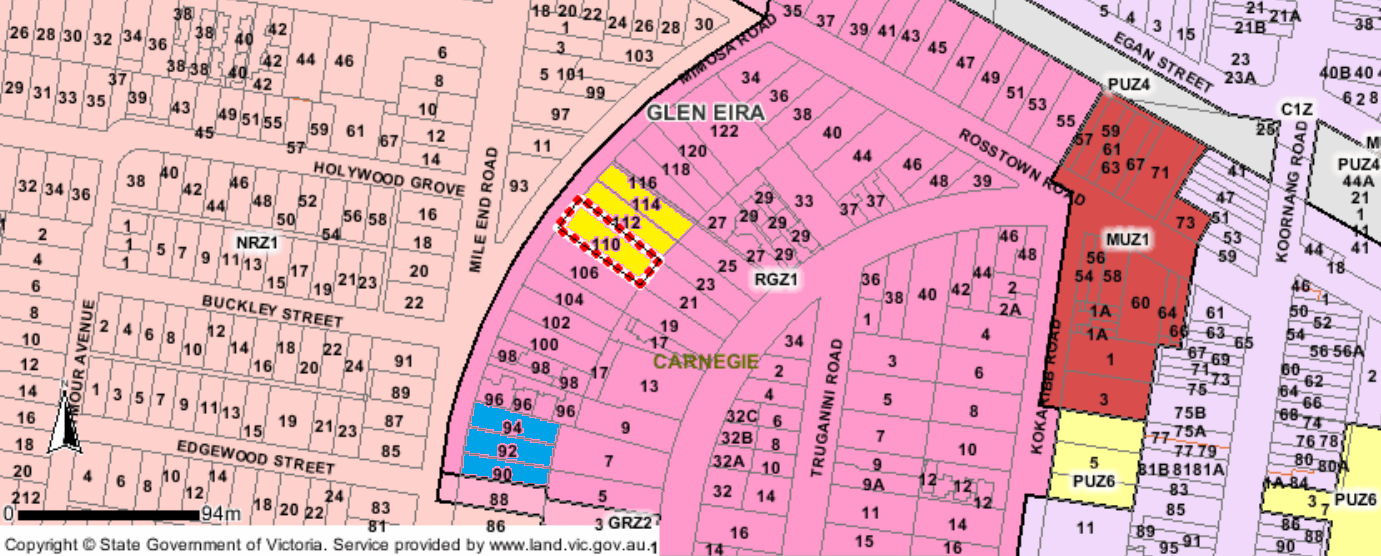
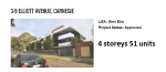
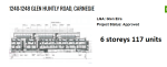
God help us if this is the quality of planning application reports by officers! We are referring to an application for 4 storeys and 49 units at 90-94 Mimosa Road, Carnegie. The area is zoned Residential Growth Zone, and a permit has already been granted by VCAT for 4 storeys and 50 units at 110-114 Mimosa Road – just a few doors down the same road. Of course, this is not even mentioned in the Camera report!

Untitled

The recommendation is to refuse the permit. We wonder whether the correlation between refusals and the number of objections has again reared its ugly head (ie 56 objections). Please note, we are not disagreeing with the recommendation to refuse, but are merely pointing out how Rocky Camera is literally scraping the bottom of the barrel to come up with any valid reason to refuse the permit given council’s current planning scheme. In our opinion, the officer’s report is not only sub-standard, but hasn’t got a hope in hell of convincing VCAT.

Then of course, there is the argument that if council didn’t want ‘consolidation’ of lots, or 4 storey developments along Mimosa Road, then why did they zone this as a Residential Growth Zone? Trying to put the genie back in the bottle now, is far too late. If instead of simply drawing a circle on a map, council had done its work properly at the time of introducing the zones, we wouldn’t be having the farce that is now standard practice for council. Nor would we be having to cough up tens of thousands of dollars for officers and consultants to go to VCAT on wild goose chases and at ratepayers’ expense. This is literally money thrown down the drain.

Here’s why:

Camera writes – Policy encourages that the highest residential densities be located in Urban Villages, particularly for sites in closest proximity to a commercial activity Centre. The case is different here noting the subject site is located on the outer edge of the Residential Growth Zone with lower intensity zones located to the south and west.

COMMENT: decision after VCAT decision has already commented on the fact that proximity to the centre of an urban village is not an argument, and that if anything it is the GRZ2 zones which are to be taken as the ‘transition buffers’.

This illustrates that the subject site in a more sensitive ‘transitional’ location on the ‘fringe’ of the Residential Growth Zone, with lower density residential zones to the south and west.

COMMENT: When VCAT considers that a 2 storey differential is not enough to refuse a permit, then the difference between RGZ (4 storeys) and GRZ (3 storeys) will not carry any weight whatsoever. Readers should also remember how many developments that directly abutt Neighbourhood Residential zones (ie 2 storeys) have been granted permits by council alone.

Whilst policy also supports a degree of change in this area, the proposal is not site responsive nor is it contextually appropriate having regard to the disparity in scale and massing between the 4 storey building and prevailing single storey development pattern on the west side of Mimosa Road (and beyond).

COMMENT – Again a totally ludicrous argument when back yards in countless streets are the ‘buffer’ between RGZ and the other zones. Or, streets become the buffers between the various zones – ie one side of Garden Avenue Glen Huntly is zoned for 3 storeys (GRZ1) and the opposite side is 2 storeys (NRZ). One section of Balaclava Road is also zoned RGZ and across the road it is NRZ. The same applies for Kambrook Road and Newington Road; Blackwood St in Carnegie as well – or Rowan Street in Elsternwick. There are countless examples of this throughout the municipality. Does this mean that Camera’s argument applies to all? Or is it only that the decision has been made to refuse this application and something has to be coughed up in the attempt to justify the pre-determined decision?

The building will be highly prominent and further exacerbated when viewed at street level and from the wider area due to the site’s overall area (as a result of the consolidation of three lots). As such the development will unreasonably detract from the character and residential amenity of this transitional location (between zones).

COMMENT: All of a sudden ‘residential amenity’ is a concern, when the schedules to the zones do not provide any consideration of ‘amenity’ in the RGZ areas. And doesn’t the planning scheme after all actively ‘encourage’ the consolidation of lots?

Whilst redevelopment of the site at a higher density (than what currently exists) is not opposed, it is considered the proposal fails to adequately respect the neighbourhood character due to excessive mass, bulk and scale of the building (thereby resulting in unreasonable visual bulk impacts to the streetscape and adjoining properties).

COMMENT: how can one speak of ‘neighbourhood character’ when ‘change’ is the purpose and there is no ‘preferred character statement’ whatsoever in the planning scheme for housing diversity. As pointed out numerous times in VCAT decisions.

The development has a Planning Scheme car parking requirement of 62 car spaces (53 resident spaces and 9 visitor spaces). A total of 58 car spaces are proposed on-site (53 allocated to the residential dwellings and 5 to the visitors). This results in a shortfall of 4 visitor spaces. Council’s Transport Planning Department does not oppose the proposed shortfall of 4 visitor car spaces for the development

COMMENT: and the final insult to injury is that council itself does not insist on the requisite number of visitor car parking spaces.

The flood gates have now opened on Mimosa Road – as they have in every street that is zoned RGZ and GRZ. Council can continue to blame VCAT but in our view the fault basically lies with a planning scheme and a planning department that has failed dismally to undertake proper strategic planning. What residents are now faced with is council’s ‘damage control’ tactics. It is very, very easy to refuse application after application and continue to blame VCAT. As for the quality of the Camera report – in our view it is not only sub-standard, but not worth the paper it is written on. There is not one single ‘fact’ – ie what is the percentage of overshadowing? what is site coverage? Compared to the depth and comprehensiveness of other council’s reports on planning applications, Glen Eira should literally hang its head in shame!

A comment went up on our last post which we believe needs to be highlighted:

We live in the house next to the 51 units, 4 storeys, 3-9 Elliott Ave. It is on our north side! We will also be opposite 60 more units in Elliott Ave. Only 6 out of 20 houses left in our part of this small suburban street…… what can we say. We explored all avenues including going to VCAT, employing a Planner for quite a substantial fee. We achieved some minor concessions with shadowing and setbacks. It has been an exhausting process. I wonder if we are completely stupid to continue to stay here after 36 years, enjoying the peace and convenience of living in Carnegie. However, all has changed. The council has won. The peace and joy of living here is shattered. We will stay and see how things pan out. The world is changing at such a rapid pace around us and I’m afraid we’ve lost faith in the Council and it’s concern for the community. We will look back in a few years time at the implementation of these zones and wonder how it could happen. In a bizarre way it makes me empathise with the first people of our country and the bewilderment of colonisation! Rapid change can leave a community depleted.

The comment is not from a NIMBY, or someone simply bemoaning the pace of change. What this comment expresses is:

  • the utter devastation that the zones have caused to neighbourhoods and to individuals
  • the failure of council administration and councillors to provide planning outcomes that are justifiable
  • It illustrates completely how incompetent and negligent the imposition of the zones are when they fail to even meet Matthew Guy’s parameters

We have commented numerous times on Elliott Avenue, Carnegie and shown the once beautiful, well kept Edwardian cottages that are now gone. (https://gleneira.wordpress.com/2015/02/09/one-little-local-street/) Elliott Avenue is only one street. The same is happening to countless other streets and entire neighbourhoods. Why? Because the zones and the planning scheme encourage such destruction when there was no need for it. Even in their secret meetings, Newton and Hyams promised Matthew Guy that there would be 80+ years of available development sites! Glen Eira has now quadrupled the number of new dwellings it needs to meet population growth. Yet nothing has been done to ameliorate the damage and to amend the zones so that residential amenity is given greater protection. This failure must be sheeted home to all councillors and planners.

Here are the facts:

  • Guy proclaimed that Residential Growth Zones (which this section of Elliott Avenue is zoned as) should be ‘Medium Density Housing’ and that the zones should be in ‘appropriate locations near activity areas, train stations, and other areas suitable for increased housing activity’. The current papers accompanying the review of the residential zones (MRDAC –advisory committee) define ‘Medium Density Housing’ as LESS THAN 75 DWELLINGS PER HECTARE. The section of Elliott Avenue zoned RGZ, is now approaching 220 dwellings per hectare!!!!!!! This kind of density belongs in selected commercial areas and never in a quiet residential street!

Untitled

  • Council’s definition of planning is to simply place a compass point at a train station (ie as in Bentleigh and Carnegie) and then draw a circle with a circumference of roughly 400 metres. This then becomes the ‘activity centre’ and determines the RGZ zoning. The map above shows how insane this is when walking distance to the train station from Elliott Avenue is well and truly greater than 800 metres. Plan Melbourne Refresh insists on activity centres concentrating on ‘walkability’. To therefore determine that just because a train station is (as the crow flies) about 400 metres away that this street should therefore be RGZ, is planning at its most incompetent and lazy. But that is what this council has done time and time again.

Residents, especially those residing in activity centres (including ‘neighbourhood centres’) must insist that the current planning scheme and its woeful local policies be consigned to the rubbish bin and that amendments are introduced asap which seek to halt the destruction of streets such as Elliott Avenue. Anything less is unacceptable.

We reiterate and urge all attendees at the ‘forums’ to proclaim loudly and clearly the need for:

  1. structure plans
  2. height limits for commercial and mixed use zoning everywhere
  3. parking precinct plans
  4. Urban design frameworks and Design & Development Overlays (DDO) that include more than simply regulating fence heights as is currently the case in 3 out of the 5 DDO’s in Glen Eira
  5. Infrastructure levies on developers for drainage (removed in 2010)
  6. For every car parking waiver a levy of at least $10,000 per waiver
  7. Tree protection (on private land)
  8. Heritage review of entire municipality and that this has some ‘bite’
  9. And most importantly, amending the schedules to the zones, and the zones themselves!

Our thanks to Urban Melbourne for these pics!

IMG_0001IMG

We continue our ‘series’ which we started in February on councillor decision making on applications and the results at VCAT. Now that there is finally a planning scheme review being undertaken, council must address the core issues of what is missing in council’s planning scheme.

In our February post (https://gleneira.wordpress.com/2016/02/17/dumb-or-complicit-1/) we asserted that councillors have not learnt from their mistakes; that they have been content to play to the gallery and repeatedly knock off a level or two, or the number of apartments, and think they have done their job. History shows that in every single decision involving a reduction in height or dwellings and where the developer has subsequently gone to VCAT such councillor decisions have been well and truly trounced.

When decision after VCAT decision spells out in lurid technicolor what is amiss with the planning scheme and nothing has been done to address these gaping holes, then as we stated in our header – either councillors are incredibly dumb or completely complicit in a pro-development agenda!

With elections around the corner, readers need to take careful note of who voted for what!

COUNCILLOR DECISION – #5 – 8 Railway Crescent, Bentleigh. Application was for 3 storeys and 10 apartments. Officer recommendation – permit granted. Esakoff and Lipshutz moved motion for 3 storeys and 8 units. Motion was carried unanimously. Developer went to VCAT and was awarded his 10 units. Member decision included: I could perhaps understand Council seeking to remove Dwellings 9 and 10 if there were direct and unacceptable amenity impacts, such as overshadowing of neighbouring properties, or if the site was on the boundary with land included in a Minimal Change Area and in the Neighbourhood Residential Zone.  But neither of those circumstances applies here. The land is well away from the boundary of a Minimal Change Area and the only adjoining property affected by overshadowing is to the east and any shadow is only cast in the mid afternoon to the non-secluded front yard. I note that Mr Wood, Mr O’Brien and Mr Filatov do not live adjacent to the site and are not directly affected by the two dwellings proposed to be deleted. Ms Snell agreed that the development complies with all the numeric ResCode standards

COUNCILLOR DECISION -#6 – 24-26 Mavho Street Bentleigh. Application was for 4 storeys and 28 dwellings. Officer recommendation to grant a permit. Hyams and Lobo moved motion to grant permit for 3 storey and 25 units. This motion was carried with Pilling voting against it. Developer went to VCAT and got his 4 storeys and 28 units! The decision reads in part – I am not persuaded by Council’s zoning submissions that the surrounding zoning will in some way perform the role of limiting development or height in this case on this site. This site is clearly in the Residential Growth Zone and does not share a boundary with any other zone….I am not persuaded that this site is to perform a transition role. The is a zone and an area of intensive development. Other sites further will peform this transition role. The fact that Council has rezoned 24 Mavho Street Residential Growth as is the adjoining lot at 22A and 22B Mavho Street and then the zone changes to a General Residential Zone at 20 Mavho Street, tells me that the transition site and role is performed at 20 Mavho Street.

In what can only be seen as a total admission of failure (and straight out incompetent planning) Hyams and Delahunty moved this Request for a Report at last Tuesday night’s council meeting –

Crs Hyams/Delahunty

That a report be prepared on whether Council should apply for a planning scheme amendment to raise the Public Open Space Contribution Levy above the current 5.7%.

Thus, just on one year since the amendment was gazetted, council is now acknowledging that 5.7% falls far short of what is required. The ‘excuses’ provided were that Council’s ‘assumptions’ and conditions have changed. Nothing could be further from the truth! The so called building boom owes much to the introduction of the new zones which date from August 2013 – 2 years before the open space amendment was gazetted and a year after the deficient open space strategy was made public. The writing was literally on the wall and council needed to introduce a far higher open space levy to ensure that funds were available – but more importantly that the amount of public open space per individual did not decline.

Nor does this sudden interest in open space account for 11 years of doing absolutely nothing to raise funds to purchase open space. The levy from 2004 to 20015 was not only miniscule, but a gift to developers. Exacerbating the situation was the failure of council to purchase additional space apart from 2 house blocks in Packer Park even though the lack of public open space in Glen Eira was known and stated in both the 1987 and 1998 open space strategies.

What is even more disgraceful is the repeated and continuing slurs (including last Tuesday night) cast on the 2 objectors to this open space amendment and the completely bogus claim that their objections cost council in the vicinity of $1 million. How much did council cost ratepayers from 2004 to 2015 with its laughable levy rate? And how dare the likes of Hyams and Lipshutz in particular cast slurs on residents who decided to exercise their legal rights and object to council’s inadequate proposals and shonky strategic planning?

It is now obvious that 2 residents were able to forecast  what would happen a lot better than ‘consultants’ who cost $130,000 and councillors who were determined not to listen and bureaucrats who were only intent on limiting the damage for developers.

FYI, here is part of one of the submissions presented to the Planning Panel that argues strongly that a 5.7% levy is inadequate – especially since Stonnington with the second least amount of public open space opted for an 8% levy. In the end Stonnington achieved its 8% levy for 4 major suburbs – South Yarra, Windsor, Prahran and Armadale. The total area of these 4 suburbs at 8% will alone bring in more than Glen Eira’s 5.7% across the entire municipality. Further, Stonnington’s objective is to keep creating further open space with its $36 million in the kitty as opposed to Glen Eira’s splurging on mega palaces and concrete and disowning its twice passed resolution that the levy would go for the purchase of open space and not the ‘maintenance’ of existing open space!

“NEED FOR AN INCREASED LEVY

Contention: The proposed contribution levy of 5.7% is inadequate to meet the open space needs of the existing and future populations of Glen Eira.

Throughout this submission I have pointed out that:

  • The projected population figures are extremely conservative
  • The cited potential land development area is well and truly underestimated
  • The rate of development in Glen Eira has risen astronomically
  • The stated land values are well below the current market figures
  • Infill development figures and how they impact on potential revenue is ignored
  • Impact of strategic development sites is ignored

As a consequence of all the above, a 5.7% levy, and the overall recommendation to create (at a maximum) another 11 or so hectares of public open space will not meet the needs of the community. I acknowledge fully that there is no standardised methodology for determining what an appropriate contribution levy could be. I also acknowledge that the consultants were to a great extent dependent on figures provided to them by council. It is precisely these figures which I believe are suspect and need to be fully reviewed and updated.

Without access to current council data I can only hypothesize on what would be an appropriate levy given all the above factors. What I do find telling however is the comparison with the current Stonnington proposed contributions levy and the analysis done by their consultants. As pointed out in an earlier table, Stonnington is two-thirds the size of Glen Eira, has a smaller population, and has the second lowest amount of public open space in the state, behind Glen Eira’s record of having the least amount of public open space. Yet Stonnington’s consultants find that:

Based on current provision of open space throughout the City, the Strategy identifies that acquisition of 53 hectares is required to meet the benchmark. When factoring in population growth acquisition of 108 hectares would be required to meet the benchmark[1]

The Glen Eira OSS provides no quantifiable benchmark to work towards. If no targets are set, then I’d argue that it is extremely difficult to calculate what revenue is required in order to meet the most minimalist standards of open space per individual – especially if the data is highly suspect. At a maximum, the OSS recommends the acquisition of another 11 hectares of open space in the entire municipality.  The  least recommended would only equal another 2.2 hectares, and the ‘average’ is given as 6.51 hectares. None of these possibilities are adequate. If Stonnington is currently finding a deficit of 53 hectares then Glen Eira’s claims to need only an additional 11 hectares at best, does indeed appear well below the mark.

There’s also Stonnington’s request that their contribution levy be raised to 8%. Why a council with the second least amount of public open space should ask for an 8% levy, and the council with the least amount of public open space only demands 5.7% levy is quite frankly, beyond me.

Nor do the consultant’s reports provide any historical breakdown of levy contributions per precinct as does Stonnington. All that is cited are the cumulative figures for each financial year. Without such a breakdown it is incredibly difficult to gauge where the majority of subdivisions are occurring; the nature, scope, and size of these subdivisions and how these may indicate what occurs in the future – especially in the urban growth centres.

Stonnington has also created a list of proposed projects for its entire 20 year plan and its figures are based on the anticipated costs. Apart from disclosing 3 projects in the current budget, Glen Eira has not revealed whether in fact it even has such a long term plan and what the specific projects might entail and hence their probable costs. Again, a highly dubious basis upon which to calculate what needs to be done over the next 13 years.”

AND THE CONCLUSION

“Based on all the above I would strongly urge the Panel to recommend a higher contributions levy than what is currently proposed. I am not able to provide a definite figure since I have no access to the current data and I do not consider it my task to do so. That belongs to council and the consultants.

If the residents of Glen Eira are to be well served via the acquisition of the necessary public open space, then I urge the panel to recommend a total review of what has been proposed and that this is based on the most up-to-date and accurate data. Glen Eira residents cannot afford to undergo any further loss of open space which is inevitable I believe, if the current proposed amendment remains unchanged.”

[1] SGA Economics & Planning. (2013). Assessment of Mandatory Open Space Contributions – Page 16

Here are some more developments taking place in our municipality. Whilst councillors have sat on their hands doing bugger all about an inept planning scheme and blaming VCAT for all their ills, developers have been having a field day. This is the inevitable result – 5 developments alone providing what the planning scheme says is the ‘average’ number of new dwellings per year! Please also note that some of these are not even in what is euphemistically called our ‘Urban Villages’ (Bentleigh, Elsternwick, Carnegie) but in the now defunct Neighbourhood Centres, which are supposed to have only ‘medium density development’.

If this is not the Glen Eira you want, then make your views heard at the current Planning Scheme Review. Insist on real change and a real commitment to protecting residential amenity. Do not be satisfied with a mere tinkering of the current scheme that in the end achieves very little.

We have already outlined what residents at the first forum thought should be done. We repeat some of these:

  • structure plans
  • parking precinct plans
  • developer levies on car parking waivers and on drainage
  • stringent review of the zones and the schedules
  • tree protection and greater emphasis on environmental sustainability
  • full and comprehensive heritage review

1

2

3

4

5

Why is it that Glen Eira is so out of kilter with every other council, especially when it comes to providing information to residents on vital issues, or even providing decent, informative answers to public questions.

On Tuesday night, several questions were asked in relation to meetings with the Minister (Jacinta Allen) on Skyrail. Here is one question and the response –

“Jacinta Allan met with the Kingston City Council on Thursday 21 April to discuss level crossing removals through their area. Has Ms Allan or the LXRA met with GlenEira Council to discuss crossing removals through Glen Eira, and if so what was the outcome of those discussions?

The Mayor read Council’s response. He said:

“At the invitation of the Minister for Public Transport the Mayor and the Chief Executive Officer met with her on 8 March 2016. Councillors and Council Officers have met with representatives of the LXRA on many occasions. Such meetings have involved the exchange of information and views. Council has, on each occasion, taken the opportunity to strongly advocate for community consultation on the grade separation projects.”

What is staggering about this reply is:

  • The failure to answer the most crucial part of the question (ie outcomes of discussion)
  • Why it should take a formal public question for council to even acknowledge that a meeting has taken place

Thankfully, not all councils are as secretive as Glen Eira. Kingston put out a Media Release within days of their meeting with the Minister. Here is what they had to say –

Kingston Council meets with Transport Minister to pass on community concerns

26 April 2016

Kingston Council met with Victorian Transport Minister Jacinta Allan last week to raise community concerns about the Level Crossing Removals project.

Minister Allan, Mordialloc MP Tim Richardson and LXRA representatives visited Council’s Cheltenham offices to hear directly from the Mayor and councillors and discuss upcoming community consultation on the project.

“The meeting was incredibly productive and we were able to pass on community concerns and advocate for a well-planned strategic approach that makes the most of this once-in-a-generation infrastructure project to deliver great long-lasting results for our community,” Mayor Tamsin Bearsley said.

The Minister confirmed in principle that the next stage of community consultation, due to take around the middle of this year, would include detailed information on different options available at each individual site including environmental impacts, engineering analysis, acoustic reports and estimated costs so our community can make an informed decision and have their opinion clearly heard and taken into account,” Cr Bearsley said.

The Minister’s visit followed recent calls from Kingston Council for improved community consultation by the Level Crossing Removal Authority before any decisions are made about level crossing removals in the area.

“We presented a short video from the Chelsea and Bonbeach Train Station Group to show positive approaches and ideas being generated by our community that are alternatives to a skyrail,” Cr Bearsley said.  

“Minister Allan had also been briefed by local MP Tim Richardson on the heritage issues surrounding the Mentone station and the unique sensitivities along the Frankston line due to the close proximity of Port Phillip Bay.”

Mayor Tamsin Bearsley said councillors had received strong community feedback opposing a skyrail option for the Frankston line and criticism of recent public consultation sessions held by the Level Crossing Removal Authority (LXRA).

“Kingston Council will continue to work closely with our community, the LXRA, local MPs and the Minister to ensure our community is kept well-informed and actively involved in this project.”

The Victorian Government’s list of 50 level crossings for removal includes seven in the City of Kingston – Centre Road Clayton on the Dandenong line and six level crossings on the Frankston line.

Source: http://www.kingston.vic.gov.au/About-Us/Media/Media-Releases/Transport-Minister-visit

Another public question asked on Tuesday night was this –

A group of around 20 residents met Jacinta Allan last Thursday 21/11/16 at 10.40
am outside Kingston City Council following a meeting regarding Skyrail for the
Frankston line. The Kingston city Council CEO John Nevins, Mayor Cr Tamsin
Bearsley, Mayor Cr John Ronke and MP Tim Richardson can also attest to
Jacinta’s promise to meet and finally meet and respond to unanswered
correspondence and questions with our community. She indicated she was happy
to meet and to organise a meeting through Tim Richardson (or presumably our local
member). Will the Gleneira Council please follow up on this invitation and cite this promise?

And Council’s woeful response?

“If, as you say, the Minister for Public Transport has said that she is happy to
organise a meeting through the Member for Mordialloc then it would be best for
you to contact either the Minister or the Member for Mordialloc directly. You may also wish to direct your request through either the Member for Bentleigh or the Member for Oakleigh who are other members of the Government with grade separations happening in their electorates.”

PS: it is also worth pointing out that the 100 or so public questions which were taken on notice from the previous council meeting are not included in the minutes – as required by the Local Law!!!!!

PS: here’s a photo we received in conjuction with a comment. It shows a trailer parked (in a No Standing Zone) as part of the LXRA operations and presumably without a permit. Yet, council in its responses to public questions claimed that only 5 permits had been granted for ground works. The trailer has been there for well over a week! Thus, how much faith, credibility, can residents place in any response they receive from council?

car

« Previous PageNext Page »