GE Service Performance


Every single aspect of zoning within Carnegie has been turned on its head and the suburb opened up for more and more development. We repeat that this makes an absolute mockery of the interim height amendment just gazetted a few months ago – much less all of the comments from the overwhelming majority of residents basically pleading to ‘stop the development’ and to stop ruining their suburb.

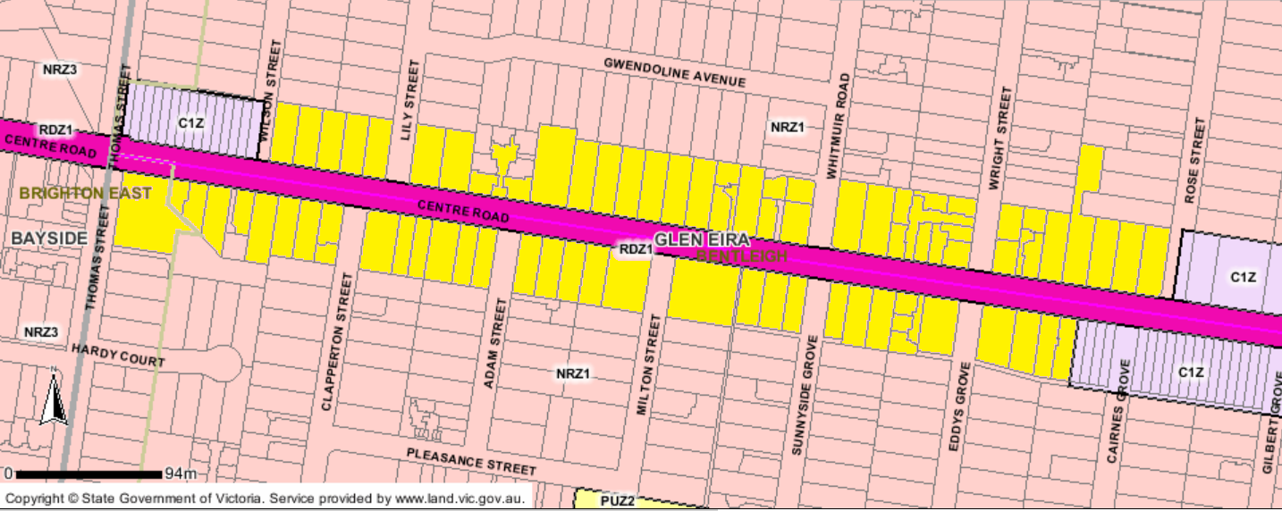
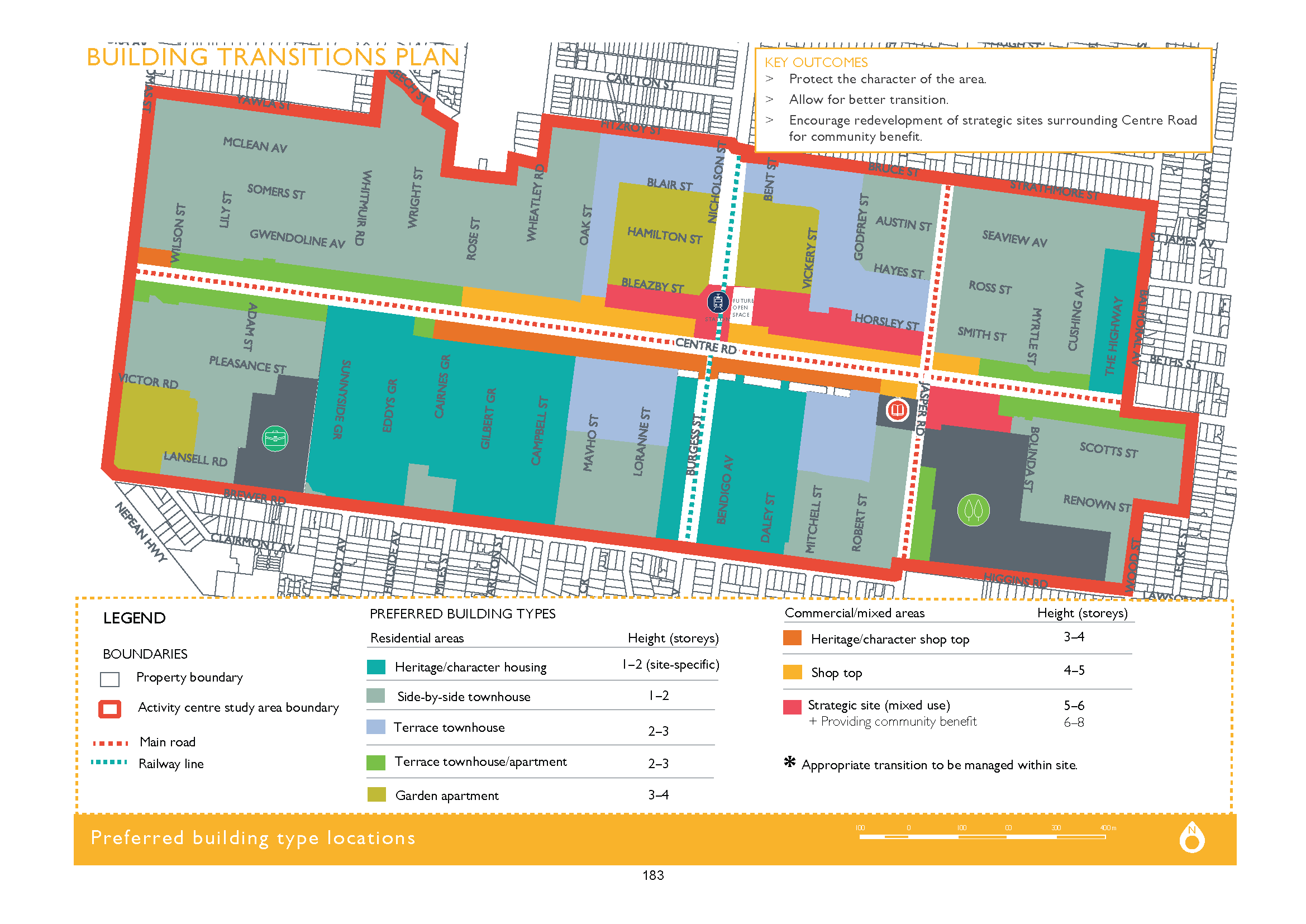
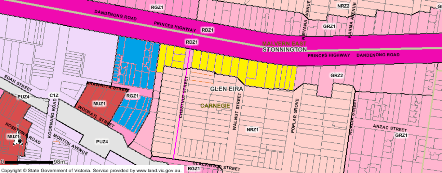
Presented below are two screen dumps which show what Amendment C148 created plus the height limits for each of these Design and Development Overlays – ie DDO9 1 AND 2 were for a preferred height of 7 storeys and DDO3 was up to 4 storeys. Please note that all of these preferred heights are now well and truly exceeded according to these ‘concept plans’ – and not by a storey or two, but by up to 5 storeys.

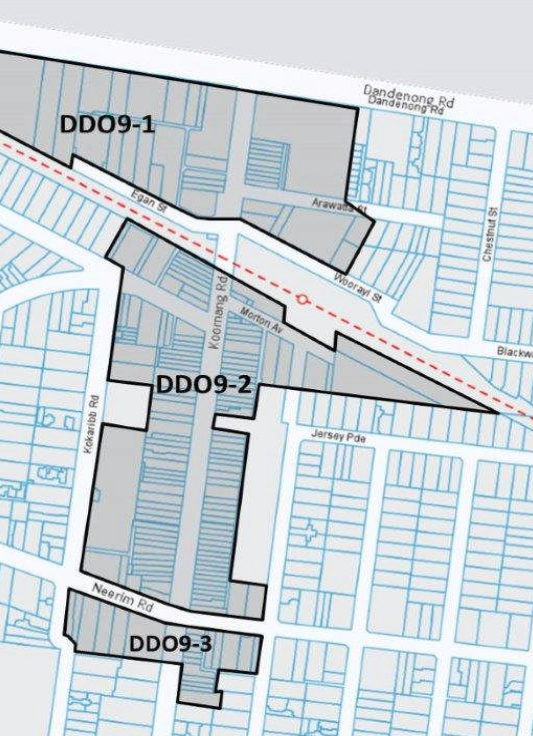
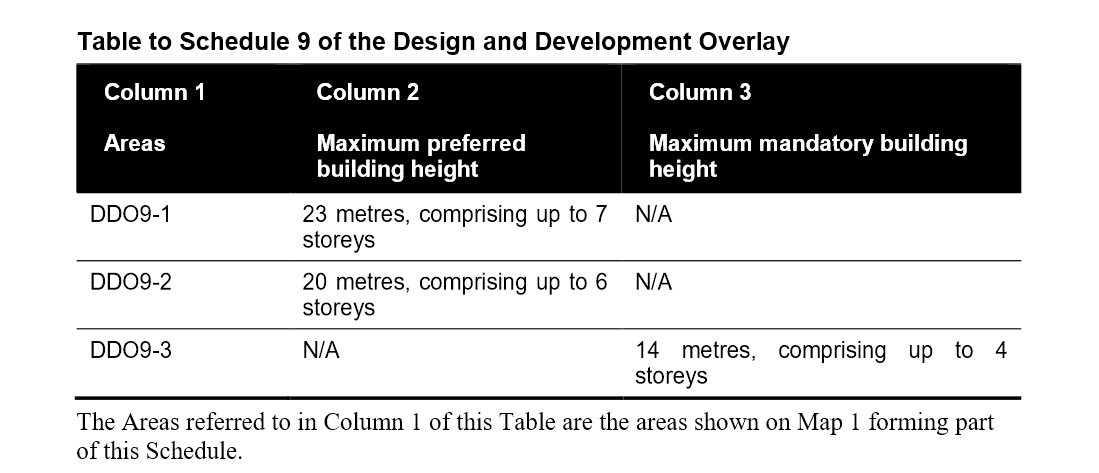
Below is what is proposed –

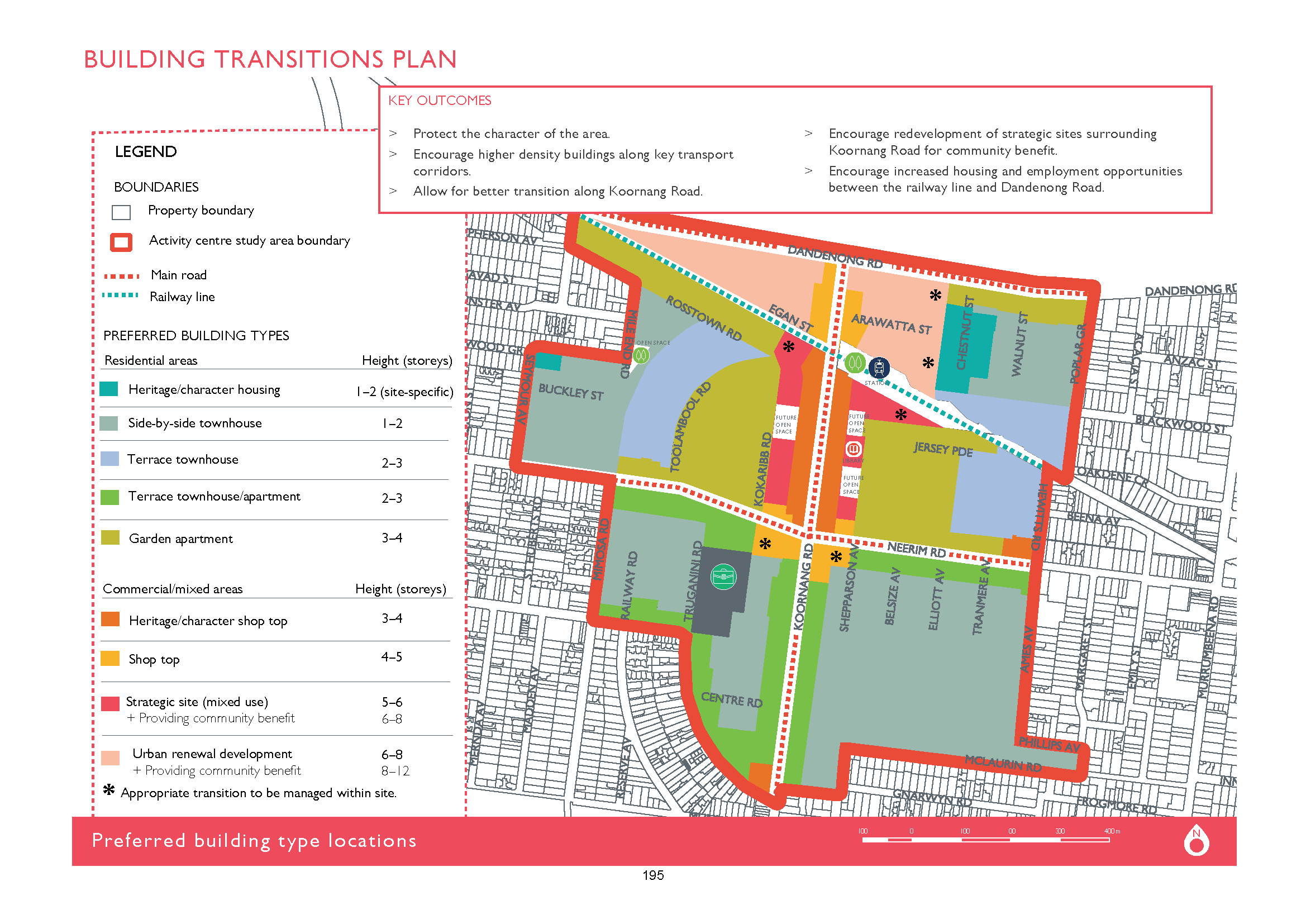
As with the Bentleigh ‘concept plan’, countless properties are now in the firing line for higher and greater development. Here’s a summary –

  • Properties currently zoned as Neighbourhood Residential (NRZ) along Rosstown Road suddenly find themselves as candidates for 4 storey buildings. (the light green in the above).
  • The same applies for those homes at the end of Chestnut running past Walnut (yellow in the map below
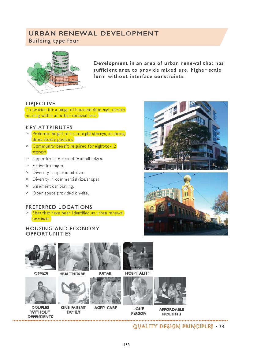
  • The sites coloured blue in the following map now indicate homes that are currently 4 storeys, but according to this document can have potentially 12 storeys! (ie the ‘urban renewal devopment’ sites). Please also note that Chestnut Street is heritage/nco terrain, so we have the potential for 12 storeys to hover over 1 and 2 storeys!

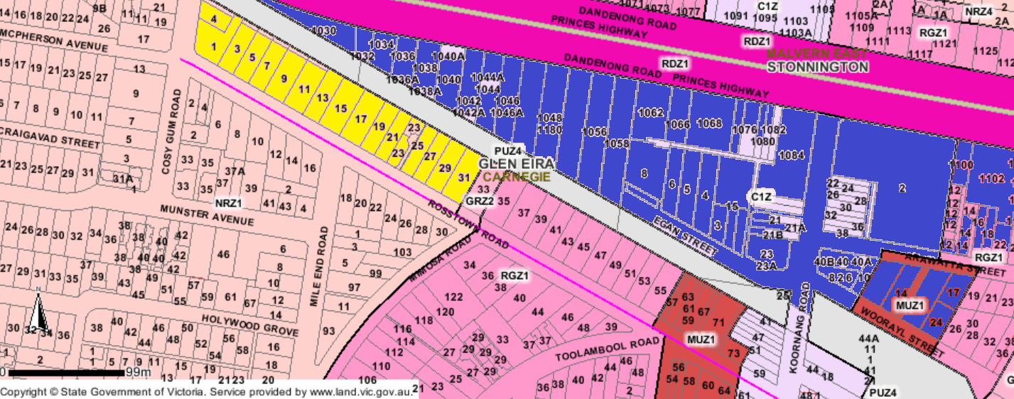
It gets a lot worse too –

  • Koornang Road, Truganini Road homes are now also candidates for 3 storeys, whereas they are currently zoned for 2 storeys (yellow)

Whether or not the apparent change along Mimosa from 4 storeys to 3 will make much difference remains to be seen given that there are already at least 2 major 4 storey developments to be found there.

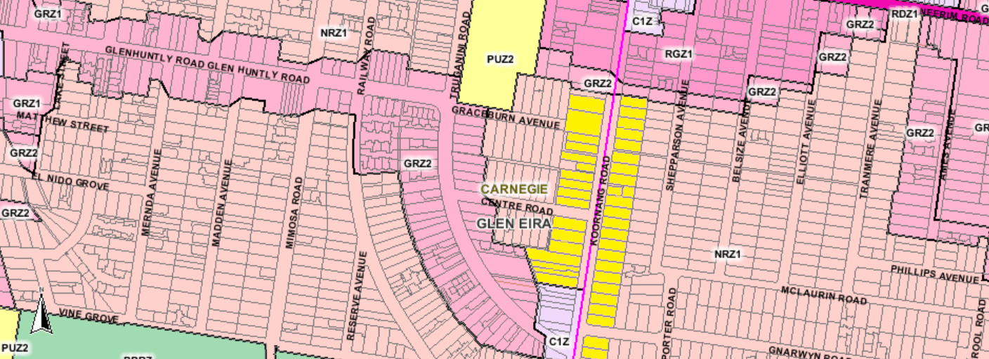
As with the Bentleigh plans, the unbelievable changes occur in those red and orange sections marked for 12 and up to 8 storeys (‘community benefit’) – remembering that council’s mantra was a limit of 7 and 6 in these areas. There’s plenty more that vigilant residents should be able to pick out. This is merely a short summary of the proposed changes that does no favours for Carnegie and portrays once again planning that is incompetent, dictatorial, and totally out of step with community expectations.

There’s simply no other way to say this except that residents are being screwed! and deliberately so. The ongoing rhetoric (aka spin) was that the structure planning process was finally being undertaken to provide more protection and certainty for our neighbourhoods. The only certainty we can see is that the vast majority of proposals for our activity centres are there to lend a further helping hand to developers.

The release of the latest documents makes a complete mockery of the Bentleigh and Carnegie interim height amendments – where the vast majority contained ‘preferred maximum heights’ instead of mandatory anyway. But council has really surpassed itself this time. Instead of 5 storeys preferred for a large part of Bentleigh we now have the possibility of 8 storeys and potentially hundreds of properties now available for 3 storey development when previously they were zoned for two storeys. Carnegie is even worse. Instead of 7 storeys preferred, large areas are now set for 12 storeys and some of these directly abut 4 storey zoning sites. No explanation for these changes have been forthcoming. No strategic justification has been forthcoming. No accounting for public open space, parking, infrastructure, costings, time frames, or anything has been provided. This isn’t planning. It is a deliberately deceitful and incompetent process designed to benefit both political and financial interests.

In this post we concentrate on explaining what is in store for Bentleigh according to the published information. We’ve uploaded again their ‘height’ diagram –

What is proposed

  • Both sides of Centre Road running from Thomas St to Jasper Road will now be available for at least 3 storey buildings. (coloured light green in the above map). These properties are currently zoned Neighbourhood Residential. The sites marked yellow on the following planning map show what is about to happen to this zoning and how many properties are impacted in just this strip of road.
  • Properties running along Jasper road and abutting the Reserve will now also be rezoned to accommodate 3 storey dwellings from their current zoning of 2 storeys (NRZ)
  • The ‘heritage shops’ at the corner of Thomas and Centre Roads can now be 4 storeys
  • Mitchell and Robert Street appear to have half of the lengths of their streets now in the 3 storey category. This is changed from the previous 4 storey – however the three storey limit is vastly expanded and now includes many properties that are currently in the NRZ area.
  • The above also applies to Mavho and Loranne. Problem is that many in these streets are already 4 storeys so the horse has well and truly bolted.
  • Council also has these fascinating categories of ‘Terrace Townhouse – 2-3 storeys’ and Terrace Townhouse/apartment – 2-3 storeys). We wonder how council can control the building of a ‘townhouse’ as opposed to the 3 storey building of apartments?  Another wonderful loophole for developers?
  • On heritage we have the superb get out of jail clause that states ‘site specific’. Exactly what does this mean? Will the current RGZ zoning for Bendigo and Daley streets suddenly become NRZ since this is categorised as ‘1-2 storeys’? We won’t hold our breaths on this one since the properties there will undoubtedly not meet the ‘site specific’ requirements!
  • The real concern is all those areas marked as ‘strategic sites’ – ie corners of Jasper and Centre; Horsely and Bleazby. (northern sites marked yellow on the map below). These are earmarked for anything up to 8 storeys depending on the wonderful vague criterion of ‘providing community benefit’! Translated that means flogging off public land for commercial and residential development. Please also note that some of these areas directly abut 2 storey zones. Quite incredible when we get Amendments that wanted a maximum of 5 storeys a few months back throughout the centre and now council decides (with no strategic justification) that 8 storeys could be acceptable!

CONCLUSIONS

When a council repeatedly ignores resident aspirations as Glen Eira has done for years and years and follows its own secret agenda(s) then democracy is really dead. More importantly, when not a single word is provided to justify any of the conditions contained in these draft plans then questions must be asked as to the real agenda and what deals have already been signed off on? Surely it is the role of councillors to ask questions, demand facts and figures and most importantly to represent their communities. This they are spectacularly failing to do on a regular basis. In short, residents are being screwed good and proper via this sham of consultation and its results.

The real questions that must be answered are the same old ones we’ve been carping on for ages –

What is ‘capacity’?

Why the emphases on more and more development when Glen Eira is already one of the densest municipalities in the state and is well and truly doubling if not tripling its required dwelling quotient?

How much is infrastructure going to cost and who will pay?

Finally, by way of contrast here is a screen dump from a recent Moonee Valley council meeting where lo and behold their councillors had the gumption to ask some very pertinent (public) questions! In Glen Eira timelines change every week. In Glen Eira we have no idea how much the implementation of even a fraction of these proposals will end up costing. Nor do we know who will pay. Would similar questions even dawn on our all so compliant councillors? And would they in fact even be told the truth?

Set down for decision Tuesday night is an application for a 6 storey building with 33 units, 6 shops, basement car parking and the waiver of parking spots for the shops and visitors, plus a loading bay. The site is along McKinnon Road between Wheatley and Jasper. The officer’s recommendation is to approve a permit.

We highlight this item for several reasons:

  • McKinnon is one of the smallest ‘neighbourhood centres’ – now officially an activity centre. Yet according to council’s planning scheme it sits well below its so called ‘urban villages’ of Bentleigh, Carnegie and Elsternwick. Thus we have the insanity of council’s application for height limits of 5 storeys in Bentleigh and now six storeys is viewed as acceptable in McKinnon!
  • Readers should also remember Amendment C143 where councillors changed an advertised amendment from Mixed Use Zone of 4 storeys in McKinnon Road, to a zoning of General Residential Zone (3 storeys) because they argued that 4 storeys was too much. Community opposition does work wonders!
  • This application is supposed to have 6 shops ranging in size from 53 square metres to just over 90 square metres. McKinnon has no bank, no supermarket, no butchers, no fruit shops, no clothes shops, and nothing really except cafes and more cafes. How much employment will be generated by a 53 square space is debatable – especially since council’s consultants predict a decline in ‘retail’ of thousands by 2036.

We have commented time and again on the lack of transparency in council officer reports for applications. This report is no different –

  • Instead of highlighting the number of one bedroom, two bedroom apartments proposed, the report lumps together the number of 1 and 2 bedrooms so that it is impossible to determine the percentage of one bedroom compared to 3 bedrooms. Worse still is the inclusion of totally illegible plans. When council spends millions on IT systems, surely it can provide images that are capable of being read. Is this deliberate?
  • The application has a deficit of 9 car parking spaces for its shops and 2 spots for visitor car parking. The recommendations on shop parking are far from transparent when we get sentences such as – Given the location of the site and proximity to residential areas, it is recommended that all visitor car spaces (6), and at least two car spaces for each commercial space be provided onsite. What is not spelt out is that this only totals 12 parking spots when the legislation required 16. Thus a waiver of 4 spots and no mention of loading bay or any reason for this largesse!
  • The traffic department’s view is also bereft of justification. All we get is this single sentence – Transport Planning is satisfied with the number of customer car parking spaces that has been provided for the shops
  • The best however is to be found in this incredible paragraph that is meant to justify everything but which conflicts completely with the current planning scheme –

The proposal has an overall maximum height of 19.96 metres. While the proposal will undoubtedly be taller and more robust than adjoining existing development, it is considered that it represents what policy expects in terms of change given the size of the site, the emerging built form in the immediate area and its strategic location. 

Where in the planning scheme does ‘policy’ envisage buildings higher than the major activity centre of Bentleigh?

Where in this area is there another building of this height?

Why is it acceptable to have a six storey building towering over a three storey building at its rear, when council first refused a permit in Caulfield North because it was to be a mere 2 storeys higher than its surrounds?

Nor are we talking about a really huge site. It is barely 1150 square metres and of course is not mentioned anywhere in the report!

Nothing changes in Glen Eira’s pro-development agenda. Officer reports are abysmal, deliberately vague and most importantly either conflict with the planning scheme itself or provide practically nil justification for the final recommendations!


A very long post, but incredibly important.

Following months and months of public consultation on structure planning for Glen Eira’s activity centres we finally get the first glimpse of the ‘design guidelines’ for Bentleigh, Elsternwick and Carnegie and the ‘big picture’ for the other activity centres (neighbourhood centres).

Residents should be very, very alarmed with what is another nebulous and poorly explicated effort from Council. The only thing that is clear is that very little of what residents have stated they desire has been incorporated into these waffly documents. For example:

  • Height limits of 3 to 4 storeys, especially in ‘neighbourhood centres’ was stated time and again. It now is on the drawing board that suburbs such as McKinnon, Ormond, Bentleigh East,etc can expect buildings  much higher depending on zoning. Needless to say not one single word of justification is forthcoming as to why 8 or 12 storeys is warranted anywhere. Further, another item in the agenda recommends that a permit be granted for a 6 storey development in McKinnon Road, McKinnon. The rot has well and truly started for our neighbourhood centres!
  • Below is 2 examples of what we mean. Please read carefully

As for the major activity centres themselves we find the following:

  • There is still the intent to flog off public land for high rise commercial development
  • Multi storey car parks are still in the picture
  • Structure plans will NOT BE forthcoming by December 2017
  • Parking plans still belong to the ‘never-never’
  • Heritage is ‘expendable’ and dependent on where it is – ie it is okay for 3 and 4 storeys in heritage overlays
  • The only potential concession to heritage from Bentleigh is the Bendigo & Daley Streets overlay (which is zoned Residential Growth Zone). Given that the map below is shaded green but also includes the ‘site specific’ addendum, we have no idea whether this means these streets will be rezoned to 1 or 2 storeys, or whether 3 and 4 storeys are still on the cards.
  • The red areas identified as ‘strategic site’ and given the green light for between 5 and 8 storeys are a major worry since they abut areas zoned General Residential – ie 3 storeys.

Conclusions

  • It is obvious that council is gearing up for more and more development. These plans are merely facilitating this process and totalling ignoring the vast majority of community feedback.
  • There is no intention of reviewing the zones – only expanding the borders of the activity centres.
  • No real strategic justification exists for any of the height recommendations
  • Census figures are available, yet these documents are still touting 2011 figures!
  • Urban design as carried out by every other single council contains information on setbacks etc. This is non existent in these documents.
  • Residents are being drowned in paper. That is undoubtedly the intention we believe. To provide not information, but dribs and drabs that are near impossible to decipher. There can be absolutely no excuse for the lack of proper legends, clear and precise images, and language that actually is more than spin and useless jargon.

We will comment in greater detail in the days ahead.

PS: We forgot to mention that readers need to pay careful attention to those areas now marked as light green and orange. In the current planning scheme these sites are zoned as NRZ (ie 2 storeys). They have now been given the ‘green light’ for 3 storeys. Also, the section at the corner of Brewer and Thomas Street is now earmarked for 4 storeys from its previous 2 storey height limit. Please also remember that only a short while ago a public question asked council whether they intend to rezone any NRZ sites to GRZ or RGZ. These documents provide plenty of evidence that countless properties will now become 3 or 4 storeys and possibly even higher. We do not believe that council wasn’t aware of this at the time of their ‘response’ – since it definitely wasn’t an ‘answer’ to the public question.

The table below features data from the Planning Permit Activity government website. The numbers are for the past financial year and reveal the quarter by quarter number of permits granted for NET NEW DWELLINGS – ie not houses replacing houses, but the increase in dwellings per application. These are also not building permits and the vast majority of these new dwellings would not as yet have been granted their building rights.

We’ve listed neighbouring councils and those that Plan Melbourne has now designated as belonging to the same group – ie Bayside, Stonnington, Boroondara and Glen Eira.

Source: https://www.planning.vic.gov.au/publications/planning-permit-activity-in-victoria

PS: We’ve made an error. The Boroondara total should be 1077 and the Port Phillip one should be 2049! Apologies.

We’ve commented before on what can only be described as council’s profligacy in spending millions of dollars on ‘upgrades’ that residents have not asked for nor truly want. The latest example is the ‘upgrade’ to Harleston Park playground. The budget has set aside $650,000 plus another $330,000 for public toilets. We believe that by the time landscaping occurs, the costs will be well over a million dollars. Remember, council has yet to prove it can stick to any budget,  with major projects time and time again costing far more than first indicated.

On the one hand we have councils screaming poor because of the State Government’s rate capping. On the other hand millions of dollars are being expended on projects that are highly questionable. Recent examples of highly suspect proposals that have raised the ire of the majority of residents include:

  • The purchase of 9 Aileen Avenue, South Caulfield for $2.1m and which is now rented out.
  • The creation of a ‘park’ between Fitzgibbon and Eskdale for the stated amount of $450,000 – both of these within a stone’s throw of nearby parks
  • The expenditure of $11m that council admits to for Booran Reservoir, but which we believe is far in excess of this cost – plus an area of urban forest equalling 11% of the site that is closed off to the public entirely.

All of these projects have not been embraced fully by residents and the current feedback on the Harleston Park proposals continues this trend. The vast majority of responses question the attempt to change a passive area into another Booran Road type Disneyland. More importantly, we have to wonder at the wisdom of council’s budgeting and its agenda. For example:

  • Why is Camden Ward the flavour of the month, especially when areas such as Carnegie are experiencing the greatest amount of development and no attempt has been made to increase public open space in this precinct?
  • Council, unlike other municipalities, has no playground policy that we know of. Thus ad hoc planning again!

The central question however should be whether residents would prefer spending more of our money on expanding open space instead of pouring more and more concrete into existing open space? – remember the $282,000 for concrete plinths!

It all comes back to priorities. Yes, facilities need upgrading, and yes, this can be expensive. But we absolutely reject the over-the-top spending on ‘upgrades’ that other councils can do for a quarter of the cost because their vision and programming is so vastly different. What is needed in Glen Eira in our view is not mega palaces that cost the earth but a concentration on expanding existing open space. That is impossible when the vast majority of the open space levy is spent on proposals such as the Harleston Park redevelopment.

Melbourne council areas with the biggest growth in apartment projects

Christina Zhoutwitter Domain Reporter Jul 15, 2017

Alistair Howe was gutted when he found out his neighbours would be selling their two adjoining Caulfield North houses to apartment developers.

Within an hour, he decided to join them – spurred on by the thought of living next to a multi-storey building – and offered up his family home of 18 years for sale.

The neighbours hope their combined 1717-square-metre block on Hawthorn Road will capture increasing developer interest in Glen Eira, where significant levels of apartment construction is planned.

There were 307 units approved in projects of at least four storeys in Glen Eira during the five months to May — more than double the 135 approved at the same period last year, an analysis of Australian Bureau of Statistics building data by Domain Group chief economist Andrew Wilson showed.

The number of approvals in Glen Eira trails those given the green light in the councils of Melbourne, Stonnington, Yarra and Boroondara, which alone had 559 apartments approved — more than quadruple the 119 last year.

Greater density is generally encouraged along transport corridors to protect the character of the neighbourhoods.

Mr Howe said he raised a family with five children in his three-bedroom house, and expected to live there until he was “too old”.

He added he had “mixed emotions” about the sale, but decided to sell together because it made more financial sense.

“I felt gutted initially because I suddenly thought ‘well, I don’t want to have a three-storey apartment beside me,’” he said. “Then within an hour, I made the decision that I’d join their sale.”

The owners are hoping for between $5 million and $5.5 million for the row of three houses, and would split the sale price based on their land size.

The successful bidder at the July 26 auction would also have the first right of refusal to buy another neighbouring house, with a single dwelling covenant.

202 Hawthorn Road, Caulfield North 

Combining the properties would open up the site to larger scale developments, Gary Peer director Adam Joske said, and it could also achieve a premium of more than 10 per cent.

Although the City of Melbourne continued to record the most approvals for high-rise apartments, the number in the pipeline is weakening. There were 1357 apartments approved from January to May, almost 900 fewer than the same time last year.

Dr Wilson said there could be a perception from developers that the CBD market — where there had been record levels of development — might be over-supplied.

“But I do think it will turn around because the Melbourne market generally is still under-supplied,” he said, adding that prices were rising strongly.

Angie Zigomanis, BIS Oxford Economics senior manager, said tougher rules for foreign investors — prolific buyers in central Melbourne — could have had an impact.

Australian banks tightened lending criteria for offshore buyers against the backdrop of the Chinese government limiting the amount of money moving offshore. On top of this, the Victorian government more than doubled the stamp duty surcharge for foreign buyers last year, from 3 to 7 per cent.

UDIA Victoria chief executive Danni Addison believed it was a case of the market adjusting to changes in planning policy, including height controls and setbacks in the CBD and the new apartment design standards.

“It takes people a while to go back to the drawing board in terms of their project feasibility and work out how to recast the vision,” she said.

Ms Addison said there was also a clear correlation between the increase in planned apartments in the inner and middle rings and demand.

Boutique developments in well-serviced areas such as Boroondara and Glen Eira appealed to downsizers who wanted to stay in the area and young families who could not afford a family home, she said.

Source: https://www.domain.com.au/news/melbourne-council-areas-with-the-biggest-growth-in-apartment-projects-20170715-gxadgh/

Glen Eira remains the development capital of the south east. The ABS figures above represent building permits granted this financial year and up to the end of May 2017 – ie 11 months worth.  We repeat that both Port Phillip and Stonnington are special cases given that the former has just on 25% of its municipality designated as Commercial and Capital City zoning, whilst Stonnington has triple the amount of land zoned Commercial in comparison to Glen Eira’s 3%.

The figures prove beyond a doubt that Council’s land use hierarchy has been a dismal failure in that the vast majority of development HAS NOT occurred in the Commercial areas but in quiet residential streets that unfortunately are zoned as General Residential.

Readers should also note the percentage of houses compared to units for each municipality – again showing Glen Eira’s concentration of apartments, in suburbs that are already bursting at the seams with overdevelopment. Yet the revealed housing report for the current structure planning, would appear to indicate that there is more development in council’s agenda given the upgrading of 3 local centres to Neighbourhood Centres. This can only mean one thing – more land to be earmarked as GRZ or RGZ! And of course, the above figures do not include the 1100+ apartments for Caulfield Village or the thousands that will end up at Virginia Estate.

The most essential questions remain unanswered by council –

  • What is capacity?
  • What is the maximum density?
  • What is the cost for adequate open space, drainage, etc and who will pay and when?

Council has published the Terms of Reference for its Community Advisory Group for the East Village project. Ostensibly, the creation of this advisory committee is a positive step, if somewhat belated in that the first draft of the resulting structure plan has already been set.

What concerns us even more than the question of timing,  is how  transparently this committee will operate, how it will report,  and how much notice will be taken of community rep views. The terms of reference (see below) do not fill us with confidence that this will be anything except another public relations exercise designed to provide the illusion of working with the community.

Please note the following:

  • No mention is made of councillors. Are they excluded entirely from any involvement in this committee – from selecting residents to actually partaking in the meetings?
  • Why is all responsibility granted to officers in terms of selection, etc?
  • Why is there no formal council resolution that endorses these terms of reference?
  • Why is there no mention of reporting requirements to the wider community?
  • Why is there the possibility that the Victorian Planning Authority and others may attend, when it was specifically stated by the Mayor that this is a committee expressly set up to work exclusively with council?
  • Given that the next iteration of the structure planning work is supposed to be in July (ie urban design/building guidelines) then how many times will this committee actually meet?

At the last council meeting, and following the wide media coverage, this resolution was passed –

Moved: Cr Delahunty Seconded: Cr Silver

That Council requests the Minister for Planning to prepare, adopt and approve a Planning Scheme Amendment in accordance with Section 20(4) of the Planning and Environment Act 1987 for an interim heritage control over the property at 450 Dandenong Road, Caulfield North.

All well and good, but there is no guarantee that the Minister will accede to this request. Nor do we know whether council has in fact conducted any heritage evaluation of the building in order to provide sound strategic justification. In short, is this simply another example of an ad hoc reactive measure to recent publicity?

The same old questions surface time and time again –

  • Why is it that other councils can be so proactive on heritage?
  • Why hasn’t council allocated funds to ensure more than an ‘update’ of a ‘Reference Document’ that has existed for 15 years but never been included as such in the planning scheme?
  • Why must residents wait for at least another 2 years before there is the chance to include other properties such as the Dandenong Road one onto the Heritage listing in the Planning Scheme? Why can’t residents start nominating sites now? Why can’t the work begin now?

In March 2017 Council applied to advertise its ‘updated’ policy and to include this document only as a ‘Reference Document’ in the Planning Scheme.  The officer report specifically noted the following –

What should also be noted by readers is that Reference Documents have very little influence in decision making as stated in the Government’s Practice Note 13 — –Reference documents have only a limited role in decision-making as they are not part of the planning scheme. They do not have the status of incorporated documents or carry the same weight. (Planning Practice Note 13: Incorporated & Reference Documents)

Stonnington by contrast has done its homework and has come up with an amendment that seeks to include 60 new sites at the same time into its Heritage Overlays. (Agenda item for July 2017) None of this one by one ad hoc approach that is favoured by Glen Eira and which according to Stonnington is far from cost effective.

Conclusion?

We see no reason why Glen Eira cannot proceed along similar lines to Stonnington – unless of course there is no money for heritage consultants. That comes back to priorities. When a budget is willing to spend $282,000 on concrete plinths, instead of using this money to preserve our past, then we claim that council priorities are way out of kilter with what most people would want. Of course, we have never been asked what our real priorities are and where we would like our money spent!

The tragedy is that by the time council gets around to investigating what other properties should be included in a heritage overlay it will be too late.

« Previous PageNext Page »