GE Consultation/Communication


A short post alerting residents to the fact that council has published its draft budget, community plan and also included plenty of planning applications in the current agenda – a massive 555 pages!

We will report on the first two in much greater detail once we have had the time to fully digest the documents. What follows are simply some overall first impressions:

  • The community plan is presented in a different format completely. The old ‘faults’ are still there however – ie. very little correlation between ‘objectives’ and assessment of these objectives. For example: on the theme of ‘informed and engaged’ one of the criteria for evaluating ‘success’ is recorded as “Rates per assessment will remain at the second lowest level of all metropolitan municipalities”.
  • If council is truly concerned about ‘transparency’ then we have to question why on page 101 of the draft budget council insists on highlighting the percentage increase for bins, rather than the actual cost increase – ie. “240 Litre Bin 1.95 per cent Increase” etc. Residents shouldn’t have to plough through hundreds of pages to be able to work out how much charges have increased. This is the first time we believe that this kind of presentation has been done.
  • For all the talk about open space expenditure, there appears to be zero allocated for the 2017/18 financial year according to the Strategic Resource Plan!
  • Rates of course are going up, as is every other single charge. Council has however stated that it will not be seeking a higher rate (mandated 2% increase) via an appeal to the Essential Services Commission.

On other matters –

  • Parking restrictions around the hospital will not change – despite protest after protest and nothing really forthcoming from the proposed ‘advocacy’ to Caulfield Hospital
  • More applications in for extended heights – Neerim Road going for 4 storeys when a previous permit application was successful for 3 storeys. Officer recommendation? – permit. We are also mightily amused by this argument in favour of the permit – The new top floor balcony is proposed to be setback approximately 6 metres from the street. It is considered that this setback is appropriate having regard to the approved setback of the fourth storey of the building to the east (253 Neerim Road) at approximately 6 metres.
  • For another application council officers see nothing wrong in waiving 5 car parking spaces for shops!

Watch this space!

We’ve received the following email –

“Over the last few years, Bentleigh residents have been actively lobbying Council to put in the right controls and plans for future developments within the area.  As an outcome of this lobbying, some interim height controls have recently been introduced and Council is now also undertaking a Bentleigh shopping centre and surrounds structure planning process. This structure plan will significantly influence future development and FYI we have attached the preliminary draft.
A Community Forum is to be held on Wednesday 3 May, 6.30pm–8.30pm at the Bentleigh Senior Citizens Centre, 2 Arthur Street, Bentleigh to further discuss this preliminary plan.  It is important that residents attend to express views on this draft plan. 
 
Our thoughts on the preliminary plan are:  
  • There is no meaningful increase in open space and this is an issue with increasing development and also the general lack of open space in Glen Eira (lowest in Melbourne).
  • It is proposed that the existing car parks are to be consolidated into a multi-storey with the remainder to potentially be converted into more residential developments. This is not acceptable (Stonnington for example are doing one underground car park and developing open space above).
  • There is limited if any innovation or creativity in the plan.  
  • It is proposed that the library be relocated ($20M plus cost) however this was not identified as a need by residents.  (perhaps Council wants to sell off the current library site for a major development?). 
  • There is no direction included for future development heights. 
In summary, we believe that more work needs to be done to deliver a plan that is consistent in quality with other local government areas.  Please attend the community forum to again ensure Council clearly understands the views of residents.  Numbers are important, please also forward this onto friends.
Kind regards,
Centre Road Bentleigh”
centreroadbentleigh@gmail.com
++++++++
The relevant document is uploaded HERE

The so-called ‘Tranformative Concepts’ for dealing with the issue of parking to in our activity centres basically proposes

  • To flog off to private development as much of council owned car parks as possible – the terminology became ‘repurposing’!
  • To replace these car parks with one single above ground car park of at least 2 or 3 storeys.

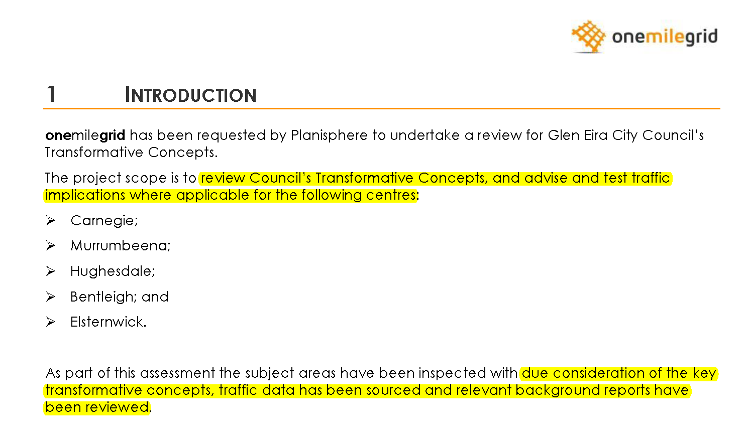
One Mile Grid was then commissioned to survey ‘traffic’ flow in various streets. Their brief is defined as

Without stating the obvious, traffic flow and parking should be two distinct areas. It appears that council is determined to conflate both issues in the attempt to provide support for its highly questionable  recommendations! Not surprisingly, the results of the One Mile Grid analysis for Elsternwick, Carnegie, Bentleigh concluded that – The results show that all intersections analysed are currently operating under ‘excellent’ conditions during both the morning and afternoon peak hours with minimal queues and delays experienced by motorists. Only Orrong Road brought up a ‘good’ condition report rather than ‘excellent’. Many residents travelling along these roads/streets would beg to differ!

We are not traffic engineers. We are simply residents attempting to understand how such results can lead to the recommendations when:

  • No account has been taken of anticipated residential developments in the area
  • No account has been taken of car parking spots in nearby residential streets
  • No account has been taken of council car park occupancy rates
  • No account has been taken of occupancy rates in surrounding streets
  • No account has been taken of car ownership in the area
  • No account has been taken of parking restrictions in the area
  • No account has been taken of ‘through’ traffic – ie not remaining in the activity centre itself but just passing through

If council is indeed sincere about providing adequate car parking in its activity centres, then one must expect far more than a highly suspect report that does nothing more than focus on ‘traffic flow’ at certain intersections and concludes that all is hunky dorey for the most part and that public land can be flogged off for more private development.

By way of contrast we urge all residents to read the following that comes from Moonee Valley council’s amendment seeking to introduce both a parking overlay for the Moonee Ponds Activity Centre and a developer contribution of up to $13,000 per each car parking waiver. Then ask yourselves would Glen Eira ever attempt something like this given its pro-development agenda? We’ve uploaded the Moonee Valley traffic analysis, (a 175 page document) HERE

A huge gulf exists between resident responses to the ‘surveys’ on ‘transforming’ our activity centres, and what is portrayed as the ‘results’ of this ‘consultation’. The McKinnon report is another example of a work of fiction that fails to accurately represent what residents said – especially in the category of ‘private development’. Here is the pie chart claiming to depict the results –

Please note the following:

  • To claim that ‘there was no clear agreement on suitable building heights’ is rather rich given that residents have never been asked – what do you think is an appropriate development height in any of the activity centres!
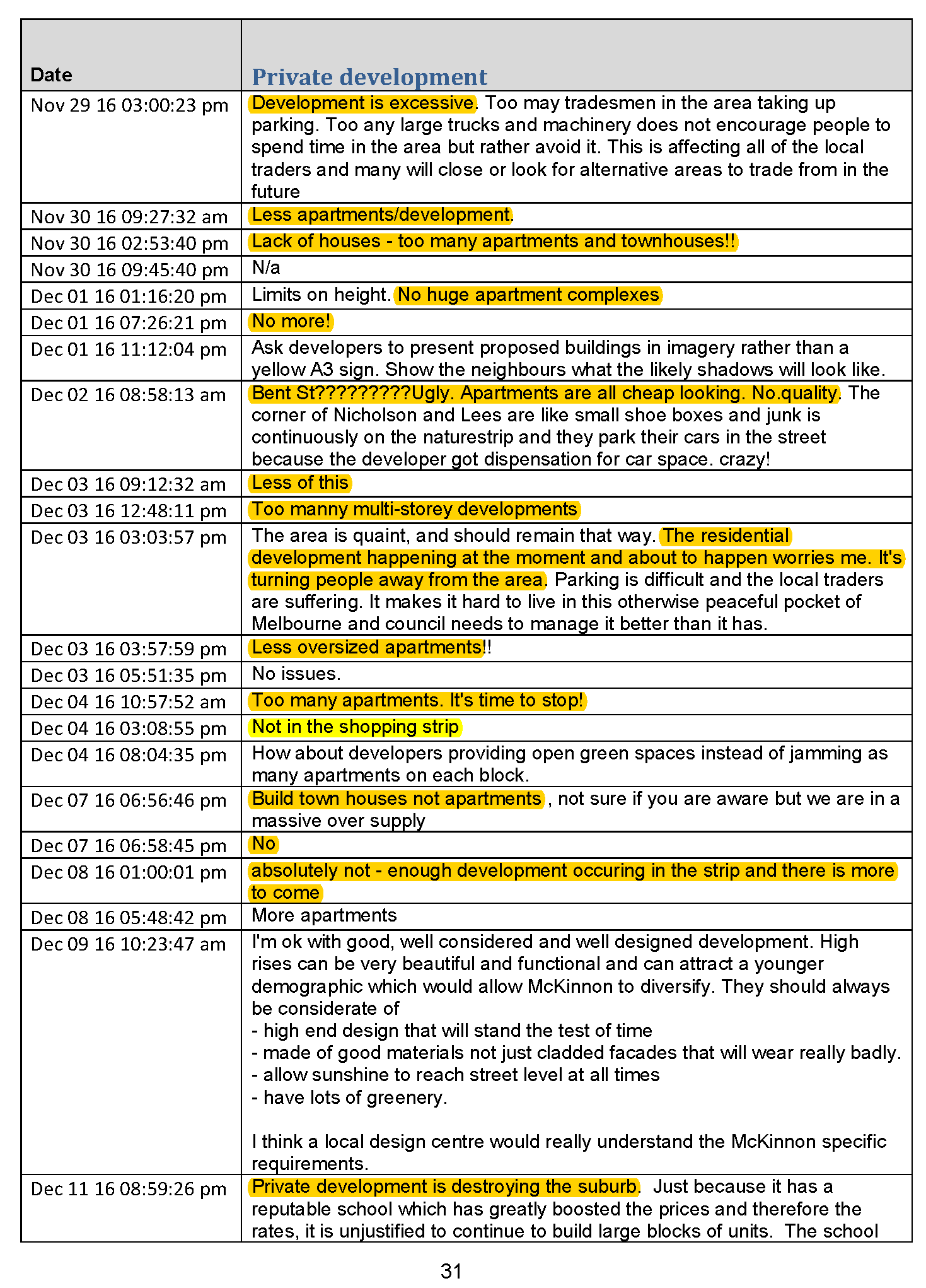
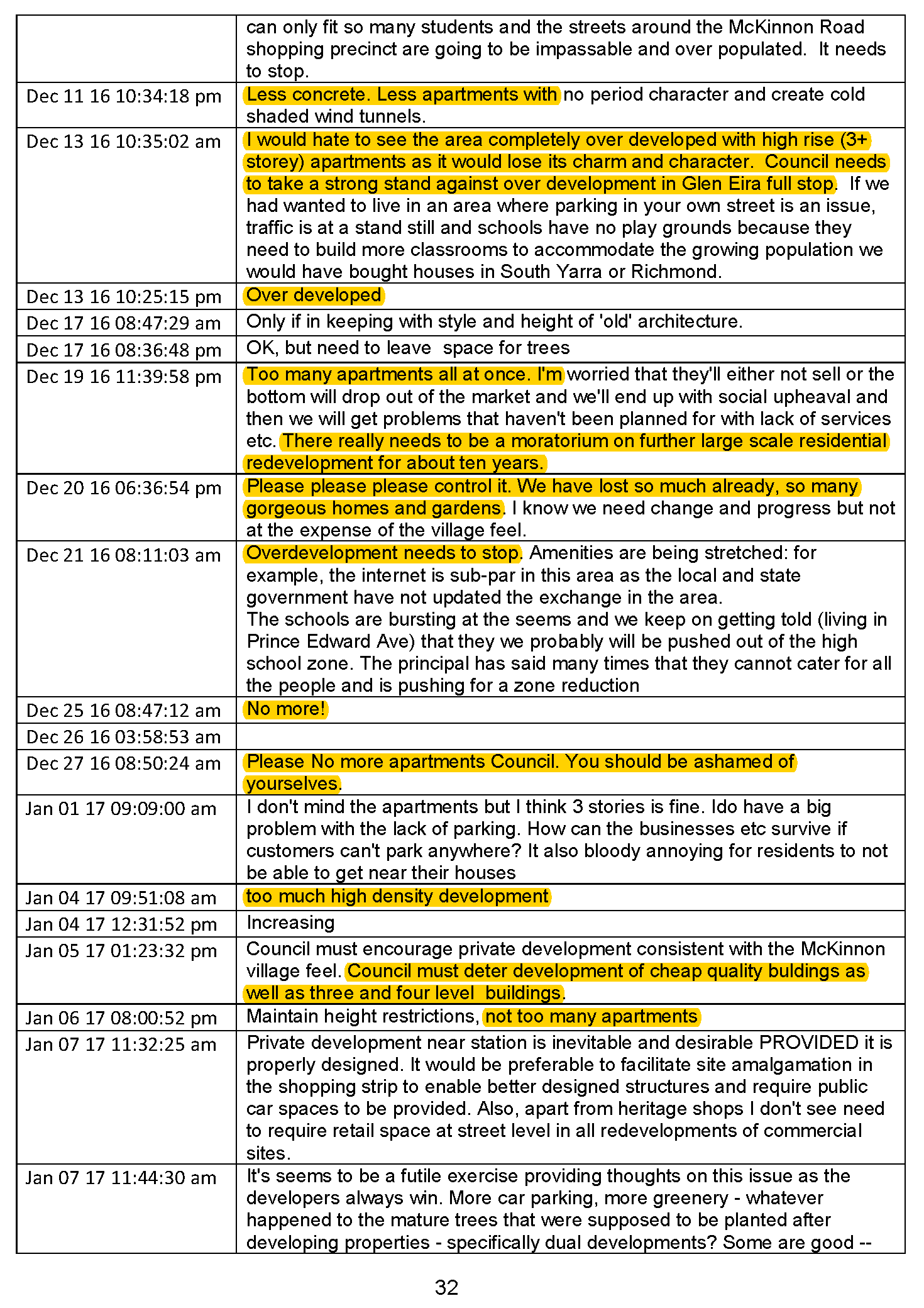
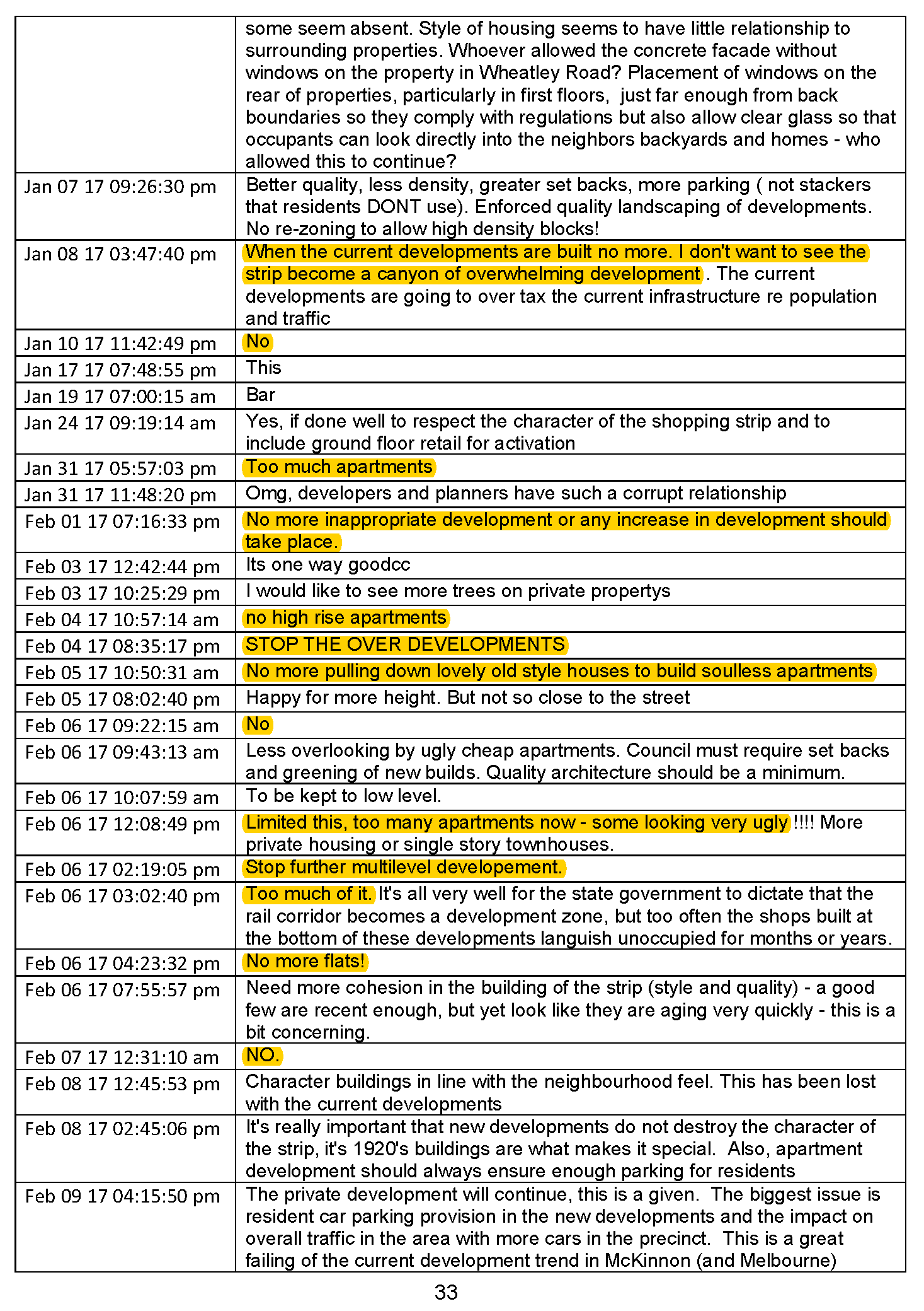
  • The claim that only 27.8% of comments were opposed to development is utter nonsense. On this topic of ‘private development’ there were 64 valid responses. We’ve ignored blanks and those marked as n/a. Of these 64 responses, a clear 39 were opposed to development (highlighted in orange below). That makes it 60.93% of responses were opposed to development
  • The report also states that ‘Many felt it was the popularity of the suburb services, particularly the high school’ that resulted in ‘increased population’. A more honest response could have been that increased population is a result of the zoning. Further, of the 64 comments only 3 mention schools at all – that is 4.68% – yet it rates a prominent mention in the report!

Please read the following comments and judge for yourselves as to the validity, honesty, and accuracy of this ‘consultation’ report.

Alarm bells should be ringing loud and clear for residents as a result of council’s latest news item on its proposed planning agenda. (See: http://www.gleneira.vic.gov.au/Council/News-and-media/Latest-news/Transforming-our-neighbourhood-together)

Several things are clear:

  • There will NOT BE ANY STRUCTURE PLANNING for the myriad of neighbourhood centres in the foreseeable future. All that will happen is the production of an Activity Centres Strategy which will consist of a broad ‘vision’ and ‘guidelines’ that will undoubtedly go into the Municipal Strategic Statement (MSS), plus its probable inclusion as a ‘reference document’.
  • The promise of community representation on a steering committee for the Virginia Estate development from the start of the project (strongly voiced by Athanasopolous and Delahunty) appears to have been conveniently forgotten given this carefully phrased announcement –

In order to form a community led vision and key objectives for the precinct, we are conducting our own community consultation. This will inform the development of a structure plan, which will guide what can be built on the site.

Visit www.gleneira.vic.gov.au/eastvillage to tell us what you would like East Village to look like into the future.

The opportunity to provide feedback on this stage closes Sunday 16 April.

There will be further opportunities to provide feedback once a draft structure plan has been developed.

  • Murrumbeena and Hughesdale, despite what the Transforming Concept document states, will not be part of the structure planning program. Instead, council will be getting ready for major ‘value capture’ development as a result of the level crossing removals – ie Recommendations to the State Government’s Level Crossing Removal Authority, with suggested projects for Carnegie, Murrumbeena and Hughesdale
  • Of greatest concern is the following –

We will use the community feedback on your concerns regarding development in residential neighbourhoods to develop new building and development guidelines.

There will also be a more detailed focus on Bentleigh, Carnegie and Elsternwick.

These guidelines will shape future development for land in activity centres zoned as Commercial One Zone, General Residential Zone and Residential Growth Zone.

No mention of reviewing the zones themselves or the borders of these zones. No mention as to whether these ‘guidelines’ will result in revised schedules or merely be part of the MSS. No mention as whether these guidelines will be a ‘one size fits all’ across all neighbourhood centres or will cater to the individual needs of each specific centre.

There is much in this media release that is (deliberately?) vague and even contradicts previous statements. What is entirely ignored, and of major importance is the Minister’s recent announcement of changes to Plan Melbourne via his gazetting of Amendment C110. The changes provide councils with the opportunity to rework their schedules and to provide clear ‘neighbourhood character objectives’ for both the NRZ and GRZ areas. This involves much, much more than ‘building and development guidelines’.

Booran Reserve playground in Glen Huntly could be best in Melbourne

Bianca Carmona, Caulfield Glen Eira Leader

April 1, 2017 12:00am

A CHILD’S smile might be priceless to most, but it comes with a hefty price tag of almost $11 million in Glen Eira.

The council has spent $10.8 million creating what could be Melbourne’s most expensive playground at Glen Huntly’s Booran Reserve.

It is almost twice the cost of the Royal Park Nature Play Playground next to the Royal Children’s Hospital, which opened two years ago and is considered one of Melbourne’s best.

By comparison, neighbouring Bayside Council has approved funding of almost the same amount ($10.48 million) to improve more than 60 play areas over the next 10 years.Booran Reserve in Glenhuntly will open soon.

The Leader asked Glen Eira council what bang ratepayers were getting for their buck, but the council refused to reveal a breakdown of the final bill, acknowledging only that the State Government had provided $700,000.

Leader can reveal the water-themed playground of the future boasts Australia’s first double-dome climbing net, custom-made play equipment, a water play area, outdoor gallery space, urban forest corridor and double flying fox.

Glen Eira Council infrastructure, environment and leisure director Samantha Krull said the reserve, which was formerly a reservoir, included a range of spaces that provided for play, activity and relaxation.

The construction of the playground at the corner of Glenhuntly Rd and Booran Rd is now almost five months behind schedule, building anticipation about its opening on Sunday.

Comments from the Glen Eira Residents Action Group were mostly positive, with member Vicki Howson writing: “Wow, looks fabulous … can’t wait to take my grandchildren here.”

But Ratepayers Victoria vice-president Jack Davis wasn’t impressed, saying the price tag was “ridiculous”.

“It’s an exorbitant use of ratepayers’ funds,” he said.

A Community Fun Day will be held at the reserve on Sunday, April 9.

The official opening will be held on Tuesday, April 11, by Victorian Minister for Innovation Philip Dalidakis.

Source: http://www.heraldsun.com.au/leader/inner-south/booran-reserve-playground-in-glen-huntly-could-be-best-in-melbourne/news-story/f132e57ea7cb7b1b7ebba5ca420d6230

CLICK TO ENLARGE

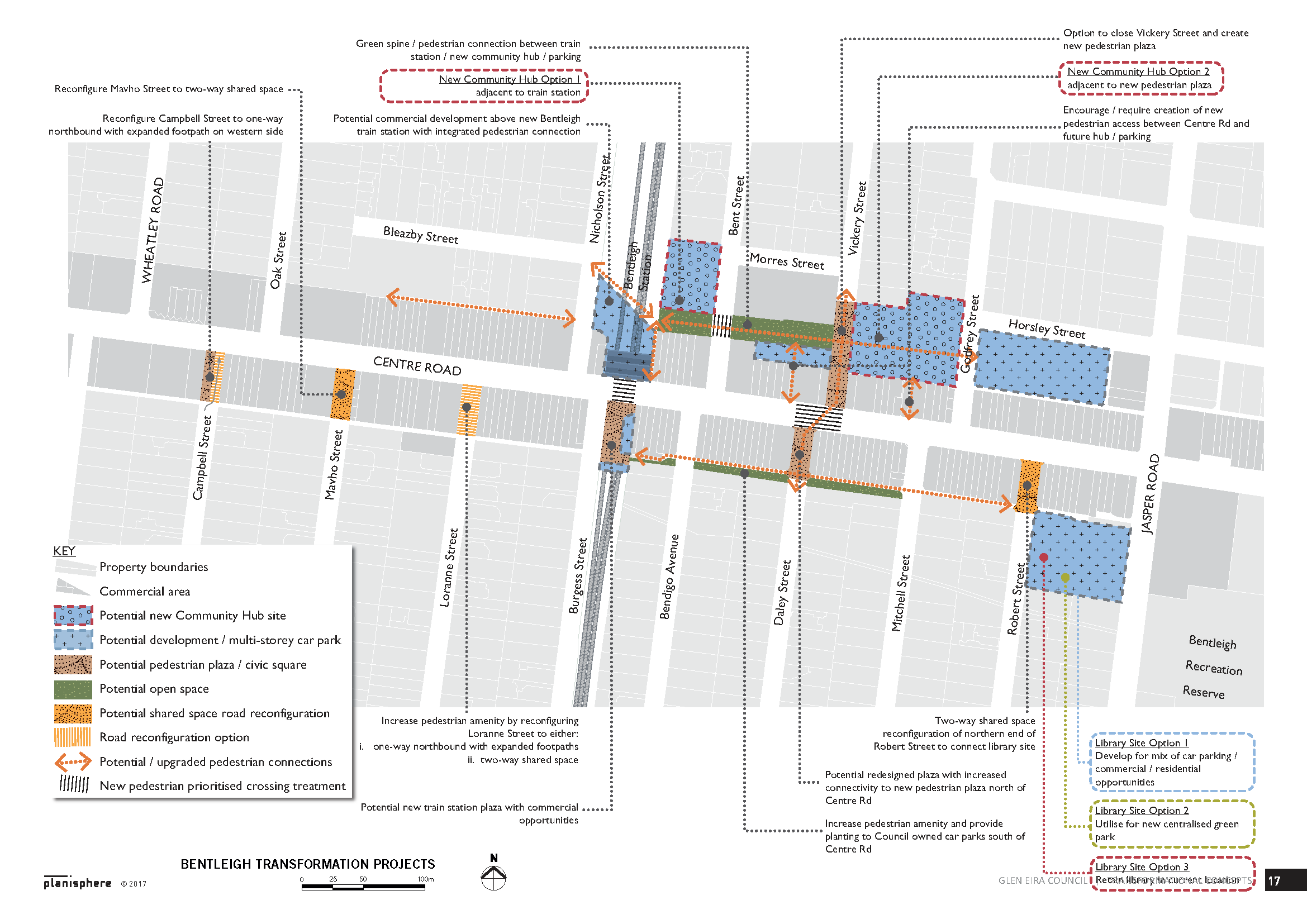
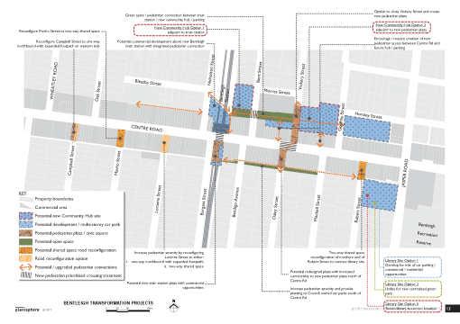
Every single resident should read the ‘transformative concept review’ created by Planisphere. As a strategic document that is supposed to set the vision for the next 20 to 30 years, it falls well short of the mark in our view. Our concerns with this ‘review’ are numerous. In a nutshell, we find:

  • The objective is to sell off as much public land as possible
  • Recommendations are impractical and impossible to deliver
  • Corporate memory is non-existent. This results in unbelievable profligacy.
  • The incorporation of recommendations that are not what residents said they wanted, or ignoring what residents stated
  • Inaccuracies of statement after statement

We will start off with an analysis of the Bentleigh ‘concepts’ and proceed with the bullet points made above as headings.

Selling off public land

The Bentleigh Activity Centre has 6 car parks (one of which council doesn’t even know if it owns – ie Aldi!!!). What is proposed in superb double-speak is a ‘repurposing’ – ie sell off- of some of these car parks to commercial interests and the creation of a multi-storey carpark of 2 to 3 storeys. No costings of course, no time scale, no nothing! Instead we are left with the ‘promise’ of increased car parking spaces. Yet, the sites of this new car park are also highly questionable. If all car parks go, then residents will be forced to congregate even more in one single high rise concrete structure. Will this create less patronage of the centre or more? What is the evidence to support either position? And why high rise? Why not underground with a large public open space above as Stonnington is doing? We appreciate that council must recoup some money for any of these ventures, but the outcomes must be positive and not create more traffic problems which we believe this will do, or be deleterious to businesses when people can’t get easy access to car parking.

Impractical Recommendations

The desire for more shops, restaurants, cafes, and night-life sounds wonderful. The reality is that council has very little control over what kind of shops go into an area. Their level of intervention is limited to brothels, porn shops, massage parlours, alcohol etc. Council cannot tell an applicant to open up a restaurant when he wants to open up a $2 shop! And if hours are extended for restaurants until late evenings, then what impact will this have on parking. Will all restaurant patrons go and park in the high rise car park or settle for side streets that are closer to their chosen destination?

Also proposed is the creation of several ‘green spines’, the closing off of Vickery Street and the extension of the rotunda area across Centre Road to meet up with Vickery Street. We fully agree that the rotunda area has been an eyesore for years and that something needs to be done about this site. As far back as February 2010 there was ‘public consultation’ on the rotunda and the following resolution was passed on the 2/2/2010. Needless to say, the issue of the rotunda and the actions councillors resolved to happen were never heard of again!

That Council:

  1. Under take a proof of concept to redevelop the Bentleigh Rotunda site with acommercial caretaker presence at the rear and public open space adjacent to Centre Road.
  1. Prepare artist’s impression of what the redeveloped site may look like from Centre Road and Daley Street (to assist with further community consultation).
  1. Obtain advice to determine the most suitable commercial instrument to use to develop the site with a commercial component.
  1. Consider a further report on this matter (including suggestions for further community consultation) on completion of the above. (unanimously passed)

Traffic along Centre Road is already crawling. Closing off more access to Centre Road will surely force cars into streets that remain open. And what of the ‘green spines’ that are to run behind the shops? What happens to the truck deliveries that service these shops from these areas? Will they be forced into Centre Road itself?

Profligacy and Waste of Public Monies

3 options are provided for the current library site in Jasper Road, including ‘develop for mix of car parking/commercial/residential opportunities’ or ‘utilise for new centralised green park’. The last option is ‘retain library in existing position’. Thus 2 out of 3 recommendations involve moving a recently redeveloped library that cost ratepayers millions and will cost heaven knows how much more to move and establish in another centre. Here is a run down of just part of what council spent on this redevelopment alone –

That Council appoint Core Properties Pty Ltd CAN 007 192 056 as the contractor under Contract Number 2010.009 Bentleigh Library Building Refurbishment Works at 161 Jasper Rd, Bentleigh for the sum of $677,703.40 (GST incl) in accordance with the terms tendered. (minutes of 11/8/2009). (The contractor lists the resultant project at $1.5m)

That Council appoint WM Loud (Aust) Pty Ltd ACN. 005 711 222 as the contractor under Contract No. 2009.039 Bentleigh Library Car Park Rehabilitation & Associated Landscaping Works at 161 Jasper Rd, Bentleigh for the sum of $506,042.02 (GST incl) in accordance with the terms tendered (minutes of 19/5/2009)

Also of interest is that in March 2007 an officer’s report into the feasibility of developing a new Bentleigh Library and Community Centre including a Library, Maternal and Child Health and associated child development and care services, senior citizens and general community facilities and amenities . was tabled. The report then stated that – The cost of building a new library and community centre with the functions set out in Council’s resolution (which are greater than the facilities at Carnegie) is estimated to be $19-$24M. (Minutes of 20/3/2007). Hence the project was shelved and only the library redevelopment was undertaken. That was ten years ago. How much would this cost today?

Inaccuracies

On page 16 of the Bentleigh report we get this paragraph – Buildings are generally up to two storeys in height, with newer development up to four storeys. There are isolated older buildings dispersed throughout. The report is dated March 2017. To therefore claim that ‘newer development’ is ‘up to four storeys’ is unacceptable given that permits have already been granted for 8 storeys well before the writing of the report, and council’s own position is that it wants a ‘preferred’ height limit of 5 storeys.

On page 3 of the report we are told – This report reviews the options for transformation projects in each centre, from an urban design perspective.  An urban design approach that totally ignores built form and major development in the entire activity centre is certainly not a ‘comprehensive urban design’ evaluation in our view.

There is much, much more that could be said about these ‘concepts’. We urge all residents to voice their opinions and to insist that if council is truly committed to genuine consultation that the community’s views be incorporated into a vision that is truly representative of good strategic planning!

PS: NEWSFLASH ON INTERIM HEIGHTS FOR BENTLEIGH & CARNEGIE. SEE: http://www.nickstaikos.com.au/media-releases/new-planning-controls-to-protect-bentleigh-and-carnegie/
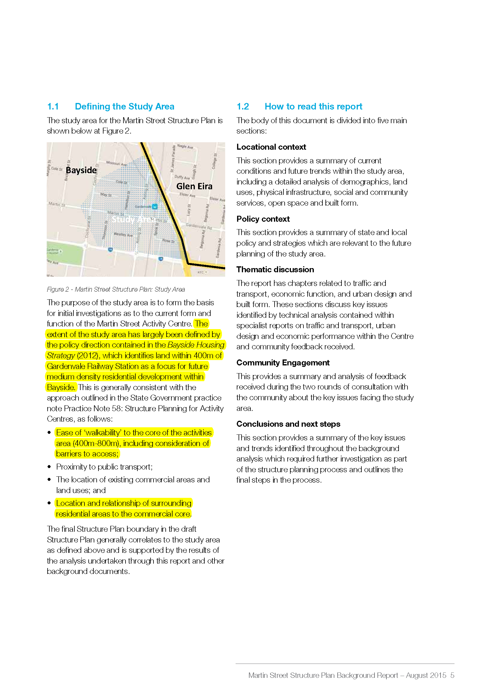
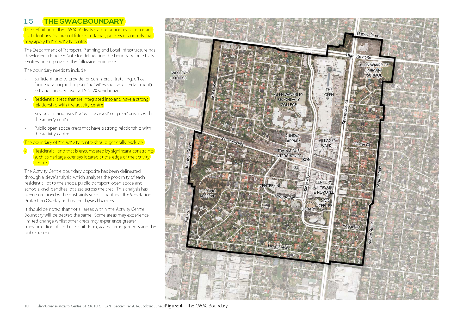
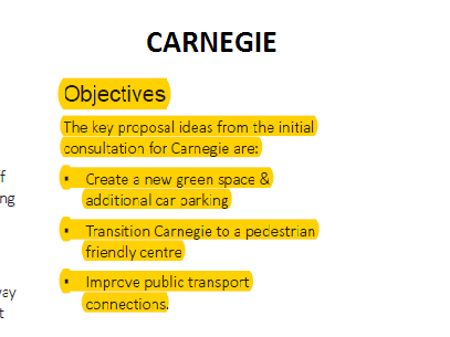
The 3 images above depict an aspect of structure planning undertaken by different councils – and stand in stark contrast to how Glen Eira Council is approaching the same task.

Please note that:

  • Each of these councils includes vast areas of ‘residential’ land
  • Borders are clearly defined and are ‘reviewed’
  • Notations that ‘heritage’ areas to be ‘generally excluded’

Glen Eira’s structure planning concentrates exclusively on the main shopping strip (ie Centre Road, Glen Huntly Road, etc) and the surrounding residential areas (ie the zones) are ignored. The use of the term ‘shopping strip’ alone in the surveys was the clear giveaway!

Given that ‘structure planning’ is meant to deal with ‘activity centres’ as a whole, and that activity centres include far more than a single shopping strip, we find the approach taken by council far from adequate – especially in light of the countless comments already submitted by residents complaining about overdevelopment in their side streets. What we are therefore seeing is NOT a structure plan for an activity centre but a half baked approach to genuine community consultation and proficient strategic planning.

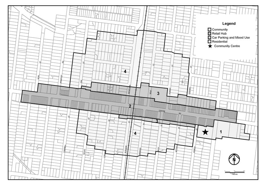
Finally, Council’s planning scheme clearly outlines what it considers to be an activity centre. Here is the one for Bentleigh –

By ignoring the residential areas included in the activity centre, we can only wonder at the efficacy of any resulting structure plan. If no current data on population, car ownership, developments, etc is included in the design of any future structure plan, then the very validity of the plan must be questioned. As shown in previous posts the vast majority of development is not occurring in the areas zoned Commercial, but in the abutting residential areas. The impact of this must be reviewed and questions as to capacity, infrastructure needs, etc. addressed before any window dressing occurs for the central shopping strips alone.

Residents do have cause for concern given the ‘results’ which have thus far been produced by council in regard to the structure planning ‘consultations’. The plans are supposedly based on community feedback. Yet very little of what residents wrote is reflected in any of these documents. When even council is forced to admit that ‘opposition’ to ‘private development’ features prominently in most of the areas listed, but fails to make an appearance in the ‘objectives’ section listed for further action, then something is drastically wrong.

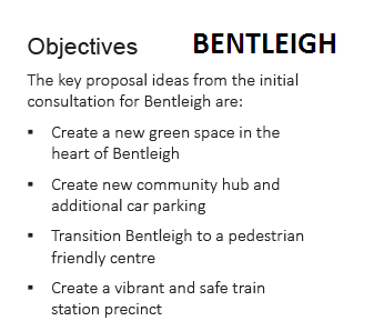
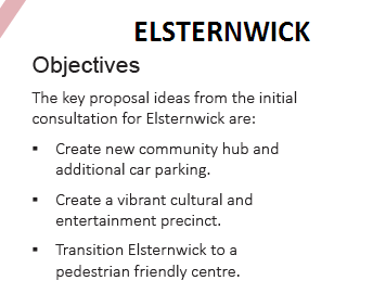
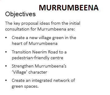
Below is what council sees as the road map for the next phase of ‘consultation’ for four of the designated activity centres – (the screen dumps come from the ‘Transformational Concepts’ report). Please keep in mind that no explanation has been given why Hughesdale and Murrumbeena should be included as part of the first cabs off the rank instead of say Ormond, McKinnon and even Balaclava, Glen Huntly and Caulfield which according to the latest version of Plan Melbourne are now designated as MAJOR ACTIVITY CENTRES!

What we have here is thus another example of a Clayton’s Consultation where decisions have already been made and the ‘results’ of  community input are deliberately distorted, or completely ignored!

Many residents, it seems, are pinning their hopes on the approval of council’s interim height amendments C147 and C148 for the Bentleigh and Carnegie ‘urban villages’. We remind readers that in both of these draft amendments, council saw fit to request, for the most part, only a ‘preferred’ height limit for the commercial and mixed use zones. Bentleigh was to have a preferred 5 storey height limit and Carnegie a preferred 7 storey limit.

At the time many residents asked for mandatory height limits for the entire areas. Council in its wisdom argued that their chances of ‘success’ depended on not asking for too much, so that leaving the majority of land as ‘preferred’ was the best option. Mind, no ‘consultation’ has ever taken place as to whether or not residents felt that 7 and 5 storeys were appropriate or even if 13.5m and 10.5m were appropriate height limits for massive areas of the municipality!

Needless to say, no strategic justification was submitted with these draft amendments and residents were certainly never provided with any such justification. Hence, in part at least, the minister’s delay in rubber stamping anything. The question now becomes, will these amendments solve the problems of overdevelopment? How confident should residents be that a ‘preferred’ maximum height of 7 or 5 storeys will be the magic bullet that curbs developer greed and abuse of the planning system?

In order to answer this question we have perused some VCAT decisions from the past year. They certainly do not fill us with confidence that the option of going for ‘preferred’ height limits will halt buildings in excess of these heights. Below we feature some verbatim quotes from various VCAT decisions where the developers were successful in gaining permits in excess of what the various planning schemes stated as their ‘preferred’ height limits.We quote verbatim:

The starting point for a consideration of the overall height and setbacks of a proposal is the overlay. The discretion to vary the preferred heights and setbacks is appropriately informed by a wide range of factors, including but not limited to those which are contained within the decision guidelines of the overlay. The strategic and physical context of the site will be important considerations when deciding whether to exercise the available discretion, as will the design of the building. The proposal should not be rejected simply because it does not comply with the preferences expressed in the overlay. Not all sites within DDO18 in this location will be capable of achieving the preferred height and not every site will be limited to this height

Source: http://www.austlii.edu.au/au/cases/vic/VCAT/2016/2104.html

It (the application) provides for a form that is in the general height range sought. It is not substantially over the preferred height listed in the table, and we accept that had the proposal been for a seven storey commercial building, its absolute height would not be dissimilar to that proposed for a nine storey, predominantly residential building.

Source: http://www.austlii.edu.au/au/cases/vic/VCAT/2016/2044.html

While the preferred height limits are relevant, they are but one factor in my assessment of the appropriateness of the proposed height for the review site. Another important factor is context, and another still is the quality of the overall design response proposed for the review site.

Source: http://www.austlii.edu.au/au/cases/vic/VCAT/2016/1833.html.

  • The proposed building has a maximum height of 16.5 m, exceeding the preferred height by 2 m. The proposed building is 5 storeys high, one storey higher than the maximum height which appears to be contemplated by the design guidelines. Council and respondents submit that these provisions establish a height limit which should not be exceeded and which when exceeded results in a building which fails to appropriately respect the preferred character within the precinct.
  • I do not think that this is the correct approach to the analysis of the policy framework in respect of this precinct. This approach treats the precinct as a uniform whole and fails to have sufficient regard to fails the diverse factors which influence which should be regarded as an appropriate outcome within different parts of the precinct. These factors include:
  • Some parts of the precinct are very close to the Camberwell Junction Activity Centre, they are as Mr Bissett submitted, within the sphere of influence of the activity centre if not being part of it.
  • I consider that this level of change is not a matter of concern, because it is consistent with the level of change which is anticipated by the zone provisions and the broader planning policy framework as it relates to important activity centres. It is reasonable to expect that the character of the eastern end of Precinct 49 will be transformed over time.
  • In general terms I consider that land within Precinct 49 east of Hastings Street is at least within the sphere of influence of the Camberwell Junction Activity Centre. This factor, together with the association of the land with land in the Commercial 1 Zone and the General Residential Zone lead me to the conclusion that, on suitable sites, buildings in excess of 4 storeys in height may be appropriate, provided that the interfaces with adjoining land are appropriately managed.

Source: http://www.austlii.edu.au/au/cases/vic/VCAT/2016/1477.html

On balance, I am not persuaded that the extra height of a building that exceeds the proposed mandatory controls by between 1.2 and 2.2 metres will be discernible to a viewer at street level or that it sets a precedent for other buildings that may exceed Council’s desire for a 19 metre height limit. One of the major benefits of a discretionary control is that it allows for some variation around a preferred height depending on the particular site context. I consider that allowing a building to slightly exceed 19 metres does not undermine or offend any of the relevant design objectives proposed in DDO18.

Source: http://www.austlii.edu.au/au/cases/vic/VCAT/2016/1088.html

SHOULD THE PREFERRED HEIGHT NOMINATED IN THE PROPOSED DESIGN AND DEVELOPMENT OVERLAY BE IMPOSED?

  1. Schedule 19 to the Design and Development Overlay, titled Brunswick Activity Centre – Lygon Street Local Area applies to the site and surrounds. It envisages a five-storey spine (17 metres maximum) along the western side of Lygon Street transitioning through four-storey development (14 metres) along the eastern end of Pitt Street to the area’s residential hinterland further to the east.
  2. The review site is the closest of the ‘four-storey development sites’ to the spine. Due to the strategic decision to apply the spine to existing titles facing Lygon Street, land immediately to the north[2], south and east of the site is earmarked for five-storey development.
  3. Consequently, the Applicants’ say it is reasonable to propose a five level building here, as it will have a comfortable relationship with surrounding buildings. They see a planning detriment in restricting its height. Losing a floor means three less dwellings in a location earmarked for high density residential development.
  4. The Council contests this interpretation. It says that ‘double-dipping’ into the planning policy framework misinterprets the Brunswick Structure Plan. It says that all relevant State and local planning policies were factored into the Brunswick Structure Plan. It says the preferred maximum heights of the Overlay reflect the policy framework holistically.
  5. Further to this, it says the word ‘maximum’, when referring to preferred ‘maximum’ heights in this and similar Overlays, should be afforded its ordinary English meaning. It says it should not be presumed that each and every surrounding development will reach its maximum height. As such, predictions of this site’s future physical context should not presume that five-storey development will occur to the site’s north and east[
  6. Finally, it submits that I should be cautious of promoting incremental ‘cribbing’ of heights. It asks me to acknowledge that an approved building that is one-storey higher than the Overlay’s preferred maximum will be used as ‘leverage’ to justify something taller than the preferred maximum on nearby lots.
  7. These general submissions do not persuade me. The question, when properly put, is whether a proposal responds to its planning and physical context. In other words, direction provided by planning policy and opportunities/constraints resulting from its siting amongst its neighbours must be integrated to provide an acceptable outcome. This is the basis of a performance-based system where every proposal is decided on its merits. In this instance, I find the opportunities resulting from its siting amongst its neighbours allow a five-level building to meet the Structure Plan’s objectives for this location.
  8. I attach little weight to the submission regarding ‘double-dipping’ in this instance. Allowing an extra floor of three dwellings will barely alter the Brunswick Structure Plans outcomes. Further to this, I find the submission is contrary to the generally accepted principle that each proposal should be considered on its merits with due regard for its physical and policy context. I find it reasonable to conclude that the strategic drafting decision to link title boundaries to preferred heights leaves some leeway for variations to the preferred maximum heights.

Source: http://www.austlii.edu.au/au/cases/vic/VCAT/2016/254.html

« Previous Page — Next Page »