GE Governance


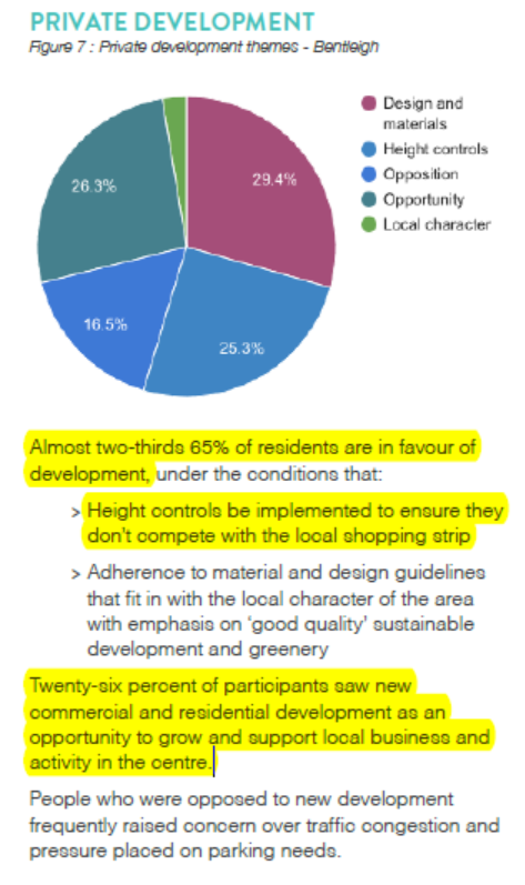
A huge gulf exists between resident responses to the ‘surveys’ on ‘transforming’ our activity centres, and what is portrayed as the ‘results’ of this ‘consultation’. The McKinnon report is another example of a work of fiction that fails to accurately represent what residents said – especially in the category of ‘private development’. Here is the pie chart claiming to depict the results –

Please note the following:

  • To claim that ‘there was no clear agreement on suitable building heights’ is rather rich given that residents have never been asked – what do you think is an appropriate development height in any of the activity centres!
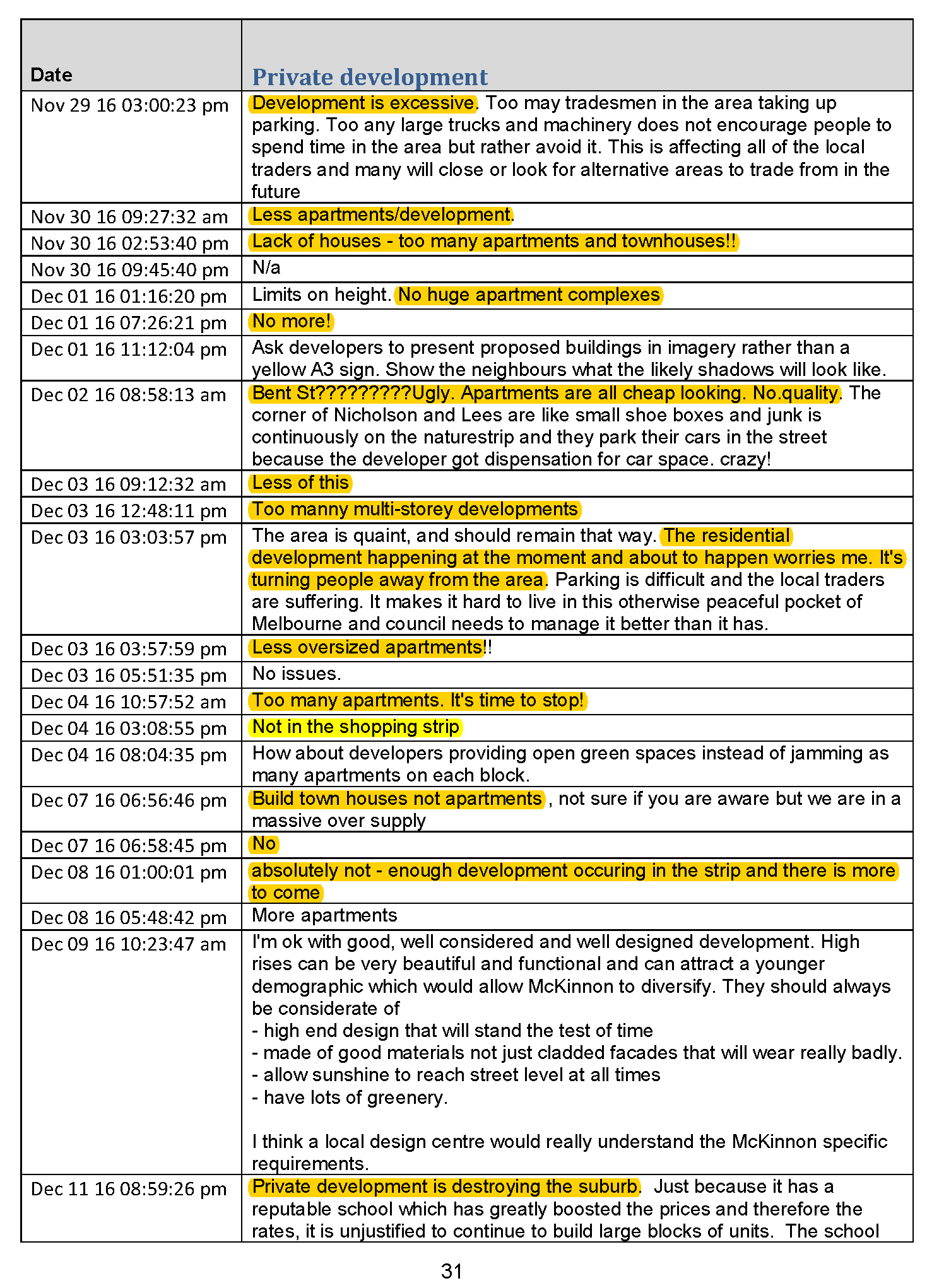
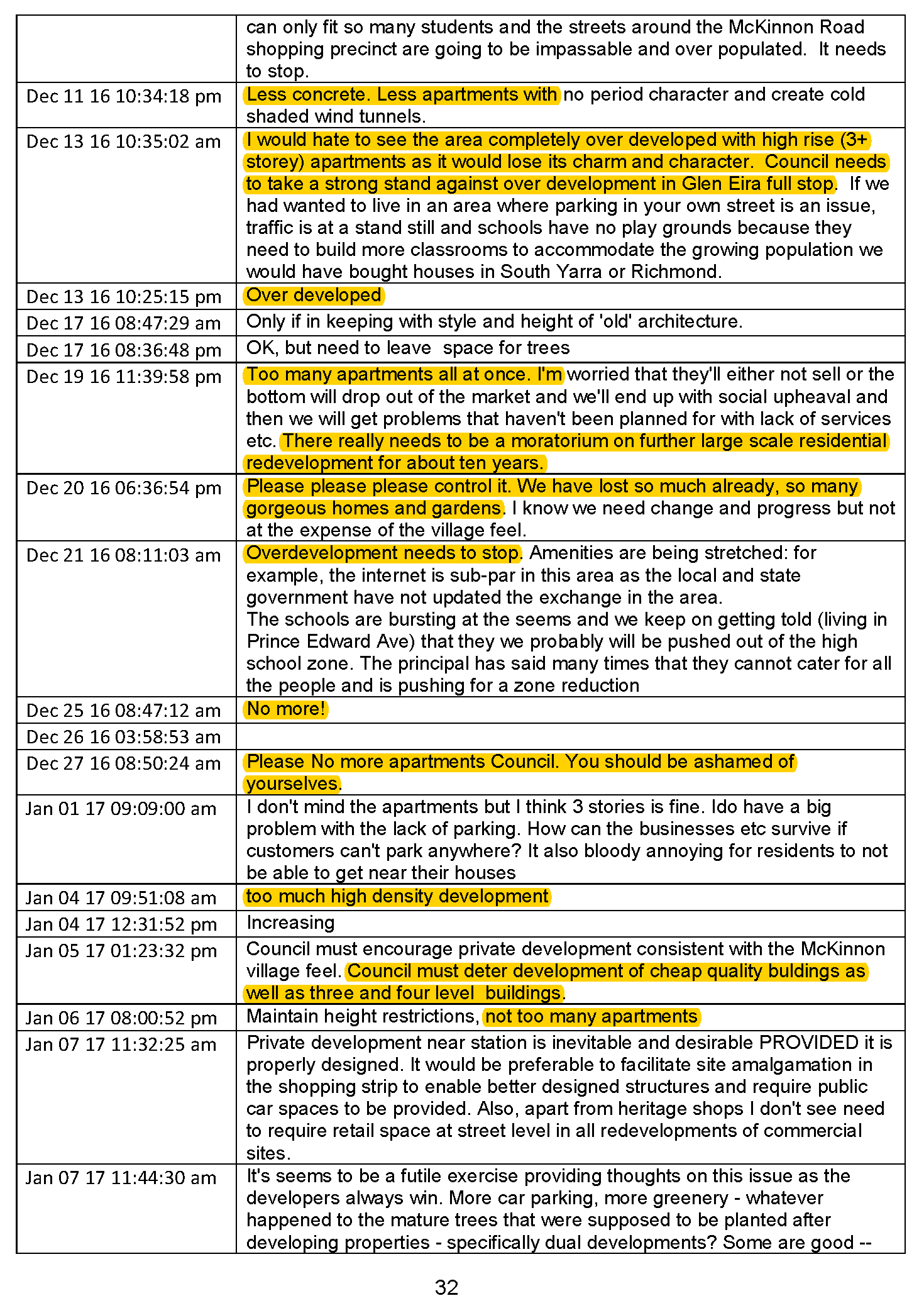
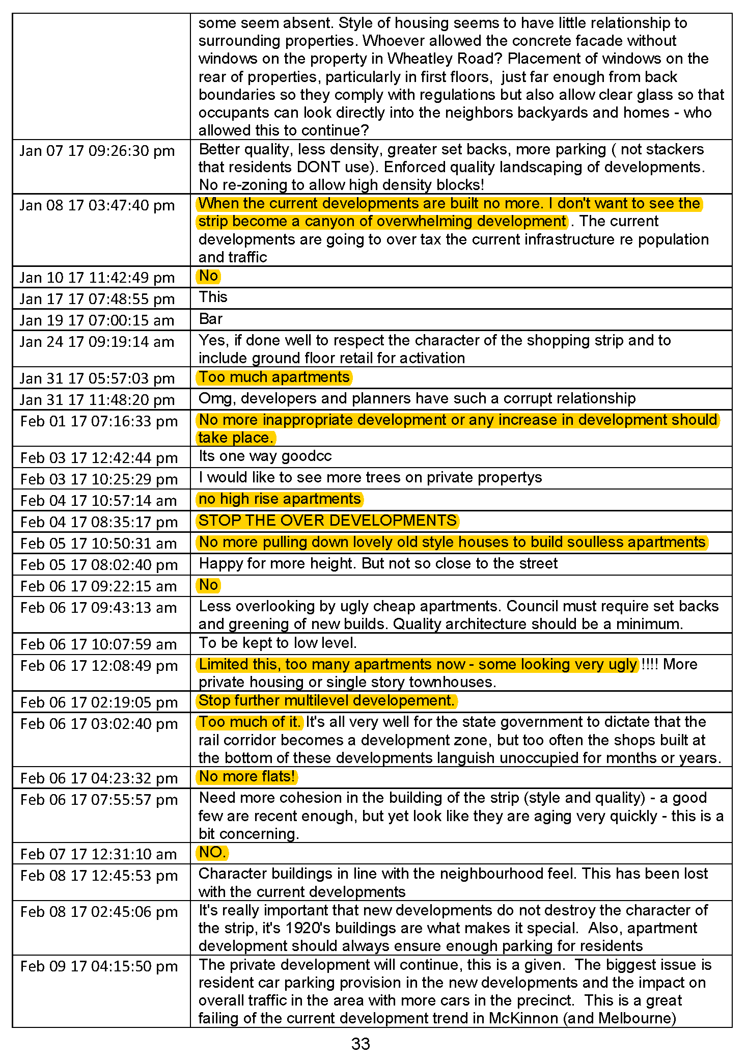
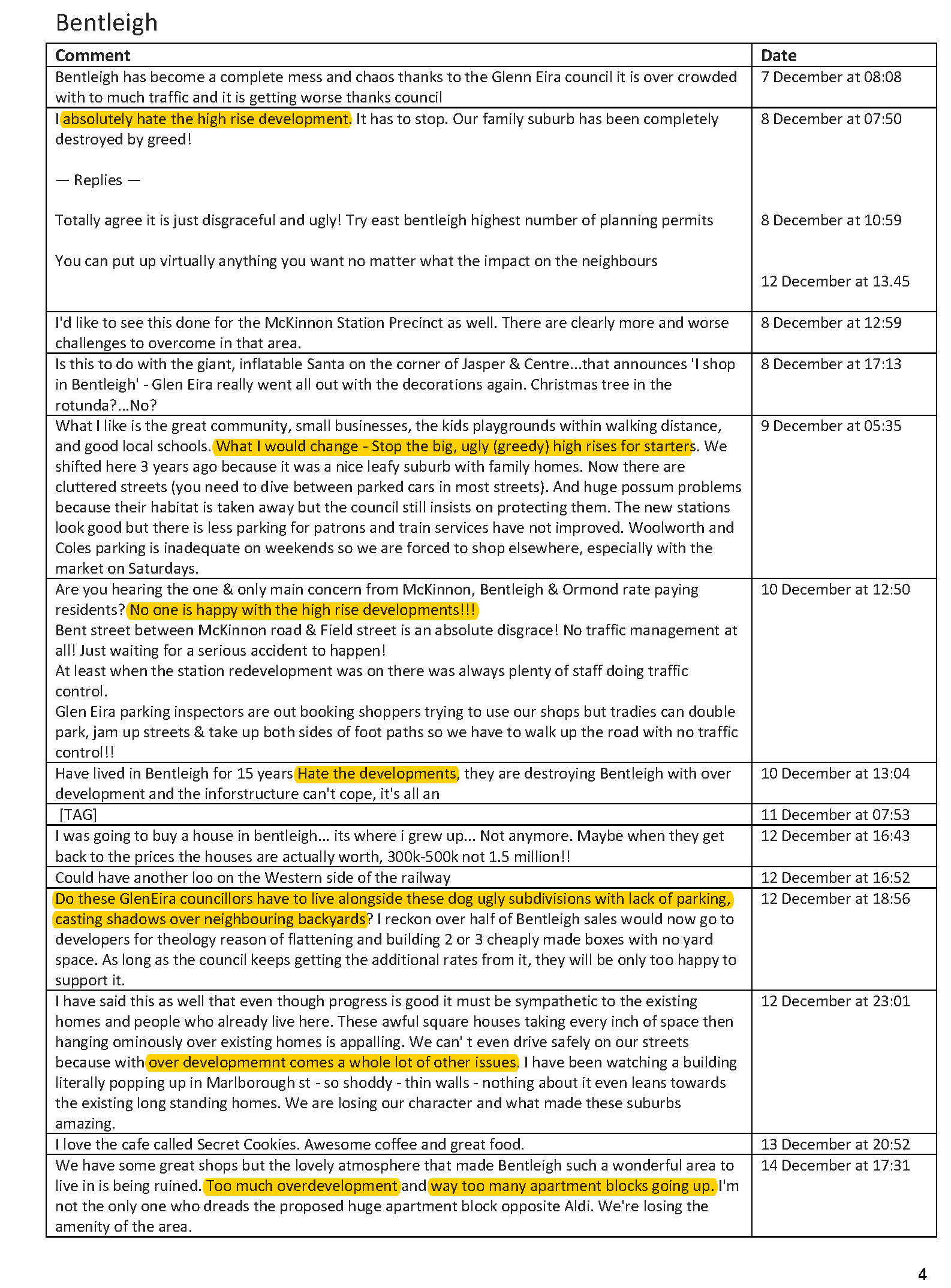
  • The claim that only 27.8% of comments were opposed to development is utter nonsense. On this topic of ‘private development’ there were 64 valid responses. We’ve ignored blanks and those marked as n/a. Of these 64 responses, a clear 39 were opposed to development (highlighted in orange below). That makes it 60.93% of responses were opposed to development
  • The report also states that ‘Many felt it was the popularity of the suburb services, particularly the high school’ that resulted in ‘increased population’. A more honest response could have been that increased population is a result of the zoning. Further, of the 64 comments only 3 mention schools at all – that is 4.68% – yet it rates a prominent mention in the report!

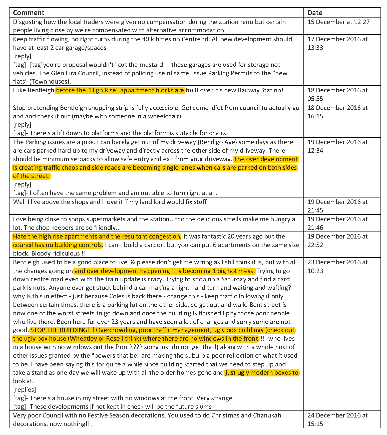
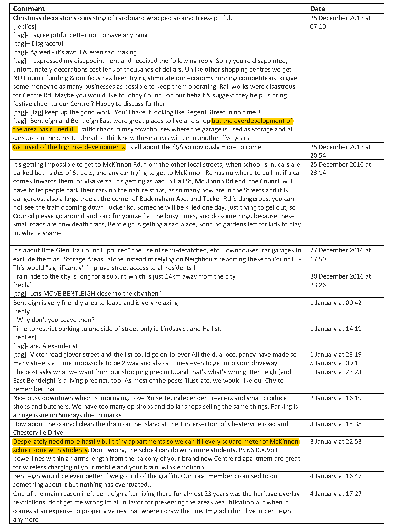
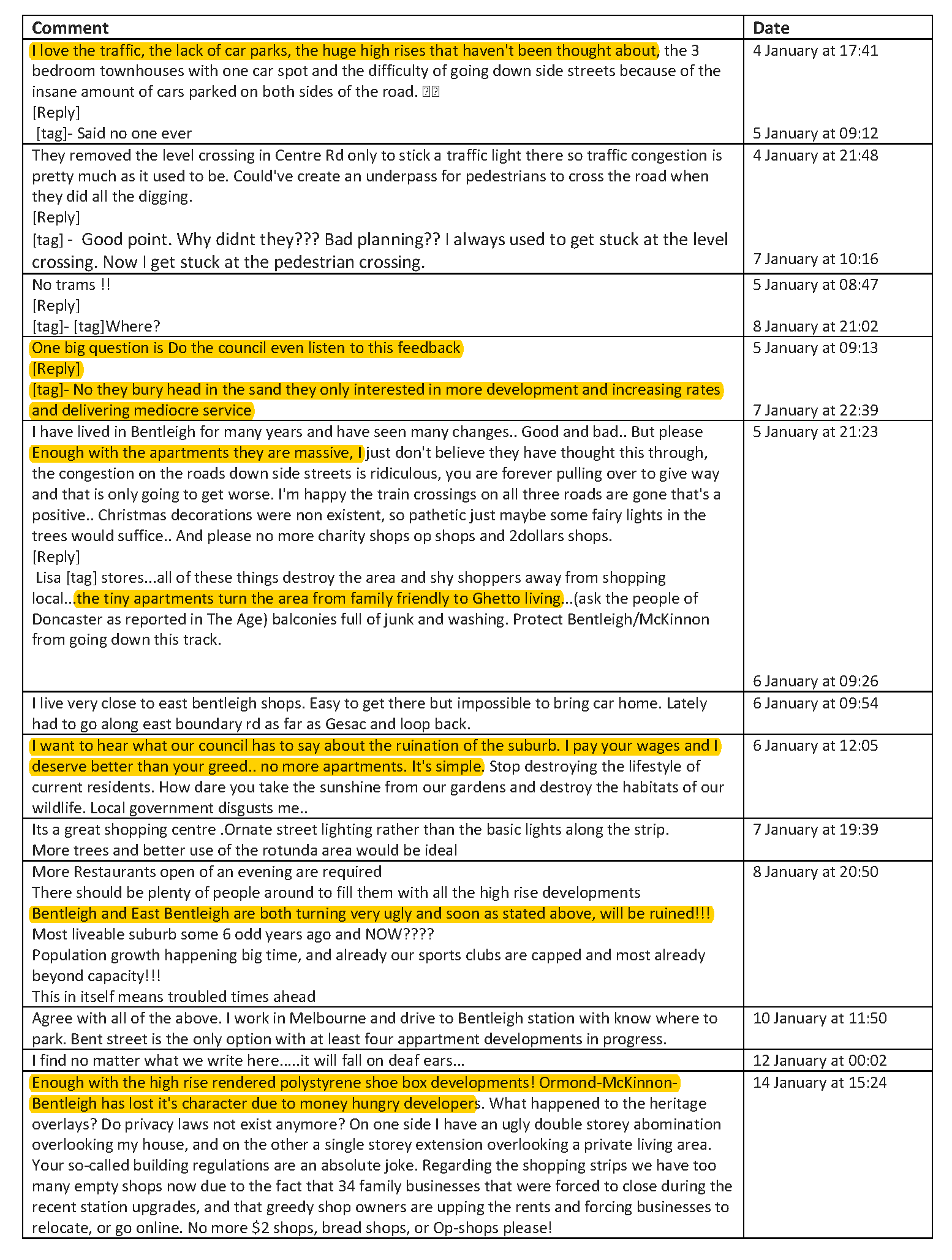
Please read the following comments and judge for yourselves as to the validity, honesty, and accuracy of this ‘consultation’ report.

The current agenda features 3 items of particular interest. Two involve planning applications and the third is an officer’s response to a request for data on car parking waivers as a potential tool to use at VCAT. What is presented in each of these reports we find staggering and wonder what on earth is going on with planning in this council.

  1. Data on Car Parking Waivers

As per usual, the report  concludes that – It is considered that the extensive resources required to collate car parking waiver data could be more effectively directed towards creating the strategic basis for future car parking provisions. By doing so, much needed clarity can be provided to the town planning process in Glen Eira with subsequent benefits in defending VCAT appeals.

Backing up the ‘do nothing approach’ we get – A comprehensive audit of past planning decisions to obtain car parking waiver data would be a resource intensive exercise.

The ultimate recommendation therefore reads – That Council acknowledges this report and the strategic work that is underway which will ultimately lead to clearer and more effective planning provisions around car parking.

We also urge readers to note the following paragraph – In terms of specific controls,Council’s adopted Planning Scheme Review Workplan is committed to investigating the use of Car Parking Overlays and Parking Precinct Plans. These controls can provide greater clarity for decision makers, the community, and permit applicants through location specific car parking rates or developer contributions.

COMMENT

  • Resident comments on the planning scheme review were strongly in favour of developer contributions. Here we find ‘or developer contributions’ and this is the only time in the entire report that this issue rates a mention. Question: does council really have any intention of introducing a levy for car parking waivers? Given that the emphases is entirely on overlays and Parking Precinct Plans, which were promised in 2003/4 – our skepticism is probably warranted!
  • More of the same from this council? – ie let’s not do anything for the moment until our structure plans are in place! We do not see how the collation of empirical data should impact the ongoing development of structure planning. We would also assume that such data should be available on council’s computer systems. If it isn’t then why not? – especially when millions upon millions are spent on council’s systems. Surely it is time that some decent programming was undertaken so that all data pertaining to an issue is there at the click of a button?

 The Planning Applications

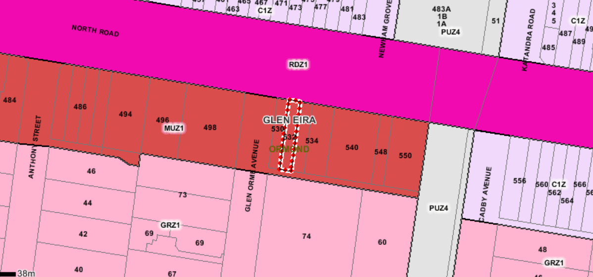
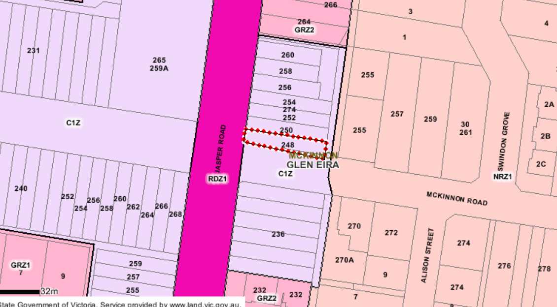
Below are two screen dumps that show the zoning for the applications. One in North Road, Ormond (5 storeys, 4 units) and one in Jasper Road, McKinnon (4 storeys, 4 units). Worth noting that council hasn’t used zoning maps, but instead included aerial shots which (perhaps intentionally) do not show up the planning contexts of these sites. Before proceeding further, readers might like to hazard a guess as to which application was refused and which was granted a permit?
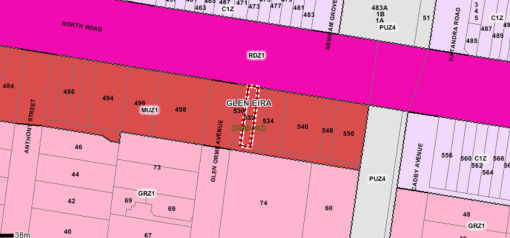
  1. North Road Application

The officer’s recommendation was refusal. Yet scattered throughout the report we find the following:

  • The waiving of one visitor car spot was fine since – given the site’s proximity to Glen Orme Ave there would be ample on street car spaces for the one visitor car space shortfall
  • It is considered that the proposed development complies with Council’s Housing Diversity Area Policy. The height, density, mass and scale of the development is considered appropriate for this location.
  • The height and scale of the proposal are in keeping with the emerging character of the areaencouraged by State and Local Policy.The proposal has a maximum height of 16.7 metres. This is comparable to the approved development under construction next door at 534-538 North Road which also has a height of 16.7 metres.
  • On overshadowing – Whilst there will be overshadowing created by the proposal it is not considered to have any unreasonable impact on any adjoining land given the mixed use zoning to the east and west and the non-residential use immediately to the rear.
  • Internal amenity is deemed satisfactory

Thus on all the major ‘criteria’ this proposal meets the requirements. The refusal boils down to laneway access and car stackers and that the plans have not ‘satisfactorily demonstrated’ that access and layout provide a ‘safe environment for users’. So we now have the situation where an application for 5 storeys in a Mixed Use Zone and surrounded by GRZ, and other commercial sites that are already 5 storeys is refused on grounds that we doubt will stand up at VCAT. Besides, council already thinks that 8 storeys is appropriate for the Ormond Tower!

  1. Jasper Road Application

This application gets the nod of approval – despite the fact that it directly abuts a Neighbourhood Residential Zone; no onsite parking is proposed for the food outlet, and no visitor car parking for the 4 units (ie the magical number is 5!). We then get these extraordinary components –

  • Transport planning is against waiving of the car parking spot for the food outlet but in the end it is considered ‘acceptable’ to waive the requirement because of the ‘availability of public transport’, and ‘onsite car parking’. Isn’t North Road also close to public transport?
  • Internal amenity is only ‘generally appropriate’ and this can be fixed by a condition requiring a window or a skylight
  • The laneway of 3.5 metres is considered to be a ‘sufficient buffer’ to the NRZ residents
  • Car stacker is ‘generally satisfactory’ but more detail is required! (Note the contrast of this to the North Road application!)

CONCLUSIONS?

  • How about some consistency?
  • How about providing the full facts – ie width of laneway in North Road application?

Finally, just to add salt to the wounds,  the hole in the ground opposite the Jasper road application was originally granted a permit for 4 storeys in 2014 by council. The land and permit were then on-sold and we now have another application for –

The construction of a five storey, mixed use building above basement car park (comprising a food and drink premises and 45 dwellings); a reduction of car parking requirements; waiver of loading bay requirements; alteration of access to a Road Zone Category 1; construction of buildings and works within a Special Building Overlay

What does this all this say about council considering ‘cumulative impact’ on street car parking spaces and on the overall approach to providing transparent and credible officer reports?

Booran Reserve playground in Glen Huntly could be best in Melbourne

Bianca Carmona, Caulfield Glen Eira Leader

April 1, 2017 12:00am

A CHILD’S smile might be priceless to most, but it comes with a hefty price tag of almost $11 million in Glen Eira.

The council has spent $10.8 million creating what could be Melbourne’s most expensive playground at Glen Huntly’s Booran Reserve.

It is almost twice the cost of the Royal Park Nature Play Playground next to the Royal Children’s Hospital, which opened two years ago and is considered one of Melbourne’s best.

By comparison, neighbouring Bayside Council has approved funding of almost the same amount ($10.48 million) to improve more than 60 play areas over the next 10 years.Booran Reserve in Glenhuntly will open soon.

The Leader asked Glen Eira council what bang ratepayers were getting for their buck, but the council refused to reveal a breakdown of the final bill, acknowledging only that the State Government had provided $700,000.

Leader can reveal the water-themed playground of the future boasts Australia’s first double-dome climbing net, custom-made play equipment, a water play area, outdoor gallery space, urban forest corridor and double flying fox.

Glen Eira Council infrastructure, environment and leisure director Samantha Krull said the reserve, which was formerly a reservoir, included a range of spaces that provided for play, activity and relaxation.

The construction of the playground at the corner of Glenhuntly Rd and Booran Rd is now almost five months behind schedule, building anticipation about its opening on Sunday.

Comments from the Glen Eira Residents Action Group were mostly positive, with member Vicki Howson writing: “Wow, looks fabulous … can’t wait to take my grandchildren here.”

But Ratepayers Victoria vice-president Jack Davis wasn’t impressed, saying the price tag was “ridiculous”.

“It’s an exorbitant use of ratepayers’ funds,” he said.

A Community Fun Day will be held at the reserve on Sunday, April 9.

The official opening will be held on Tuesday, April 11, by Victorian Minister for Innovation Philip Dalidakis.

Source: http://www.heraldsun.com.au/leader/inner-south/booran-reserve-playground-in-glen-huntly-could-be-best-in-melbourne/news-story/f132e57ea7cb7b1b7ebba5ca420d6230

Residents do have cause for concern given the ‘results’ which have thus far been produced by council in regard to the structure planning ‘consultations’. The plans are supposedly based on community feedback. Yet very little of what residents wrote is reflected in any of these documents. When even council is forced to admit that ‘opposition’ to ‘private development’ features prominently in most of the areas listed, but fails to make an appearance in the ‘objectives’ section listed for further action, then something is drastically wrong.

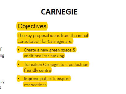
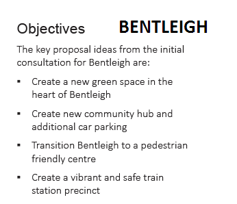
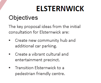
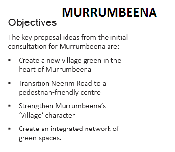
Below is what council sees as the road map for the next phase of ‘consultation’ for four of the designated activity centres – (the screen dumps come from the ‘Transformational Concepts’ report). Please keep in mind that no explanation has been given why Hughesdale and Murrumbeena should be included as part of the first cabs off the rank instead of say Ormond, McKinnon and even Balaclava, Glen Huntly and Caulfield which according to the latest version of Plan Melbourne are now designated as MAJOR ACTIVITY CENTRES!

What we have here is thus another example of a Clayton’s Consultation where decisions have already been made and the ‘results’ of  community input are deliberately distorted, or completely ignored!

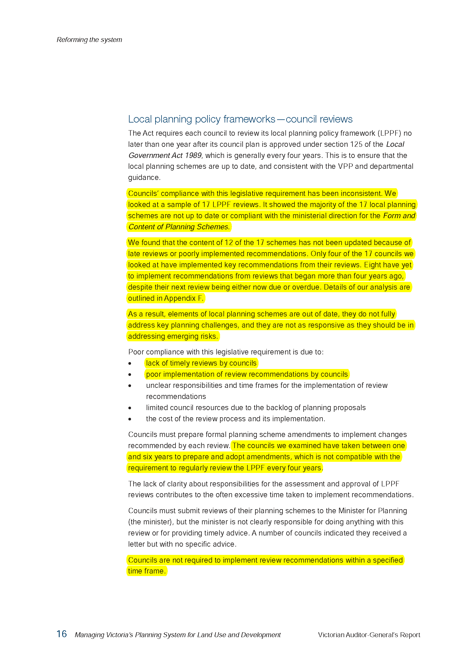
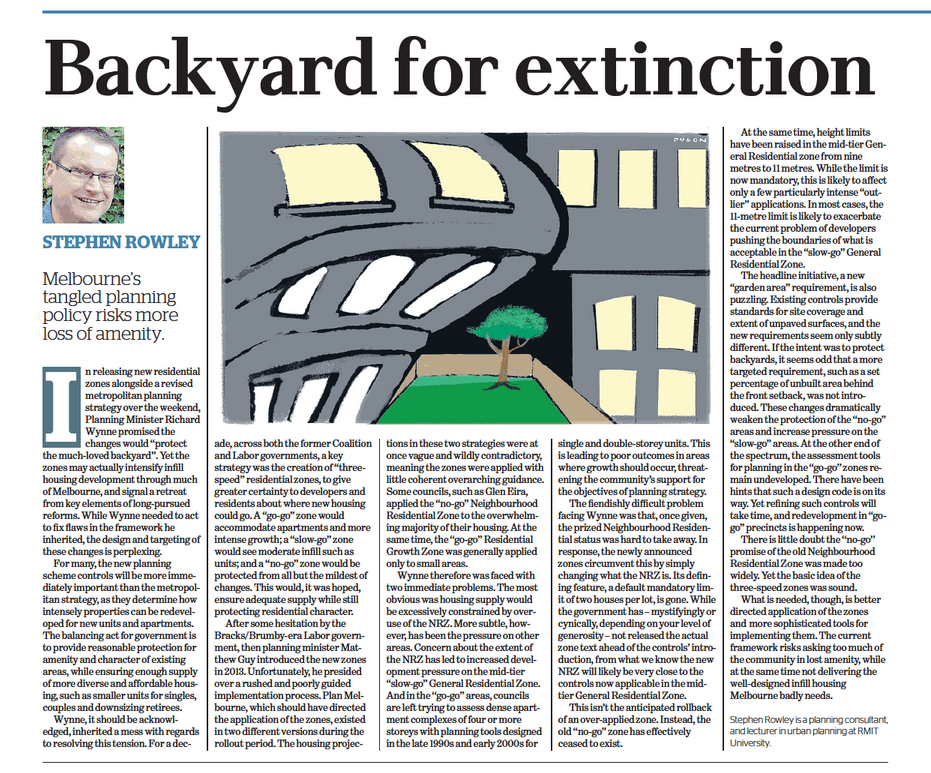
In the most scathing terms possible, and with conclusions that reveal the mess that State and Local planning authorities are in, the Auditor General released a report yesterday that basically found:

  • The Department is not doing its job
  • Ministers, department, and councils lack transparency and accountability
  • The legislation is inadequate and contradictory

It is a comprehensive review of planning in the state and well worth a read for those interested. Some of the most interesting points made emphasise that very few amendments or planning permits adhere to the ‘social, environmental, and economic’ ‘net benefit’ for the community that the legislation requires. In most cases, these elements don’t even get a mention in reported decisions. Here are some quotes, which we believe apply most strongly to Glen Eira City Council:

If the community is to have confidence and trust in the planning system, decisions must be transparent, and planning schemes must be well implemented and operate as intended.

The assessments DELWP and councils provide to inform decisions are not as comprehensive as required by the Act and the VPP. DELWP and councils have also not measured the success of the system’s contribution to achieving planning policy objectives.

Transparent—there is generally strong community participation due to extensive third-party and appeal rights in planning decisions. However, planning assessments used to inform decisions do not transparently analyse all relevant planning matters as required by the Act and the VPP, and not all decisions are accompanied by published reasons.

Some councils are also slow to review and revise local planning schemes, and there is no requirement for DELWP to regularly review and revise the content of the VPP.

The following image sums up many of the issues that bedevil Glen Eira –

The full report can be found at – http://www.audit.vic.gov.au/reports_and_publications/latest_reports/2016-17/20170322-land-use.aspx

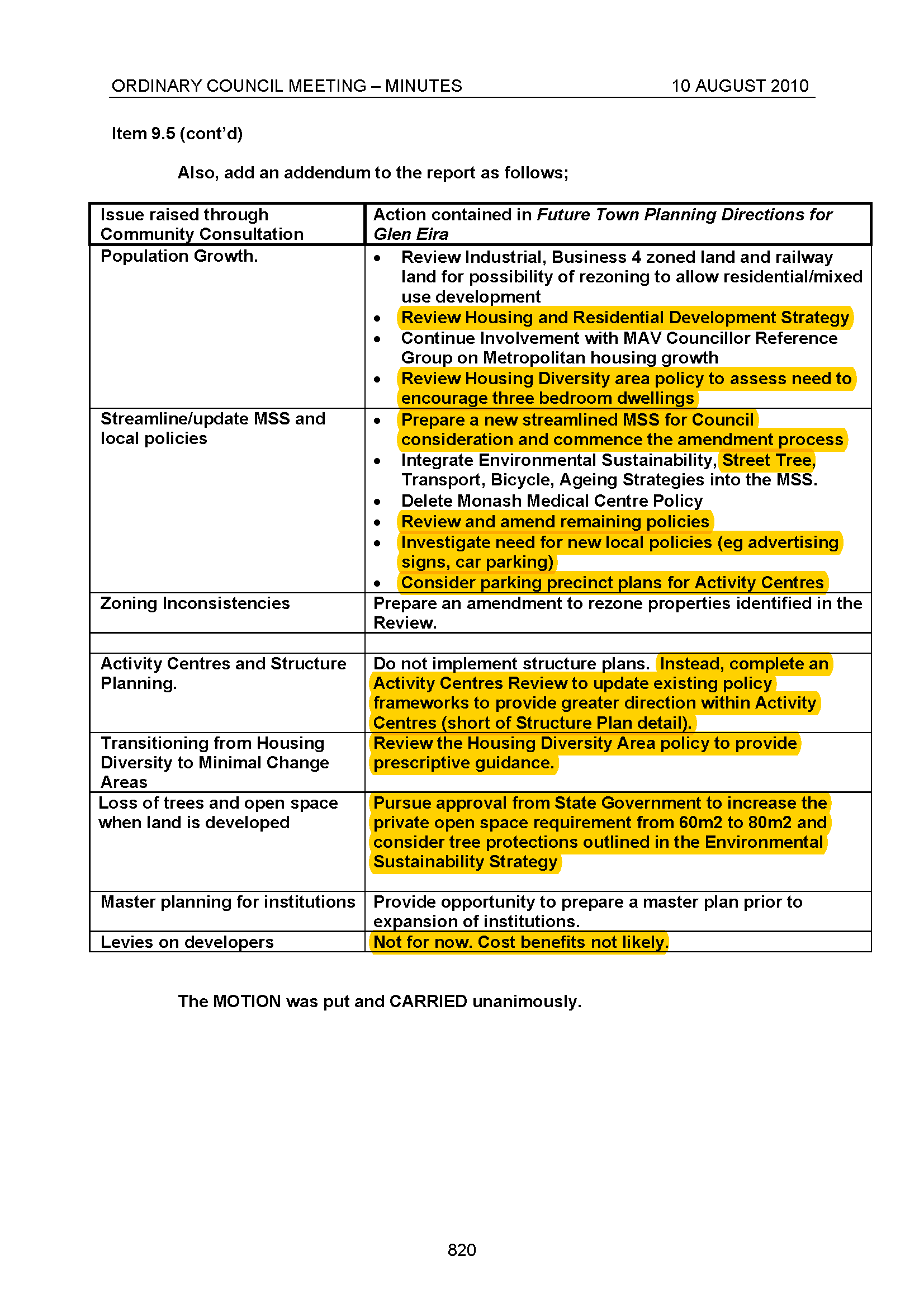
PS: just as a reminder of council’s failure to deliver on long made promises, we repeat part of a previous post that confirms everything the Auditor General claims. The image below comes from the minutes of 2010 and the (in)famous 2010 Planning Scheme Review. Please note all the promises that were made with none being delivered in the space of 7 years! Three councillors of that time are still on council – Esakoff, Hyams and Magee and Delahunty arrived in 2012. What have they done to ‘progress’ the initiatives of the review over this time span? The highlighted sections below speak for themselves.


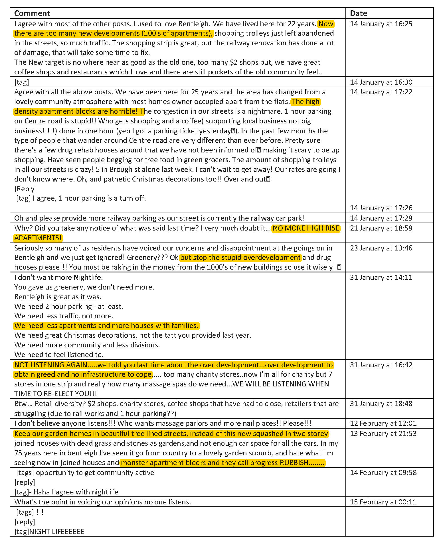
The image above comes from Council’s summary of community responses to the Bentleigh ‘shopping strip’ online survey. According to the ‘facts’ presented here we are meant to believe that 65% of respondents are in favour of ‘private development’ (whatever that means!) – but with some constraints on height and ‘character’. Please note that of the valid 248 comments included in the document, the claim that 65% are ‘supportive’ does indeed represent an entire work of fiction. What is most disappointing about this report is:

  • The failure to acknowledge the countless comments that specifically referred to overdevelopment in the various side streets of Bentleigh – ie the damage done via the zones
  • The exclusive emphases on the ‘survey’ comments rather than the opinions expressed via the forum PLUS the apparent ‘editing’ of the forum comments themselves – ie not every comment made online is included in the resulting ‘summary’. Here is one example of what’s been omitted – The critical and major issue is the urgent implementation of height and appropriate building form controls. Interim measures are required immediately to ensure a planned future for the shopping precinct. The inappropriate and unplanned overdevelopment must be stopped now to ensure that structure planning results in long term plan
  • The total inconsistency in the reporting across all suburbs. Surely a report on community responses to one issue should include identical categories in the respective pie charts?
  • Could this possibly be another example of ‘community consultation’ designed to ‘endorse’ the decisions that have already been made behind closed doors?

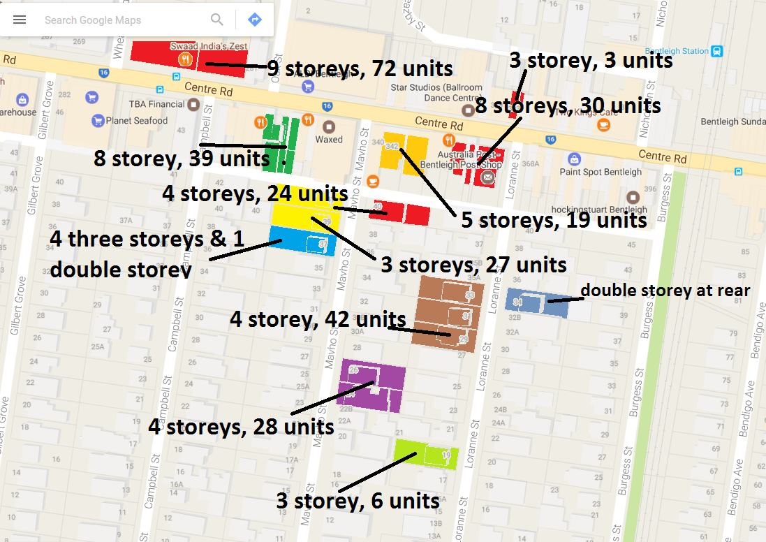
Presented below are the pages that are council’s version of the online forum comments plus another graphic displaying what has been happening south of Centre Road Bentleigh since the introduction of the zones!

Council’s recent release of documents related to its ‘structure planning’ must, in our view, be treated with a huge grain of salt. This is the first in a series of posts analysing what has been placed in front of residents and how valid, accurate, and transparent these documents really are. Are we again being taken for a ride via data that are highly questionable and manipulated to present already determined decisions?

The first document is called ‘Activity Centres Snapshot: February 2017’. It purports to be ‘based on similar studies carried out by Melbourne City Council’ in its Places for People and Local Liveability 2015 Study. (uploaded HERE). The aim is to ‘provide a more comprehensive understanding of how the city performs for everyday people’. Yet, when both of these documents are compared, the Glen Eira version is anything but ‘comprehensive’. For starters we are told that:

  • All data used in this document is current (February 2017) except for residential and employment population data, which is taken from the Census carried out by the Australian Bureau of Statistics in 2011. How much credence should then be placed on this ‘snapshot’, especially given the rate of development since 2011?
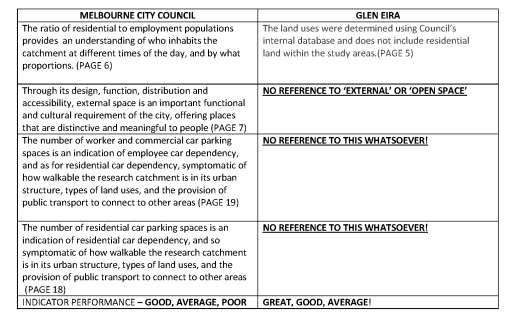
  • The land uses were determined using Council’s internal database and does not include residential land within the study areas. How on earth any study can ignore ‘residential’ is simply mind boggling! Or is this simply more confirmation of the fact that council is focusing exclusively on the single street shopping strips themselves and not the zones that have blighted countless people’s lives?
  • Then of course, there is this wonderful ‘escape clause’ – Disclaimer: this document is provided for information purposes and does not claim to be complete. Although due diligence has been applied to ensure that all information contained in this document is accurate, it cannot be guaranteed that this document is without errors or omissions. Why publish anything if its accuracy and integrity cannot be assured?

We’ve drawn up a table below which illustrates just some of the differences between the Glen Eira version of good planning and what the Melbourne City Council included in their study. To therefore claim that this piece of paper represents a ‘snapshot’ of what is happening in Glen Eira, and is the basis upon which to plan for the future, is not only ludicrous, but deliberately misleading and invalid.

MELBOURNE CITY COUNCI1

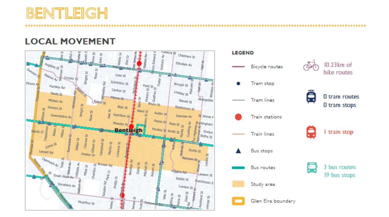
Compounding all of the above, we then have neat little maps of the various areas under consideration – with no explanation, no criteria, and again, lines drawn on a map. The City of Melbourne’s study clearly defined how its various neighbourhood borders were selected –

To understand the Local Liveability 2015 Study area at a local level, 5-minute walking catchments were identified across the study area to effectively act as a sieve and allow for disparate urban geographies and their components to be compared ‘apples for apples’. For greater rigour and to reflect the true local urban conditions, real 5-minute walking catchments were determined rather than standard ‘as-the-crow-flies’ walking radii.
Local Movement as defined by Melbourne then includes ‘Car Spaces Per Employment’, ‘Car Spaces Per Resident’, and the numbers of bus stops, tram stops, etc.  All Glen Eira includes are the latter. As mentioned previously parking does not figure at all. Instead we are presented with nice little maps, that may look ‘professional’ and pretty, but which don’t reveal very much when terms, borders, and important categories are omitted!
The Bentleigh snapshot is typical. Depicted is a huge area that is overwhelmingly ‘residential’ – which we’re told has been excluded. Thus, what knowledge and what kind of basis for future planning can be drawn from this effort? Finally, Melbourne has no qualms in pinpointing areas that are ‘poor’ in terms of ‘liveability’ for its neighbourhood areas. In Glen Eira of course, the category ‘poor’ simply does not exist – everything is ‘great’ or ‘good’!!!!!!!!!

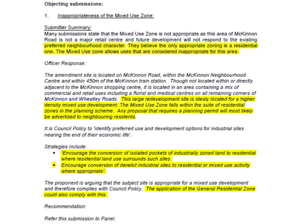
The image seen above comes from page 20 (of 424 pages!) from the current agenda. The Item concerns the controversial rezoning of the corner of McKinnon and Wheatley Roads to a Mixed Use zone with a 4 storey height limit. It is currently zoned Industrial 3 and hence not available for residential development.

We urge readers to carefully note the highlighted sections since:

  1. This is the first time in living memory that council has finally admitted that the Mixed Use Zone is classified as ‘residential’ according to its planning scheme! Previously all references to ‘residential areas’ have been cited as Neighbourhood Residential Zone, General Residential Zone and Residential Growth Zone only.
  2. Residents have objected on the basis that the land should be rezoned to GRZ in keeping with its proximity to surrounding residential properties. Whilst council admits that a GRZ rezoning ‘could also comply’, there is not one single sentence in the officer’s report which seeks to explain, much less justify, why this alternative zoning solution is not mentioned again or even considered. Given the real possibility that the ensuing planning application could include merely one shop or office, and 50 or so units, then we do not see that this will have any real impact on residential profits for the developer!
  3. The quoted planning scheme policies, also emphasise either ‘residential’ exclusively (ie grz) or, ‘residential or mixed use activity where appropriate’. Whether or not the proposed site is ‘derelict’ is of course another issue entirely.

Thus we have a situation where council has completely ignored 186 objectors (and 6 supporters) and instead of considering even the possibility of rezoning to GRZ or abandoning the amendment entirely, have recommended going to a panel. Given the location of this site surely a decent discussion of the most appropriate zoning needed to occur. Instead we get a recommendation that lacks transparency in our view, as well as justifiable validity.

PS: for an interesting comparison, we remind readers of a recent Amendment for North Road Ormond (C121) where the site was rezoned from Commercial 2 to Mixed Use Zone with its own special MUZ Schedule of NO.3. The height limit for this particular amendment  was a mandatory maximum of 10.5 metres! In McKinnon Road the proposed height is not merely 10.5, but 14 metres – well and truly above even the Residential Growth Zone stipulated heights! Thus, where there’s a will, there’s definitely a way! Here’s the North Rd site –

CLICK TO ENLARGE

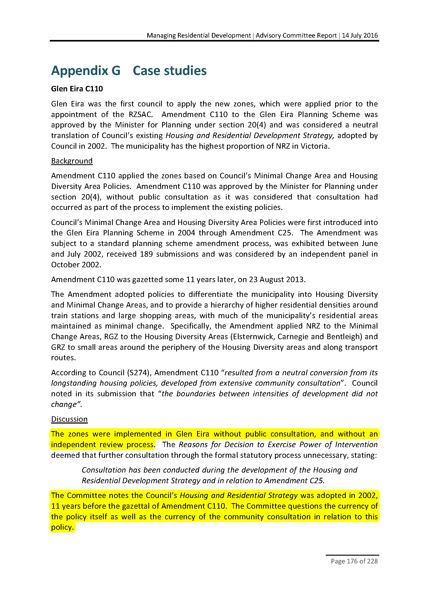
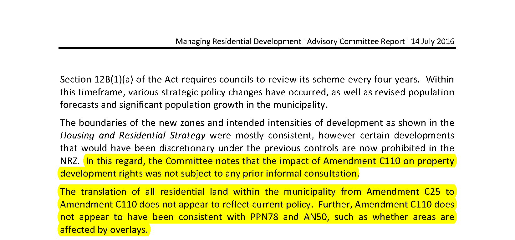
PS – FINALLY THE ‘SLAP ON THE WRIST’ TO COUNCIL FROM THE ADVISORY COMMITTEE REPORT

CLICK TO ENLARGE

For all the talk about ‘consultation’ the single thing that residents have been clamouring for over the past few years is being totally ignored – a review of the residential zones.

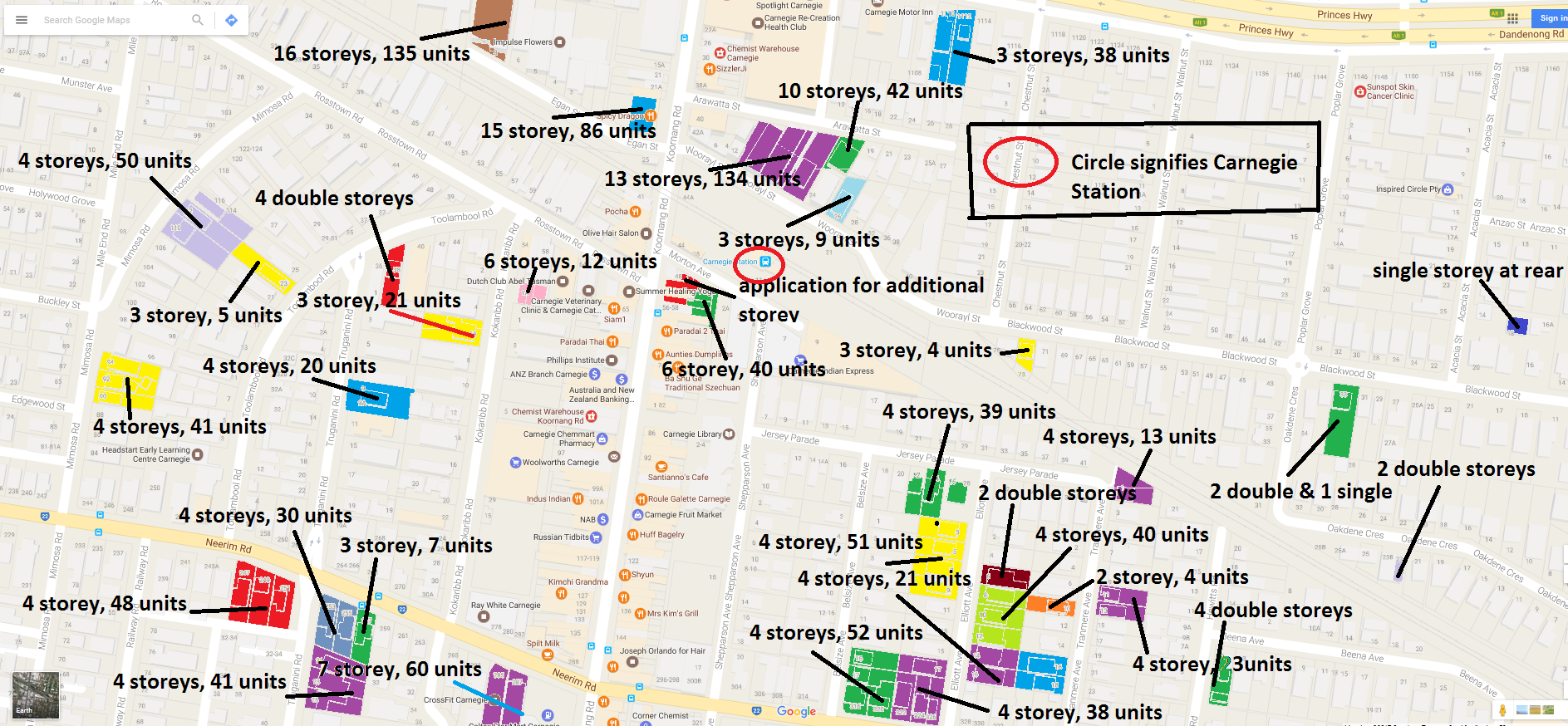
The image above provides clear, unassailable evidence of how disastrous the implementation and maintaining of the current zoning has been. Please note carefully:

  • The vast majority of development since the introduction of the new zones HAS NOT OCCURRED in those areas zoned as Commercial – which is what the planning scheme states should happen. Instead, street after street has been destroyed because it is zoned as suitable for 4 storey development.
  • Many of these streets are not within cooee of the railway station (circled in red) which is the reason for designating these areas as an ‘activity centre’. They might be 400-600 metres away from the station, but only as the crow flies. Walking distance (ie properties in Mimosa, Beena, etc) would make these sites at least one kilometre from any railway station.
  • Activity centres are also supposed to incorporate community facilities such as open space. The map reveals not a skerrick of nearby open space!
  • Other councils do their structure planning on the basis of recent Housing Strategies. Glen Eira’s fossilised strategy originates from 1998 data. Yet, we now have the spin about structure planning that will extend over the next 10 to 15 years, WITHOUT any new housing strategy!
  • Even Matthew Guy had enough sense in his July 2014 directive to mandate – A planning authority must use a housing strategy to inform the balanced application of the three residential zones. We assume that Guy’s order would presume recent analysis and data, since those councils who chose the option of going to a committee for the implementation of their zones were told that their proposed zoning couldn’t go ahead since their data is too old! Glen Eira as a result has no strategic justification for its implementation of the new zones according to what the committee told numerous other councils!
  • Guy even states – A planning authority must evaluate and monitor the implications of the application of any of the three residential zones within two years of their gazettal into a planning scheme. Planning authorities must specifically assess the affect of the residential zone(s) on housing supply, housing prices, infill development site land prices and the availability of land for infill development but are not limited to those matters. Three and a half years down the track and residents are yet to receive any decent ‘report’ as to the efficacy of all the zones – are they working? Where is development really going? What needs changing? How best to protect residential amenity?
  • Residents also should realise that when Amendment C25, which created the Housing Diversity/Minimal change areas in Glen Eira, the panel appointed to evaluate the amendment clearly saw this as an ‘interim’ measure. The word ‘interim’ was used over 20 times in their resulting panel report. Here is one example of what was stated – The boundaries of the neighbourhood centres identified in the amendment are considered by the panel as interim at best. Thus, we are stuck with ‘interim’ housing diversity borders and for the past 17 years no inclination by Council to do what it promised – ie review the areas and implement controls that will protect residents.

The take home message is that unless these councillors have the courage to admit that disastrous mistakes have been made, the rot will continue until the bottom falls out of the housing market. We simply ask:

  • Why can’t the borders of housing diversity areas be reduced given the fact that instead of the required 600 new dwellings per annum, Glen Eira is now accommodating over 2000 net new dwellings per annum?
  • Why should suburbs such as Ormond have over 40% of its area designated as suitable for 3 storey developments? – especially when large swathes are zoned as heritage?
  • Unless there is a comprehensive review of the zones, then residents have every right to label this council not only as incompetent, but negligent in its duty.
  • Creating structure plans only for the Commercial areas will not solve the problem of street after street being over-run with substandard dog boxes. This isn’t planning. It is cow-towing to the development industry and the refusal to admit that the Newton & Akehurst vision for Glen Eira is a total disaster, especially when residents have had no say in what happened!

As a reminder of the human cost involved, we re-publish an email we received a while back from an Elliott Street resident. It spells out everything that is wrong with planning in Glen Eira –

We live in the house next to the 51 units, 4 storeys, 3-9 Elliott Ave. It is on our north side! We will also be opposite 60 more units in Elliott Ave. Only 6 out of 20 houses left in our part of this small suburban street…… what can we say. We explored all avenues including going to VCAT, employing a Planner for quite a substantial fee. We achieved some minor concessions with shadowing and setbacks. It has been an exhausting process. I wonder if we are completely stupid to continue to stay here after 36 years, enjoying the peace and convenience of living in Carnegie. However, all has changed. The council has won. The peace and joy of living here is shattered. We will stay and see how things pan out. The world is changing at such a rapid pace around us and I’m afraid we’ve lost faith in the Council and its concern for the community. We will look back in a few years time at the implementation of these zones and wonder how it could happen. In a bizarre way it makes me empathise with the first people of our country and the bewilderment of colonisation! Rapid change can leave a community depleted.

« Previous PageNext Page »