GE Open Space


The issue of ‘Skyrail’ has become major news in the past 36 hours culminating in protest meetings and petitions to parliament. All accompanied by major TV, newspaper and radio focus. Many comments are also going up on our website. Hence, this post is basically a few reflections on the processes involved by all players to this stage – Liberal, Labor and Council. Please note that we are not advocating for any specific pro or con position on ‘skyrail’ – there is so much that is unknown that at this stage at least, it is impossible to form a cogent and valid viewpoint – unless one is gullible enough to swallow hook line and sinker the multi-million dollar public relations videos and flyers. What is undeniably clear is:

  • The failure to inform the community
  • The failure to consult with the community prior to such major decisions being made
  • The reprehensible game of politics where the Liberal Party is so very quick to seize the opportunity to oppose the project whilst when in government they also had ‘secret’ plans to sell off land to developers and produce ten storey apartment blocks in the south-east. Why weren’t residents consulted here? – See: http://www.theage.com.au/victoria/highrise-plan-for-railway-hubs-20140503-37p6f.html
  • Next there’s Council with Hyams and Okotel (Liberals) taking full advantage of yesterday’s public protest meeting. Where was Delahunty, Magee, Lobo (nominally Labor) – especially since the mantra is that councillors are not representing political parties but the local community? Where were the Labor pollies?
  • Where is Council right now with its pathetic Draft Action Plan on Transport – that is already behind schedule and most of the ‘actions’ not due to happen for at least another 2 years? Council has not raised a finger to allay resident concerns about high rise developments alongside stations, or the further loss of public open space, or sought in any shape or form to protect native vegetation or 600 year old trees. No public statements, no media releases on council position on these things. Now rumour has it that Kitmont St and the Riley Park area could be devastated by construction yet there is only one Vegetation Overlay in the entire planning scheme and no Significant Tree Register.

Each and every one of these players deserves to be condemned for their secrecy, their short sightedness, their indifference to community concerns, and the awful political games they all play at the expense of local residents and proper governance. In the end the only possible conclusion is how poorly we are governed overall and how powerful certain vested interests are.

PS: If anyone has any doubts as to our councillors being “community representatives” or political party disciples, then the minutes from 8th April 2015 should resolve all doubt. Item 9.10 of that meeting included ‘debate’ on the timing of grade separation. A motion was put and then Sounness and Delahunty moved the following amendment –

Amend section (a) to read; (a) Thanking her for her letter and commending
her and the Andrews Government on the recent announcement regarding the
Cranbourne Packenham line upgrade which will mean a great deal to our
residents.

The vote on the above was:

FOR : Sounness, Delahunty, Lobo, Magee, Pilling

AGAINST: Hyams, Lipshutz, Esakoff, Okotel

Need we say any more?


Here is part of the blurb that the developers for the Virginia Estate have published.

Source: http://www.eastvillagemasterplan.com.au/future-needs/

Population Growth and Make-up

  • Melbourne’s estimated population of 4.5 million in 2015 is projected to reach 5.3 million by 2025 and almost 6 million by 2031.
  • At this growth rate Glen Eira will not be able to accommodate its share of Melbourne’s projected population growth in the next 15 years.
  • Of the established local government areas in metropolitan Melbourne, Glen Eira has the highest proportion of its residential areas covered by the Neighbourhood Residential Zone (NRZ) –  the zone that gives the greatest protection to existing residential character and densities.
  • The 84% coverage of Glen Eira’s residential areas by the NRZ will be a major factor in slowing population growth levels, limiting housing diversity and choice.
  • Bentleigh East has no appropriately zoned land for higher density housing other than the possible redevelopment of small areas of business land in the Centre Road shopping area.
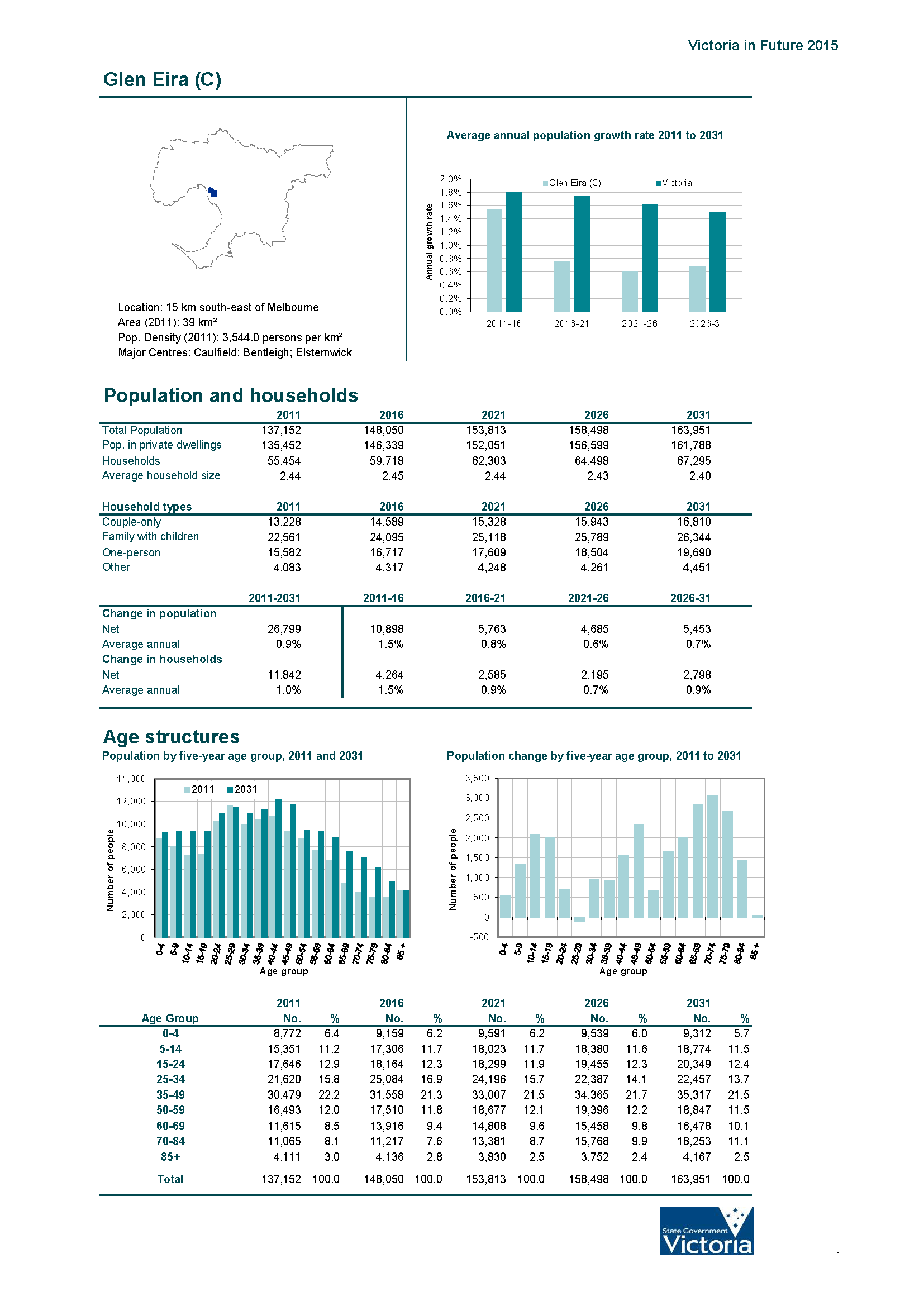
  • Based on the latest State Government ‘Victoria in Future’ population projections (2015), there is a projected need for an additional 7,500 dwellings in Glen Eira over the 15 year period from 2016 – 2031 of which 68% will be either ‘couples without children’ or ‘lone person’ households.

COMMENT

There are several unsubstantiated claims in the above which need to be seriously challenged. For example:

On what basis is the statement made that Glen Eira ‘will not be able to accommodate its share’ of population growth when the total number of new net dwellings in the municipality has risen by at least 350% for the past 3 years in a row? The planning scheme claims an average of 600 new dwellings per year is required. In 2014/15 Glen Eira had over 2000 net new dwellings. In the first quarter of 2015/16 (July to September) the figure, according to Planning Permit Victoria was 559 net new dwellings. For the second quarter this number rose to 634 net new dwellings. Thus, at least another 2200 new dwellings in a year if this rate continues. We also mustn’t forget that Newton and Hyams promised Guy an 80+ year supply of land and an 89 year supply if the comnmercial zoning is taken into account. Thus the ability to ‘accommodate’ new dwellings is well and truly there without the grand vision of potentially thousands more at Virginia Estate!

Given that ‘residential’ remains undefined, we seriously query the statement that Glen Eira from all its neighbours has the highest percentage of land zoned as Neighbourhood Residential. Bayside for example claims over 80% of its land is zoned NRZ whilst Glen Eira only claims 78%. Even this figure is a myth – NRZ constitutes just under 70% of the municipality and if the number of LARGE sized lots which can legally have many more than 2 dwellings are taken into account, then Professor Michael Buxton estimates that the Neighbourhood Residential Zones in Glen Eira amount to a paltry 55% of the municipality.

The most unbelievable claim however is that Bentleigh East has only ‘small areas of business land’ available for ‘higher density’ development. Not true! Bentleigh East has more land zoned as Commercial 1 than Elsternwick or Carnegie – both of which are supposed to be Major Activity Centres and Bentleigh East is a Neighbourhood Centre. Only Bentleigh (a Major Activity Centre) has more land zoned as commercial than Bentleigh East. The figures (in square metres) are:

Bentleigh East – 136,551

Bentleigh – 149, 768

Carnegie – 134, 415

Elsternwick – 125,628

Gillon et al are correct however in stating that the latest government population projections (ie Victoria in Future) state that there will be a need for another 7500 dwellings from 2016 to 2031. This figure will be well and truly met within the next 4 years at the current rate of over 2000 net new dwellings per year. And, please remember that this doesn’t include the additional 1500+ dwellings for the Caulfield Village Project that will be coming up pretty soon. In short, Glen Eira will well and truly have fulfilled its fair share of ‘accommodating’ population growth by 2020 – much less by 2031! Of course, no one dares say what figure equates with this ‘share’, nor what ‘capacity’ is and how much all of the necessary infrastructure upgrades will cost and whether or not any of this over-development is sustainable!

Gillon et al also claim that ‘couples without children’ and ‘lone households’ represent 68% of the required 7500 new dwellings. Not so! The Victoria in Future figures which they rely upon (see below) forecast that there will be 16,810 ‘couple only’ households, and 19,690 ‘one-person’ households in 2031. That makes a grand total of 36,500 households. The overall projection for 2031 is 67,295 households. Hence, the percentage is not 68% as claimed, but rather 54.23% on these figures.

We make these points not because we want to indulge in nit-picking, but when information is put before residents so that they can have an ‘informed’ say, then it is incumbent on the distributors of that information to ensure that it is accurate, honest, and not designed to obfuscate at best and mislead at worst.

Glen-Eira_VIF2015_One_Page_Profile-1


What Council doesn’t want us to know:

Ormond has an area of 2.05 square km. Of this –

  • 2.94% is zoned Commercial (no height limits)
  • 37.33% is zoned GRZ1/2 (three storey)
  • 0.49% is zoned MUZ (no height limit)

TOTAL = 40.76% of the suburb is handed over to developers

Please remember that once public parks, and other utility sites are removed from the overall acreage – since they will not be built upon (in the forseeable future) – then this percentage leaps even higher. Thus Ormond, which represents only 5% of the area of the entire municipality is designated to carry an inequitable proportion of new developments.


11 Malane Street ORMOND  – dwellings at rear

35 Thompson Street ORMOND  – 2 double storeys

291 Grange Road and 4 Walsh Street ORMOND  – 3 storey, 23 dwellings

280 Grange Road ORMOND  – 3 double storeys

2 Olympia Court ORMOND  – 2 double storeys

10 Tyrone Street ORMOND  – 2 double storeys

70 Ulupna Road ORMOND  – 6 double storeys

17 Wicklow Street ORMOND  – 2 double storeys (amended permit issued)

20 Wheeler Street ORMOND  – 6 three storeys & one double storey

29 Katandra Road ORMOND  – additional level plus 9 new dwellings

11 Thompson Street ORMOND  – 2 double storeys

720 North Road ORMOND  – 2 double storeys

25 Wicklow Street ORMOND  – double storey at front, single storey at rear

13 & 15 Murray Road ORMOND  – 3 new dwellings (permit)

9 Malua Street ORMOND  – single storey at rear

15 Wild Cherry Road ORMOND  – 2 double storeys (amended permit issued)

265 Grange Road ORMOND  – 11 dwellings (amended permit issued)

11 Bewdley Street ORMOND – 2 double storeys (permit)

198 Booran Road ORMOND  – single storey at rear (refusal)

289 Grange Road ORMOND  – 3 storey, 17 dwellings (amended permit issued)

532 North Road ORMOND  – 5 storey, 10 dwellings (refusal)

600-604 North Road ORMOND  – 4 storey, 34 dwellings (permit)

34 Cadby Avenue ORMOND  – 7 double storeys (permit)

13 Lillimur Road ORMOND  – 2 double storey and 3 three storey (permit)

534-538 North Road ORMOND  – 4 storey, 20 dwellings (amended permit issued)

24-26 Cadby Avenue ORMOND  – 3 storey, 12 dwellings

23 Collins Street ORMOND  – 2 double storeys (amended permit issued)

235 Grange Road ORMOND  – 2 storey, 6 dwellings (permit)

630-632 North Road ORMOND  – 4 storey, 14 dwellings (permit)

17 Bewdley Street ORMOND  – double storey at rear (refusal)

6 Florence Street ORMOND  – 2 double storeys (amended permit issued)

1 Florence Street ORMOND  – 2 double storeys (permit)

9 Bewdley Street ORMOND  – 2 double storeys (permit)

4 Ulupna Road ORMOND  – 4 dwellings (amended permit issued)

25 Wicklow Street ORMOND  – double storey at front & single storey at rear (refusal)

722 North Road & 62 Draper Street ORMOND  – double storey at rear (permit)

30-30A Holloway Street ORMOND  – 2 double storeys (permit)

15 Wild Cherry Road ORMOND  – 2 double storeys (permit)

Here is a list of the latest planning applications for Carnegie. The longer that nothing is done this destruction of Carnegie and other suburbs will continue.

285-287 Neerim Road CARNEGIE VIC 3163 – Construction of a six-storey mixed use building comprising sixty-one (61) dwellings and three shops, reduction in the associated car parking requirements, waiver of loading bay requirements and alteration of access to a road in a Road Zone, Category 1.

60-64 Rosstown Road CARNEGIE VIC 3163 – Demolition of existing buildings and the construction of an 8 storey mixed use building containing 40 retirement living apartments and a food and drink premises.

1032 Dandenong Road CARNEGIE VIC 3163 – Construction of a nine-storey residential hotel (comprising 49 lodging rooms), waiver of loading bay associated with a food and drink premises and a reduction in the associated car parking requirements

116-118 Grange Road CARNEGIE VIC 3163 – To construct a three storey building comprising 31 dwellings over a basement carpark, reduction of visitor car parking and to alter access to a Road Zone Category One

14-22 Woorayl Street CARNEGIE VIC 3163 – and for the 12 storeys, 134 apartments, there is now an amendment applied for.

Some background on this suburb is necessary. Glen Huntly is the second smallest suburb in the municipality coming in at 0.89 square km. Only Gardenvale is smaller at 0.25 sq km.

The planning history of Glen Huntly and how council has handled this area is abysmal. According to the State Government this is designated as a Major Activity Centre. Council regards it as a ‘neighbourhood centre’. Thus, when applications have gone into VCAT, the judgements have always been that State legislation over-rides council views and thus the developer has been granted his permits for far more intense development. What makes this situation even worse is that the State Government granted Council $45,000 to undertake the necessary work to produce a structure plan. Council returned that money and refused to implement any structure planning or anything else that could mitigate the ongoing development in Glen Huntly. So Glen Huntly is now stuck in the ‘never-never land’ of being technically a Major Activity Centre, with no Urban Design Frameworks, no parking precinct plans and no real vision as to the future of this suburb and its shopping strip. Retailers have time and again lobbied for improvements – to little avail. But development continues unimpeded – thanks to the zones.

What is even more questionable is the way the zones have been applied. The breakdown is:

31% of this suburb is zoned as GRZ1 and GRZ2 – ie available for 3 storey development

5.39% of the suburb is zoned Commercial 1 – no height limits

0.72% is zoned – Mixed Use Development (MUZ) – no height limits

Add in the Road Zone Category which also welcomes 3 storeys along major roads and close to half of Glen Huntly is ripe for the picking and far greater development. Glen Huntly does admittedly already have large numbers of units. These are products of the 50’s and onwards and will be demolished and new ones built of far greater density and even height.

Yes, there is plenty of public transport, and an incredibly busy rail crossing. But without proper planning that actually addresses the social, environmental and economic aspects of growth, Glen Huntly will continue along the path of unsustainable development.

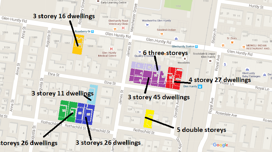
One perfect example of this in just one small area, is shown below. These are applications that have been decided since the zones and most have been granted permits. Those ‘refused’ by council will undoubtedly end up at VCAT.

gh

PS: here is an example of the point we made above – http://www.conquestea.com.au/news/2014/5/8-glen-huntly-block-sold-on-48pc-yield

UntitledCLICK TO ENLARGE

Why on earth does council even bother to put in submissions to state government reviews when they are invariably of such poor quality? Most are a few pages of self congratulation with a total lack of analysis, detail, and real contribution to the debate. And lest we forget, without endorsement via a council resolution and made public only ‘after the fact’. Frankly, council ought to be highly embarrassed in comparison to what other councils are capable of producing.

The latest effort concerns the State Government’s Plan Melbourne Refresh – a very, very important document that will have a major impact on strategic planning for Melbourne for the next 30 years. There is much in this document that should concern residents:

  • The ‘suggestion’ that middle ring suburbs should contain a 70/30 split of future housing growth
  • Notions of a 20 minute neighbourhood centre
  • Environmental sustainability
  • Changes to planning legislation, and much, much more.

So what is Glen Eira’s response to all these vital issues? Readers should note what our council, unlike countless others, fails to even mention –development contribution levies, tree protection on private and public land. We’ve uploaded the full submission HERE. Below are a few extracts and then a comparison with the views of other councils.

This is a very, very long post, but we urge readers to carefully consider the views presented below.

ON HOUSING AND THE 70/30 SPLIT

The Glen Eira Council view – It is proposed to accommodate the majority of new housing in Melbourne’s established areas, rather than in the growth areas. Glen Eira adequately accommodates population growth through its longstanding housing policies and suite of residential zones. These serve to co-locate higher densities of housing with public transport. A balance has been achieved in maintaining low scale residential areas and channelling housing into locations that can best support change. We have obtained government approval for maximum heights over all residentially zoned land where there were no limits before. Any move through Plan Melbourne 2016 to dilute the protection that Glen Eira has over its residentially zoned land will not be supported.

COMMENT

There is much in the above paragraph that needs to be challenged. For example:

  • How many residents would concur with council’s interpretation of ‘adequately accommodates population growth’ when all the complaints are about traffic mayhem, lack of public open space, lack of well designed buildings, and lack of infrastructure support.
  • What exactly does ‘higher density’ mean when neighbourhood centres such as McKinnon, Ormond, Murrumbeena, and East Bentleigh have the highest proportion of GRZ in their suburbs. Further, if public transport is the ‘key’ to locating ‘higher density’ then East Bentleigh certainly does not fit into this category.
  • What exactly does ‘locations that can best support change’ mean when council has not lifted a finger to introduce any parking precinct plans, urban design frameworks, etc. And how can certain ‘locations’ ‘support change’ when there is absolutely no preferred character statements in the planning scheme for any of the housing diversity areas?
  • Another major furphy is the claim that ‘maximum heights’ are the be all and end all of good strategic planning. And of course there is also the blatant unfounded mantra that ‘all residentially zoned’ land in Glen Eira is now better off. No mention of course of Mixed Use Zones which give a lie to the claim that all residentially zoned land now has height limits.

Thankfully other councils have taken the trouble to analyse and provide some data to support their assertions. They also oppose the introduction of the 70/30 split but at least their arguments have far greater validity, or raise concerns that are never mentioned by Glen Eira – ie neighbourhood character, heritage, employment, etc. Some examples:

BOROONDARA – Council is particularly concerned with the point around ‘low suburban density’ and “to encourage high urban densities and foster more diversity and choice in the housing sector, in closer proximity to public transport and jobs.” Many areas in Boroondara which adjoin public transport corridors consist of high quality residential streets which should be protected from intensive development, particularly apartment buildings. This includes some areas in the vicinity of train stations.

, accommodating the majority of new dwellings in established areas within walking distance of the public transport network can lead to a loss of trees and canopy cover in those areas. Therefore, any regulatory framework needs to take account of the local context and competing objectives and allow a level of discretion in managing these requirements. Further, Council questions the notion of protecting environmental and liveability assets on the urban fringe at the expense of another area’s environmental assets. This includes protecting valued tree canopy cover that reduces urban heat island effect and other valued aspects of Boroondara’s liveability.

The proposed housing target ignores the expectations which Boroondara has around the quality of new development. Importantly though, it makes broad based assumptions around the capacity of existing infrastructure in established areas such as Boroondara to support such intensification. In many instances, local development and social infrastructure already operates at or above capacity. Further, increasing development within these areas will only exacerbate the situation. Established area councils therefore require better infrastructure funding mechanisms to meet  increasing demand and renewal of infrastructure assets.

Council also refutes the claim being made in the Discussion Paper that Melbourne’s middle ring suburbs are accommodating a steadily increasing share of Melbourne’s housing growth – from 25% of building approvals in 2002 to 40% in 2014. This is on the basis of Footnote 6 in the Discussion Paper which states “This is an indicative measure of change in middle suburbs as building approvals include knock down and rebuild developments and therefore not necessarily net additional dwellings.

While knock down rebuilds distort the data, overall, new supply has increased in middle suburbs.” In other words, the Discussion Paper cannot readily point to any data which suggests that new dwelling supply in the middle suburbs has increased to a level which can justify a 70/30 target or sub-regional or municipal wide housing targets more generally. Further, the Discussion Paper notes that Melbourne 2030 aspired to a (roughly) 70/30 housing target, but (at best) Melbourne is being planned on the basis of 61% of new dwellings being located in established areas to 2051 under Victoria in Future 2015……Council does not believe the MAC or the Minister for Planning has strategically justified the imposition of a 70/30 housing target.


MONASH

The issues with existing infrastructure and service levels within the established suburbs of Melbourne is significant and is the major impediment to achieving the 70/30 split and ensuring the Melbourne continues to be a liveable and functional city. If the strategy is to encourage increased density within established suburbs (including parts of Monash), the need to upgrade and provide additional physical and community infrastructure needs to be given a much higher priority and be more clearly acknowledged and planned for in Plan Melbourne.

The Refresh paper identifies ‘low suburban density’ as a problem that needs to be addressed. However, it does not explain why this is a problem. In stating that this ‘problem’ will be overcome, it does not explain whether it still proposes to enable the retention of existing elements of suburban development that many within the community value – such as key elements of the existing neighbourhood character – and how the aspiration to increase the density rather than continue to expand the urban growth boundary will work with the ‘green our city’ elements of the Plan Melbourne strategy.

The Refresh Paper criticises the current aspiration in Plan Melbourne for 50% of metropolitan Melbourne being within the Neighbourhood Residential Zone because ‘applying a zone according to a percentage is an unconventional approach’., however it appears to be taking a similar approach to setting a 70/30 split for new development. Further justification should be provided to support this proposed split, which, if achieved, will lead to a significant change throughout suburban Melbourne. It is not appropriate, for instance to completely remove from any decisions around housing scale, consideration of the character of the area (built or natural / landscape character.

WHITEHORSE

Transport infrastructure has the potential to shape the built form and land use activities of our city. Many investment decisions are made based on the proximity to transport infrastructure regardless of whether it is included in a metropolitan or local planning strategy. However, simply being adjacent to a bus route should not automatically mean that development intensity can be increased. For example, the bus service may be infrequent, or there may be a sensitive environmental or neighbourhood character area nearby that warrants protection. One option is to rank bus or transport routes by frequency and quality before allowing more intensive development across the board. Council notes that it considered this sort of information when it introduced the new residential zones suite into its planning scheme, with this information balanced against environmental and neighbourhood character considerations.

Council would also like to emphasise the importance of integrating planning and building systems and a recommendation along these lines could be included in Plan Melbourne 2016 here. For example, single dwellings on a lot over 300 square metres in most instances do not require planning permission, which often results in a dwelling which is out of character with the surrounding neighbourhood. By being in the building system, Council cannot control the built form outcome on these sites. More consideration to neighbourhood character in the building system, or alternatively, consideration of single dwellings in the planning system, is needed.

MORELAND

Council does not consider increased density should occur at the expense of adversely affecting valued urban character by excessive building height, allowing sub-standard accommodation (as is occurring with some apartment developments) and on the assumption that there is adequate infrastructure in established areas to accommodate increased growth in established areas.

COMMENT

What stands out clearly from the above quotes is that Glen Eira continues with its myth about the new zones being in the ‘right locations’. Every other council comments on the fact that being close to a transport node is not necessarily the best or sole criterion for increased density – especially not if it means the destruction of heritage, neighbourhood character, and environment. But in Glen Eira we have heritage overlays smack in the middle of Residential Growth Zones because they are allegedly ‘close’ to railway stations; we have street after street of beautiful Californian bungalows and Edwardian cottages gone – ie Bent St., Bentleigh and Elliott St., Carnegie, plus countless others. And of course we have moonscaping that is allowed to go on unabated. And even with this unprecedented growth in Glen Eira, there is no attempt to re-introduce development contributions levies or a decent open space levy.

We are revisiting the carnage that is taking place in Carnegie because a definite trend is developing throughout the municipality. Once a particular street is gone, then developers move onto the next street – knocking on doors and attempting to entice residents to sell. Now that Bent Street in Bentleigh is gone, the vultures are moving into Vickery. In Carnegie, Elliott Avenue is lost, so now the next profit making venture is Tranmere. Within two months of purchasing properties there, applications have gone in. The box below indicates those properties which have been sold but an application has yet to be submitted. The same for the next street along – Hewitts Road.

We have already depicted what is happening along Neerim Road. The image below reveals in all its gory detail what is happening in the surrounding local streets. This is not planning. This is incompetence and indifference and one might even argue utter negligence. When just under 500 dwellings are crammed into 4 blocks with no consideration of traffic, open space, drainage, water tables, and general mayhem for residents as a result of all this cumulative building, and all done in secret and by stealth and collusion, then all these councillors must be held to account. What is even more unforgivable, is knowing that this is happening and refusing to do anything to ameliorate the damage – except of course to blame VCAT and the State Government for their own incompetence and unwillingness to do what should have been done ten years ago – structure planning, design and development overlays, parking precinct plans, development contributions levy, and a fair dinkum review of the planning scheme.

CLICK TO ENLARGE IMAGE

latest carnegie

True to form, the MRC continues with its money making ventures to the detriment of local residents – ably supported by council, by government, and by the pen pushers in the department. The latest outrages are:

  • Another rock concert in early December
  • This in combination with the month long circus
  • Another appeal by the MRC to VCAT over council’s refusal on the 30 plus radio towers
  • The department’s (and government’s) collusion in more compliance with MRC wishes
  • The failure to publish agenda items and minutes for the last Trustee meeting – despite the Auditor General’s report
  • The failure of council reps to utter a single word about what is going on
  • More than a year down the track since the Auditor General’s report and no visible signs of improvement in governance, access to the course, and the MRC giving a damn about the local community
  • Years down the track and not a whisper about the removal of training and the removal of fences as per original ‘agreement’.
  • And now we have Chanukah in the park with the prospect of fireworks. So much for the argument that ‘noise’ and horses don’t mix, therefore we have to keep the fences up to avoid horses bolting.

Thankfully divine providence may have intervened in blowing down the ramshackle fences along Queen’s Avenue – those very fences that were supposed to be removed ages ago and with council sharing the cost! See photos below.

Of far greater significance is this response to a complaint to the Minister in relation to the department’s removing all previous conditions it imposed on the granting of a permit for the outdoor cinema – namely – (a) trustee approval (b) land used to be under lease agreements and (c) current lease agreement in place. At the subsequent VCAT hearing which was appealed by a resident, the MRC magically pulled a new and undated letter from the department out of its bag of tricks. This new letter simply removed all of the earlier imposed conditions, making the granting of the permit a certainty. How convenient! How timely and how disgusting!

A complaint was then sent off to Minister Neville asking:

  • Why earlier conditions had been removed
  • Why an official letter was undated
  • Whether this was granted with ministerial approval
  • What was government doing in relation to the Auditor General’s report which was now over a year old

The full response is published here plus the pdf version

minletter_Page_1minletter_Page_2minletter_Page_3

Readers might also like to envisage what their land could look like once the decrepit, never maintained fences are permanently removed.

IMG_4984d

IMG_4985d

IMG_4988d

PS: It hasn’t taken the developer long to resubmit another application for Claire St., McKinnon. It is still 3 storey, and instead of 36 dwellings, the application is now for 33 dwellings. Yes, the VCAT decision certainly stymied the development, didn’t it? So much for Magee’s  faith in council’s planning scheme and its non-existent neighbourhood character statements for housing diversity areas.


  1. We are promoting additional transport options including more and better train, tram and bus services; car sharing, cycling and walking

Oh yes, Glen Eira is definitely transport conscious! That’s why the funding for bicycle paths has been cut despite budget promises. That’s why car sharing was put off and councillors never even told that a proposal had been submitted to officers years ago. When a report finally made it to council the decision was (typically) to delay for another year. The next year a tiny number of spots was set up. And how much credence do we give to council’s ‘promotion’ and ‘advocacy’ power, when they can’t even get a bus to run past East Boundary Road? Then there’s the fabulous Road Safety Strategy which lapsed in 2008 and hasn’t been updated, or newly ratified.

  1. We fine builders if they breach safety requirements on building sites

We challenge any reader to find one single vcat decision where council has sought an order against any builder for ‘safety’ breaches. There aren’t any. As for fines – well we’ve featured countless photos of unsafe and illegal works (for pedestrians) alongside development sites. How many of these have been fined – despite the fact that the offences occur day after day!

  1. We are advocating for all development costs to be paid for by developments and not fall on existing ratepayers.

Really? So is this the reason that Esakoff moved a motion at the last MAV state conference that basically asked for ‘all development costs’ – BUT ONLY FROM COMMERCIAL DEVELOPMENTS?!!!!!! Forget the fact that this was never endorsed by any formal vote much less discussed in council chamber with supporting reasoning. Commercial development almost pales into insignificance when compared to the developments occurring in GRZ and RGZ and now MUZ. Why these developments ARE NOT targeted is the $64 question?

The best of course is last –

  1. We are providing additional public open space and have imposed the highest Open Space Levy on multi-unit developments of any suburban council (estimated $5 million per annum)

Some very neat phrasing here which is technically not only untrue, but deliberately misleading. Glen Eira has NOT imposed the ‘highest’ levy on multi-unit developments. Plenty of other councils have much higher levies directed towards their activity centres, and suburbs where development is likely to occur at an intense rate. The perfect example of this is Stonnington which has the second lowest amount of public open space. In their proposed amendment they sought an 8% levy across the board in contrast to Glen Eira which has the least amount of public open space and only sought 5.7%. Admittedly Stonnington were not successful in getting their 8% for the entire municipality. However, they did achieve an 8% levy from developers in 4 suburbs, including Prahran and South Yarra. Achieving 8% from these 4 suburbs (given the size of these areas)plus the 5% from the rest of the municipality means that Stonnington is well ahead of anything that Glen Eira can achieve. Their Annual Report cites an INCREASE of $4.65 million in open space levies and this amount does not take into account the full year’s impact of the 8% in the four suburbs.

Nor is Stonnington alone. Moreland for example has had in place for years now the following levies for developments in their various suburbs –

Brunswick – 6.3%

Coburg – 6.8%

Faulkner – 5.7%

Glenroy – 6.5%

Then there’s Dandenong with 20% for this stated area – – Any residential or commercial subdivision in the area bounded by Springvale Road to the west, Cheltenham Road, Dingley Freeway Reservation, Dandenong Southern Bypass to the north, EastLink to the east and Hutton/Greens Roads to the south.

Further, whereas countless other councils included in their amendments the clause that for certain ‘significant’ sites , the levy payable be higher than the levy for other areas, Glen Eira council was quite prepared to accept the obscene figures of 4 and 5% for the 2000+ development of Caulfield Village. They were even prepared to accept the ‘normal’ rate for the Virginia Estate with its proposed 4,600+ dwellings of 5.7%.

Readers should also remember that at the 11th hour, council reneged on its two previous resolutions that all monies collected from open space levies would be used to PURCHASE ADDITIONAL OPEN SPACE. Instead, revenue is now basically ploughed into more of the same – mega palaces (ie pavilions) and car parks within parks that constitute ‘open space’. The only purchases of land in the past 12 years have been two properties in Packer Park and now one in Magnolia Road that could have been bought years ago for a much cheaper price given that there’s been the on-off-on farce with the public acquisition overlay. An appalling record for a council that has known for decades that open space is a priority for residents.

We estimate that with the population increase, open space in Glen Eira per resident will DECREASE if this current policy continues. This in fact has been admitted by the Open Space Strategy itself. So what is council doing about this? Bugger all in our view. Spending millions on ‘redevelopment’ is not the answer to the continued growing lack of public open space.

  1. While the boom is being driven across Melbourne by external factors, Council is acting to limit heights and contain development to strip shopping centres and public transport routes

More deceptive phrasing we suggest. Most people would interpret ‘strip shopping centres’ as meaning the actual ‘strip’ itself and not residential land that is some 800 metres from the street. The use of present tense is also a concern. If council is ‘acting to limit heights’ then apart from 2 amendments for MUZ there is no evidence to suggest that council is doing anything to change the zoning. Council ‘acted’ in 2013. They are now totally ‘inactive’ except to refuse application after application and blame VCAT for everything.

Finally, the fact that such a piece of shonky, deceptive and deliberately misleading (mis)information could have gone out to residents without councilors’ knowledge says much about governance in Glen Eira and the kind of leadership that has been at the helm for far too long.

« Previous PageNext Page »