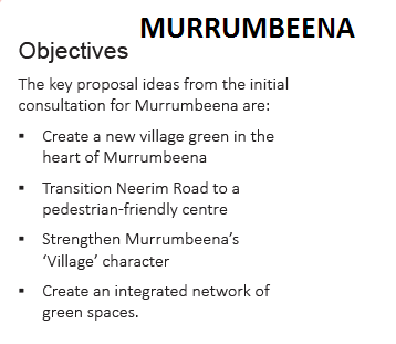
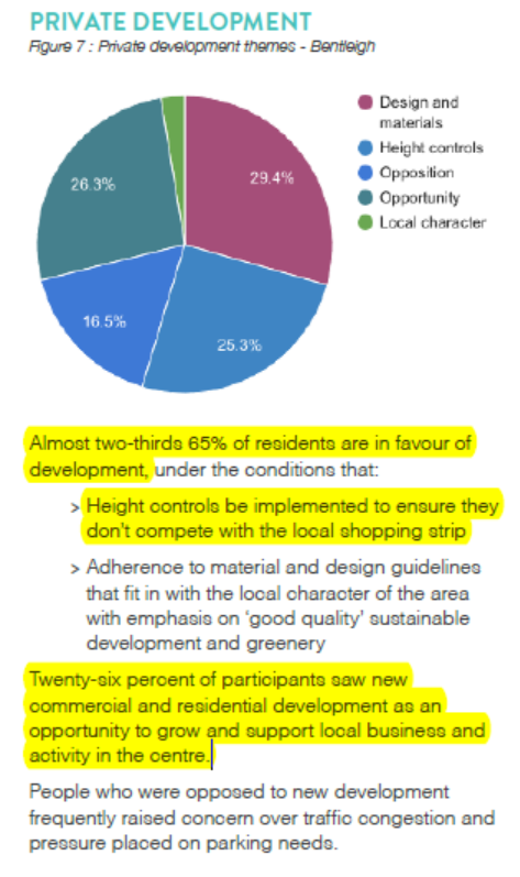
GE Transport


We’ve received the following email –

“Over the last few years, Bentleigh residents have been actively lobbying Council to put in the right controls and plans for future developments within the area.  As an outcome of this lobbying, some interim height controls have recently been introduced and Council is now also undertaking a Bentleigh shopping centre and surrounds structure planning process. This structure plan will significantly influence future development and FYI we have attached the preliminary draft.
A Community Forum is to be held on Wednesday 3 May, 6.30pm–8.30pm at the Bentleigh Senior Citizens Centre, 2 Arthur Street, Bentleigh to further discuss this preliminary plan.  It is important that residents attend to express views on this draft plan. 
 
Our thoughts on the preliminary plan are:  
  • There is no meaningful increase in open space and this is an issue with increasing development and also the general lack of open space in Glen Eira (lowest in Melbourne).
  • It is proposed that the existing car parks are to be consolidated into a multi-storey with the remainder to potentially be converted into more residential developments. This is not acceptable (Stonnington for example are doing one underground car park and developing open space above).
  • There is limited if any innovation or creativity in the plan.  
  • It is proposed that the library be relocated ($20M plus cost) however this was not identified as a need by residents.  (perhaps Council wants to sell off the current library site for a major development?). 
  • There is no direction included for future development heights. 
In summary, we believe that more work needs to be done to deliver a plan that is consistent in quality with other local government areas.  Please attend the community forum to again ensure Council clearly understands the views of residents.  Numbers are important, please also forward this onto friends.
Kind regards,
Centre Road Bentleigh”
centreroadbentleigh@gmail.com
++++++++
The relevant document is uploaded HERE

The so-called ‘Tranformative Concepts’ for dealing with the issue of parking to in our activity centres basically proposes

  • To flog off to private development as much of council owned car parks as possible – the terminology became ‘repurposing’!
  • To replace these car parks with one single above ground car park of at least 2 or 3 storeys.

One Mile Grid was then commissioned to survey ‘traffic’ flow in various streets. Their brief is defined as

Without stating the obvious, traffic flow and parking should be two distinct areas. It appears that council is determined to conflate both issues in the attempt to provide support for its highly questionable  recommendations! Not surprisingly, the results of the One Mile Grid analysis for Elsternwick, Carnegie, Bentleigh concluded that – The results show that all intersections analysed are currently operating under ‘excellent’ conditions during both the morning and afternoon peak hours with minimal queues and delays experienced by motorists. Only Orrong Road brought up a ‘good’ condition report rather than ‘excellent’. Many residents travelling along these roads/streets would beg to differ!

We are not traffic engineers. We are simply residents attempting to understand how such results can lead to the recommendations when:

  • No account has been taken of anticipated residential developments in the area
  • No account has been taken of car parking spots in nearby residential streets
  • No account has been taken of council car park occupancy rates
  • No account has been taken of occupancy rates in surrounding streets
  • No account has been taken of car ownership in the area
  • No account has been taken of parking restrictions in the area
  • No account has been taken of ‘through’ traffic – ie not remaining in the activity centre itself but just passing through

If council is indeed sincere about providing adequate car parking in its activity centres, then one must expect far more than a highly suspect report that does nothing more than focus on ‘traffic flow’ at certain intersections and concludes that all is hunky dorey for the most part and that public land can be flogged off for more private development.

By way of contrast we urge all residents to read the following that comes from Moonee Valley council’s amendment seeking to introduce both a parking overlay for the Moonee Ponds Activity Centre and a developer contribution of up to $13,000 per each car parking waiver. Then ask yourselves would Glen Eira ever attempt something like this given its pro-development agenda? We’ve uploaded the Moonee Valley traffic analysis, (a 175 page document) HERE

The current agenda features 3 items of particular interest. Two involve planning applications and the third is an officer’s response to a request for data on car parking waivers as a potential tool to use at VCAT. What is presented in each of these reports we find staggering and wonder what on earth is going on with planning in this council.

  1. Data on Car Parking Waivers

As per usual, the report  concludes that – It is considered that the extensive resources required to collate car parking waiver data could be more effectively directed towards creating the strategic basis for future car parking provisions. By doing so, much needed clarity can be provided to the town planning process in Glen Eira with subsequent benefits in defending VCAT appeals.

Backing up the ‘do nothing approach’ we get – A comprehensive audit of past planning decisions to obtain car parking waiver data would be a resource intensive exercise.

The ultimate recommendation therefore reads – That Council acknowledges this report and the strategic work that is underway which will ultimately lead to clearer and more effective planning provisions around car parking.

We also urge readers to note the following paragraph – In terms of specific controls,Council’s adopted Planning Scheme Review Workplan is committed to investigating the use of Car Parking Overlays and Parking Precinct Plans. These controls can provide greater clarity for decision makers, the community, and permit applicants through location specific car parking rates or developer contributions.

COMMENT

  • Resident comments on the planning scheme review were strongly in favour of developer contributions. Here we find ‘or developer contributions’ and this is the only time in the entire report that this issue rates a mention. Question: does council really have any intention of introducing a levy for car parking waivers? Given that the emphases is entirely on overlays and Parking Precinct Plans, which were promised in 2003/4 – our skepticism is probably warranted!
  • More of the same from this council? – ie let’s not do anything for the moment until our structure plans are in place! We do not see how the collation of empirical data should impact the ongoing development of structure planning. We would also assume that such data should be available on council’s computer systems. If it isn’t then why not? – especially when millions upon millions are spent on council’s systems. Surely it is time that some decent programming was undertaken so that all data pertaining to an issue is there at the click of a button?

 The Planning Applications

Below are two screen dumps that show the zoning for the applications. One in North Road, Ormond (5 storeys, 4 units) and one in Jasper Road, McKinnon (4 storeys, 4 units). Worth noting that council hasn’t used zoning maps, but instead included aerial shots which (perhaps intentionally) do not show up the planning contexts of these sites. Before proceeding further, readers might like to hazard a guess as to which application was refused and which was granted a permit?

  1. North Road Application

The officer’s recommendation was refusal. Yet scattered throughout the report we find the following:

  • The waiving of one visitor car spot was fine since – given the site’s proximity to Glen Orme Ave there would be ample on street car spaces for the one visitor car space shortfall
  • It is considered that the proposed development complies with Council’s Housing Diversity Area Policy. The height, density, mass and scale of the development is considered appropriate for this location.
  • The height and scale of the proposal are in keeping with the emerging character of the areaencouraged by State and Local Policy.The proposal has a maximum height of 16.7 metres. This is comparable to the approved development under construction next door at 534-538 North Road which also has a height of 16.7 metres.
  • On overshadowing – Whilst there will be overshadowing created by the proposal it is not considered to have any unreasonable impact on any adjoining land given the mixed use zoning to the east and west and the non-residential use immediately to the rear.
  • Internal amenity is deemed satisfactory

Thus on all the major ‘criteria’ this proposal meets the requirements. The refusal boils down to laneway access and car stackers and that the plans have not ‘satisfactorily demonstrated’ that access and layout provide a ‘safe environment for users’. So we now have the situation where an application for 5 storeys in a Mixed Use Zone and surrounded by GRZ, and other commercial sites that are already 5 storeys is refused on grounds that we doubt will stand up at VCAT. Besides, council already thinks that 8 storeys is appropriate for the Ormond Tower!

  1. Jasper Road Application

This application gets the nod of approval – despite the fact that it directly abuts a Neighbourhood Residential Zone; no onsite parking is proposed for the food outlet, and no visitor car parking for the 4 units (ie the magical number is 5!). We then get these extraordinary components –

  • Transport planning is against waiving of the car parking spot for the food outlet but in the end it is considered ‘acceptable’ to waive the requirement because of the ‘availability of public transport’, and ‘onsite car parking’. Isn’t North Road also close to public transport?
  • Internal amenity is only ‘generally appropriate’ and this can be fixed by a condition requiring a window or a skylight
  • The laneway of 3.5 metres is considered to be a ‘sufficient buffer’ to the NRZ residents
  • Car stacker is ‘generally satisfactory’ but more detail is required! (Note the contrast of this to the North Road application!)

CONCLUSIONS?

  • How about some consistency?
  • How about providing the full facts – ie width of laneway in North Road application?

Finally, just to add salt to the wounds,  the hole in the ground opposite the Jasper road application was originally granted a permit for 4 storeys in 2014 by council. The land and permit were then on-sold and we now have another application for –

The construction of a five storey, mixed use building above basement car park (comprising a food and drink premises and 45 dwellings); a reduction of car parking requirements; waiver of loading bay requirements; alteration of access to a Road Zone Category 1; construction of buildings and works within a Special Building Overlay

What does this all this say about council considering ‘cumulative impact’ on street car parking spaces and on the overall approach to providing transparent and credible officer reports?

Alarm bells should be ringing loud and clear for residents as a result of council’s latest news item on its proposed planning agenda. (See: http://www.gleneira.vic.gov.au/Council/News-and-media/Latest-news/Transforming-our-neighbourhood-together)

Several things are clear:

  • There will NOT BE ANY STRUCTURE PLANNING for the myriad of neighbourhood centres in the foreseeable future. All that will happen is the production of an Activity Centres Strategy which will consist of a broad ‘vision’ and ‘guidelines’ that will undoubtedly go into the Municipal Strategic Statement (MSS), plus its probable inclusion as a ‘reference document’.
  • The promise of community representation on a steering committee for the Virginia Estate development from the start of the project (strongly voiced by Athanasopolous and Delahunty) appears to have been conveniently forgotten given this carefully phrased announcement –

In order to form a community led vision and key objectives for the precinct, we are conducting our own community consultation. This will inform the development of a structure plan, which will guide what can be built on the site.

Visit www.gleneira.vic.gov.au/eastvillage to tell us what you would like East Village to look like into the future.

The opportunity to provide feedback on this stage closes Sunday 16 April.

There will be further opportunities to provide feedback once a draft structure plan has been developed.

  • Murrumbeena and Hughesdale, despite what the Transforming Concept document states, will not be part of the structure planning program. Instead, council will be getting ready for major ‘value capture’ development as a result of the level crossing removals – ie Recommendations to the State Government’s Level Crossing Removal Authority, with suggested projects for Carnegie, Murrumbeena and Hughesdale
  • Of greatest concern is the following –

We will use the community feedback on your concerns regarding development in residential neighbourhoods to develop new building and development guidelines.

There will also be a more detailed focus on Bentleigh, Carnegie and Elsternwick.

These guidelines will shape future development for land in activity centres zoned as Commercial One Zone, General Residential Zone and Residential Growth Zone.

No mention of reviewing the zones themselves or the borders of these zones. No mention as to whether these ‘guidelines’ will result in revised schedules or merely be part of the MSS. No mention as whether these guidelines will be a ‘one size fits all’ across all neighbourhood centres or will cater to the individual needs of each specific centre.

There is much in this media release that is (deliberately?) vague and even contradicts previous statements. What is entirely ignored, and of major importance is the Minister’s recent announcement of changes to Plan Melbourne via his gazetting of Amendment C110. The changes provide councils with the opportunity to rework their schedules and to provide clear ‘neighbourhood character objectives’ for both the NRZ and GRZ areas. This involves much, much more than ‘building and development guidelines’.

CLICK TO ENLARGE

Every single resident should read the ‘transformative concept review’ created by Planisphere. As a strategic document that is supposed to set the vision for the next 20 to 30 years, it falls well short of the mark in our view. Our concerns with this ‘review’ are numerous. In a nutshell, we find:

  • The objective is to sell off as much public land as possible
  • Recommendations are impractical and impossible to deliver
  • Corporate memory is non-existent. This results in unbelievable profligacy.
  • The incorporation of recommendations that are not what residents said they wanted, or ignoring what residents stated
  • Inaccuracies of statement after statement

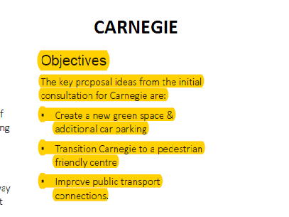
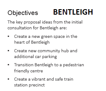
We will start off with an analysis of the Bentleigh ‘concepts’ and proceed with the bullet points made above as headings.

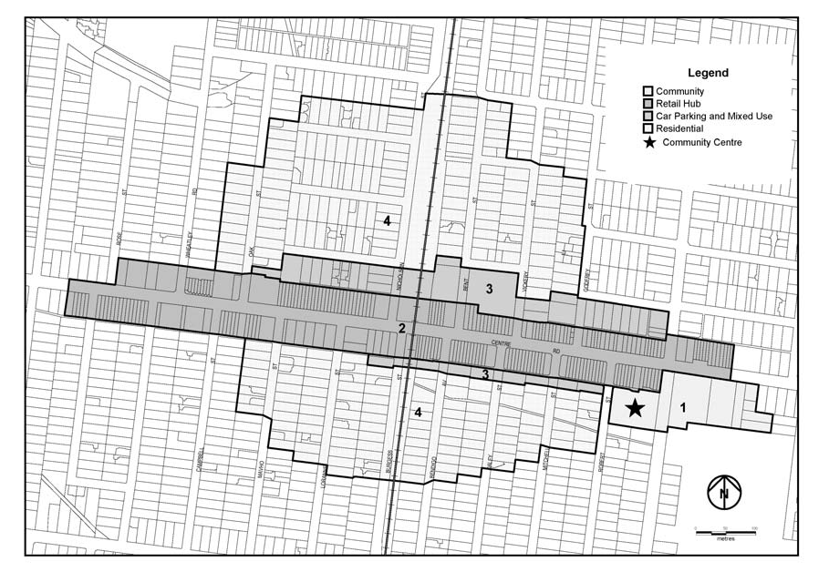
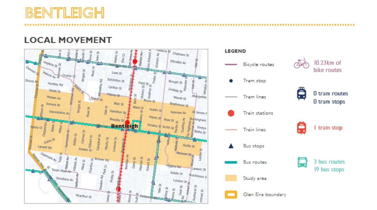
Selling off public land

The Bentleigh Activity Centre has 6 car parks (one of which council doesn’t even know if it owns – ie Aldi!!!). What is proposed in superb double-speak is a ‘repurposing’ – ie sell off- of some of these car parks to commercial interests and the creation of a multi-storey carpark of 2 to 3 storeys. No costings of course, no time scale, no nothing! Instead we are left with the ‘promise’ of increased car parking spaces. Yet, the sites of this new car park are also highly questionable. If all car parks go, then residents will be forced to congregate even more in one single high rise concrete structure. Will this create less patronage of the centre or more? What is the evidence to support either position? And why high rise? Why not underground with a large public open space above as Stonnington is doing? We appreciate that council must recoup some money for any of these ventures, but the outcomes must be positive and not create more traffic problems which we believe this will do, or be deleterious to businesses when people can’t get easy access to car parking.

Impractical Recommendations

The desire for more shops, restaurants, cafes, and night-life sounds wonderful. The reality is that council has very little control over what kind of shops go into an area. Their level of intervention is limited to brothels, porn shops, massage parlours, alcohol etc. Council cannot tell an applicant to open up a restaurant when he wants to open up a $2 shop! And if hours are extended for restaurants until late evenings, then what impact will this have on parking. Will all restaurant patrons go and park in the high rise car park or settle for side streets that are closer to their chosen destination?

Also proposed is the creation of several ‘green spines’, the closing off of Vickery Street and the extension of the rotunda area across Centre Road to meet up with Vickery Street. We fully agree that the rotunda area has been an eyesore for years and that something needs to be done about this site. As far back as February 2010 there was ‘public consultation’ on the rotunda and the following resolution was passed on the 2/2/2010. Needless to say, the issue of the rotunda and the actions councillors resolved to happen were never heard of again!

That Council:

  1. Under take a proof of concept to redevelop the Bentleigh Rotunda site with acommercial caretaker presence at the rear and public open space adjacent to Centre Road.
  1. Prepare artist’s impression of what the redeveloped site may look like from Centre Road and Daley Street (to assist with further community consultation).
  1. Obtain advice to determine the most suitable commercial instrument to use to develop the site with a commercial component.
  1. Consider a further report on this matter (including suggestions for further community consultation) on completion of the above. (unanimously passed)

Traffic along Centre Road is already crawling. Closing off more access to Centre Road will surely force cars into streets that remain open. And what of the ‘green spines’ that are to run behind the shops? What happens to the truck deliveries that service these shops from these areas? Will they be forced into Centre Road itself?

Profligacy and Waste of Public Monies

3 options are provided for the current library site in Jasper Road, including ‘develop for mix of car parking/commercial/residential opportunities’ or ‘utilise for new centralised green park’. The last option is ‘retain library in existing position’. Thus 2 out of 3 recommendations involve moving a recently redeveloped library that cost ratepayers millions and will cost heaven knows how much more to move and establish in another centre. Here is a run down of just part of what council spent on this redevelopment alone –

That Council appoint Core Properties Pty Ltd CAN 007 192 056 as the contractor under Contract Number 2010.009 Bentleigh Library Building Refurbishment Works at 161 Jasper Rd, Bentleigh for the sum of $677,703.40 (GST incl) in accordance with the terms tendered. (minutes of 11/8/2009). (The contractor lists the resultant project at $1.5m)

That Council appoint WM Loud (Aust) Pty Ltd ACN. 005 711 222 as the contractor under Contract No. 2009.039 Bentleigh Library Car Park Rehabilitation & Associated Landscaping Works at 161 Jasper Rd, Bentleigh for the sum of $506,042.02 (GST incl) in accordance with the terms tendered (minutes of 19/5/2009)

Also of interest is that in March 2007 an officer’s report into the feasibility of developing a new Bentleigh Library and Community Centre including a Library, Maternal and Child Health and associated child development and care services, senior citizens and general community facilities and amenities . was tabled. The report then stated that – The cost of building a new library and community centre with the functions set out in Council’s resolution (which are greater than the facilities at Carnegie) is estimated to be $19-$24M. (Minutes of 20/3/2007). Hence the project was shelved and only the library redevelopment was undertaken. That was ten years ago. How much would this cost today?

Inaccuracies

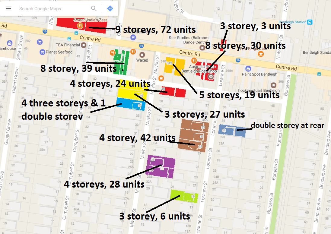
On page 16 of the Bentleigh report we get this paragraph – Buildings are generally up to two storeys in height, with newer development up to four storeys. There are isolated older buildings dispersed throughout. The report is dated March 2017. To therefore claim that ‘newer development’ is ‘up to four storeys’ is unacceptable given that permits have already been granted for 8 storeys well before the writing of the report, and council’s own position is that it wants a ‘preferred’ height limit of 5 storeys.

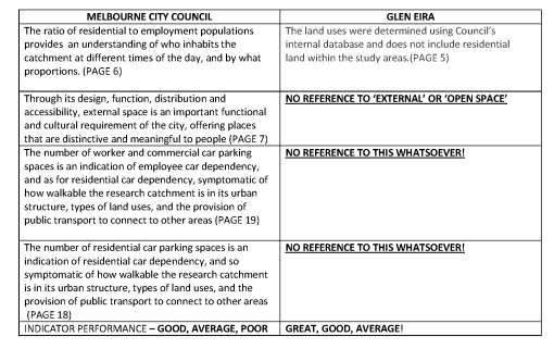
On page 3 of the report we are told – This report reviews the options for transformation projects in each centre, from an urban design perspective.  An urban design approach that totally ignores built form and major development in the entire activity centre is certainly not a ‘comprehensive urban design’ evaluation in our view.

There is much, much more that could be said about these ‘concepts’. We urge all residents to voice their opinions and to insist that if council is truly committed to genuine consultation that the community’s views be incorporated into a vision that is truly representative of good strategic planning!

PS: NEWSFLASH ON INTERIM HEIGHTS FOR BENTLEIGH & CARNEGIE. SEE: http://www.nickstaikos.com.au/media-releases/new-planning-controls-to-protect-bentleigh-and-carnegie/

The 3 images above depict an aspect of structure planning undertaken by different councils – and stand in stark contrast to how Glen Eira Council is approaching the same task.

Please note that:

  • Each of these councils includes vast areas of ‘residential’ land
  • Borders are clearly defined and are ‘reviewed’
  • Notations that ‘heritage’ areas to be ‘generally excluded’

Glen Eira’s structure planning concentrates exclusively on the main shopping strip (ie Centre Road, Glen Huntly Road, etc) and the surrounding residential areas (ie the zones) are ignored. The use of the term ‘shopping strip’ alone in the surveys was the clear giveaway!

Given that ‘structure planning’ is meant to deal with ‘activity centres’ as a whole, and that activity centres include far more than a single shopping strip, we find the approach taken by council far from adequate – especially in light of the countless comments already submitted by residents complaining about overdevelopment in their side streets. What we are therefore seeing is NOT a structure plan for an activity centre but a half baked approach to genuine community consultation and proficient strategic planning.

Finally, Council’s planning scheme clearly outlines what it considers to be an activity centre. Here is the one for Bentleigh –

By ignoring the residential areas included in the activity centre, we can only wonder at the efficacy of any resulting structure plan. If no current data on population, car ownership, developments, etc is included in the design of any future structure plan, then the very validity of the plan must be questioned. As shown in previous posts the vast majority of development is not occurring in the areas zoned Commercial, but in the abutting residential areas. The impact of this must be reviewed and questions as to capacity, infrastructure needs, etc. addressed before any window dressing occurs for the central shopping strips alone.

Residents do have cause for concern given the ‘results’ which have thus far been produced by council in regard to the structure planning ‘consultations’. The plans are supposedly based on community feedback. Yet very little of what residents wrote is reflected in any of these documents. When even council is forced to admit that ‘opposition’ to ‘private development’ features prominently in most of the areas listed, but fails to make an appearance in the ‘objectives’ section listed for further action, then something is drastically wrong.

Below is what council sees as the road map for the next phase of ‘consultation’ for four of the designated activity centres – (the screen dumps come from the ‘Transformational Concepts’ report). Please keep in mind that no explanation has been given why Hughesdale and Murrumbeena should be included as part of the first cabs off the rank instead of say Ormond, McKinnon and even Balaclava, Glen Huntly and Caulfield which according to the latest version of Plan Melbourne are now designated as MAJOR ACTIVITY CENTRES!

What we have here is thus another example of a Clayton’s Consultation where decisions have already been made and the ‘results’ of  community input are deliberately distorted, or completely ignored!

The image above comes from Council’s summary of community responses to the Bentleigh ‘shopping strip’ online survey. According to the ‘facts’ presented here we are meant to believe that 65% of respondents are in favour of ‘private development’ (whatever that means!) – but with some constraints on height and ‘character’. Please note that of the valid 248 comments included in the document, the claim that 65% are ‘supportive’ does indeed represent an entire work of fiction. What is most disappointing about this report is:

  • The failure to acknowledge the countless comments that specifically referred to overdevelopment in the various side streets of Bentleigh – ie the damage done via the zones
  • The exclusive emphases on the ‘survey’ comments rather than the opinions expressed via the forum PLUS the apparent ‘editing’ of the forum comments themselves – ie not every comment made online is included in the resulting ‘summary’. Here is one example of what’s been omitted – The critical and major issue is the urgent implementation of height and appropriate building form controls. Interim measures are required immediately to ensure a planned future for the shopping precinct. The inappropriate and unplanned overdevelopment must be stopped now to ensure that structure planning results in long term plan
  • The total inconsistency in the reporting across all suburbs. Surely a report on community responses to one issue should include identical categories in the respective pie charts?
  • Could this possibly be another example of ‘community consultation’ designed to ‘endorse’ the decisions that have already been made behind closed doors?

Presented below are the pages that are council’s version of the online forum comments plus another graphic displaying what has been happening south of Centre Road Bentleigh since the introduction of the zones!

Council’s recent release of documents related to its ‘structure planning’ must, in our view, be treated with a huge grain of salt. This is the first in a series of posts analysing what has been placed in front of residents and how valid, accurate, and transparent these documents really are. Are we again being taken for a ride via data that are highly questionable and manipulated to present already determined decisions?

The first document is called ‘Activity Centres Snapshot: February 2017’. It purports to be ‘based on similar studies carried out by Melbourne City Council’ in its Places for People and Local Liveability 2015 Study. (uploaded HERE). The aim is to ‘provide a more comprehensive understanding of how the city performs for everyday people’. Yet, when both of these documents are compared, the Glen Eira version is anything but ‘comprehensive’. For starters we are told that:

  • All data used in this document is current (February 2017) except for residential and employment population data, which is taken from the Census carried out by the Australian Bureau of Statistics in 2011. How much credence should then be placed on this ‘snapshot’, especially given the rate of development since 2011?
  • The land uses were determined using Council’s internal database and does not include residential land within the study areas. How on earth any study can ignore ‘residential’ is simply mind boggling! Or is this simply more confirmation of the fact that council is focusing exclusively on the single street shopping strips themselves and not the zones that have blighted countless people’s lives?
  • Then of course, there is this wonderful ‘escape clause’ – Disclaimer: this document is provided for information purposes and does not claim to be complete. Although due diligence has been applied to ensure that all information contained in this document is accurate, it cannot be guaranteed that this document is without errors or omissions. Why publish anything if its accuracy and integrity cannot be assured?

We’ve drawn up a table below which illustrates just some of the differences between the Glen Eira version of good planning and what the Melbourne City Council included in their study. To therefore claim that this piece of paper represents a ‘snapshot’ of what is happening in Glen Eira, and is the basis upon which to plan for the future, is not only ludicrous, but deliberately misleading and invalid.

MELBOURNE CITY COUNCI1

Compounding all of the above, we then have neat little maps of the various areas under consideration – with no explanation, no criteria, and again, lines drawn on a map. The City of Melbourne’s study clearly defined how its various neighbourhood borders were selected –

To understand the Local Liveability 2015 Study area at a local level, 5-minute walking catchments were identified across the study area to effectively act as a sieve and allow for disparate urban geographies and their components to be compared ‘apples for apples’. For greater rigour and to reflect the true local urban conditions, real 5-minute walking catchments were determined rather than standard ‘as-the-crow-flies’ walking radii.
Local Movement as defined by Melbourne then includes ‘Car Spaces Per Employment’, ‘Car Spaces Per Resident’, and the numbers of bus stops, tram stops, etc.  All Glen Eira includes are the latter. As mentioned previously parking does not figure at all. Instead we are presented with nice little maps, that may look ‘professional’ and pretty, but which don’t reveal very much when terms, borders, and important categories are omitted!
The Bentleigh snapshot is typical. Depicted is a huge area that is overwhelmingly ‘residential’ – which we’re told has been excluded. Thus, what knowledge and what kind of basis for future planning can be drawn from this effort? Finally, Melbourne has no qualms in pinpointing areas that are ‘poor’ in terms of ‘liveability’ for its neighbourhood areas. In Glen Eira of course, the category ‘poor’ simply does not exist – everything is ‘great’ or ‘good’!!!!!!!!!

We’ve received the following notice and handout –

« Previous PageNext Page »