Another incredible agenda of 273 pages. More developments feature and more ‘let’s do nothing’ recommendations.

Caulfield Village Height Limits

Item 9.10 is the officer report on councillors’ request to investigate the options available to provide more rigorous height provisions for the Smith Street precinct.

This report is the outcome from previous council resolutions that in typical fashion have gone nowhere and disappeared into the dustbin of history. On February 7th 2017, councillors passed this resolution –

requests officers to undertake a review of the current town planning controls applying to the Caulfield Village Development given that planning scheme controls have evolved since the approval of Amendment C60. The review is to identify any potential gaps in the controls including the loss of on-street car parking around the Caulfield Village development site. Should any gaps be identified officers are to commence a planning scheme amendment process to address these gaps.

Then again on the 21st March there was this resolution –

That Council:

  1. notes this report;
  2. notes potential gaps identified in the current controls relating to social/affordablehousing, and the precinct boundaries;
  3. commences a planning scheme amendment process to address these gaps in thecontrols, and seeks authorisation from the Minister for Planning to prepare and exhibitthe amendment; and
  4. seeks a further report from officers on the options available to provide more rigorousheight provisions for the Smith Street precinct..

Nothing could be clearer we maintain that the ‘order’ to begin a planning scheme amendment. It is yet to materialise.

So for this council meeting we get the following recommendations –

That Council:

  1. notes this report.
  2. notes that Council could apply to Minister for Planning to change the current preferred height controls within the Smith Street precinct to mandatory maximum height controls.
  3. reserves its consideration of height provisions for the Smith Street precinct until after Council has completed its Activity Centre, Housing and Local Economy Strategy, and resultant built form guidelines for Glen Eira’s activity centres.

The proffered arguments for this ‘do nothing’ approach are indeed lamentable.

  • First we’re told how wonderful the existing Incorporated Plan is – ie This process provides a significant incentive to the developer to comply with the heights and setbacks set out in the Incorporated Plan. Really?!!!! So this is why the developer has gone to VCAT time and time again and increased his heights and setbacks for Precinct One and now had major victories with Precinct 2? How much longer will council continue with this charade that the Incorporated Plan is worth the paper it is written on?
  • Next, there is the usual scare campaign – ie requesting the Minister to authorise mandatory height limits could very well result in greater than the current 20 storey ‘discretionary’ height.
  • Then finally we get the ‘promise’ of ‘action’ down the track – ie The Activity Centre Housing and Local Economy Stategy will result in ‘built form’ guidelines for Glen Eira’s activity centres, such as the Caulfield Station Precinct. It is recommended that any further consideration of the Smith Street precinct occurs after the completion of the built form guidelines. What this recommendation does not highlight is that ‘guidelines’ are just that, and in no shape or form are they a better option than mandatory provisions.
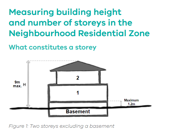
  • Nor is there any discussion of whether any proposed ‘mandatory height limits’ will be judged on the number of storeys, or what is known as the Australian Height Datum (AHD). We have already seen that because of the slope of the land Precinct 1 now has 6 storeys instead of 5, and the Smith Street precinct is mooting 22 storeys instead of the wonderful council promise of 20 storeys!

Conclusions 

  • How many more times will council resolutions be ignored and not acted upon?
  • How many more times will residents have to wait before council gets off its backside and actually begins reforming its all too numerous mistakes of the past?
  • How many more times will this administration use ‘scare tactics’ as the excuse to not attempt anything?

VCAT has handed down a decision for 411-15 Glen Huntly Road Elsternwick. The permit will allow:

  • Demolition of existing building at 415 Glen Huntly Road on land affected by Heritage Overlay;
  • Partial demolition of buildings at 411 and 413 Glen Huntly Road on land affected by Heritage Overlay;
  • Construction of an Eight Storey building with basements, comprising 37 dwellings and 2 shops on land within a Commercial 1 Zone and affected by Heritage Overlay;
  • Reduction of the standard car parking requirements associated with a shop, residential car parking and residential visitor car parking in accordance with Clause 52.06; and
  • Waiver of the requirement for a loading bay in accordance with Clause 52.07

There was an earlier VCAT decision in July 2015 which refused a 6 storey dwelling because of poor ‘internal amenity’. The developer returned with an application for 8 storeys and an increase in dwellings on a site of 649 square metres. The earlier 2015 decision saw no problems with height nor impacts on ‘heritage’.

Thus council has had 2 years since this previous decision to shore up its Heritage policy – and remember this policy dates back to 2003. Thus we have another example of council (and long serving councillors) sitting on their hands for 14 years whilst the horse has well and truly bolted. Admittedly Council moved in March 2017 to ‘update’ its policy – but this was only to include the ‘update’ from years ago as a ‘reference document’ to the Planning Scheme.

http://www.theage.com.au/victoria/planning-minister-richard-wynne-rejected-planners-input-on-175b-crown-tower-20170605-gwkfdz.html

Minister Wynne recently gazetted Amendment VC110 which introduced several changes to the residential zones – ie those sites included in the Neighbourhood Residential Zone (NRZ) and the General Residential Zone (GRZ) in particular. With much fanfare it was declared as saving residential backyards and improving ‘liveability’ (see: http://www.premier.vic.gov.au/saving-the-backyard-and-boosting-liveability/).

By way of summary, here are the major changes introduced. We will then analyse their potential impact.

  • The mandatory height limit in the NRZ changed from 8 metres to 9 metres.
  • In the GRZ the mandatory height changed to 11 metres from the previous 10.5 metres.
  • The mandatory maximum number of 2 dwellings per lot in the NRZ have now been removed. There is no limit on the number of new dwellings now allowable in the NRZ. The GRZ has never had a limit imposed.
  • If councils have mandatory heights already imposed via their respective zones and accompanying schedules, these will remain for the time being. Councils have three years to fall into line with the new legislation. They can change the new height limits – but only go higher, not lower!
  • A new category of ‘Minimum garden requirement’ has been introduced for all NRZ and GRZ lots over 400 square metres. If the property happens to be 399 square metres or less, then none of these new requirements for a ‘garden area’ apply.

So what does all this mean? – especially for Glen Eira and its zoning? Whilst there are some potentially positive changes, notably for the GRZ, there are also some very negative ones that have the potential to impact severely on development throughout both the NRZ and GRZ areas.

Height Limits

With wonderful sleight of hand, Wynne has included this sentence in the requirements for both NRZ and GRZ –

A basement is not a storey for the purposes of calculating the number of storeys contained in a building.

By raising the maximum height limit in the NRZ from 8 to 9 metres, coupled with the single sentence above, this has the potential to allow a three storey building to be developed in the NRZ and 4 storeys in the GRZ – especially if part of the ‘basement’ is at least below ground level and does not exceed 1.2 metres above ground level. The following depicts why this is a real possibility.

Dwelling Numbers 

There is absolutely nothing to stop a developer now deciding to construct a 2 storey apartment block on a 500 square metre site and incorporate as many units as he possibly can in the NRZ. Making things even easier for him is the fact that the government refused to introduce mandatory apartment sizes in its recent Better Apartments ‘standards’.  We suspect that the NRZ can now look forward to plenty of apartment buildings that quite feasibly could contain anything from 8 apartments upwards depending on lot size. If the site is very large (ie over 1500 sqm) then the sky is literally the limit!

Garden Requirements

Here is an image of what Wynne and the department would like us to think will be the outcome of his ‘garden’ requirement and why this is totally misleading –

  • Anything above 1 metre in width can be included in the 25/35% ‘garden area’. Hence, instead of one single decent sized ‘garden area’ that is portrayed in the image, the reality is that the end product will see narrow strips at the sides and back of developments that will count as ‘garden’ space.
  • Here’s a hypothetical to see how Wynne’s ‘garden requirements’ could work in practice. We have a 650 square metre site in either the General Residential Zone or the Neighbourhood Residential Zone. Site coverage in the GRZ is 60% – ie 390 square metres therefore taken up by the actual building and 50% in the NRZ (IE 325 SQUARE METRES). Since the hypothetical site is 650 square metres, the mandatory ‘garden requirement’ is 227.5 square metres (at 35% of site). 130 square metres (20% of the total block area) is required to be permeable in the GRZ and 162 square metres in the NRZ.  This would mean in the GRZ case that 97.5 square metres of the 227.5 square metres (43%) of the garden area could be non-permeable.
  • Another problem with Wynne’s ‘garden area’ is that swimming pools and tennis courts would be included in the calculation as well as concreted, uncovered patios. Since the permeability requirements aren’t mandatory we could literally be seeing those ‘liveable’ backyards become concrete!

The legislation is poorly drafted (intentionally?). We also find it incredible that instead of ‘road testing’ the legislation first, and that it be accompanied by Practice Notes, we first get the legislation and then there’s the mad scramble to provide guidance via the drafting of some Practice Notes. The best example of the current confusion is Wynne’s references to subdivision and the phrase ‘vacant lot’ as a trigger for subdivision. Planners have already questioned what the term might mean – ie a previously demolished dwelling? An untenanted, empty dwelling? Each interpretation has its ramifications that are yet to be made clear and most importantly, capable of holding up before VCAT and possibly a court of law.

After two years of ‘review’, the outcome is nothing more than another ‘gift’ to developers and the further erosion of residential amenity. Quite clearly the intent was to diminish the clear lines between the Neighbourhood Residential Zones and the General Residential Zones. The NRZ is now ‘open for business’ to developers. And Council? Not a peep! And we’ve already seen one application in Bignell Road exploiting the changes!

PS: A related article from The Leader – http://www.heraldsun.com.au/leader/inner-east/plan-melbourne-20172050-activist-fears-city-will-become-gridlocked-nightmare-under-blueprint/news-story/61a8be3ee70efeb6b27c912ce41ed4cb

The above image comes from page 93 of council’s commissioned Housing Report. We highlight this paragraph because it illustrates completely how statistics can be used to distort situations, especially when only half of the story is presented.

Both Plan Melbourne and Victoria in Future 2016 are cited, leading to two possible scenarios required  to meet Glen Eira’s population growth – either 28,600 net new dwellings, or 32,500 required dwellings. Thirty two thousand certainly sounds a lot, and is intended to. What readers need to remember is that these figures are projections for the next thirty-three (33) years up to 2050 or 2051. Thus if we are indeed in need of another 32,500 new dwellings, then all Glen Eira has to average is 970 net new dwellings per year! And for the past 5 years this pro-development council has averaged 2000+ per annum – OVER DOUBLE WHAT IS ‘REQUIRED’!!!!!

Why couldn’t the document state this simple fact? Why do residents have to perform some basic arithmetic in order to come up with a scenario that is far more ‘realistic’ and accurate? When put into perspective isn’t the issue that Glen Eira doesn’t need to:

  • Expand its activity centre borders as we suspect will happen
  • Maintain a growth that is double and triple what is required
  • Maintain a growth that increases density per square km that is totally unsustainable
  • Make Glen Eira the development ‘capitol’ of the Southern Region?

To illustrate all of the above here are the ABS building approval figures up to the end of March 2017 – that is, 9 months of building approvals. At this rate the year’s total will be approximately another 2000 new dwellings.

Residents need to understand that council’s mantra is and has always been to welcome development irrespective of its cost to residential amenity, sustainability, and overall density. Residents also need to demand answers as to why this council isn’t screaming blue murder as a result of Wynne’s recent amendments and why no genuine attempt is being made to rein in development?

Finally, it is also worth pointing out that the very figures presented by Plan Melbourne are highly questionable. Victoria in Future 2016 only shows projections up to the year 2031. Yet Plan Melbourne sites this source as projecting to 2051. There’s also the question as to how Glen Eira is supposed to represent 26% of the required new dwellings when there are only 4 municipalities included in the Inner Southern Region – Glen Eira, Stonnington, Bayside and Boroondara? Surely that’s 25%? Plenty of other stats in all of these documents can and should be called into question.

Thanks to the Stonnington agenda, we now know that the state government’s promise to facilitate social housing is a step closer. We’ve uploaded Stonnington’s submission, plus provided extracts from their officer’s report. Whether or not this will be another example of government policy railroaded through on the back of poorly drafted legislation and with little thought given to the countless loopholes that can be exploited, remains to be seen.

Here are the officer report extracts –

Proposed Planning Reforms

Council was notified on 22 May 2017 that the Minister for Planning is seeking feedback on proposed reforms to the Victoria Planning Provisions to provide permit exemptions or streamline permit application processes for specified accommodation land uses.

Comments on the proposed reforms are due by Friday, 16 June 2017. Due to the short consultation timeframe and the timing of Council report cycles, this provides Council a short time frame to review the reforms and prepare a submission for Council endorsement.

Facilitation of public housing

The Government argues that there is a pressing need to increase the supply of social housing in Victoria. The reforms are intended to help support government policy to replace ageing public housing stock and develop new public housing.

The reforms seek to streamline the planning permit process for the development of no more than 10 dwellings on a lot by, or on behalf of, a public authority such as the Department of Health and Human Services (DHHS). It exempts assessment under Clause 55 (ResCode) and car parking requirements if specified requirements are met. In addition, it exempts an application from public notice and review requirement

Rooming house

The term “shared housing” is proposed to be replaced by the term “rooming house” (a newly defined land use term under Clause 74 of the Planning Scheme) which clarifies that other land uses such as a backpackers accommodation, boarding houses and hostels cannot benefit from the provision. The provision proposes to provide a permit exemption for use and development of land for a rooming house where specified requirements are met supporting the development of ‘domestic scale’ rooming houses under the proposed draft provisions.

The requirements propose limits of 12 persons, 8 bedrooms and a gross floor area of 300 square metres. It proposes to exempt applications by public authorities from public notice and review requirements.

Council is not confident that the draft controls will result in a high level accommodation that is respectful of its neighbourhood character, context or surrounding amenity.

The draft controls propose to provide a reduced assessment threshold to a proportion of Public Housing, Community Care Accommodation and Rooming Houses. This raises concern in relation to whether adequate levels of internal amenity, managing off -site amenity impacts and how successful integration of development within its neighbourhood context will be achieved.

The lower assessment threshold may lead to an increase in such developments, creating a loop hole for the development of sub -standard accommodation if the buildings are retro fitted into private apartment buildings in the future.

It is also considered that the Clauses as drafted will pose challenges in the extent of public notice and review exemptions. The lack of notice and review means that where otherwise affected parties would be able to make submissions, there will not be an opportunity to do so.

The proposed exemption from notice and review may result in a disconnected community and potentially increased compliance expectations on Council

Stonnington’s submission uploaded HERE

In March 2017, Wynne gazetted Amendment VC110 which is the latest version of the residential zones and the one trumpeted to ‘save our backyards’. Practically every other council has at least put up on its website information about this amendment. Many have included an officer’s report in their agenda papers and some like Banyule and Boroondara (see images below) have voiced strong concerns/objections to the amendment. Glen Eira on the other hand has maintained a stony silence! Not a public peep has come out from any councillor and certainly not from any administrative quarters via a media release, a web page announcement. Nothing but silence! Why? Is this another foray into keeping the public ignorant? Or is it more to do with not wanting to ‘antagonise’ Wynne and the Labor party so that brokered secret deals can go through? How much is politics at play here rather than transparent planning? Why, when after years and years of patting itself on the back for achieving such ‘largesse’ from Matthew Guy (ie mandatory heights, 2 dwellings per nrz) is council now silent when these very ‘achievements’ are about to go down the drain?

And if we are correct, then the rot has already started for the Neighbourhood Residential Zones. An application is in for 76 Bignell Road, Bentleigh East. This is a site in the NRZ of 580 Sqm and was sold in September 2016 for $1m. The application is for 3 attached double storeys! And all is ‘legal’ since March 2017 thanks to Wynne. We therefore urge all residents in both the NRZ and GRZ zones to be on the look out for this new threat to our neighbourhoods – one that council is hoping will slip through unnoticed no doubt! Wynne’s amendment we suggest sits well with council’s long history of a pro-development agenda. Like VCAT it will eventually become the convenient scapegoat for over a decade of appalling strategic planning and gang after gang of complicit councillors.

We will report on the potential impacts of Wynne’s amendment in posts to come. In the meantime, here are some screen dumps from a recent Banyule council meeting and the letter that Boroondara sent out to its residents –

We have received several emails asking us to elaborate on our statement that council will be enlarging the activity centres and thus paving the way for more intense development throughout Glen Eira. This post explains our reasoning.

According to the planning scheme the ‘housing diversity’ areas include all those sites zoned as General Residential Zone, Residential Growth Zone, Commercial and Mixed Use. NO NEIGHBOURHOOD RESIDENTIAL ZONING (NRZ) IS INCLUDED IN HOUSING DIVERSITY. These come under the umbrella of ‘minimal change’ – ie the NRZ zones.The image below makes this clear

Thus we have the current situation where each and every ‘activity centre’ is zoned as either RGZ, GRZ, C1Z OR MUZ. Where these sites meet ‘minimal change’ (ie NRZ) then that determines the border of the respective activity centre.

If we are to believe what is written in council’s commissioned housing report, then all this is about to change. Here are a couple of screen dumps from this document which refer to NRZ sites WITHIN ACTIVITY CENTRES! As we’ve stated – there are no NRZ sites in any activity centre. The fact that this ‘research’ is done on this basis can only mean one thing in our view – council will be extending the borders to most activity centres. And once extended we would bet that the classification of these sites will not be NRZ any longer!

Isn’t it about time that council came clean on what it is really doing? How much longer will residents be kept in the dark? And how about council answering the most basic questions concerning:

  • definite time lines
  • what is ‘capacity’ and why do we even contemplate the need for another 20,000+ dwellings?
  • how sustainable is any of this?
  • what is council doing about parking and traffic management?
  • what is council doing right now about amending the schedules to the zones?
  • why can other councils keep working on amendment after amendment and council has done bugger all, except to rezone land for more development?

There can be no doubt that council is gearing up for:

  • Facilitating increased major development throughout Glen Eira
  • Expanding the borders of activity centres

Residents need to question why given:

  • That Glen Eira is already the third most densely populated municipality in the state – only behind Melbourne and Port Phillip – both of which are special cases anyway.
  • That no estimates of infrastructure costs, traffic management costs, etc. have been included in any forecasts
  • No realistic estimates of what Wynne’s new legislation will mean for accelerated development in both Neighbourhood Residential Zones and the General Residential zones. The housing paper we believe fails to adequately account for these changes and their potential for much more development.
  • No realistic estimates of what demands will be placed on open space and how much meeting the most minimalist standards will cost
  • No consultation with residents as to whether or not they are accepting that various activity centres should be able to have a dwelling ratio of over 200 dwellings per hectare! A hectare is 10,000 square metres. If we assume that the average housing block is 500 square metres, this means that 20 houses will be replaced by over 200 in countless residential streets.

Featured below is the more detailed prognosis for our suburbs from council’s commissioned report –

Carnegie – Assumed 36% of developable land in the centre for future residential development of at least 200 dwellings per hectare.

Caulfield Junction (inc. Caulfield Village) – …. it is assumed that 36% of developable land in the centre for future residential development of at least 200 dwellings per hectare.

Elsternwick – development. Assumed 36% of developable land in the centre for future residential development of at least 150 dwellings per hectare.

Bentleigh – Assumed 28% of developable land in the centre for future residential development of at least 150 dwellings per hectare.

Moorabbin – Assumed 28% of developable land in and around the centre for future residential development of at least 150 dwellings per hectare

Murrumbeena – Assumed 28% of developable land in and around the centre for future residential development of at least 150 dwellings per hectare

Caulfield South – Assumed 28% of developable land in and around the centre for future residential development of at least 100 dwellings per hectare.

Glen Huntly – Assumed 28% of developable land in and around the centre for future residential development of at least 100 dwellings per hectare.

Caulfield Park – Assumed 28% of developable land in and around the centre for future residential development of at least 100 dwellings per hectare.

Hughesdale – Assumed 24% of developable land in and around the centre for future residential development of at least 100 dwellings per hectare.

McKinnon –  Assumed 24% of developable land in and around the centre for future residential development of at least 100 dwellings per hectare.

Ormond – Assumed 24% of developable land in and around the centre for future residential development of at least 100 dwellings per hectare.

Ripponlea – Assumed 20% of developable land in and around the centre for future residential development of at least 75 dwellings per hectare.

Gardenvale –  Assumed 20% of developable land in and around the centre for future residential development of at least 75 dwellings per hectare.

Alma Village – Assumed 20% of developable land in and around the centre for future residential development of at least 75 dwellings per hectare.

Patterson –  Assumed 20% of developable land in and around the centre for future residential development of at least 75 dwellings per hectare.

East Bentleigh –  Assumed 16% of developable land in and around the centre for future residential development of at least 75 dwellings per hectare.

We urge all residents to read the Housing commissioned paper and to digest its message. (UPLOADED HERE). Query the assumptions! Query the figures and finally query the (secret) agenda! We will be doing this in future posts.

http://www.theage.com.au/victoria/melbournes-ugly-scaffolding-set-for-a-makeover-20170525-gwcze9.html

Aesthetics as covered by The Age article above is one thing. Public safety, and treating council’s laws with absolute disdain is another. Not for the first time have we featured photos sent to us by residents of development sites that should be closed down or at the very least fined severely on a daily basis. Council however seems to be unable to enforce its own and state regulations – or worse, simply turns a blind eye despite the fact that residents do ring through time and time again over individual sites and complain bitterly.

The following photos all come from Mimosa Road, Carnegie where two major 4 storey developments are currently under construction. Please note the following which are all contraventions of council’s Local Law as well as state legislation:

  • No display of any hoarding permit which mandates that there must be at least 1.5 metres provided for pedestrian use. Plus, non securely attached hoardings!
  • Turning footpaths into lunch areas with chairs etc. contravenes council’s Local Law and also represents a pedestrian/disability hazard by blocking the footpath
  • Forcing people onto the road without clear sightlines is another no-no and the orange etching on the grass plus the pathetic piece of wood designed to act as a plank for wheelchairs is also unacceptable. Then, simply parking over this ‘access’

Council could literally be raking in thousands of dollars per day if they were to do their job properly. Are they? And if they’re not, then why not?

There was a very, very good turnout at tonight’s forum. We estimate approximately 85-90 residents. Also in attendance was Mr Steve Dunn acting CEO of the VPA (Victorian Planning Authority) and some of his colleagues.

The evening was again facilitated by Ms Nathan. Following her introduction which assured residents that nothing was ‘set in concrete’ and that everything was on the table, Aiden Mullen from council presented the results of the previous survey and council’s plans for further community input. This was followed by Mr Dunn’s presentation where he outlined the role of the Victorian Planning Authority and also provided overheads of the work they have done thus far – eg. several projects in Bundoora (3000 dwellings on a 104 hectare site and another one (Polaris) which has 1100 dwellings on 12 hectares). Interestingly all the slides of development presented by both Mr Mullen and Mr Dunn did not show any buildings of higher than 4 or 5 storeys for the latter and 3 storeys by council!

The audience was then asked to discuss at their tables the ‘vision statement’ and to answer the following questions:

VISION STATEMENTEast Village will be a thriving, mixed use precinct with a focus on employment, innovation, education and housing affordability

THE QUESTIONSDo you agree with the vision? How would you change it? What would the table’s vision be? (10 minutes).

What are the tables 3 priorities to include in the structure plan in order to achieve this vision? And how?

RESPONSES

Each table then reported back to the entire audience on their discussions. We summarise the major points below:

  • Problem with language – people did not know what ‘innovation’ referred to – far too vague.
  • More clarity required about the term ‘affordable housing’ and this should be changed to ‘diversity of housing’
  • Questions about what ‘village’ means and is this a ‘village’
  • Traffic and car parking are major problems
  • Desire for low rise townhouses. Some tables nominated a maximum height limit of 3 storeys and others up to 6 storeys.
  • Diverse views on the need for another school and whether this should be part of McKinnon High or another new school entirely.
  • Open space that wasn’t covered over in concrete
  • A new supermarket required but also not a threat to other existing businesses in the area.
  • No waiving of car parking spots
  • Environmental sustainability across the entire centre including flood mitigation

COMMENTS

How useful an evening like this has been remains to be seen of course. It will largely depend on how many of the above comments find their way into the final structure plan. In other words to what extent is government, council and the developer listening to the locals? Will we have maximum height limits of 3, 4, or 5 storeys? Will we have open space that is more than a ‘village square’ surrounded by high rise? Will we have 2, 3, or 4000 apartments and only a handful will be categorised as ‘affordable/social housing’? Will the traffic mayhem of North and East Boundary Roads be fixed by appropriate infrastructure? Will an entire new school really happen and how big will it be? Will retail offer fair dinkum employment opportunities or are we going to get employment as slave labour (ie kids) working for McDonalds and supermarket check out staff? What carrots will be dangled in front of major companies to come to Virginia Estate and will this cost ratepayers anything? What is the appropriate percentage mix of retail, to housing, to industry/offices – 50/50? 70/30? Who decides – the market, council, state government?

There are literally a myriad of unanswered questions and in our view a vision statement as presented above does not clarify anything. The questions that go with the vision statement are also far from ‘objective’. They are there to simply endorse the ‘vision’ rather than to really elicit knowledgeable commentary from residents.

PS: not one councillor was in attendance that we saw!

PPS: it has now been months since talk of establishing a ‘community reference group’ to work with council on the East Village project. Thus far – silence! Will this group eventuate and if so will it be when all the planks have already been set in stone?