GE Governance


Residents have their chance to address council on the budget this Tuesday night. 17 submissions have been sent in – a huge increase. The comments (highlights presented below) range from unacceptable charges and rate increases, poor policy documents, that are so out of date they belong in a museum, and lack of real consultation with residents.

Before presenting these ‘highlights’, we draw readers’ attention the most ridiculous set of tenders ever entertained by this council. When councils all over Victoria are being urged to tighten their belts and be accountable for the expenditure of ratepayers’ hard earned dollars, Glen Eira council is its wisdom is about to spend a million dollars on unnecessary ‘trifles’. It appears that for this council the major priority is to promote itself rather than address the needs of residents. Here are the details of the proposed tenders –

  • Mystery shopping program for GESAC – $40,000
  • Point of Sale system for Glen Eira Sports and Aquatic Centre – $150,000
  • The supply of promotional items for sale/giveaway from Glen Eira City Council – $400,000
  • And $390,000 to plant a few trees and grass in the Carnegie forecourt! (mind you, no ADDITIONAL open space, just the usual expensive tinkering – which begs the question why the first design was ever countenanced).

This expenditure should be read in the light of resident comments below –

Deliberate, repeated deception and secrecy in governance and cover up continuing

I note that Glen Eira’s half-page Street Lighting policy dates from 2002 and as such is completely out of date. I suggest that this policy be comprehensively revised with the inclusion of the environmental and health impacts of light at night before such a program (ie LED) is contemplated.

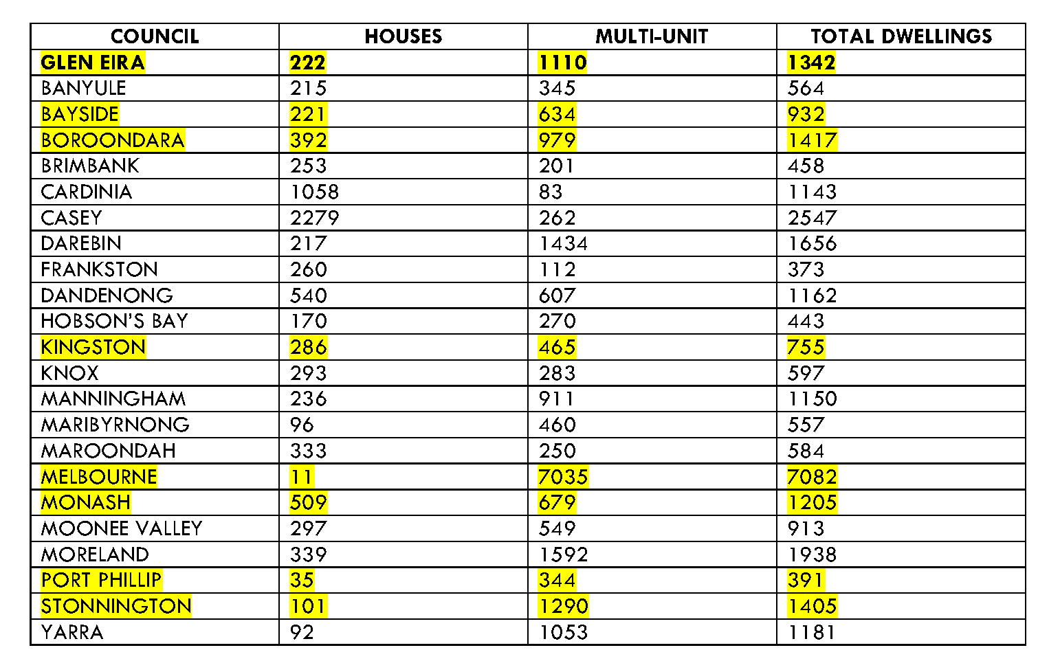
…this year’s planned increase in rates of approximately 4.94 per cent, which is almost four times the current inflation rate, is completely unnecessary and unacceptable. (Please note: this resident has obviously been duped by the manner in which council has publicised its rate increase. The increase is 6.5% and NOT 4.94%!)…During March of this year, most of the kerbing, footpath and landscaping at this location, has been reworked at considerable expense to the Ratepayers of the City. In my opinion, the works appear to have only completed superficial changes, which I regard as unnecessary. Furthermore, it is unconscionable that the developer of this site is able to reap the profits, when the roadworks surrounding this property development have been required to be reworked as a direct cost to Glen Eira Ratepayers. ….it appears that the Council decision makers are intending to apply different principles because their accountability is obscure, and Ratepayers do not generally feel that the outcome of the objection process is likely to be worthy.

I consider the $450,000 allocated towards the construction of the Eskdale Road/Fitzgibbon Crescent Caulfield North new open space to be an unnecessary and terribly wasteful expense. The proposed new open space is small and is unwarranted as it is located within easy walking distance of Caulfield Park and therefore is unlikely to be used by many residents.

Supply of places (childcare) may exceed demand due to council charging too high fees for the service the centres provide. Whilst I am very conscious of the quality of care and the homely environment provided for children at the centre my child attends (which was a primary factor in choosing this centre), it is my understanding that other centres in Glen Eira provide nappies and even cooked meals. Parents have to provide these at the conoucil-run centre in Carnegie. Other centres also provide excursions…..It is actually my understanding that kinder places are funded by the State or Federal Government (which makes the cost significantly lower for parent who have the flexibility to put their child into a straight-up kinder program) and that the City of Glen Eira is not passing that funding on to parents through reduced fees for children in the Kinder-year.

Currently, there is no allocation in the budget to redress the steady erosion of resources and facilities for passive usage of Caulfield Park….Since the Conservatory has been removed, there is no shelter in the western end. This means that young and old have neighter shelter from the scorching heat of the summer sun, nor from biting winter wind and rain.

I appreciate that there are many opportunities for community input and consultation to Council deliberations generally, however feel that one area in which these opportunities are lacking, is in relation to the Children’s Centre. As far as I am aware, formal parent involvement in the governance of the centres is limited to an annual online survey, the results of which are not communicated. Input from the parents and the community has the potential to have direct impact on the bottom line, through suggestions that have cost savings, or revenue enhancement, implications.

As I can see the tennis courts are regulary used (ie at Carnegie pool) and appear to be in very good condition, why is $130,000 being spent to change them? Has there been any community consultation, and what is the reason for the change? (ie to convert to small sided soccer pitch)

The Draft Community Plan – Transport – page 28 proposes to improve pedestrian and bicycle facilities but “only where balanced against maintaining traffic flows”. Is the council really wanting “more traffic faster” as the overriding objection of transport planning in Glen Eira? The priority for more faster traffic reads like a strategy from the 1960’s for freeways and not a way to create a livable local community with good sustainable transport choices. Instead the plan and councils transport planning programs and works should firstly prioritise pedestrians, then bikes, then public transport and lastly cars – as is current transport planning best practice…..The Walking Plan is mentioned in the transport section but is missing from the list of all strategies on page 42 – is that an oversight or a statement of priority?….The proposed investment of $150,000 would be insufficient to build more than 1 set of traffic lights on the Rosstown Rail Trail – let alone the many that are required. Does carrying over funds from last year also indicate poor action on implementation and a need to review how the plan is managed?

How can $50,000 be allocated to Thomas Street Reserve, McKinnon? Surely, four large old trees surrounded by bark and drought affected grass, on a double housing block, doesn’t constitute a ‘Reserve’….Only two seats are provided at bus stops between Thomas Stret and Wheatley Road North side and no seats on the South side. Elderly people sitting on fences and students sitting on the kerb, waiting for the bus, is demeaning.

VCAT is no friend of residents. However, if there ever was a more clear-cut condemnation of the ineptitude, and indifference of Glen Eira City Council to land use planning, then it comes in the decision for a 12 storey, and 134 units, plus shops, plus waiver of some visitor parking in Woorayl Street, Carnegie.

Every single resident should read the judgement and in particular the following extracts. They will show:

  • How policies that expired in 2007 have not been touched since
  • How maps in the planning scheme contradict policy
  • The failure to include overlays and urban frameworks – the ‘tools’ that Sounness so easily reneged on
  • This judgement reads as a litany of utter failure to protect neighbourhoods

http://www.austlii.edu.au/au/cases/vic/VCAT/2015/735.html

“We have found that although a 12-storey building will represent a highly visible built form change on the review site and nearby, this outcome is supported by policy that aims to increase intensity of development in activity centres close to public transport and provide the highest density of dwellings within Urban Villages including Carnegie. In reaching that conclusion, we have had regard to the absence of overlay or schedule provisions containing preferred heights and the local policy framework that provides little specific guidance on height or built form outcomes sought for the area.

The policy includes a map that divides the Carnegie Urban Village into nine precincts. The review site is within Precinct 1 that contains most of the area between Dandenong Road and the railway line. There are specific built form policies for all precincts except Precinct 1. The policy for Precinct 1 expired on 30 September 2007. There was reference to the expired policy in various submissions and evidence at the hearing. We indicated at the hearing and confirm in this decision that we give no weight to a policy that, despite referring to objectives for the precinct, expired over seven years ago

We find clause 22.05 on Urban Villages provides general direction on how Carnegie is expected to change. Its general principles are relevant and its Precinct Map provides direction on land uses, street interfaces and the treatment of public places. It provides little direction on the height, scale or form of new development, which we consider are important elements of any statement of preferred character. As such, we find this policy allows great scope in interpreting what the preferred character might be.

The Urban Village Structure Plan is a Reference document to this policy. It identifies a Precinct layout that differs from what is in Clause 22.05 and includes the review site in a Mixed Use precinct, east of Koornang Road. It says this area is ideal for high intensity activity due to its proximity to the shopping centre, public transport and major road network. It says the Council should strongly consider purchasing the open space north of the railway reserve and when purchased redeveloped with seating, play equipment and lighting. It recommends that development avoid overshadowing the rail reserve’s open space. It also encourages a pedestrian walkway between Woorayl and Arawatta Streets, a new road link between these streets and the closure of the western end of Woorayl Street. We place little weight on this document. As a reference document, it provides background to the Urban Village policy. It does not substitute for the policy and is not a replacement for the expired policy in the Planning Scheme for Precinct 1. As such, we find it does not justify the Council’s submissions regarding the height of new development on this site or its submissions that that the site should provide a pedestrian link between Woorayl and Arawatta Streets.

A building must not exceed the maximum height specified in a relevant Schedule; however, the relevant Schedule sets no maximum height. The decision guidelines require consideration of State and local planning policy and the Guidelines for a development of five or more storeys.

  • Council is concerned that the proposal will result in significant shadow and associated loss of amenity to the public open space area on the south side of Woorayl Street. In the context of the urban village, Council contends this is unacceptable especially given there is no other open space in the activity centre or nearby. The unreasonable shadow impact in Council’s submission will occur in winter as well as spring and this outcome is contrary to policy that seeks to improve the quality of open space, to the DSE guidelines that aim to avoid reduction of sunlight to important public places and to the concerted efforts Council is making to improve quality and quantity of open space in the municipality. The City of Glen Eira Open Space Strategy 2014 recommends securing this reserve as a high priority and identifies it as an important open space for the community living and working north of the railway line. In addition, this Strategy includes guidelines that seek between 9am and 3pm a minimum of three hours direct sunlight at the winter solstice and five hours at the equinox.
  • It is the applicant’s submission that it is not reasonable to expect that there will be no winter shadow to the reserve opposite. The applicant says the shadow outcome is acceptable having regard to its role and function, the limited improvements, the public use zoning and the lack of any evidence that Council has a prospect of obtaining the land for public open space.
  • Ideally there would be no shadow cast to the reserve but on balance we consider the extent is acceptable having regard to the following matters:
  • The reserve is owned by VicTrack and zoned for Public Use –Transport. It is not zoned for public open space and it is not subject to a Public Acquisition Overlay.
  • Although there are Council aspirations to secure the reserve for open space, that conclusion is not assured. The plan to secure the reserve has been in place since 1998 with no apparent advancement to that end and the uncertainty about the future of the land is increased by potential rail works to provide grade separation at Carnegie with implications for land owned by VicTrack

The objective in the DSE Guidelines to avoid reducing sunlight to public places applies to ‘important’ places and refers to the option of local policy identifying public spaces that should be protected at the winter solstice. There is no such policy in the Planning Scheme but rather in a reference document and the importance of the space is reduced, in our view, by its unknown future.

  • Council criticised the proposal for failing to provide a public pedestrian link from Woorayl Street to Arawatta Street through to Dandenong Road as sought in the expired local policy for the precinct and supported by the Urban Village Structure Plan 1999. Council says such a link would assist in increasing permeability though the precinct and specifically would assist with improving walkability and access to the train station.
  • We have already indicated that we give the expired policy no weight. Whilst we acknowledge the Urban Village Structure Plan refers to a pedestrian link that would improve connectivity to Dandenong Road, we consider a 15 year old suggestion in a Reference document with no ongoing translation into policy is difficult to support. There are no obvious pedestrian link opportunities between Arawatta Street and Dandenong Road with no footpaths adjacent to the vehicle access to the car park, no pedestrian entry to the Spotlight development from Arawatta Street and Council did not identify any detailed analysis to support the concept. We consider the need for the link is not clear and would not refuse the application for this reason.

There are 134 dwellings proposed of which 123 are one or two bedroom and 11 are three bedroom.

According to the constant Council propaganda regarding development, what is happening in Glen Eira is not unique and has got nothing whatsoever to do with the new zones. It’s all part of a universal ‘building boom’. To support this notion, officer reports (ably supported by Hyams and others) have cited building approval figures as the conclusive proof. Unfortunately for Council, the facts do not support the spin!

Below is an Australian Bureau of Statistics table providing the data on building approvals for the 2014/15 financial year to date. (ie to March 2015). Please remember that building permits usually come AFTER planning permits. Thus the figures below for Glen Eira do NOT include the countless additional permits granted for the Residential Growth Zones and the General Residential Zones or those land banking sites that have been sitting idle for eons. Other points that influence the figures presented below are:

  • Moreland, Moonee Valley and several other municipalities decided to apply to the Residential Zones Standing Advisory Committee to introduce their zones. The committee refused to support these council’s proposed amendments and thus these municipalities were left in limbo – unable to introduce their desired zoning. On 1st July these councils had the General Residential Zones automatically imposed on them. Some amendments are still waiting approval. Glen Eira of course rushed its new zones in secretly and they became ‘law’ on the 23rd August 2013 providing ‘certainty’ to developers that they could get their 3 and 4 storey multi unit developments in immediately.
  • Stonnington has had many building permits. However, Stonnington has 6.2% of its municipality designated as Commercial. Glen Eira has roughly 2.2%. Hence much of Stonnington’s development has occurred in these commercial areas. Boroondara and Yarra also have a huge percentage zoned C1Z.
  • Port Phillip is in the unique situation of having Capital City Zone status for part of its land – plus 4 major activity centres and miles of Mixed Use Zoning – especially along Bay Street, St. Kilda Road etc.
  • Glen Eira is NOT an ‘inner suburban’ municipality such as Port Phillip, Stonnington, Yarra, etc.
  • Other councils have had more building permits issued than Glen Eira. However, readers need to look at the ‘nature’ of these new buildings. Many are for single houses. In Glen Eira the vast majority (ie ratio of 5:1) has occurred as multi-unit development – courtesy of the new zones.
  • The Lobo request for a report of a little while back unfortunately did not ask for figures on Commercial and Mixed Use zones. This is vital to glean a full picture of what is happening – especially when an application can come in for 2 token shops and 100+ units on top! Thus far very little development has occurred in Glen Eira’s commercial centres when compared to what is happening in the growth and general residential zones. It is these two latter zonings which are taking the full brunt of over-development in our view – again thanks to the zones! This must again cast doubt on the spin and efficacy of commercial centres providing the bulk of development.
  • The final point that requires consideration is the number of new dwellings per municipality and the size of the municipality. For example: Boroondara, Kingston, Manningham and plenty of others are double or triple the size of Glen Eira. Erecting 1000 new dwellings in municipalities such as these, compared to Glen Eira will in all probability have a limited impact on overall DENSITY. In Glen Eira, the impact will be far worse, with the resultant loss of environmental and social amenity.

We’ve uploaded the full EXCEL spreadsheet HERE and provided a summary of the data below. We urge readers to do their own comparisons with other councils. We take no responsibility for the ‘totals’ as presented in these figures.

COUNCIL

Second reading

MrWYNNE (Minister for Planning)—I move:

That this bill be now read a second time.

Speech as follows incorporated into Hansard under sessional orders:

Victoria’s planning system encourages community participation in decision-making. This is especially true of the planning permit process. The community enjoys broad rights in the permit process to consider and object to proposals and to seek review of decisions through the Victorian Civil and Administrative Tribunal (VCAT).

Community participation has many benefits. It improves the decision-making process and often leads to better planning results. Objections can provide important insights into the potential effects of a proposal, not just on those who live or work nearby but also on the wider community. In the right circumstances, the number of objectors to a proposal can also provide such insights.

This bill amends the Planning and Environment Act 1987 to ensure the extent of community objection to planning proposals is considered. It does this by requiring the two key decision-makers in the permit process—responsible authorities and VCAT—to have regard, where appropriate, to the number of objectors when considering whether a proposal may have a significant social effect.

This new requirement must be considered before a decision or determination is made, together with other matters that must be considered under the Planning and Environment Act 1987, such as the objectives of the act, the planning scheme, and any significant economic and environmental effects that the proposal may have.

The bill amends two key provisions in the Planning and Environment Act 1987: sections 60 and 84B. Section 60(1) sets out matters a responsible authority must consider before deciding on a permit application. Section 84B sets out an equivalent set of matters that VCAT must consider. The bill inserts the new requirement in both sections to promote consistent decision-making.

Decision-makers must already consider whether a use or development may have a significant social effect. Social effects are not defined in the act but may include matters such as:

  • services.
  • access to social and community facilities.
  • choice in housing, shopping, recreational and leisure services.
  • community safety and amenity.
  • the needs of particular groups in the community, such as the aged.

This bill makes it clear that the number of objectors may be a relevant fact that ought to be considered in this assessment.

Whether it is appropriate for the number of objectors to be taken into account in a particular case is a matter for the decision-maker. In making a decision about whether to take into account the number of objectors, the decision-maker may be influenced by:

  • what the objectors have said in their written objection about the proposed use or development.
  • whether the issues raised in the objections are relevant planning considerations and relate to the reasons why the proposal requires a permit.
  • whether the issues raised in the objections point to a significant social effect on the community which is supported by evidence.

It will be for the responsible authority and VCAT to determine this based on the particular circumstances of the case.

The number of objectors alone will not establish that there is a significant social effect. However, the number of objectors may be indicative of the scale of a social effect on the community, the presence of a specific social need in the community that may be affected, or the social significance of a site to the community

The new requirement is likely to be particularly relevant where a proposal may reduce access to or enjoyment of community facilities or services or adversely affect public health and safety. The number of objectors, and the consistency of views expressed by objectors, may demonstrate that the community or a section of the community may be significantly affected.

This bill does not seek to reduce the weight given to the views of a single objector or a small number of objectors. It also does not seek to promote the consideration of irrelevant matters in decision-making. As is the case now, an objector will need to put their concerns in writing and state how they would be affected by the grant of a permit. The relevance of the issues raised will continue to be an overriding consideration in the assessment of all objections. It is the intention of the bill that decision-makers will ensure that the objections are a genuine reflection of an anticipated significant social effect that is supported by evidence, rather than simply the views of a number of objectors.

I commend the bill to the house.

Debate adjourned on motion of Mr PESUTTO (Hawthorn).

+++++++++

Bentleigh electorate

Mr STAIKOS (Bentleigh)—(Question 259) My question is to the Minister for Planning. I ask the minister if he will visit Bentleigh to explain the changes the government is making to the Victorian Civil and Administrative Tribunal (VCAT). For two years Glen Eira City Council has been implementing Matthew Guy’s residential zones, which have seen Californian bungalows in quiet residential streets make way for four-storey apartment buildings.

Councillors often oppose these individual applications and send them off to VCAT. The Planning and Environment Amendment (Recognising Objectors) Bill 2015 means VCAT can now recognise the social impacts a future development may have. Previously VCAT had no mechanism to recognise community concerns about development proposals. This change means the community’s voice will be given consideration in VCAT decisions. The government will also review the former Minister for Planning’s residential zones later this year. I ask the minister to visit my electorate and meet with interested local residents about these issues.

+++++++++

Bentleigh level crossing

Ms CROZIER (Southern Metropolitan)—While the announcement by Premier Andrews to remove the Centre Road, Bentleigh, level crossing is welcomed, it will be a hollow promise until proper funding has been allocated. While the Premier may have promised to remove the Centre Road crossing, the $2.5 billion allocated to crossing removals does not exist, as it is dependent upon the sale of the port of Melbourne.

This morning we heard the government making more announcements about the removal of level crossings on the Cranbourne-Pakenham line, with vague dates and what appears to be a rushed and panicked process so that it can meet its election promise of removing 50 level crossings. But questions remain about how this will be paid for and how the disruption it will cause will be managed. In Bentleigh the public is still unaware of when construction on the Centre Road level crossing will begin, how long construction will take and what impact the construction work will have.

The success of the traders on Centre Road is contingent on traffic flows and the availability of parking, yet there have been no community forums to discuss these issues. Premier Daniel Andrews has not released a credible plan to minimise interruptions caused by the crossing removal. Questions such as whether the car park adjacent to the station will be closed during the construction phase and what transport arrangements will be in place once the line is closed need to be answered. The people of Bentleigh deserve better than this, and all Victorians need to understand how these level crossings will be paid for. The budget papers clearly state that all capital funding for level crossing removals beyond 1 July 2015 is to be confirmed and highlight that the only level crossings which have been actually funded are those that were funded by the coalition.

Having been handed everything they want on a silver platter by Council, the MRC and its agents, still want more. They have lodged an objection to council’s approval of the outdoor cinema (see below). We find this quite extraordinary for a variety of reasons –

  • The then Department (which has now morphed into something entirely different) in its ‘approval’ was unequivocal in that permission was conditional on three things – the existence of a lease; the nominated site for the screen lie within the leased area and, that the Trustees sign off on the application.
  • As far as we know, no new lease has yet been signed; it is questionable who or what department is the ‘land manager’ and if the Trustees even know what the hell is going on. Their website has disappeared and our glorious council reps have been noticeably silent on everything to do with the trustees – except declare conflicts of interest only when they feel like it!
  • The government has done nothing since the Auditor General’s report – except pour in more and more money to racing – ie their donation of $1m for the four storey screen in front of the grandstand.

According to the objection, the MRC now seeks to do what it wants, when it wants and for as long as it wants. If they feel like it, they can hold as many functions as possible ‘simultaneously’ with the cinema, combined with drinking, and commercialising crown land until 1am all year round. The question now becomes – will Council fight this at VCAT, or will they cave in as they have repeatedly done in the past?

We invite readers to revisit the post we put up when approval for the cinema was decided by Council (https://gleneira.wordpress.com/2015/02/24/the-mrc-cinema/). The hypocrisy and inconsistency of councillors is astounding. When literally hours can be spent on ‘debating’ whether or not the McKinnon Bowls Club should be allowed to ‘commercialise’ one of their greens (ie public land) and hence save a club from going under, and to then simply turn around and allow the MRC to ‘commercialise’ crown land, beggars belief. Of course, the real issue with McKinnon in our view is ‘internal’ – ie mates versus officers’ control. The common factor in both issues, is that neither has anything to do with public benefit!

There are other strange goings on too. According to council’s planning register, there are 4 applications for subdivision for the Caulfield Village site. Please note that the ‘address’ is now North Caulfield and no longer the arguably less ‘prestigious’ Caulfield East. What’s concerning about these applications is that the TOTAL subdivision number is 468. Council only approved 463 dwellings. Thus, why the additional 5 dwellings? Either the planning register is a total stuff up (not unusual) or there is much happening behind the scenes once again.

Outdoor Cinema VCAT Appeal0001 Outdoor Cinema VCAT Appeal0001

There has been much hand wringing by our councillors regarding what is occurring in Neerim Road, Carnegie. Many crocodile tears have been shed and many comments regarding parking, infrastructure, overall capacity, etc. For all the words, nothing has been done, much less achieved – except more and more development. In fact, a kilometre or so of Neerim Road represents the entire new dwelling numbers for Glen Eira – pre zones. Thus one road, one suburb, and thousands of residents have had to carry the burden of a year’s supply of new dwellings. This single road, even post zones and development everywhere, is responsible for close to one-third of new dwellings in the entire municipality. Add what’s happening in Truganini and Carnegie is well and truly the sacrificial lamb. This is the insane legacy of Newton, Akehurst and his lackey, compliant councillors!

Below we feature several stretches of Neerim Road, and the number of units that have been approved for development – where previously there generally was one single house. There are other stretches of road we haven’t included since these screen dumps should give readers a fair idea of what has, and is, occurring. Two of the numbers cited have been refused by council – but given the zoning and the pro-development agenda – we are pretty confident that the developers will go to VCAT and get their wishes. We would also bet, that of these hundreds and hundreds of units, less than 1% would be three bedroom apartments. But as Hyams has stated – ‘diversity’ is not for ‘individual dwellings’ but for the municipality as a whole!

neerim4

neerim3

neerim2

PS: From a Carnegie resident – a letterbox drop. And Council still wants residents to believe that all this development has nothing whatsoever to do with the zones!

rec

Item 9.3 – Dandenong Road, Carnegie – 4 storey, 22 dwellings

Esakoff moved to accept with the addition that balconies be moved so that there is no overshadowing. Okotel seconded.

ESAKOFF: said she chaired planning conference and that objectors complained about the car parking entrance as being ‘too close’ to the service road along Dandenong Road. So conditions ‘have been put in place to widen’ the exit. Residents also concerned about balconies overlooking into their private space but since not within 9 metres ‘planning controls don’t apply’. Site coverage is 87% and therefore brings up ‘permeability concerns – the height on the otherhand’ is within the zone limits. There are commercial sites abutting and this is ‘quite acceptable on Dandenong Road’ but amenity ‘impact’ on residential homes ‘is quite another matter’ so there are conditions for this and there is ‘already overshadowing’ due to an ‘overhang’ from the balcony above but ‘at least this particular condition won’t make that any worse’. Said that she would prefer a refusal because of ‘the site coverage’ which ‘is excessive’ but ‘there wasn’t support to refuse it’. However she hoped that the imposed conditions would ‘alleviate concerns’ that anyone living to the south would have.

OKOTEL: thought that the application was ‘appropriate in the context’ in that it ‘abuts commercial zones’. Also it ‘does meet largely the requirements’ for the ‘character of that area’. Thought that the amended motion was good because it means that residential properties to the East won’t be impacted so much. The application is ‘sensitive to this being a very busy area’ so ‘parking meets ResCode requirements’. Even though there is 87% site coverage there is ‘sufficient private open space in terms of balconies’.

LIPSHUTZ: supported the ‘motion reluctantly’. Has an ‘issue’ with site coverage which he thought was ‘inappropriate’ even though it ‘ticked all the boxes’ in regard to locality. There are also a ‘whole lot of other reasons why you couldn’t refuse it’ and Esakoff’s motion ‘goes a fair way’ to improving things but his ‘preference would be to refuse’.

HYAMS: ‘understood’ Lipshutz’s worries but this was an ‘unusual site wedged between shopping centre’ and residential zones. With Esakoff’s motion being ‘appropriate’ he supports it.

MOTION PUT and CARRIED UNANIMOUSLY (APPROXIMATELY 7 MINUTES)

COMMENT:

  • The site is roughly 1500 square metres. Allowing 7% more site coverage (ie it is 87% and should be 80%) is roughly the equivalent to another 2 units that council has turned a blind eye to.
  • We recommend that councillors refrain from citing ResCode as ‘prescriptive’ and how they can do nothing but adhere to these ‘standards’. There is plenty of evidence that when it suits, ResCode goes out the window in their decision making!
  • How two councillors can state that they favour ‘refusal’ and then vote in favour is beyond comprehension.
  • Okotel needs to re-read the planning scheme since there is no ‘character’ statement for housing diversity in Glen Eira.
  • Does this mean, according to Hyams that because the site is located next to commercial zones, that these future residents should not even be granted the most minimal amenity standards in terms of site coverage, permeability, open space, etc?

Item 9.2 – Balaclava road, Caulfield North – 3 storey, 32 dwellings

Hyams moved to accept with addition of the requirement that the body corporate (when established) be responsible for maintenance of car stacker and that a car parking management plan be produced. Seconded Pilling.

HYAMS: chaired conference. Main issue the laneway entrance and contamination of land. Admitted that the report ‘doesn’t refer in great detail to the laneway’ but there are conditions imposed to ‘ensure’ that car parking complies with the planning scheme. Said he spoke with Torres who ‘assured’ him that council’s engineers ‘are happy’ that the laneway access to the car park ‘is appropriate’. Said that ‘it is one of the widest laneways I’ve seen’. On contamination there will be an environmental audit to ‘certify that the land is appropriate for use’ as residential. Currently the site is vacant and ‘looks very ugly’. It’s in the General Residential Zone, so 10.5 metres ‘is appropriate’. There will be a ‘lift overrun’ but ‘that’s allowed’. A previous permit allows for 18 dwellings and a cafe so ‘it’s not a great change from what’s there now’. Parking meets Rescode, but ‘we all know’ that some residents have more than one car but the application meets ResCode so ‘that’s what we’re stuck with’. There will be ‘increased setbacks’ to allow more landscaping. Went on to regurgitate some of the other imposed conditions – ie overshadowing, Waste Management Construction Plan, etc. Thought that ‘this is an appropriate recommendation’ overall.

PILLING: had ‘nothing further’ to add.

LIPSHUTZ: supported the application and thought that ‘the architect should be congratulated’ because there is a ‘central courtyard’ and that’s not ‘something that you see’ in such dwellings. Thought that some of the setbacks for Balaclava and Kambrook Roads were unnecessary since there was ‘no overshadowing’ and the only benefit would be to ‘reduce the impact’ of the building on the ‘streetscape’. Overall ‘it’s a very good design’ and this ‘area has been an eyesore for many, many years’. ‘A well designed building and will add very favourably to the streetscape’.

MOTION PUT AND CARRIED UNANIMOUSLY. (APPROXIMATELY 6 MINUTES)

COMMENT

  • Staggering that Hyams does not think that a near doubling of the number of units permitted represents ‘not a great change’.
  • Does the new architectural guru (Lipshutz) now see setbacks as only required in case there might be overshadowing on adjacent properties?
  • How many more errors will go unnoticed in officer reports? For example: the site is GRZ2 and hence has a height limit of 10.5 plus lift over-run maximum of 1.5 metres. Yet, Point H of the ‘notes’ states – Written confirmation by a Licensed Land Surveyor must be provided to the Responsible Authority verifying that the development does not exceed 13.5 metres height above natural ground This must be provided at frame stage inspection and at final inspection. Surely with so many ‘professionals’ being paid, it is not asking too much that proper proof reading be done and the tendency for sloppy ‘cute and paste’ work be deemed unacceptable?
  • Council does not appear to have learnt its lesson for here we go again – the demand that the developer puts up notices about buyers not being granted parking permits is again part of the conditions. As far as we know, VCAT has laughed this condition out at least twice. But here it is again! Slow learners at council!
  • Residents need to take careful note of the following ‘new interpretation’ of the zones – The site has two frontages and two side boundaries. The requirements of Schedule 2 of the General Residential Zone, which seeks increased rear setbacks, is more appropriate on non-corner properties.
  • On aother important issue, we have uploaded Council’s right of way policy. We believe it is still current. Throughout the report the term  ‘laneway’ is used – yet does not appear on the register. Thus, if it’s a right of way, then the policy applies and it states categorically that upkeep, maintenance, etc. is the responsibility of the developer. Nothing of this appears in the officer’s report, nor does any councillor mention it. Another significant amenity issue that has been allowed to go through to the keeper!

Finally, on another issue entirely, we wish to alert residents that council has now gone into the business of selling ‘air space’ – Item 9.18!!!!!!

Untitled

In 1993 Council opened Gardenvale Park and established a Public Acquisition Overlay (PAO) on the adjacent property at 53 Magnolia Road, Gardenvale, with the aim of eventually acquiring it to extend the Park. Around 2008 however, adjacent residents supported a Council initiative to remove that PAO, on the basis that the land involved had by then become too expensive for Council to acquire, especially as it would only extend the Park by a relatively small area. As neighbors, we also felt that this would only be fair to the owners, who could then renovate, develop or sell the property without restriction. For reasons known only to the owners, over the last seven years, the property has been uninhabited, the utilities disconnected, the building has taken on a derelict appearance, with broken windows, open doors and an untidy, overgrown yard that receives only occasional rudimentary maintenance. This in turn has attracted the following anti-social behavior to the house and adjacent park, which has impacted negatively on the amenity of Gardenvale Park and the lives of nearby residents:

  1. Teenage groups, sometimes even in school uniform, regularly trespass inside the house for underage drinking, sexual activity and smoking, including marijuana (as evidenced by the alcohol containers, used condoms and cigarette packets they leave behind and the odor of marijuana).
  2. Graffiti gangs have covered every interior wall of the house with their efforts, not to mention inflicting some of their work on properties in nearby streets for the first time.
  3. Cars full of youths occasionally meet up in the early hours of the morning in the cul-de-sac next to the house, with one person from each car entering and then quickly returning to their respective cars, which then head off off in different directions – drug deals?
  4. Vagrants routinely squat at the property.
  5. Bags of rubbish, including food and human waste, are piled ceiling-high in some rooms, attracting flies and rodents
  6. Evidence that trespassers use candles and light small fires inside the building and at the rear of the property to keep warm, heightens the risk of a serious house fire.

Police have been called on several occasions and have promptly attended. They managed to catch one of the squatters and move him on, and some patrolling of the vicinity may act as a welcome deterrent, but police can only respond to reports of incidents of trespassing or possible criminal activity as they occur. A Glen Eira Civic Compliance representative has also inspected the property and some action may be taken to encourage the owners to tidy up, fence off or board up the property to deter trespassing, however the legalities involved if the owners prove uncooperative may result in a long, drawn out process before the property is secured.

On 17th March 2015, Council advised nearby residents that Amendment C135 was being proposed to establish a new PAO on 53 Magnolia Road, again with the intention of extending Gardenvale Park. While all local residents are obviously pleased with this development and support the Amendment, based on the indecision exhibited by the owners and Council during previous years, we are rightly concerned that further delays will see the situation regarding the house deteriorate further. With Council now cashed up to purchase more open space, thanks to the 5.7 per cent levy on developers, and the property owners due for a nice windfall, thanks to current land prices, we trust that this time around, the Public Acquisition will come to pass – very promptly one would think. However, should this not be the case, local residents are not going to look on patiently while the property attracts escalating anti-social elements and criminality and further erodes our right to the quite enjoyment of the area. It is time that this fiasco finally ends with the demolition of this uninhabitable eyesore and the promised extension of a very popular local park. It will have only taken 22 years to achieve!

Signed

Gardenvale Park Local

COMMENT

Given the above comments, we ask:

  • Has council enforced its own Local Law to the limit? Under Section 412 of this Local Law council has the authority to order the demolition of any ‘building or structure’ that is deemed to be “detrimental to the amenity of the area’.
  • Have infringement notices even been issued?
  • Is the ‘lack of money’ a decent enough excuse for removing a Public Acquisition Overlay and then 7 years later replacing it, when millions are wasted elsewhere and when both the 1987 and 1998 Open Space strategy clearly identified the lack of public open space in the area?
  • How much more will it cost to purchase the property at today’s prices compared to what it could have cost seven or eight years ago, much less 22 years ago?
  • There is no mention of any potential 53 Magnolia Road purchase in the current draft budget. If Council can foreshadow capital works years down the track and allocate funds for these works, it is quite strange that no mention is made of this Public Acquisition Overlay, nor the much publicised Mimosa Road debacle. Admittedly this still has to go through the normal processes of Panels, ministerial adoption and gazetting. However, if planning is up to scratch, then funding needs to be put aside. The budget and SRP is the place to itemise these plans.

gillon

« Previous PageNext Page »