GE Planning


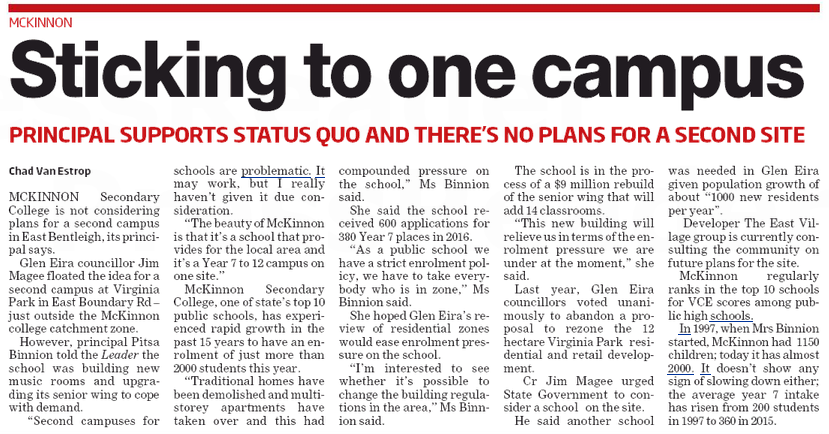
Council’s record with GESAC, Caulfield Park pavilion, and countless other major works has one thing in common – the doubling of costs! GESAC was supposed to be roughly around $28m. We estimate that it is in the realm of $50 to $60m. The same with other projects. Now we have the Booran Road Reservoir.

In 2008, the estimated cost was ‘over $5m’. (Minutes of 1st July, 2008). Admittedly costs have gone up over time and there are always unexpected expenses. However, should this mean a doubling of expenditure? What does this say about ‘business plans’ and sound management and oversight?

Given the way in which council provides data it is extremely difficult to come up with figures for how much this development is actually costing ratepayers. What we do know is what is contained in the minutes and to put it simply – these figures do not add up!

In 2011 the budget stated – Booran Road Reservoir – The SRP allows for the reinstatement and redevelopment of the Booran Road Reservoir Site – $4m in 2017-2018 and $3.5m in 2018-2019. (minutes of 27th April 2011) That’s $7.5 million.

In 2013 the figures became – reinstatement and redevelopment of the Booran Road Reservoir Site as Public Open space – $5m in 2015-2016 and $4.5m in 2016-2017 (minutes of June 25, 2013) – $9.5million

In 2015 this became – Booran Reserve – reinstatement and redevelopment of the former Glen Huntly Reservoir Site as Public Open Space $4.84m in 2015- 2016 and $3.93m in 2016-17 (includes State Government funding of $585k). (Minutes of 23rd June 2015)

In the meantime of course, there has been massive expenditure on a variety of tenders and other ‘expenses’. Here are some – all taken from the minutes.

  • Booran Road Reservoir site – allow $50k for site investigation works. (Minutes of 1st July 2008)
  • Booran Road Reservoir Consultation and Master Plan Development $60k AND Feasibility Study – Booran Reservoir – $15K (minutes of 28th June 2011)
  • BOORAN RESERVOIR SOIL CONTAMINATION $60,000 (minutes of 30th August 2011)
  • BOORAN ROAD RESERVOIR COMMUNITY CONSULTATION AND MASTER PLAN DEVELOPMENT – $200,000 (minutes of  2nd September 2014)

Tenders are also interesting – especially toilets:

  • Toilets – ($473,000.00 including GST (1st September 2015)
  • electricity station – $50,215 (Inc. GST) (MINUTES 21ST September 2015)
  • The result of this tender was not published in the minutes – Supply and Installation of two double Automated Toilets – $400,000  (MINUTES OF JUNE 30TH, 2015)
  • Demolition of Sections of Existing Concrete Walls, Floor Slabs, Earth Embankments andAssociated Works for an amount of $838,504.32 exclusive of GST ($922,354.75 including GST). (23rd September 2014)
  • More toilets – $359,693.40
  • Playgrounds – ($1,886,475.80 including GST) – 11th August 2015
  • The Water Play Feature – $1.9 m24th November 2015

But the best is what’s in the current agenda – an estimated $4.01 million for ‘lighting and landscape works’ with only 3 selection criteria!!!! Please note that other councils often have 6 or 7 selection criteria.

Adding up these figures, the grand total is well and truly above $9 million ($7m alone for 2015/6) and we expect plenty more to be spent.  Yes, there might be ‘carry forwards’ but this still does not equate with what the budget figures state. Thus, the question of ‘how much is this really costing’ is worth asking – especially in an era of supposed ‘cost cutting’ and ratecapping!

CLICK TO ENLARGE

PS: Here are some of the latest designs

ve

mckz

Tonight was the first of the 5 ‘community forums’ on the Planning Scheme review. About 30 residents showed up. Magee introduced the evening and then departed due to a prior engagement. He reiterated that Glen Eira has about 1300 people moving into the municipality each year and that they need to live somewhere. VCAT was still his main villain! His ten minute introduction was followed by another ten minute introduction by a ‘facilitator’ hired by council.

Residents were seated at tables with a council planner assigned to each table and a scribe given the task of recording people’s responses to the set questions from the discussion paper. At the conclusion of ten minutes for each theme, the elected scribe reported back to the entire gathering.

The following proposals were repeated several times and from most of the groups:

  • The need for structure planning
  • The need for tree protection
  • The need for parking precinct plans
  • The need for preferred character statements
  • The need to curb overdevelopment
  • The need for a full heritage review
  • The need for policies with more ‘bite’
  • The need for greater environmental considerations in terms of building design and vegetation
  • The need to protect local shopping strips
  • The need to review the zones and schedules
  • The need for height limits overall
  • The need for developers to pay for parking waivers and infrastructure

Sadly, the opportunity to ask questions and receive responses that the entire audience could hear, was not provided. It was clear that the focus was to be on the set questions from the discussion paper, rather than an open and free discussion. When one resident towards the end interrupted the facilitator as she was summing up and asked why no forum was scheduled for Bentleigh, the response was that council could not find a venue! We should also point out, that if council was really determined to engage with the community, then surely 6pm is not the ideal time! And finally, we ask, is it sheer coincidence that the forum scheduled for Carnegie, is to be held so late in the piece (25th May), with only 6 days left before submissions close?

PS: this is why the above recommendations are crucial

Untitled

Activity Centres & Structure Plans

State governments of all persuasions have encouraged and endorsed councils’ implementation of structure plans. Here’s why:

Structure plans provide the foundation for activity centres change by defining the preferred direction of future growth and articulating how this change will be managed.

Structure plans will guide the major changes to land use, built form and public spaces that together can achieve economic, social and environmental objectives for the centre. To encourage development within centres, government policy encourages local governments to review the purpose and function of individual centres and to revise local planning policies through a program of structure planning for each of their activity centres. (Source: http://www.dtpli.vic.gov.au/planning/urban-design-and-development/Activity-Centres/structureplanning)

Stonnington goes further –

A structure plan is a planning tool that sets out a vision for the future development of a place. It establishes a planning and management framework to guide development and land-use change and aims to achieve environmental, social and economic objectives.

A structure plan takes into account all of the issues affecting an area, including its buildings and spaces, land uses, activities and transport. An essential aspect of the structure planning process is feedback from the community on how the area should evolve. An important phase of the structure planning process requires consultation with the community, local residents, traders and the development industry to determine the best outcome for the centre. Each structure plan will require consultation. (Source: http://www.stonnington.vic.gov.au/Vision/Strategic-Planning/Structure-Plans-and-Urban-Frameworks/Structure-Plans-and-Urban-Design-Frameworks)

Glen Eira does not have structure plans whilst every other council in the metropolitan area does. Residents have never been provided with an adequate explanation as to why not. Yet we find this paragraph in the current discussion paper on Theme 2 – Urban Design in Activity Centres –

Guidance for development in these areas can include local policies, structure plans, urban design frameworks, zones, and overlay controls. Currently, Glen Eira utilises a combination of zoning and local policies to outline the preferred planning outcomes for its activity centres.High-rise development in commercial zones has recently been raised as a concern as prescriptive height limits do not apply at present.

Readers should also note that:

  • Urban design frameworks do not exist.
  • Design and Development overlays of note do not exist
  • The only ‘overlays’ in activity centres are student parking, and some for flooding and heritage. Yet, in their wisdom, council still decided that some heritage areas should be included in Residential Growth Zones (ie in Bentleigh).

As far as ‘preferred planning outcomes’ goes, all that the planning scheme contains for its major activity centres of Bentleigh, Elsternwick and Carnegie, are ill-defined, nebulous and contradictory statements. For example – readers should ask themselves what the following means, when no definitions, or precise criteria  are provided.

BENTLEIGH

  • Where opportunities exist, a range of housing types be promoted at increased densities.
  • Where opportunities exist, medium density housing be encouraged in the residential areas surrounding the centre.
  • The managed change of the neighbourhood character of these areas be encouraged.

CARNEGIE

  • Encourage higher-density residential development.
  • Increased density residential developments be encouraged.
  • The managed change of the neighbourhood character be encouraged.

ELSTERNWICK

  • A multi-storey car park may be developed within the existing Coles supermarket car parking area if sympathetically designed to complement the surrounding built form.
  • All developments provide adequate off street parking to protect the amenity of the residents.
  • New developments provide an appropriate interface to adjacent valued community assets such as the churches
  • This precinct be encouraged as an area for higher density development at heights compatible with adjacent buildings.

The height of residential developments be determined by:

  •  Site context, including the scale and character of surrounding development.
  • Site characteristics, including area, dimensions, orientation and topography.
  • Existing development on the site, including height, bulk and site coverage.

Returning to the discussion paper, we find the most extraordinary sentence:

This (structure plans) can offer certainty for residents and developers alike but takes time to implement due to the complexity of research required.

Should we interpret this as an admission that because something is ‘complex’ that it is beyond the capability of council administration?  And if it does ‘take time’, then council has had 17 years to get its act together and produce some decent planning.

Here are some questions that residents should consider asking their representatives:

  • Is council contemplating introducing height limits on commercial areas only in the major activity centres of Bentleigh, Elsternwick, and Carnegie? Will council introduce height limits on commercial sites in its Neighbourhood Centres such as Bentleigh East, McKinnon, Ormond, Murrumbeena, Caulfield North, Glen Huntly, etc?
  • Why has council refused to introduce structure planning and will they begin this process now?
  • Why are heritage areas zoned as Residential Growth zones in Bentleigh, when the government’s practice notes clearly state that such areas should be excluded from the RGZ?

PREFERRED CHARACTER STATEMENTS

Part of any planning scheme review is the imperative to locate any gaps or deficiencies in the scheme and to plug such holes. Councils generally approach this task by diligently analysing VCAT decisions and determining the grounds that VCAT stated in rejecting council positions. The next step is to return to the planning scheme and determine how it can be bolstered to ensure that the grounds available to VCAT are closed off or at the very least, made far more difficult to ignore.

Needless to say, there is nothing in the current Discussion Paper which provides even a hint as to what the ‘problems’ might be. Yet, decision after decision makes it absolutely clear – the failure of council to provide any statement as to ‘preferred neighbourhood character’ in housing diversity (ie GRZ, RGZ) and totally inadequate ‘policy’ in minimal change (NRZ) areas – where ‘waffle’ replaces fine grained statements.

Yes, we repeat! Even large areas within the Neighbourhood Residential Zones are in the same boat as residents living in GRZ or RGZ zones.

Here are two recent VCAT decisions for developments in the so called ‘protected’ areas of Neighbourhood Residential Zones. Some areas have council’s version of ‘preferred character statements’ which amount to nothing more than waffly, motherhood pronouncements, whilst other areas in the NRZ do NOT HAVE even this pretence of such a statement.

The Council’s concern also relies on a misplaced emphasis on preferred character rather than existing (or prevailing) character. It is correct that the minimal change area policy has a specific objective relating to preferred character. However, there is no formal statement of preferred character in or under the scheme for the relevant character precinct in which the land is located. The objective relating to preferred character is to ‘encourage development that is responsive to its site and context, integrates with and enhances the prevailing neighbourhood character. (http://www.austlii.edu.au/au/cases/vic/VCAT/2016/306.html

The Glen Eira Planning Scheme does not include a preferred neighbourhood character statement for this area, and the Clause 22.08 local policy broadly encourages dual occupancy developments in this location in a side-by-side layout, provided that they respect the existing neighbourhood character of the area.

http://www.austlii.edu.au/au/cases/vic/VCAT/2015/870.html

Thus, further question that residents should consider asking their elected representatives are:

·       What gaps in the Planning Scheme has VCAT identified through its decisions? Will council address each and every one of these gaps?

·       Will council introduce preferred character statements for all of Glen Eira that are detailed, specific, and work to ensure that neighbourhood character is protected? If not, why not?

Theme 1 of council’s Discussion Paper focuses on the Municipal Strategic Statement (MSS). This is supposed to outline the ‘vision’ and the policies that will enable the achievement of this ‘vision’. Much of the MSS is ridiculously out of date. A total rewrite is required especially when figures from the 1996 Census are sprinkled throughout this section, or the so-called Community Plan of 2001-2004 provides the basis for planning.

Of greater concern however are the Objectives and the Strategies which are supposed to implement these objectives. There is a total disconnect between what council purportedly aspires to, and how local policies can achieve such objectives. In many cases there are no policies that are in any shape or form available to support the stated aims.

Here is a limited list of objectives taken verbatim from the MSS.

Facilitate high quality urban design and architecture that will enhance neighbourhood character.

Question: how can ‘high quality urban design’ be ‘facilitated’ when there are no urban design frameworks?

Identify a preferred future character for housing diversity areas.

Question: how many more VCAT permits will council allow before it ensures that housing diversity areas do have preferred character statements and thus closes off this loophole so well exploited by developers?

Encourage the retention of existing vegetation, in particular vegetation and trees which contribute to the City’s tree canopy.

Question: how can council achieve this objective without a tree protection policy?

Ensure residential development in commercial areas does not contribute to traffic and car parking problems.

Question: When will council introduce decent Parking Precinct Plans and stop agreeing to car parking waivers?

Ensure that where new development places an increased burden on infrastructure it contributes to the upgrading of infrastructure

Question: How can this objective be met when council has removed its development contributions levy from the planning scheme?

It is all very well to have grandiose statements in the MSS. It is another matter entirely to ensure that there are policies within the planning scheme that will have the legal weight to bring these aims to fruition. As we’ve stated, in Glen Eira, there is not only a lack of policy, but a total disconnect between aims, objectives, and strategy. Thus, the answer to council’s question –‘Are there additional policies that should be included in the Planning Scheme’ – is a resounding ‘yes’!

2

Untitled

The opening few pages of council’s Discussion Paper on the Planning Scheme Review correctly state that:

  • There has been a dramatic increase in the number of ‘mid to high rise’ apartment blocks built in middle ring suburbs such as Glen Eira
  • That population growth in Glen Eira is anticipated to require 12,000 new ‘households’ up to and including 2031. This figure is calculated from 2011 according to Vic Future 2015 and not 2016 as implied. That means that Glen Eira needs an average of 600 net new dwellings per year to meet its ‘quota’.

What the Discussion Paper DOES NOT REVEAL and is essential for a complete understanding of what is happening in Glen Eira due to the Planning Scheme and the zoning, is –

  • that building approvals are approaching 2000 new dwellings per year. Hence a 300+% increase on what is deemed as necessary to meet demand.
  • Building approvals of course, do not take into account the number of planning permits granted and these figures have also gone through the roof since the introduction of the zones. Even if only 50% of these planning permits are acted upon and construction completed by 2031, we estimate the number of net new dwellings per year to be in the vicinity of 2,500 new dwellings given current trends.
  • Council does not reveal that since the introduction of the zones close to 5000 planning approvals for net new dwellings have been granted. Thus, apart from the 300% increase per year, Glen Eira will meet its nominal ‘quota’ not in 2031 but more likely in 2020 at this rate!

Council provides no figures that enable comparisons with other neighbouring councils. Residents have no idea as to building activity in these other municipalities. No comparisons are provided on number of new houses built compared to number of apartment blocks; no comparisons in terms of ‘density’ and what this ‘building boom’ does to overall density and impacts on open space. This is significant since Glen Eira with its meagre 38+ square kilometres has one of the highest population densities in the state. The only council with a higher population density is Port Phillip – but this council is unique in terms of its Capital Zone Status, its ‘inner ring’ categorisation, the Docklands, etc., and its large tourist and commercial centres.

The table presented below is worth considering in our view. It reveals how Glen Eira compares with its neighbours in the Southern Region and elsewhere in terms of building approvals for the six months from July 2015 to December 2015. The stats come from the Australian Bureau of Statistics published in early 2016.

COUNCIL DENSITY PER SQK SIZE – SQK BUILDING APPROVALS FOR HOUSES BUILDING APPROVALS FOR UNITS TOTAL NEW DWELLINGS
GLEN EIRA 3385 38.7 198 741 942
BAYSIDE 2680 36.0 199 160 375
CARDINIA 57.92 1280.6 812 74 888
CASEY 615.72 409.9 1867 161 2041
FRANKSTON 1032 131.0 163 93 259
DANDENONG 1627 36.26 289 220 514
KINGSTON 1479.4 91.0 206 217 425
MORNINGTON 200.09 518.23 483 252 738
MORELAND 2887 51.0 240 858 1120
DAREBIN 2719 53.0 167 820 995
GEELONG 177.64 1247 1105 111 1222
HUME 332.5 504.0 1133 239 1372
MARIBYRNONG 2458 31.2 99 1339 1441
MELTON 536 527.3 894 153 1047
PORT PHILLIP 4871 20.62 27 1176 1217
WHITEHORSE 2365 64.0 296 1050 1348


In Glen Eira, the relationship between single house replacements and multi unit development is around 1:74. That means that for every single new house built, there are 74 apartments built. With just under 39 square km, and no open space to speak of density, infrastructure, traffic, will inevitably be impacted upon.

So what does the Discussion Paper propose, or even ask, in response to these trends? What can the Planning Scheme do to halt the further erosion of residential amenity? If we are to go on the questions proposed it would seem that very little can be done. We do not agree and feature some preliminary questions below that residents might like to consider asking at the forums. We welcome any other suggestions that readers would like to proffer.

  • Will council be introducing any Environmental Sustainability or Water Sensitive Urban Design policies into its planning scheme as Bayside, Yarra, Stonnington, Whitehorse and other councils have done? If not, why not?
  • Will Council be introducing Parking Precinct Overlays into its RGZ and GRZ zoned areas to manage traffic in its centres? If not, why not? Will Council be creating the long promised Parking Precinct Plan for its activity centres? If not, why not?
  • Will Council be introducing any tree protection measures into its Planning Scheme in order to halt moonscaping as other councils have done? If not, why not?

Given recent events, we thought it would be illuminating to revisit one of our earlier posts (June 19th, 2013) so that residents may gauge for themselves how much credibility to assign to anything our councillors say, and especially Hyams. Here is an article from the Leader of that date. The comments for that post are also worth re-reading since time has proven them to be very prescient.

permit

« Previous PageNext Page »