PS: Glen Eira councillors should be exceedingly pleased with themselves. In the space of this year alone (ie January to December) they will have granted permits for 1144 new dwellings. When we consider that only about 2% of applications arrive for Council consideration as opposed to the hired help (ie officers) then councillors are certainly keeping up their end of the bargain. To the best of our knowledge, only one application – Penang St. – has been refused. Thus councillors alone are responsible for a doubling of the average new dwellings per year in Glen Eira! Include what officers rubber stamp and the number is quadrupled at least. None of this of course is the result of the new zoning!!!!!!!!!!
Tuesday night’s council meeting is set down for another marathon and, in line with the usual tactics, major development applications are all crammed into this one single meeting – regardless of the fact that some applications go back as far as the 17th July 2014. So much for the 60 day decision time limit!
We wish to draw readers’ attention to the following:
- Officers recommend another 149 dwellings to be granted permits
- The trend of minimal notifications continues
- Comments on internal amenity are practically non-existent. Where they do occur, readers will be amused to note that balconies count as part of ‘internal amenity’.
- Not all applications provide information on the number of single bedroom and two bedroom dwellings. Consistency is non-existent throughout the reports.
- Officer comments are repeatedly bereft of detail, statistics, or in fact logical consistency. Instead residents are assailed with waffle, and unsubstantiated claim after claim.
- Waiving of car parking or loading bay requirements continues unabated.
We regard each and every one of these reports as not only sub-standard but more importantly, non informative and certainly not the basis upon which informed decision making should take place!
Here are some of the ‘low lights’ and please note the insipid and facile jargon used repeatedly –
14-18 Bent Street BENTLEIGH – Construction of a four (4) storey building comprising of 55 dwellings (above basement car parking). 19 properties notified, 5 objections.
The proposed building has a street setback of 6.4 metres at ground floor, gradually increasing to 9.8 metres at the uppermost floor. Greater street setbacks will be required to ensure that the development maintains the built form rhythm of Bent Street.
Internal Amenity
To ensure the usability of balconies, a condition will require 8m² for each balcony that is clear of obstructions such as air conditioners.
Each unit is afforded storage space within the basement level. However, the storage capacity is below the required 6 cubic metres. A condition of approval will be require 6 cubic metres of storage space for each dwelling.
A number of ensuites and bathrooms are not afforded any daylight access and are sited internally within the building envelope. Where opportunities exist, a condition of permit will be included within the Appendix to require the provision of a skylight to improve the internal amenity of the dwellings.
++++++
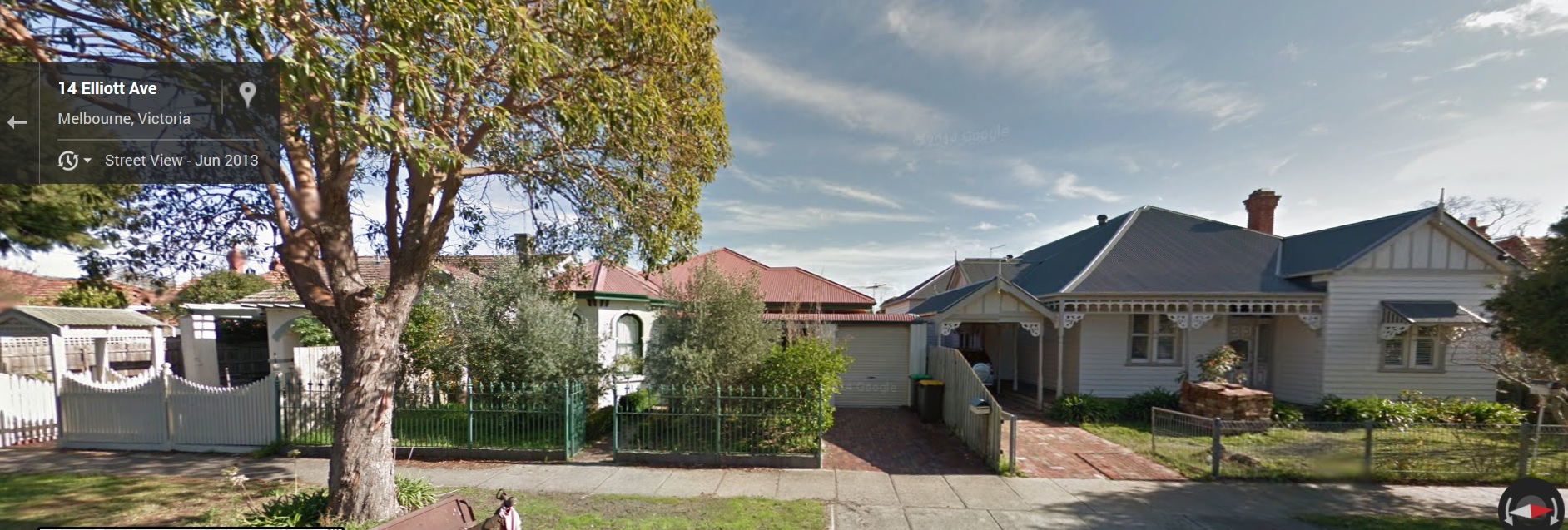
14-16 Elliott Avenue – 4 storey, 21 dwellings, reduction in visitor car parking . 11 properties notified, 10 objections
Availability of on street parking, based on the conclusions of the parking and
traffic report prepared by the permit applicant’s traffic engineer…….
++++++
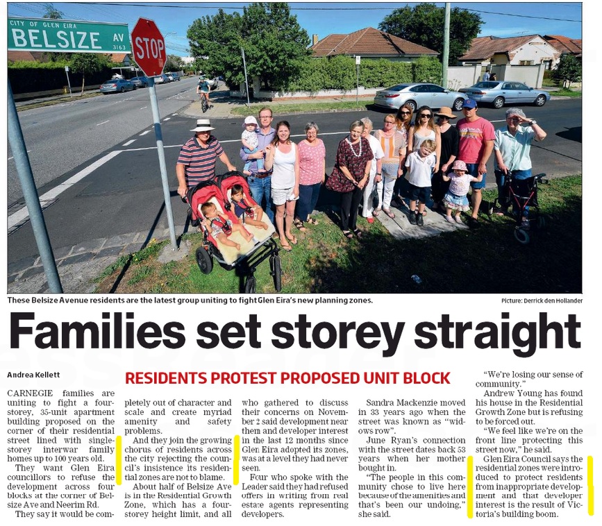
339-341 Neerim Road & 19-21 Belsize Avenue CARNEGIE – 4 storey, 35 dwellings. Officer recommendation – 30 dwellings and increase in visitor parking to 4 spaces. (note 6 is the standard for 30 dwellings!) (20 properties notified – 35 objections)
A recommended condition is included to increase the front setback by 1.5m to bring the proposal closer to compliance with ResCode and improve the streetscape appearance of the proposal.
The recommended increased setbacks will reduce the overshadowing impacts and allow more daylight and sunlight to reach the adjoining dwellings and their rear yards.
Council’s Transport Planning Department has advised that the increase in traffic generated by the proposal is unlikely to have any significant adverse impact on the current operation of Belsize Avenue or the surrounding road network.
++++++
1A Orrong Crescent and 632A Inkerman Road CAULFIELD NORTH – (19/8/2014) A four (4) storey building comprising three (3) shops and eighteen (18) dwellings above a basement car park and reduction of parking requirements and waiver of loading bay requirements. 13 properties notified, 10 objections. Recommendation is for 2 visitor car parks – standards require 3.
The subject site is zoned Commercial 1. All surrounding properties are located within the Neighbourhood Residential Zone…..Subject to conditions, the proposed development is an acceptable response to the zoning, the site context, and will achieve an acceptable degree of fit whilst ensuring the amenity of the adjoining and nearby residential properties in the Neighbourhood Residential Zone.
Given the Commercial Zoning and presence of only one residential abuttal, it is considered that in principal a four storey building is acceptable on the site;
The architectural style of the proposal is considered acceptable as the façade incorporates a reasonable level of visual interest through articulation of the elevations using balconies, architectural features and a contemporary style of architecture. Dwellings at ground floor fronting Orrong Crescent will provide an appropriate transition to the surrounding residential properties.
+++++
482-484 North Road ORMOND – (17/7/2014) A four (4) storey building comprising twenty-four dwellings (including a caretakers dwelling). Recommendation – 4 storey, 21 dwellings, Car parking at a rate of one per dwelling, 4 visitor parking spaces and 1 shop/caretakers dwelling parking space. 14 properties notified and 6 objections.
Given the context and emerging character of North Road, it is considered that a four storey building is generally acceptable on the subject site.The proposal will be taller than the adjoining single storey dwellings to the west but consistent with other four storey buildings in the area.
Council is aware that a tree was removed from the subject site prior to the lodgement of the application. Councils Landscape Assessment Officer has advised the removal of this tree is of no real concern. Future landscaping can be provided around the building. This is recommended
The most sensitive interface is to the south. This property contains a single storey dwelling with a driveway along its northern boundary. Whilst it is within the General Residential Zone, Anthony Street is also within the Ormond Precinct Heritage Overlay which could reduce future development expectations.
With this in mind, additional setbacks from the south are recommended as a condition of approval to respond to the interface. Inevitably the proposed building will continue to be visible from Anthony Street (and the surrounding area), however additional setbacks proposed will ensure an appropriate transition is achieved.
++++++
477 South Road BENTLEIGH VIC 3204 – A four storey building with five dwellings and a shop. 7 properties notified and 2 objections. Recommendation – reduction of the car parking requirements for the shop use and waiver of loading bay requirements.
++++++
188-190 Tucker Road, BENTLEIGH – A 142 place Child Care Centre with a basement car park. Recommendation – 132 children. 14 properties notified, 15 objections and petition of 88 signatures.
By encouraging corner sites on secondary roads as preferred locations, policy anticipates side street access is likely and reasonable.
Familiarity of parents with the basement would occur over time and would be a normal part of orientation and induction for new parents. A Parking Management Plan which is recommended as a condition will require the education of parents and staff of the centre about the basement.
Council’s Transport Planners have indicated that the traffic generated by the proposal would have a minimal impact on both Tucker Road and Ellen Street.
Σ An average peak hour rate of 0.91 trips per child is estimated which accords with the rate prescribed in the Policy. Whilst this represents a noticeable increase in traffic volumes, it will not have a significant adverse impact on the operation of the local road network.