Hyams moved an amendment to accept the recommendations plus, to ‘include meaningful engagement’ with the community to be part of and ‘not following’ the draft structure plan. Taylor seconded.
HYAMS: began by saying that even though the recommendations as ‘set out in the report’ are ‘intended to be pretty thorough’ it recommends community consultation ‘on the master plan’ or structure plan ‘afterwards’. ‘My view’ is that ‘residents’ should have a say in the drafting of the structure plan. Said that ‘this would have happened anyway’ because that was what ‘council intended to do’ and ‘it’s better to have that clarified in the report‘. Called this a ‘great opportunity’ for Glen Eira because it is a ‘massive site’ and they intend to use this as an ’employment hub’ with retail plus residential. That’s ‘what we’re allowed’ by the planning scheme. Hyams went over past history – the first amendment which rezoned part to Commercial and the second application for amendment which proposed many residential premises and a ‘supermarket’ and council thought this wasn’t ‘appropriate’ for the site because ‘it didn’t do what we wanted it to’ as an ’employment hub’ and also ‘competed too much’ with other retail in the area. ‘So what we’re looking for here is something along the first lines’ (ie employment hub) but it’s a ‘huge site’ with many ‘possibilities, so it will be very complicated’ and that’s why the VPA is being brought in ‘to assist us’. Said that ‘all final decisions’ will ‘rest with council’. ‘We will direct the consultation, we will still make the decision’ but the VPA ‘will be using their greater expertise’ in ‘producing the best outcome for Glen Eira’. Apart from the consultation ‘which will be going on throughout’ the applicant can still put in their amendment planning scheme application. This will go through the ‘normal processes’ of submissions, panel if required, and ministerial approval. Summed up by saying that right through the process ‘there will be a great opportunity’ for people to ‘have input all the way through’. ‘Noted’ that the ‘current landowner has been a lot more consultative’ and ‘friendly’.
TAYLOR: began by saying that it is ‘absolutely a given’ that there is ‘full and transparent consultation’. Wanted to ‘reassure’ those people who had rung her and that it ‘doesn’t hurt to spell out’ the ‘continuous involvement’ of the community. ‘We genuinely want you to have a say’. ‘We are all members of this community’ and everyone has ‘something to offer here’.
ATHANOSOPOULOS: said that ‘everyone agreed’ that they need to ‘establish some key partnerships’ and this is ‘just an example of us doing that’. Said that if they are going ‘to deliver’ a ‘great’ development then they need to ‘consider the residents’, ‘housing responsibilities’, ‘educational responsibilities’ and overall ‘responsibilities for the whole of Glen Eira’. Said the developer’s ‘initial process’ was ‘railroaded through’ and they’ve realised they haven’t done a ‘good job and come back to us’ and ‘engaged with the community’ plus traders and others. Thought it was important that council establish partnerships ‘especially with resources being limited’. Vital that council be the ‘leader’ on this. Said that the ‘community has been screaming out’ about the site and this is the ‘first opportunity’ ‘for us to actually go ahead with this’. Said the most important point is that he has put forward a ‘recommendation’ based on a resident’s comment to ‘establish’ some form of community group ‘that does feed us, the council information as this project goes on’. The makeup of the group is ‘unknown, maybe a couple of residents’, ‘community leaders’, etc. This will ‘bounce ideas’ and ‘get a feel for what the community wants’.Said it was a good ‘opportunity for us to establish something like this’.
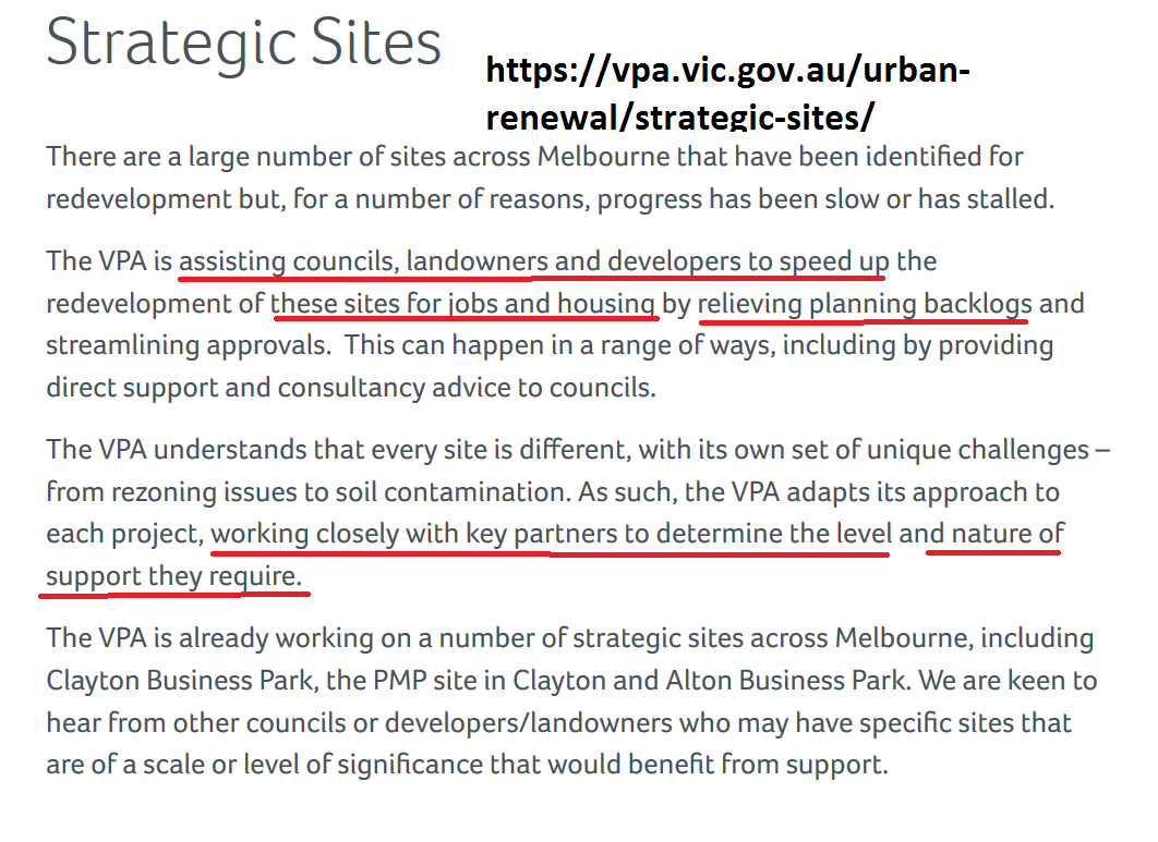
DELAHUNTY: asked the CEO to ‘explain’ what the VPA was.
MCKENZIE: said this is a recent extension of the Metropolitan Planning Authority and has a ‘role in providing guidance’ for major developments especially in new suburbs and ‘in creating jobs’. Council has ‘already committed to’ a huge program of strategic work and by forging this ‘partnership’ this ‘enables us to carry on this program of work in parallel’ with the other projects on structure planning. This ‘doesn’t derail’ the existing program but allows them to ‘carry on’ and to ‘deliver a cost saving to council’ and to ‘draw on specialist expertise’ – particularly on retail development and development contributions. ‘Council would retain the decision making role’ and ‘lead and take ownership’ of the ‘community engagement element of the project’.
MAGEE: said this has ‘come a long, long way’ and now there is a ‘far better approach’ than what happened in 2013. In 2013 one of the recommendations was to rezone all the site to Commercial and without community consultation. Said that council learnt of this via the department and the local minister and local member of the time supported this. The proposed structure planning now ‘is certainly the right way to go’ and ‘the approach now (by the developer) is totally different’. They have held a ‘number of community consultation meetings’, ‘poorly attended, but that’s our fault, not theirs’. Said that the ‘Minister likes the VPA’. ‘They are ‘experts in doing structure plans’. Thought that an application would come in this year for a ‘planning scheme amendment’ which could be ‘simple’ and asking for the ‘whole site’ to be Commercial 1. With Commercial you can ‘put residential, commercial and mixed uses in’. The VPA will ‘assist council in putting together a structure plan’ and at ‘all stages will talk with our community’. The community has to ‘understand’ what is going to happen on the biggest site where ‘we all live’. ‘This is a huge site and it has huge implications’ so even though ‘I welcome the new approach I’m still wary of what happened in 2013’. ‘Once this decision is made it will never be reversed’. He hopes that as councillors ‘we will drive past something that we are proud of’. ‘Concerned that we cannot get this wrong’. Welcomed the VPA involvement and community consultation but ‘don’t come at the end and say you don’t like what’s been written’. ‘Don’t say you didn’t get an opportunity’ to have a say.
DELAHUNTY: said she ‘welcomed this’ and it ‘allows us to get on’ with the program of planning and ‘adds to the resources of the council’. Last effort had mistakes by applicant and ‘this allows us to better formulate community engagement’ and the suggested reference group is ‘an interface between council and the community, not between the community and the applicant’ and ‘does add to our ability to take different views’. ‘This is worth being done properly’ and is exactly what council should be doing in ‘bringing in extra resources’.
MOTION PUT AND CARRIED UNANIMOUSLY