GE Open Space


The image above comes from Council’s summary of community responses to the Bentleigh ‘shopping strip’ online survey. According to the ‘facts’ presented here we are meant to believe that 65% of respondents are in favour of ‘private development’ (whatever that means!) – but with some constraints on height and ‘character’. Please note that of the valid 248 comments included in the document, the claim that 65% are ‘supportive’ does indeed represent an entire work of fiction. What is most disappointing about this report is:

  • The failure to acknowledge the countless comments that specifically referred to overdevelopment in the various side streets of Bentleigh – ie the damage done via the zones
  • The exclusive emphases on the ‘survey’ comments rather than the opinions expressed via the forum PLUS the apparent ‘editing’ of the forum comments themselves – ie not every comment made online is included in the resulting ‘summary’. Here is one example of what’s been omitted – The critical and major issue is the urgent implementation of height and appropriate building form controls. Interim measures are required immediately to ensure a planned future for the shopping precinct. The inappropriate and unplanned overdevelopment must be stopped now to ensure that structure planning results in long term plan
  • The total inconsistency in the reporting across all suburbs. Surely a report on community responses to one issue should include identical categories in the respective pie charts?
  • Could this possibly be another example of ‘community consultation’ designed to ‘endorse’ the decisions that have already been made behind closed doors?

Presented below are the pages that are council’s version of the online forum comments plus another graphic displaying what has been happening south of Centre Road Bentleigh since the introduction of the zones!

Council’s recent release of documents related to its ‘structure planning’ must, in our view, be treated with a huge grain of salt. This is the first in a series of posts analysing what has been placed in front of residents and how valid, accurate, and transparent these documents really are. Are we again being taken for a ride via data that are highly questionable and manipulated to present already determined decisions?

The first document is called ‘Activity Centres Snapshot: February 2017’. It purports to be ‘based on similar studies carried out by Melbourne City Council’ in its Places for People and Local Liveability 2015 Study. (uploaded HERE). The aim is to ‘provide a more comprehensive understanding of how the city performs for everyday people’. Yet, when both of these documents are compared, the Glen Eira version is anything but ‘comprehensive’. For starters we are told that:

  • All data used in this document is current (February 2017) except for residential and employment population data, which is taken from the Census carried out by the Australian Bureau of Statistics in 2011. How much credence should then be placed on this ‘snapshot’, especially given the rate of development since 2011?
  • The land uses were determined using Council’s internal database and does not include residential land within the study areas. How on earth any study can ignore ‘residential’ is simply mind boggling! Or is this simply more confirmation of the fact that council is focusing exclusively on the single street shopping strips themselves and not the zones that have blighted countless people’s lives?
  • Then of course, there is this wonderful ‘escape clause’ – Disclaimer: this document is provided for information purposes and does not claim to be complete. Although due diligence has been applied to ensure that all information contained in this document is accurate, it cannot be guaranteed that this document is without errors or omissions. Why publish anything if its accuracy and integrity cannot be assured?

We’ve drawn up a table below which illustrates just some of the differences between the Glen Eira version of good planning and what the Melbourne City Council included in their study. To therefore claim that this piece of paper represents a ‘snapshot’ of what is happening in Glen Eira, and is the basis upon which to plan for the future, is not only ludicrous, but deliberately misleading and invalid.

MELBOURNE CITY COUNCI1

Compounding all of the above, we then have neat little maps of the various areas under consideration – with no explanation, no criteria, and again, lines drawn on a map. The City of Melbourne’s study clearly defined how its various neighbourhood borders were selected –

To understand the Local Liveability 2015 Study area at a local level, 5-minute walking catchments were identified across the study area to effectively act as a sieve and allow for disparate urban geographies and their components to be compared ‘apples for apples’. For greater rigour and to reflect the true local urban conditions, real 5-minute walking catchments were determined rather than standard ‘as-the-crow-flies’ walking radii.
Local Movement as defined by Melbourne then includes ‘Car Spaces Per Employment’, ‘Car Spaces Per Resident’, and the numbers of bus stops, tram stops, etc.  All Glen Eira includes are the latter. As mentioned previously parking does not figure at all. Instead we are presented with nice little maps, that may look ‘professional’ and pretty, but which don’t reveal very much when terms, borders, and important categories are omitted!
The Bentleigh snapshot is typical. Depicted is a huge area that is overwhelmingly ‘residential’ – which we’re told has been excluded. Thus, what knowledge and what kind of basis for future planning can be drawn from this effort? Finally, Melbourne has no qualms in pinpointing areas that are ‘poor’ in terms of ‘liveability’ for its neighbourhood areas. In Glen Eira of course, the category ‘poor’ simply does not exist – everything is ‘great’ or ‘good’!!!!!!!!!

CLICK TO ENLARGE

For all the talk about ‘consultation’ the single thing that residents have been clamouring for over the past few years is being totally ignored – a review of the residential zones.

The image above provides clear, unassailable evidence of how disastrous the implementation and maintaining of the current zoning has been. Please note carefully:

  • The vast majority of development since the introduction of the new zones HAS NOT OCCURRED in those areas zoned as Commercial – which is what the planning scheme states should happen. Instead, street after street has been destroyed because it is zoned as suitable for 4 storey development.
  • Many of these streets are not within cooee of the railway station (circled in red) which is the reason for designating these areas as an ‘activity centre’. They might be 400-600 metres away from the station, but only as the crow flies. Walking distance (ie properties in Mimosa, Beena, etc) would make these sites at least one kilometre from any railway station.
  • Activity centres are also supposed to incorporate community facilities such as open space. The map reveals not a skerrick of nearby open space!
  • Other councils do their structure planning on the basis of recent Housing Strategies. Glen Eira’s fossilised strategy originates from 1998 data. Yet, we now have the spin about structure planning that will extend over the next 10 to 15 years, WITHOUT any new housing strategy!
  • Even Matthew Guy had enough sense in his July 2014 directive to mandate – A planning authority must use a housing strategy to inform the balanced application of the three residential zones. We assume that Guy’s order would presume recent analysis and data, since those councils who chose the option of going to a committee for the implementation of their zones were told that their proposed zoning couldn’t go ahead since their data is too old! Glen Eira as a result has no strategic justification for its implementation of the new zones according to what the committee told numerous other councils!
  • Guy even states – A planning authority must evaluate and monitor the implications of the application of any of the three residential zones within two years of their gazettal into a planning scheme. Planning authorities must specifically assess the affect of the residential zone(s) on housing supply, housing prices, infill development site land prices and the availability of land for infill development but are not limited to those matters. Three and a half years down the track and residents are yet to receive any decent ‘report’ as to the efficacy of all the zones – are they working? Where is development really going? What needs changing? How best to protect residential amenity?
  • Residents also should realise that when Amendment C25, which created the Housing Diversity/Minimal change areas in Glen Eira, the panel appointed to evaluate the amendment clearly saw this as an ‘interim’ measure. The word ‘interim’ was used over 20 times in their resulting panel report. Here is one example of what was stated – The boundaries of the neighbourhood centres identified in the amendment are considered by the panel as interim at best. Thus, we are stuck with ‘interim’ housing diversity borders and for the past 17 years no inclination by Council to do what it promised – ie review the areas and implement controls that will protect residents.

The take home message is that unless these councillors have the courage to admit that disastrous mistakes have been made, the rot will continue until the bottom falls out of the housing market. We simply ask:

  • Why can’t the borders of housing diversity areas be reduced given the fact that instead of the required 600 new dwellings per annum, Glen Eira is now accommodating over 2000 net new dwellings per annum?
  • Why should suburbs such as Ormond have over 40% of its area designated as suitable for 3 storey developments? – especially when large swathes are zoned as heritage?
  • Unless there is a comprehensive review of the zones, then residents have every right to label this council not only as incompetent, but negligent in its duty.
  • Creating structure plans only for the Commercial areas will not solve the problem of street after street being over-run with substandard dog boxes. This isn’t planning. It is cow-towing to the development industry and the refusal to admit that the Newton & Akehurst vision for Glen Eira is a total disaster, especially when residents have had no say in what happened!

As a reminder of the human cost involved, we re-publish an email we received a while back from an Elliott Street resident. It spells out everything that is wrong with planning in Glen Eira –

We live in the house next to the 51 units, 4 storeys, 3-9 Elliott Ave. It is on our north side! We will also be opposite 60 more units in Elliott Ave. Only 6 out of 20 houses left in our part of this small suburban street…… what can we say. We explored all avenues including going to VCAT, employing a Planner for quite a substantial fee. We achieved some minor concessions with shadowing and setbacks. It has been an exhausting process. I wonder if we are completely stupid to continue to stay here after 36 years, enjoying the peace and convenience of living in Carnegie. However, all has changed. The council has won. The peace and joy of living here is shattered. We will stay and see how things pan out. The world is changing at such a rapid pace around us and I’m afraid we’ve lost faith in the Council and its concern for the community. We will look back in a few years time at the implementation of these zones and wonder how it could happen. In a bizarre way it makes me empathise with the first people of our country and the bewilderment of colonisation! Rapid change can leave a community depleted.

A short, preliminary report on last night’s lengthy council meeting.

Item 9.1 (19 storey Kooyong Road application) created a first in Glen Eira. Instead of cramming scores of the public into the chamber, this item was moved into the larger hall with councillors and officers up on the dias and supplied with microphones. As expected, the application was unanimously refused. Delahunty moved an amendment that should the developer decide to go to VCAT, then council would be asking the Minister for Planning to ‘call the application in’. This effectively means that it is the Minister who would, under these circumstances, be making the decision.

Following this item the meeting resumed back in the chamber. Many residents were present to hear the outcome of the parking restriction items – especially those streets around the Caulfield Hospital. In line with previous meetings there was the suspension of standing orders for the gallery to ask questions for 15 minutes. Council and councillors received the most scathing criticism from several people for their failure to consult, to be transparent, and to employ basic common sense. Delahunty did apologise on behalf of council for not consulting when this issue of changing the 2 hour parking layouts occurred. The report and the final decision (to basically do nothing except wait some more) resulted in many residents walking out in disgust.

This issue has now been allowed to continue for at least 9 months. We remind readers that council’s so called ‘policy’ states that parking decisions will be made with a survey of the streets involved. This was not done, and it is not being done now. Please refer to our previous posts for details and how other council approach such issues –

https://gleneira.wordpress.com/2016/07/23/parking-glen-eira-versus-moonee-valley/

and

https://gleneira.wordpress.com/2016/06/20/q-a-2/

For the nth time a request for a report by Taylor on the possibility of community gardens was passed unanimously. Terrific stuff, since this issue has been around since 2003!

We will provide a far more detailed summary of the ‘debates’ in the days ahead.

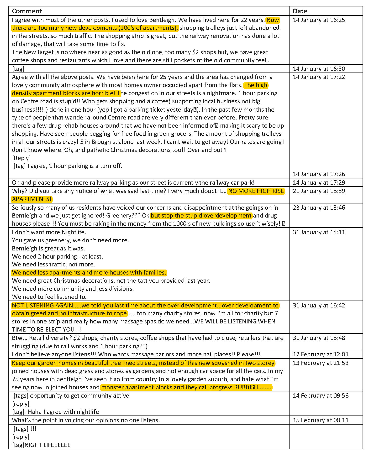
No surprise that the recommendation for the 19 storey Calvary Health application is a refusal. With over 300 formal objections, wide media coverage, Wynne’s  call for Council to ‘get it right’ and the absurdity of what is undoubtedly an ambit claim, council was left with little option.  Trouble is that they have certainly not done residents a favour with the resulting officer’s report. If anything it has handed the developer enough ammunition to turn council into a laughing stock at VCAT.  The report is incompetent, and worse, deliberately misleading! Here’s why!

One of the major reasons for refusal is council’s sudden interest in open space.  We’re told:

The proposal is inconsistent with the City of Glen Eira Open Space Strategy (2014) as: The proposed public open space is of insufficient size to serve the open space needs of the existing and/or future population.

The area is said to be 457 square metres and consequently not large enough for public open space according to this version of reality. Trouble is that the cited Open Space Strategy (OSS), and the Planning Scheme itself says nothing of the sort! Yes, the area is designated as a ‘gap area’ requiring the creation of 2 Small Local Open Space parks. Clause 22.02 states that the size of such parks can be –

oss

Then on page 75 of the OSS we find the following – the area allocated for Small Local open spaces range in size from 300 sqm up to 2,499 sqm and the larger sized spaces can accommodate large canopy trees.

457 square metres is acceptable as public open space according to both the Planning Scheme and the OSS. Further, council suddenly requires that the open space within the development itself has the capacity to not restrict the type of activities that could take place there.

Once again the OSS disagrees with this statement – Minimise duplication of facilities in Small Local open spaces to provide a diversity of recreational activities in open spaces within a local area, e.g. one Small Local open space could be predominantly for play facilities, while the next provides passive seating and open grassed areas. (page 261). In other words, Small Local Open spaces should be treated as unique sites and not be seen as providing options for multiple users and uses.

We also get the demand for a land contribution instead of a cash payment. Whilst the OSS and the Planning Scheme does list council’s preference for a land contribution here, nothing is mandatory. Council ‘may’ request a land contribution if they so wish, or opt for the cash alternative. Which they so happily did with the Virginia Estate amendment that is also listed as suitable for a land contribution. The Gillon Group then revealed that they had offered land but Council insisted on cash. Why the inconsistency is of course the crucial question.

Next there is the question of ‘neighbourhood character’ and council’s ‘policies’. We agree that 19 storeys is a joke. But so is the Planning Scheme and its ‘summary’ of ‘neighbourhood character’ in this area. The fact that any ‘policy’ can be so general, cover such an immense area, and be so wishy-washy, is hardly something that can be relied upon at VCAT!

Character Area 9: Elsternwick – Caulfield South

Character Type: Edwardian / interwar garden suburban base with modern overbuilding (infill development)

This area has an Edwardian and interwar base, with a range of modern overbuilding that creates a mixed character.

Many of the original buildings are constructed of timber.

The area generally has well established gardens with low to medium scale vegetation and regular planting of street trees. Occasionally private gardens include substantial trees and several streets are defined by their avenue planting.

It includes the areas of significant neighbourhood character around St James andRiddell Parades, which is valued for its intact Victorian, Edwardian and Interwarstreetscapes and the strong vegetation quality. (Clause 22.08).

Council also relies on its claims about ‘potential flooding’! Please note:

  • There has been no referral to Melbourne Water
  • There is no Special Building Overlay (SBO) impacting on the site (see image below)
  • All the VCAT member has to do is look at this nonsense and chuck it out. This of course doesn’t explain the fact that given all the flooding since at least 2011, Council has sat back and done bugger all about its SBO’s

sbos

The most important omission in our view is any discussion as to the legal interpretations that should play a large part in any VCAT hearing. Council simply states –

The mandatory height limit applies only to land used as a “Dwelling” or “ResidentialBuilding”. Any other use is not subject to the mandatory height.In this instance, the proposed “Residential Aged Care Facility” building fronting Ludbrook Avenue is the only component of the development which is subject to the mandatory height limit of 9 metres (as the slope of the land is greater than 2.5 degrees). The balance of the development including the nineteen storey building comprising the retired living units is exempt from the mandatory maximum height under the zone.

When 86 so called ‘independent living units’ are crammed into a 19 storey building, and some of these will include 3 bedroom apartments, then surely it is at least worth raising the issue of the status of such a proposal. Could they in any shape or form be considered as ‘dwellings’? If they are ’dwellings’ then they come under the Neighbourhood Residential zone requirements of an 8 metre mandatory height limit! Even the Planning & Environment Act would appear to provide some solace here with its definition of ‘dwelling’. Council simply ignores, or at best, skims over this vital consideration!

“dwelling” means a building that is used, or is intended, adapted or designed for use, as a separate residence, (including kitchen, bathroom and sanitary facilities) for an occupier who has a right to the exclusive use of it …..(planning and environment act, 1987 – definitions Section 46H)

There are plenty of other gaping holes in this Rocky Camera report. Until the competence of the planning department improves dramatically and until officer’s reports are accurate and not misleading, we do not hold out much hope that residents can have any faith in what is presented on the written page!

No need for words. The image says it all – 500 apartments crammed into another handful of streets! And this is without the 7,8, and 9 storey developments waiting in the wings along Centre Road itself. We should also point out that in the majority of these developments, permits were granted by Hyams, Esakoff, Magee and Delahunty who also decided that the community was not worth consulting when they introduced the zones in secret and by stealth!

bentleigh2CLICK TO ENLARGE

Featured below is what has been happening in McKinnon over the past 12 months. We have included several applications that council refused on the assumption that the developer will head to VCAT and instead of demanding 32 units for example, he will ask for 30 units. Given the current planning scheme, history tells us that a second bite at the cherry will be successful.

Please note:

  • The map DOES NOT INCLUDE ALL PERMITS GRANTED SINCE THE ZONES WERE INTRODUCED – ie multi-development in Penang for example, or the current amendment for the corner of Wheatley and McKinnon Road. Nor have we included all of the countless 2 double storey developments in these side streets. We have only concentrated on the past 12 month decision making by council and/or VCAT.
  • We estimate that during this time well over 300 new units will be on the cards – some already built, or in the process of being built. According to the planning scheme, Glen Eira requires only 600 net new dwellings per year to meet population growth. Thus a handful of streets in McKinnon alone have achieved 50% of the stated target for the entire Glen Eira municipality!

Residents should start asking the following questions and demanding concrete and honest answers from their councillors:

  1. What drainage upgrades have occurred in this area since the zones came in?
  2. When will council complete its structure planning for McKinnon and the other neighbourhood centres? Are residents expected to wait 10 to 15 years for this to occur according to the published schedule?
  3. Why is the current consultation on the ‘shopping strips’ emphasising the commercial strips, instead of first informing and then asking direct questions on development, traffic, open space, etc? What role did the consultation committee have in ‘devising’ this current consultation?
  4. How many one bedroom apartments have been built in Glen Eira over the past 3.5 years and how many 3 and 4 bedroom apartments?
  5. How many car parking waivers have been granted to all of the developments shown in the map below – and throughout all of Glen Eira itself?
  6. Why is council steadfastly refusing to review the zones themselves – especially since development is occurring far more in local residential streets zoned General Residential and Residential Growth rather than those areas zoned commercial and mixed use?

mckinnonCLICK TO ENLARGE

From feedback received thus far it appears that resident concerns over the ‘partnership’ between Council, developer and the Victorian Planning Authority, are either not being understood by some councillors, or these concerns are seen as unnecessarily ‘alarmist’.

When the largest ever development is about to occur in Glen Eira, we maintain that community input, from the very start is essential – and not when a draft structure plan has already been devised and to all intents and purposes, probably set in concrete. Any ‘visioning’ must include residents from the start and their involvement must be ongoing throughout the entire project.

In the current agenda papers, one officer report notes the large development at the old Amcor site. Yarra City Council is one model that should be employed for the Virginia Estate development. Yarra had no problem in establishing a ‘reference’ committee right from the start that included 6 community reps. Yarra had no problem in holding regular meetings where residents through their representatives could bring up issues. This is not rocket science. It is the basis of an inclusive council that sees its residents as partners. If the current mantra of council is to be believed then the establishment of such a group is essential!

Here’s the Yarra Council blurb for this committee –

yarra

We’ve also uploaded HERE, the relevant Terms of Reference for the committee.

The plans for the development of Virginia Estate have taken a new turn with the proposed ‘partnership’ between council and the Victorian Planning Authority (VPA). This government body is primarily charged with the responsibility of overseeing ‘urban renewal’, especially in growth areas. They are also involved with large development sites within the metropolitan area such as the Monash/Clayton precinct and now East Village. Here is what their brief states –

redsites

All of the above would indicate that government, developer and council are keen to push through rezoning and amendments that will set the ball rolling for Virginia Estate. There is no doubt that at the latest stated figure of 24 hectares, Virginia Estate will be developed, and a very large component will feature residential accommodation. What concerns us is the role that the community will play in this development. The letter from the VPA, included in the agenda, outlines a brief timetable schedule. Please note carefully the following:

  • The time frame for the ‘delivery’ of a draft structure plan for the site is basically 3 months. Yet, the officer report keeps insisting that this will be part of council’s review of its ‘activity centre strategy’ – not due to be completed until 2018 at the earliest. Thus, what porkies are we being fed?
  • Why aren’t the community involved right from the start instead of having the draft structure plan thrust down their throat and then asked to comment? We all know what this means and how little is changed once the ‘draft’ of anything is completed.
  • Why does the officer report emphasise ‘business’ and ‘residential’ barely rates a mention?

We’ve uploaded the proposed schedule. Clearly discussions between government, developer and council have been ongoing for some time given this timeframe. We’ve also uploaded the full agenda item (HERE) so readers can see for themselves the lack of real detail provided.

vpa

In conclusion, VPA does have a role here and council is undoubtedly better off financially if much of the cost comes out of government and developer coffers. What we are concerned about is the level of genuine consultation with the community and whether development gets the go ahead well and truly before infrastructure, transport, etc. is completed.

There are 3 agenda items down for decision this coming Tuesday which should set alarm bells ringing for residents. In this first post we concentrate on Item 9.3 – Council’s ‘position’ on the Ormond Railway development site.

What is absolutely staggering about this report and its recommendation is that councillors ENDORSE A MANDATORY HEIGHT LIMIT OF 8 STOREYS!

This is staggering for the simple reason that it exceeds the proposed heights of 7 storeys in Carnegie and 5 storeys in Bentleigh that were nominated in the proposed Amendments for these activity centres. Thus we now have the ludicrous situation where a so called ‘neighbourhood centre’ with less shopping areas and surrounded by residential development is okay for 8 storeys and Carnegie and Bentleigh are deemed suitable for lesser height. Unbelievable shonky planning !

What makes matters even worse is that this recommendation by the ‘experts’ is not even in the public domain. Hence we have the situation where residents are denied access to the rationale which would support a recommendation of 8 storeys. So much for transparency and accountability!

Further, we are told in the officer report  that: In order to form the strongest position possible, City Futures (ie Council) have sought an evidence-based approach to inform Council’s position for a preferred maximum building height. And what is this ‘evidence based’ data on? According to the report it consists of the following –

  • Status of centre
  • Precedents
  • Typology
  • Street wall ratio
  • Solar Access
  • Key View lines
  • Transition
  • Connectivity

We posit that none of the above is ‘evidence’ for an 8 storey apartment block. It might as well be 10 or 12 storeys! Nothing here would suggest that the following important issues have been considered – open space, infrastructure, parking/traffic, development in the area, retail business study, etc. etc. If this is the basis upon which such major decisions are being made, then God help us!

Even worse, is that once again there has not been a single round of ‘consultation’ between residents and council on how high anything should be in the municipality! The rhetoric is all about ‘consultation’. Pity that words never seem to match actions and decisions!

pages-from-02-07-2017-agenda

« Previous PageNext Page »