Council has in all probability spent a fortune on consultants. As we’ve stated previously, consultants are basically hired guns. Much depends on their brief and the directions issued to them by council staff. This is made crystal clear in the Introduction to the consultant’s Housing Study. We’re told that the objective is –
To assist in preparing the (activity centre structure planning) strategy, Council has commissioned .id (Informed Decisions) to undertake an analysis of housing consumption patterns and opportunities. It also includes an assessment of centres identified by Council as appropriate for intensification and their potential dwelling capacity
Thus from step one the game is virtually rigged! It is council staff who have decided which areas are ‘appropriate for intensification’, where the borders will now be, and which areas will be upgraded to allow for more intense development – but without providing residents with the necessary logic behind any such decisions nor any data that might justify such decisions.
Not for the first time in this entire structure planning process, have we been provided with consultants’ reports which in many areas are certainly open to question. The latest example(s) come from the Housing Report.
‘NET GAIN’ OF DWELLINGS IN NRZ
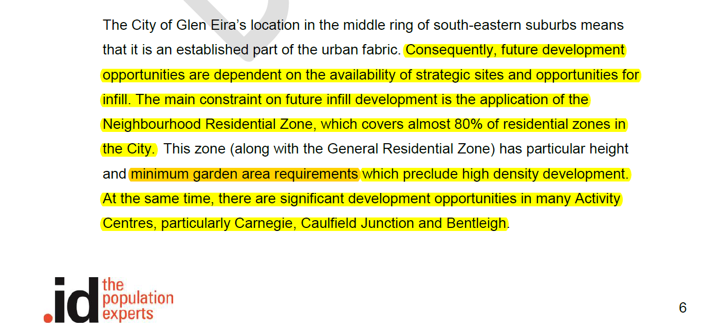
We are told that the report is dated May 2017. That is 2 months after Wynne introduced VC110 which removed the mandatory 2 dwellings per lot in the Neighbourhood Residential Zone. It is therefore fascinating to observe that the Housing Report does not once make specific mention of this fact – although there is reference to the ‘garden requirements’ and height limits.

Why not state the removal of the mandatory 2 dwellings per lot up front? Why not address its potential impact across all of Glen Eira and not just those areas immediately outside the designated activity centres? We proffer the answer that this would cast some serious doubt on the figures provided by the report – even though they are claimed to be ‘conservative’. If there is no limit on the number of dwellings now permissible in NRZ, then that means that infill will in all likelihood be far greater than suggested by the report. If it is therefore greater, then the argument could follow that activity centres do not need to be so gung ho in allowing more development. That in fact much of the current zoning can be reduced and that there certainly is no need to expand the borders of activity centres and rope in more dwellings for greater development.
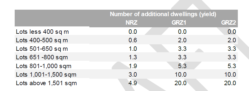
The report goes on to claim that in the NRZ areas there will only be the following number of ‘net gain’ new dwellings –
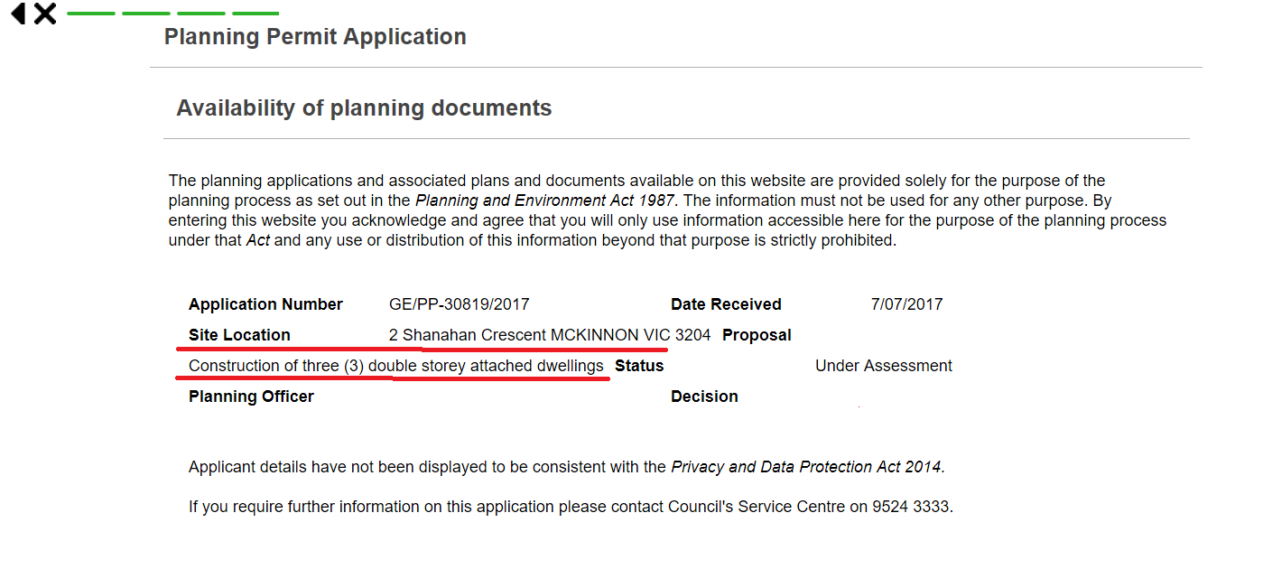
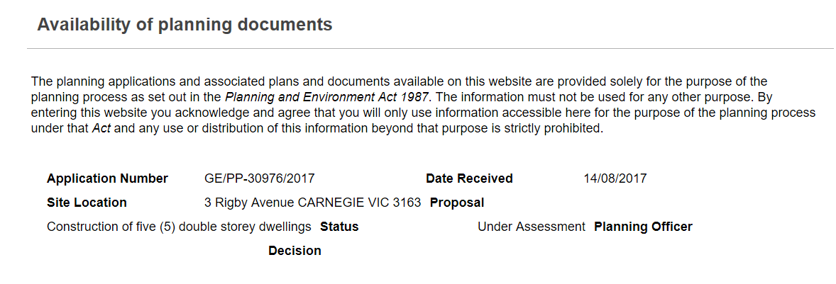
 We now have 10 applications in for multi unit development in NRZ. These applications reveal how suspect the Household predictions are. For example:
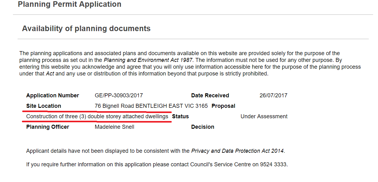
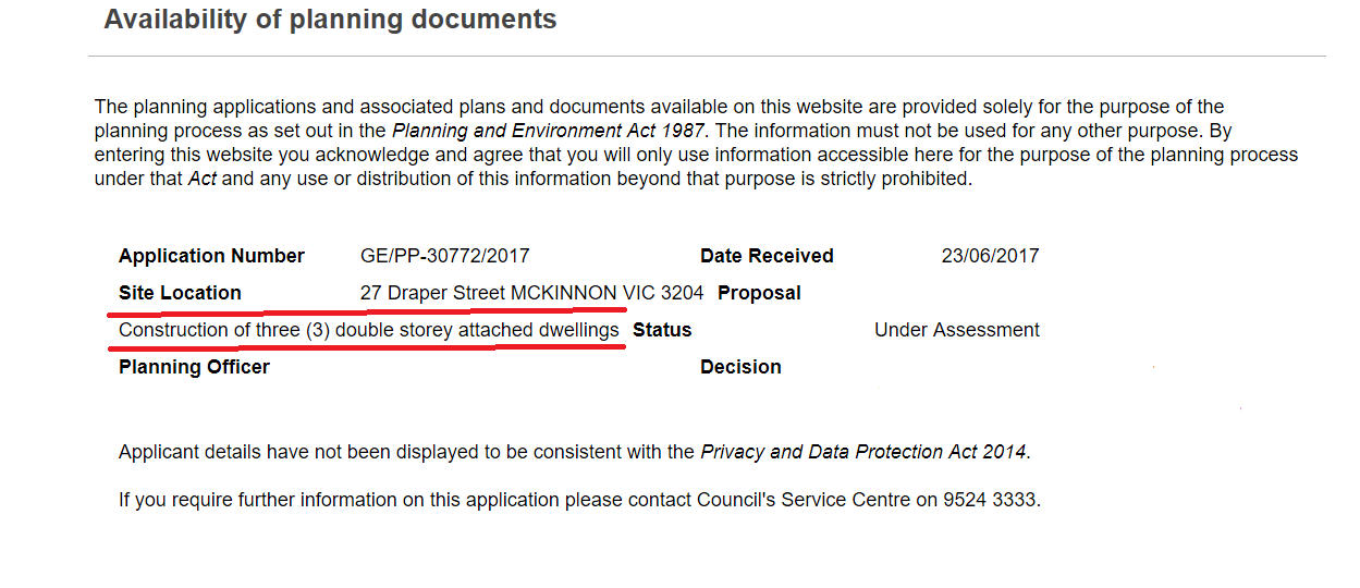
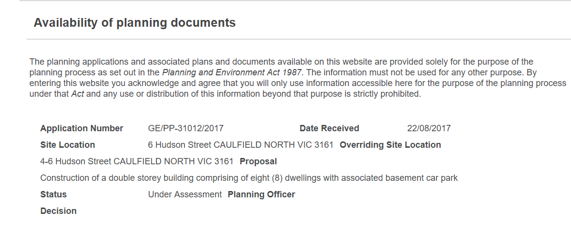
- 4-6 Hudson Street is applying for 8 dwellings on a site of 1308 square metres. According to the above table this should only result in a ‘net gain’ of 3 dwellings. If a permit is granted the NET GAIN IS 4 DWELLINGS.
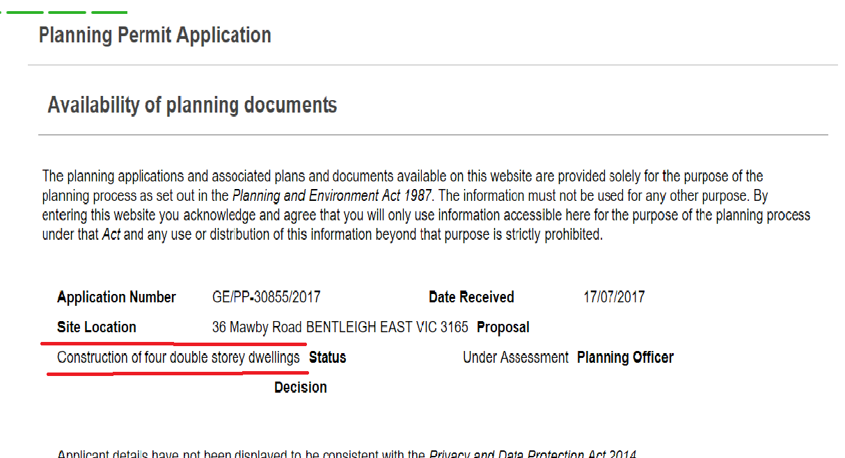
- 36 Mawby Street is applying for 4 dwellings on 740 square metres. The report suggests that this will result in a ‘net gain’ of 1.3 dwellings. The result would be a net gain of 2 dwellings.
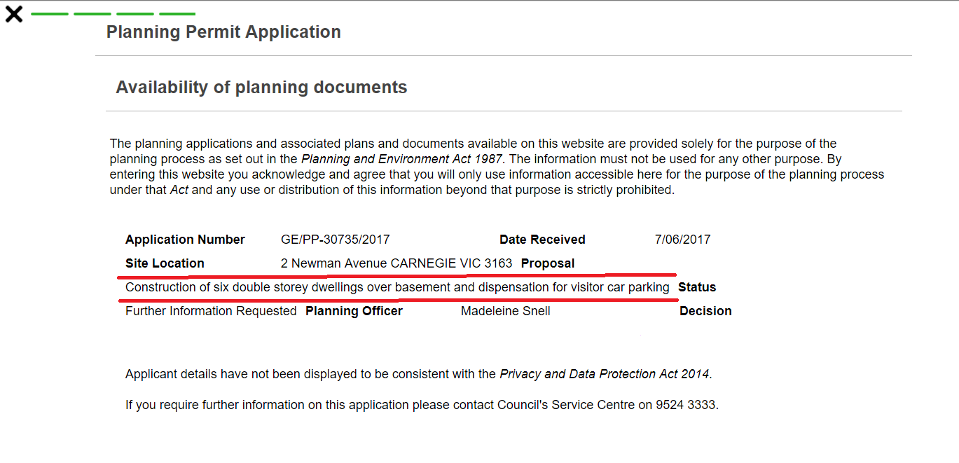
- 2 Newman St is applying for 6 dwellings on 964 square metres. The report suggests a net gain of 1.9 dwellings. If approved, the net gain will be 4 dwellings.
- 5 Rigby Avenue is applying for 5 dwellings on 877 square metres. Again the report would suggest that this is a net gain of 1.9 dwellings. The gain is 3 dwellings.
As a total from these 10 applications, and assuming they will all be granted permits, we have the prospect of 41 dwellings instead of 20 dwellings. That is a doubling in yield from March 2017. And this is only the beginning. What happens in the GRZ zoned areas is yet to unfold.
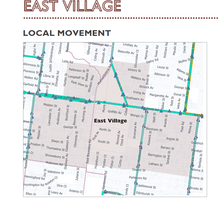
EAST VILLAGE
The East Village Activity Centre has now mushroomed into an enormous area that also includes Virginia Park. Given what’s happened with Bentleigh we are confident that this will now be the borders of the new ‘activity centre’. Virginia Estate is smack in the middle of this ‘activity centre’.

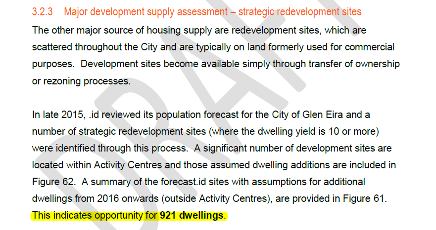
Despite various sections of the Housing Report referring to ‘development sites’, Virginia Estate is not included in any calculation, in any forecast, nor in any comment as to how this 20 hectare site might impact on housing numbers. Absolutely extraordinary when it is clear that this site has the potential to house anything from 3500 to 4500 new apartments. What we do get is this convenient ‘get out of jail’ clause – No assumptions have been made about the conversion of additional industrial or commercial land being rezoned for residential purposes and the dwelling yields that might arise from such a process.
Surely any decent and ‘objective’ analysis of housing capacity in a municipality must include the largest site in all of Glen Eira? And then go on and provide some possible scenarios of what 3500-4500 new dwellings would mean for ‘housing opportunities’ overall. If one 20 hectare site is about to become the greatest residential development in Glen Eira’s history, then surely some slack can be given to other areas? But no! Council’s view is the more the better and the report plays along via its silence on this issue.
Despite what we cited from the report previously (ie ignoring commercial and industrial land) the report also includes the following:

Thus if a major source of housing supply is ‘redevelopment sites’, then what credibility should be given to a report that totally ignores these massive sites? Even more ludicrous is the fact that council is now working on an East Village/Virginia Estate Structure Plan that is, we assume, independent and separate from what its Activity Centre consultants determined as the entire area. (ie above graphic of East Village ‘study area’).
There are a multitude of questions that demand answering and which council has steadfastly refused to address. Instead, residents have been fed, in dribs and drabs, consultant’s reports that raise more questions than they answer and which often fail to stand up to full scrutiny. If you can’t trust the data, then you can’t trust the conclusions and the outcomes.
Finally, we highlight one other paragraph from the Housing Report that typifies the inconsistency and lack of strategic justification for much of council’s planning. The paragraph concerns the ‘values’ assigned to each activity centre. The higher the value, then the more development was likely to occur according to the Household report.
At the other end of the scale, East Village recorded the lowest score, receiving just one point out of five. This centre does not have railway or tram services, and has minimal retail and other services along its commercial spine. It is also split by two major arterial roads that impacts on urban integration. East Bentleigh also received a relatively low score of just two points. It was notable that lack of public transport access was the major reason why these centres scored poorly when measured against the attributes.
If council is reliant on its consultants and won’t do anything without ‘evidence based’ data, then why, given this report:
- Is Bentleigh East being ‘upgraded’?
- Why isn’t Caulfield, nominated as a Major Activity Centre by Plan Melbourne, being given priority ahead of say Caulfield South and Bentleigh East?
The lack of transparency in everything council has done must be highlighted. We have morphed from ‘study areas’ to actual increased borders of activity centres; asking what people ‘love’ about their ‘shopping strips’ achieved nothing except focusing residents’ attention on the shops themselves instead of all the related issues such as building heights, open space, etc. etc. etc. The list goes on an on. Now a year down the track residents are still being kept in the dark as to:
- precise housing numbers required to meet population growth
- strategic justification for increased activity centre borders
- strategic justification for 8-12 storeys
- costs
- timelines
- future of neighbourhood centres
- whether or not Glen Huntly, East Bentleigh, Caulfield, Caulfield South, Ormond will have more of their areas turned over for increased development
- high rise at railways – Bentleigh, McKinnon given council’s cryptic comments of the past
Other councils do not operate in this fashion. Their consultants reports do not ignore commercial and industrial land. Their consultants provide a ‘cost-benefit’ analysis for what is termed ‘community benefit’. The list goes on and on. When compared to other councils and their community consultations Glen Eira continues to exhibit all the old traits of lack of transparency, accountability and a genuine intent to listen to the community.