GE Governance


Apologies for this long, long post. It concerns the agenda for Tuesday night’s council meeting. There are many items that deserve comment – some good, some bad, and some particularly atrocious and misleading!

THE GOOD

After years and years of complaint regarding council’s lack of transparency and accountability, there does appear to be some movement at the station –

  • Item 9.8 recommends a tender be decided for telecasting both ordinary and special council meetings. We certainly welcome this and hope that those councillors who previously opposed such a move will now vote in favour. One proviso however is that no mention is made of when this will be up and running (if voted in).
  • For the first time there is now a running sheet of motions to be put forward at the MAV state conference – including how council will vote on the various motions. Previously these were all decided behind closed doors, so again a welcome new initiative. However, we also note that the rationale behind council’s position on many of these motions has not been included.
  • Another item features the review of the Community Engagement Policy. One important advance is the promise to ‘monitor’ and ‘evaluate’ the outcomes. For some unknown reason however, the actual policy is not included in the online agenda!

THE BAD

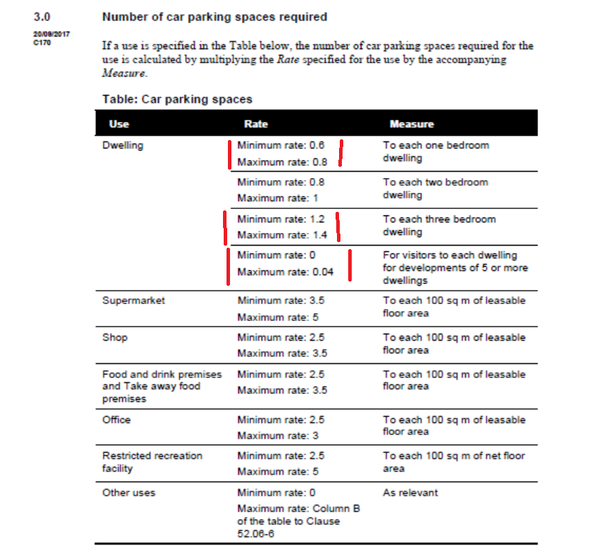
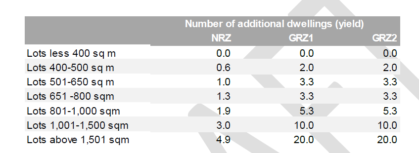
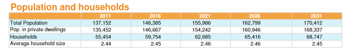
The most important item for this section is council’s application for an extension on the interim height amendments for Bentleigh and Carnegie. The current amendment expires on December 31st 2017. Council is now requesting a one year extension. What this basically means is that residents will not have the structure planning work completed and gazetted for the major activity centres until at least mid 2019! Worth remembering is that there is not even any ‘interim’ protection for Elsternwick! Further, no mention is made of the current neighbourhood centres – these could be waiting well into the 2020’s! Our concern is that with the constant delays more and more development will occur that will undermine the very objectives of the structure planning work itself. For example: it will be very hard to argue for a 5 storey mandatory height limit when countless buildings already exceed this height and which leaves the door open for similar developments over the next 2 to 5 years. What is certain is that if development continues as it has, especially in neighbourhood centres, then any attempt to rein in development will be that much harder if not impossible!

The above leads onto questioning council’s whole approach to their planning process – namely:

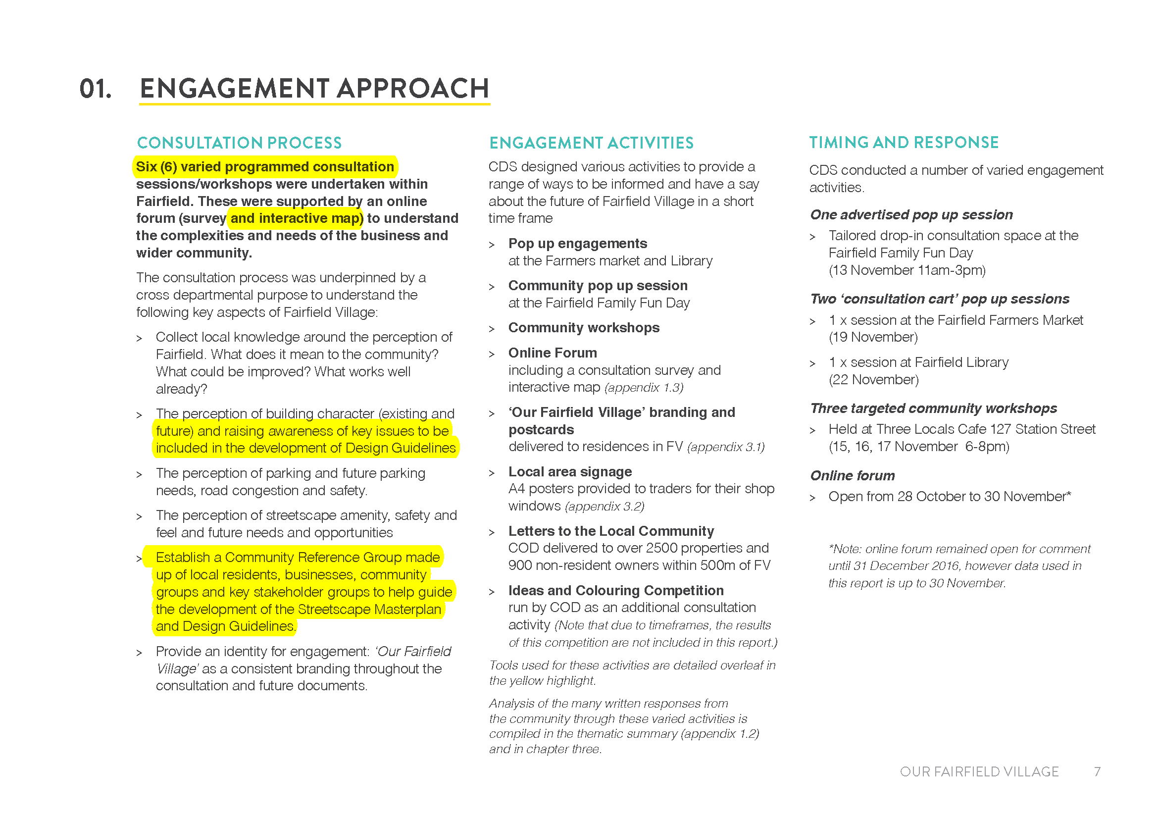
  • Why has it taken til now for those in power to realise that council’s approach to consultation has only now become ‘tangible’ to residents? What does this imply about the intent of the ‘consultation’? We have remarked previously on the lack of detail provided, the lack of strategic justification provided, the lack of genuine reporting of community feedback. From the first stage we have queried the validity of council’s approach – ie asking questions such as ‘what do you love about your shopping strip’ only serves to focus residents’ attention on the commercial strip itself. It does not guarantee that feedback will focus on the primary issues of development, open space, traffic, infrastructure, etc. As an example of what should have been done, and could have been done, readers may find the following screen dumps informative. They come from the Banyule consultation on Fairfield. Please note that the same consultants were used by Glen Eira. The difference in approach is staggering. Why is it that for the Banyule consultation this company included direct questions on height, traffic, etc. and in Glen Eira none of these queries were specifically included in the initial consultation. Surely the only reason to explain this is the brief provided to the consultants! In other words, hired guns again doing council’s bidding!


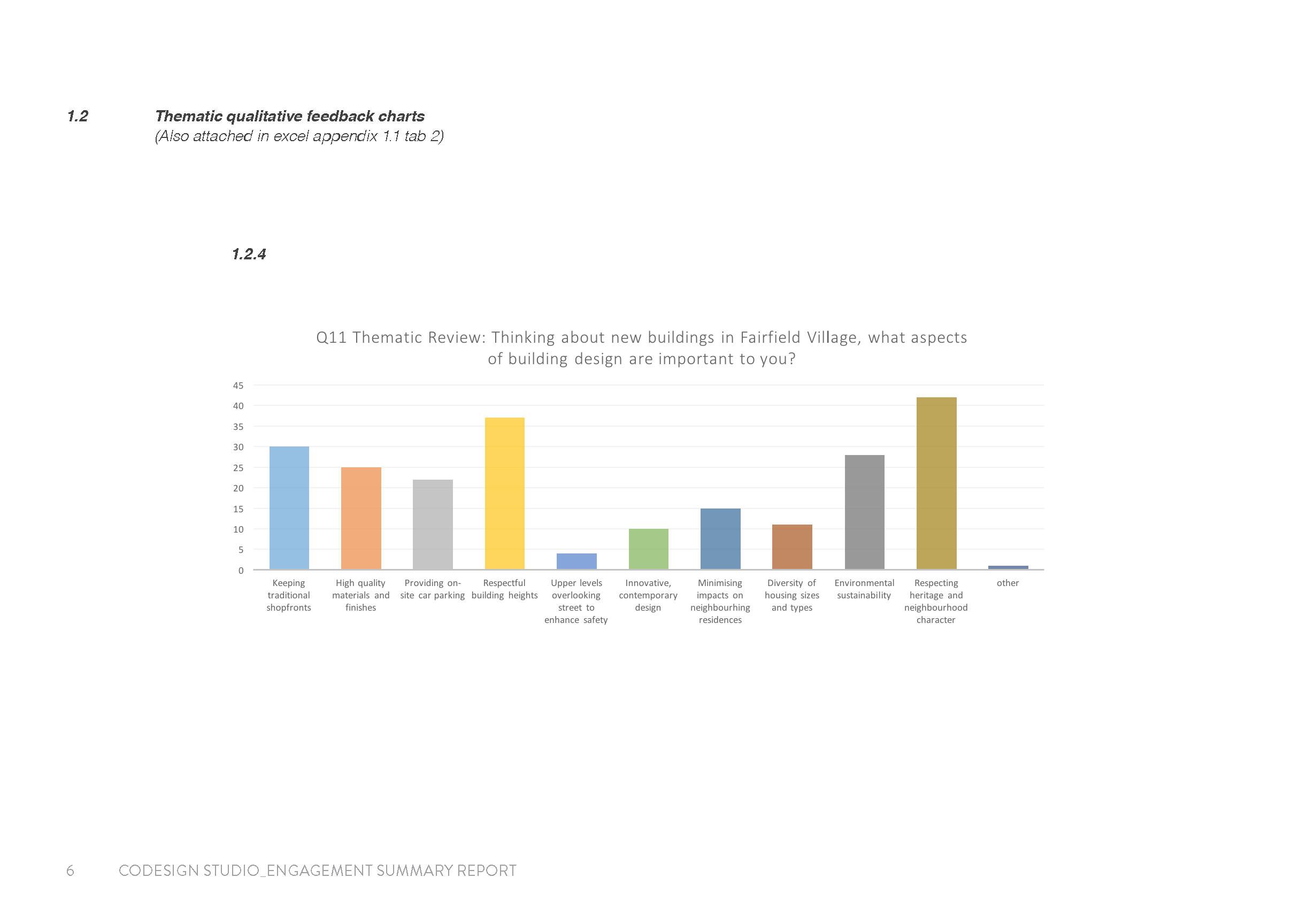
Plus some screen dumps of the initial ‘consultation’ processes employed in Banyule. Compare this with what Glen Eira did!

  • Given the amount of work required why has it taken over a year to advertise for an additional 4 planning staff (ie consecutive ads over 2 weeks). And this is on top of continued planning applications, VCAT appeals, etc. and council repeatedly bemoaning the fact that they have been inundated with applications and that more and more cases end up at VCAT. This trend has been evident since the introduction of the zones but it has taken 4 years to act!
  • Making matters even worse is item 9.2 in the agenda. For a ‘simple’ 2 double storey application in Thomas St, East Brighton, council couldn’t reach a decision in the required 60 days. This, despite the fact that they admit the following – The application was lodged on 28 November 2016. The application was advertised from 27 April until 15 May 2017 and 1 objection was received. The applicant lodged an appeal at VCAT on 6 September 2017 against Council’s failure to make a decision within 60 statutory days. Our sympathies to the developer in this instance since it is unfathomable why such an application should take forever to finalise! Of course, this means more money spent by ratepayers at VCAT! Please note we are not commenting on the merit of the application – merely on the unbelievable time lines.
  • We also observe that in the past year or so the number of refusals for 2 double storeys in the NRZ has gone through the roof. Invariably, our analysis indicates that in over 95% of cases that end up at VCAT, the applicant gets his 2 dwellings!
  • The only ‘positive’ out of all this is that council has at least had the good grace to publicly admit how inept it has been – there has been community feedback regarding the overall process including:
    • Requests for city-wide dwelling forecasts that inform the structure planning
    • Improved communication to all residents and landowners within the study area for the next stage of engagement
    • An appropriate level of detail for best consideration of positive and negative impacts of the proposals

Ensure the next round of consultation period allows affected parties enough time to read through the released information in detail, attend information sessions and provide a response to Council.

Surely this should have been a given right from the start? 

THE UGLY

The ‘ugly’ aspect of this agenda is council’s continued inability to reveal the truth in an honest and upfront manner. Instead we are presented with the usual spin and misleading statements designed to basically cover up what actually happened. Here is the offending extract –

We have commented on this issue previously, (see: https://gleneira.wordpress.com/2014/08/19/inept-or-indifferent/) but will repeat the evidence which shows beyond any shadow of a doubt that:

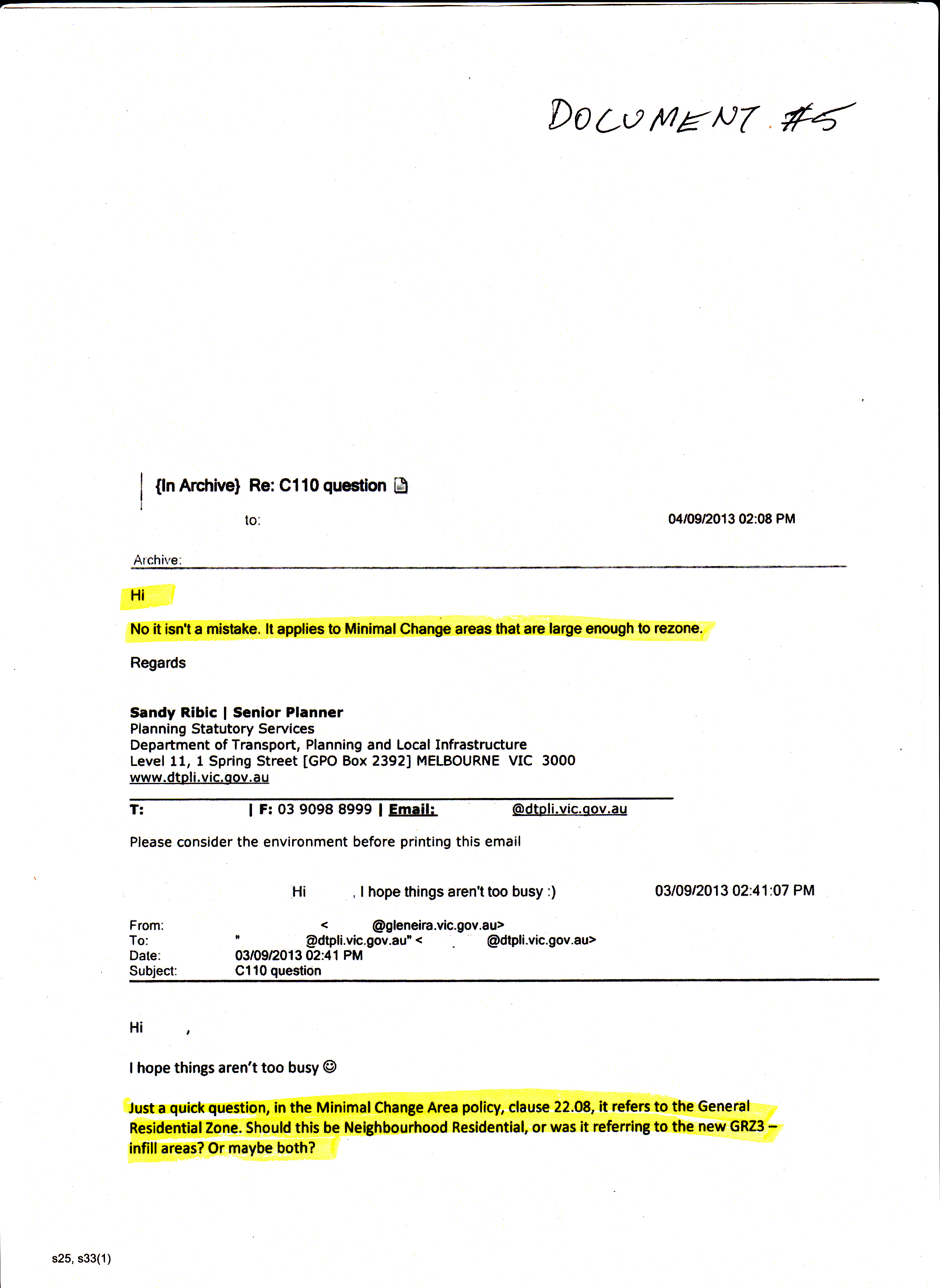
  • Senior officers knew of this ‘error’ back in July 2013
  • That from the department’s point of view this was not an ‘error’ but a required trade off for the introduction of the residential zones
  • Council also knew that at least one case went to VCAT where the developer tried to use this clause to his advantage (unsuccessfully).
  • To now turn around and claim that this ‘error’ has only been ‘recently’ discovered is a blatant lie! Even if Akehurst and Camera (the ‘architects’ of the residential zones) are now gone, Torres is still at council as are many other senior planners. Where is corporate memory? Why can’t council simply admit the truth?

The decision for 277-279 Centre Road, Bentleigh has finally been handed down by VCAT. The original application for a 9 storey development was amended by the applicant to 7 storeys. VCAT granted a permit for the 7 storeys.

What is crucial in this decision is the fact that the site sits within the recently gazetted amendment for a 5 storey preferred maximum height – ie under the Design and Development Overlay (DDO8). The amendment was hailed as the ‘solution’ to overdevelopment by council and the Minister – despite residents wanting mandatory height limits for the entire area.

There are several extracts from the decision worth highlighting. They reveal once again council’s inept planning – ie almost nonsensical would be a good description of what constitutes the amendment and its decision guidelines (in bold below). It also points to the current ludicrous plans to allow 8 storeys! Finally, we also find mention of the necessity for a parking precinct plan – something that has been on council’s mind for the last 15 years! They have just never got around to doing anything of course!

The take home message is clear:

  • preferred maximum height limits are useless
  • council’s planning department is performing well and truly below standard
  • these decisions need to be addressed in any structure planning and to ensure that all the countless loopholes are removed
  • strategic justification was not in existence for the Carnegie/Bentleigh amendments. We maintain that they are non existent for the current activity centre structure planning as well!

The source for the following extracts is: – http://www.austlii.edu.au/cgi-bin/viewdoc/au/cases/vic/VCAT//2017/1656.html

It is Council’s submission that the introduction of the DDO8 was to temper expectations and outcomes during the period that the controls apply and clearly seek to limit the nature of the development proposed. What Council does not state however is that the overlay does not impose a mandatory height in ‘Area 3’ such as other ‘Areas’ have. This suggests to us that the controls allow for consideration of heights that do exceed the Preferred Maximum. We therefore look for guidance from the DDO8 in assessing the proposed development.

  • If we refer to the decision guidelines of the DDO8 as the relevant ‘test’ to assess if seven storeys, instead of five storeys is appropriate, we make the following findings.
  • Council put to us that this site fails to perform a transitional function (within the activity centre) resulting in a jarring impact at the edge of the Urban Village. We do not agree with this submission. This site is not at the edge of the Urban Village, it may be at the edge of DDO8-3 and DDO8-1. Therefore, we do not agree that it is the role of the site to perform a transitional function. There is currently a five-storey building under construction on the corner of Rose Street which is at the edge of DDO8-1. This is the site that performs a transitional role to the centre and Residential Zones beyond it. The review site is located within the retail hub of the Bentleigh Urban Village and whilst it is not located on the railway station, it is also not located at the edge on Rose Street. We conclude that we do not agree with Council that this site is to serve a transitional function.

There is nothing in the Planning Scheme to require a uniform height in this location. The decision guidelines of DDO8 question whether the proposal is compatible with and respect the character of neighbouring buildings within the same streetscape. We find this a curious guideline. How can a building ‘respect the character of an adjoining single storey neighbouring building when the preferred maximum height is five storeys? Is it to be interpreted that the DDO8 control determines that (in this case) a five storey building adjoining a single storey built form is respectful? It would be nonsensical to assume that a proposed built form even at five storeys would be considered as ‘not respecting a neighbouring building’. This is an example of where strategic work would provide for background as to what and how a guideline such as this is to be interpreted, if indeed, it remained in the overlay. We consider that it has to be the way the proposed built form responds to each interface that is most important, just as the podium base of the building is respectful of the form of built form within the street. This guideline is balanced against others including policies calling for more intense development in activity centres and urban villages.

We conclude that it is reasonable to reduce the car parking requirement and waive the requirement for the 4 residential visitor and 17 commercial spaces. The planning scheme also supports sustainable transport alternatives and the efficient use of car parking. In response to Council’s concerns regarding the future development of the centre and the potential increased car parking pressure, parking in the centre as a whole is a broad issue and one that may warrant strategic planning in the form of a car parking precinct plan.

The ABS has today released its figures for building approvals for the months of July and August, 2017. They have also updated their data for the 2016/17 financial year. Glen Eira’s numbers for the past financial year were upgraded to 2021 building permits granted.

Please consider the table below. Glen Eira is now not only the biggest development municipality in the south east, but is winning hands down for the Northern suburbs alone. If the current rate continues, then Glen Eira will well and truly surpass another 2000 net new dwellings per year!

We have uploaded the full Excel spread sheet HERE

Readers may also find the suburb analysis of interest as well (uploaded HERE). Please note that Bentleigh-McKinnon is now far ahead of Carnegie. Quite incredible considering that McKinnon is merely a poor old neighbourhood centre in council’s heirarchy and Bentleigh is supposed to have only ‘minimal’ growth according to the structure planning documentation. The bottom line remains, we believe, that land zoned GRZ provides easier and cheaper pickings for developers – and McKinnon, Ormond have plenty of land zoned GRZ. Our prediction, unless zoning changes dramatically, is that these figures only represent the tip of the ice-berg and more and more development will be focused in our neighbourhood centres – especially since council has not provided any timelines for addressing this crucial issue or providing any information as to its intentions for these suburbs!

Source: http://www.dtf.vic.gov.au/Infrastructure-Delivery/Victorian-Government-land-sales/Recent-sales-history

The above image details recent government sales.  In this instance, we highlight crown land that has been zoned under ‘education’. The site at 100 Queens Avenue is a single storey building (primarily computer labs) plus an adjacent car park that has been there for eons.  Questions abound:

  • Why was the land sold?
  • Who bought the land? and
  • If it is Monash, then why on earth spend $8m for a quarter of a hectare?
  • Or is the buyer a private developer?
  • And if a private developer, does this mean high, high rise residential?
  • How much does council know?
  • Why the total lack of transparency, discussion?
  • What will this now be rezoned to?
  • What role has the vpa played in all of this?
  • Exactly how much do our elected representatives know?
  • What are the implications for the adjoining open space? Will this be flogged off too?
  • How many storeys are required to recoup a reasonable profit on $8m?
  • Finally, as a worst case scenario, is the MRC involved in any way?

Until facts are forthcoming then residents have every right to be concerned about the lack of transparency at all levels of government!

Why is it that practically every stat published by council is highly questionable? The latest example concerns their statement that for the financial years of 2015/16 and 2016/17 planning permit approvals were granted for the following numbers of net new dwellings –

  • 2604 net (additional) dwellings approved in in 2015/2016.
  • 2728 net (additional) dwellings approved in in 2016/2017.

Councils are required to forward their data to the State Government’s DWELP. The numbers are then put onto the Planning Permit Activity website. This section of the department basically serves as a repository for data that has been supplied by councils. Thus we are left with the question of the accuracy of the supplied data. Which figures are residents to believe? Council can’t have it both ways. Either the figures quoted above are a fiction, or those supplied to the government are a fiction.

Here is what the Planning Permit Activity reports as the results for 2015/15 and 2016/17 based on their quarterly reports (See: https://www.planning.vic.gov.au/publications/planning-permit-activity-in-victoria/planning-permit-activity-quarterly-report ) Readers can then backtrack to the various three quarterly reports and add up the figures for themselves.

2015/16 – 2133

2016/17 – 1806

The discrepancies are not minor – equalling roughly 500 net new dwelling approvals in 2015/16 and 900 in 2016/17. How can this happen and if deliberate, then what is the purpose?

Perhaps the answer might lie in these figures (which are correct) provided by council –

Within the past two years we have seen the following Building Permit net dwelling approvals:
·         1681 net (additional) dwellings approved in in 2015/2016.
·         1993 net (additional) dwellings approved in in 2016/2017.
According to council, the correlation per year between building permits and planning permits approaches the 1000 discrepancy mark. But if we look at the Permit Activity numbers from the government website, the discrepancy halves and makes the following council statement that much harder to swallow –
However, planning permits and even building permits are not always acted upon, and so they do not paint an accurate picture of what will be constructed. In fact, ID consulting advice show that historically in Glen Eira, only just over half of dwellings approved through a building permit will go on to be constructed.
Does this paragraph mean it will never be built, or just for the respective year? What about ten years down the track? Are we still maintaining that only 50% is built? We admit that there is land banking, or some developers may go bust, but we certainly dispute the figure of 50%. Obtaining land, planning permits, building permits, constitutes a huge investment. Then there are undoubtedly finance costs, interest, land tax, etc. etc. Money is in building and selling and since property prices are already at an all time high, and forecast to drop, why would any developer sit back with his planning and building permits and not act on these? And finally, is such a statement by council intended to cast doubt on the fact that Glen Eira is without a shadow of a doubt the development capitol of the South East?

Despite the ‘tactfulness’ of the missive presented below, it is very clear that Staikos (and Wynne) are far from happy with our wonderful council. The reasons are obvious:

  • Wynne grants interim height guidelines of 5 and 4 storeys for Bentleigh and 7 and 6 storeys for Carnegie and council literally thumbs its nose at this with its proposed 8 and 12 storeys respectfully.
  • Community outcry is growing and state elections are not that far off
  • Repeated questions to council remain unanswered, and concept plans lack all strategic justification – especially the ‘upgrading’ of East Bentleigh.

The Ormond Tower Amendment (c170) was finally published today. It is frankly an abomination! Here is a rundown of the lowlights –

  • The area is now zoned as a Comprehensive Development Zone with its own schedule
  • Parking allocations are minimalist and well below what is required
  • Height limits are NOT mandatory
  • The Minister retains control over everything – no third party objection rights
  • The ‘development plan’ is nothing more than politspeak and in our view hardly qualifies as a decent planning document that residents can have faith in. (Uploaded HERE)
  • New clauses introduced into the planning scheme reinforce all of the above nonsense – ie Clause 21.04 now includes – Recognise the opportunity for landmark built form, on strategic redevelopment sites made available through the removal of a level crossing, to establish a new character whilst maintaining neighbourhood amenity
  • It should also be noted that the Minister has not released the report upon which his decision is supposedly based!

The following screen dumps summarise the amendment –

PARKING

BUILT FORM, SETBACKS & HEIGHT

What this augurs for Bentleigh & McKinnon is anyone’s guess!

Council is making much of the fact that in its current draft structure plans many areas now zoned for 4 storeys will be reduced to either 3 storeys or 2 storeys. They claim that in Bentleigh alone this ‘revision’ equals ten hectares. This figure is completely misleading since it does not reveal what has already happened.

In Bentleigh, part of the new vision is to rezone Mitchell and Robert Streets from 4 storeys to 3 storeys (light green) but at the same time to ‘upgrade’ another 10 properties from 2 to 3 storeys (light blue).

The light green changes are then included, we presume, in the calculation of council’s magnanimous reduction of 10 hectares worth of properties. If only it were so! The image below shows the current situation in Mitchell and Robert Streets. The yellow infill represents 4 storey developments already being built or with permits grants. The total land area these developments occupy is 0.89 hectares. We have not bothered to calculate other areas of Bentleigh. We simply highlight the fact that once again council’s figures need to be taken with a huge grain of salt!

Council has in all probability spent a fortune on consultants. As we’ve stated previously, consultants are basically hired guns. Much depends on their brief and the directions issued to them by council staff. This is made crystal clear in the Introduction to the consultant’s Housing Study. We’re told that the objective is –

To assist in preparing the (activity centre structure planning) strategy, Council has commissioned .id (Informed Decisions) to undertake an analysis of housing consumption patterns and opportunities. It also includes an assessment of centres identified by Council as appropriate for intensification and their potential dwelling capacity

Thus from step one the game is virtually rigged! It is council staff who have decided which areas are ‘appropriate for intensification’, where the borders will now be, and which areas will be upgraded to allow for more intense development – but without providing residents with the necessary logic behind any such decisions nor any data that might justify such decisions.

Not for the first time in this entire structure planning process, have we been provided with consultants’ reports which in many areas are certainly open to question. The latest example(s) come from the Housing Report.

‘NET GAIN’ OF DWELLINGS IN NRZ

We are told that the report is dated May 2017. That is 2 months after Wynne introduced VC110 which removed the mandatory 2 dwellings per lot in the Neighbourhood Residential Zone. It is therefore fascinating to observe that the Housing Report does not once make specific mention of this fact – although there is reference to the ‘garden requirements’ and height limits.

Why not state the removal of the mandatory 2 dwellings per lot up front? Why not address its potential impact across all of Glen Eira and not just those areas immediately outside the designated activity centres? We proffer the answer that this would cast some serious doubt on the figures provided by the report – even though they are claimed to be ‘conservative’. If there is no limit on the number of dwellings now permissible in NRZ, then that means that infill will in all likelihood  be far greater than suggested by the report. If it is therefore greater, then the argument could follow that activity centres do not need to be so gung ho in allowing more development. That in fact much of the current zoning can be reduced and that there certainly is no need to expand the borders of activity centres and rope in more dwellings for greater development.

The report goes on to claim that in the NRZ areas there will only be the following number of ‘net gain’ new dwellings –

We now have 10 applications in for multi unit development in NRZ. These applications reveal how suspect the Household predictions are. For example:

  1. 4-6 Hudson Street is applying for 8 dwellings on a site of 1308 square metres. According to the above table this should only result in a ‘net gain’ of 3 dwellings. If a permit is granted the NET GAIN IS 4 DWELLINGS.
  2. 36 Mawby Street is applying for 4 dwellings on 740 square metres. The report suggests that this will result in a ‘net gain’ of 1.3 dwellings. The result would be a net gain of 2 dwellings.
  3. 2 Newman St is applying for 6 dwellings on 964 square metres. The report suggests a net gain of 1.9 dwellings. If approved, the net gain will be 4 dwellings.
  4. 5 Rigby Avenue is applying for 5 dwellings on 877 square metres. Again the report would suggest that this is a net gain of 1.9 dwellings. The gain is 3 dwellings.

As a total from these 10 applications, and assuming they will all be granted permits, we have the prospect of 41 dwellings instead of 20 dwellings. That is a doubling in yield from March 2017. And this is only the beginning. What happens in the GRZ zoned areas is yet to unfold.

EAST VILLAGE

The East Village Activity Centre has now mushroomed into an enormous area that also includes Virginia Park. Given what’s happened with Bentleigh we are confident that this will now be the borders of the new ‘activity centre’. Virginia Estate is smack in the middle of this ‘activity centre’.

Despite various sections of the Housing Report referring to ‘development sites’, Virginia Estate is not included in any calculation, in any forecast, nor in any comment as to how this 20 hectare site might impact on housing numbers. Absolutely extraordinary when it is clear that this site has the potential to house anything from 3500 to 4500 new apartments. What we do get is this convenient ‘get out of jail’ clause  – No assumptions have been made about the conversion of additional industrial or commercial land being rezoned for residential purposes and the dwelling yields that might arise from such a process.

Surely any decent and ‘objective’ analysis of housing capacity in a municipality must include the largest site in all of Glen Eira? And then go on and provide some possible scenarios of what 3500-4500 new dwellings would mean for ‘housing opportunities’ overall. If one 20 hectare site is about to become the greatest residential development in Glen Eira’s history, then surely some slack can be given to other areas? But no! Council’s view is the more the better and the report plays along via its silence on this issue.

Despite what we cited from the report previously (ie ignoring commercial and industrial land) the report also includes the following:


Thus if a major source of housing supply is ‘redevelopment sites’, then what credibility should be given to a report that totally ignores these massive sites? Even more ludicrous is the fact that council is now working on an East Village/Virginia Estate Structure Plan that is, we assume, independent and separate from what its Activity Centre consultants determined as the entire area. (ie above graphic of East Village ‘study area’).

There are a multitude of questions that demand answering and which council has steadfastly refused to address. Instead, residents have been fed, in dribs and drabs, consultant’s reports that raise more questions than they answer and which often fail to stand up to full scrutiny. If you can’t trust the data, then you can’t trust the conclusions and the outcomes.

Finally, we highlight one other paragraph from the Housing Report that typifies the inconsistency and lack of strategic justification for much of council’s planning. The paragraph concerns the ‘values’ assigned to each activity centre. The higher the value, then the more development was likely to occur according to the Household report.

At the other end of the scale, East Village recorded the lowest score, receiving just one point out of five. This centre does not have railway or tram services, and has minimal retail and other services along its commercial spine. It is also split by two major arterial roads that impacts on urban integration. East Bentleigh also received a relatively low score of just two points. It was notable that lack of public transport access was the major reason why these centres scored poorly when measured against the attributes.

If council is reliant on its consultants and won’t do anything without ‘evidence based’ data, then why, given this report:

  • Is Bentleigh East being ‘upgraded’?
  • Why isn’t Caulfield, nominated as a Major Activity Centre by Plan Melbourne,  being given priority ahead of say Caulfield South and Bentleigh East?

The lack of transparency in everything council has done must be highlighted. We have morphed from ‘study areas’ to actual increased borders of activity centres; asking what people ‘love’ about their ‘shopping strips’ achieved nothing except focusing residents’ attention on the shops themselves instead of all the related issues such as building heights, open space, etc. etc. etc. The list goes on an on. Now a year down the track residents are still being kept in the dark as to:

  • precise housing numbers required to meet population growth
  • strategic justification for increased activity centre borders
  • strategic justification for 8-12 storeys
  • costs
  • timelines
  • future of neighbourhood centres
  • whether or not Glen Huntly, East Bentleigh, Caulfield, Caulfield South, Ormond will have more of their areas turned over for increased development
  • high rise at railways – Bentleigh, McKinnon given council’s cryptic comments of the past

Other councils do not operate in this fashion. Their consultants reports do not ignore commercial and industrial land. Their consultants provide a ‘cost-benefit’ analysis for what is termed ‘community benefit’. The list goes on and on. When compared to other councils and their community consultations Glen Eira continues to exhibit all the old traits of lack of transparency, accountability and a genuine intent to listen to the community.

Council’s response to a public question asked at the last council meeting continues the tradition of – (a) not answering what was specifically asked; (b) revealing only half of the story, and (c) resorting to a plethora of meaningless motherhood statements.

We ask readers to especially focus on the highlighted sections in the following image. The question asked two specific things – why all of council’s documentation largely failed to take into account the development potential of Caulfield Village and Virginia Estate AND why council is proposing the expansion of our activity centres and hence more development when council is already well and truly surpassing its housing targets.

THE ‘ANSWER’

  • Council refers to the current planning scheme. Well the current planning scheme which is so out of date it is irrelevant states clearly that: there will be a need to plan for the additional 6,000 dwellings which are predicted for Glen Eira by 2021 as well as encouraging a more diverse housing stock (Department of Infrastructure, 1999, Victoria in Future).
    Not a word about 9000 or 2031!
  • Council then conflates the consultant’s Housing Study with Victoria in Future 2016. Far more damning however is the deliberate omission of some vital information. Here are the Victoria in Future projections where the 9000 additional dwellings is to be found in the time span from 2016 to 2031. Even these figures result in an average new dwellings per year of 642. Glen Eira’s average is practically triple this.
  • Nowhere in the housing study is the figure of 9000 mentioned. In fact, we’re told that in 2013 the available land promised 87 years of growth, but as of now this has been reduced to only 37 years. Are we therefore to conclude that development in Glen Eira has been so dramatic and drastic that in the space of 4 short years developers have gobbled up 50 years worth of previously available land? If so, then what does this say about our rate of development and the need for more development?
  • We might also ask what is the motive behind the use of the word ‘just’? Does this mean that according to council the projected housing growth is barely achieving what it must and this is the ‘excuse’ for facilitating more development? Where is the data to support such an outrageous claim?
  • Further the entire statement ignores what has been happening prior to 2016 and the amount of new dwellings that have already occurred in Glen Eira. Here are the figures for building approvals from 2011 to 2016 –
  • 2011/12 – 912
  • 2012/13 – 957
  • 2013/14 – 1,231
  • 2014/15 – 1,786
  • 2015/16 – 1,680
  • 2016/17 – 1991

That makes a grand total of 8557 in the space of 6 years. Victoria in Future 2016 projections are 13,000 from 2011 to 2031 – again reinforcing the fact that Glen Eira is capable of meeting its housing needs with an average of 650 dwellings per year. Even if this years Victoria in Future increases the number of projected dwellings needed, we maintain that Glen Eira remains well and truly ahead of the pack in the development game.

  • As for the 10 hectares of land now claimed to be ‘saved’ from 4 storey development it would be far more credible if council actually calculated how much land in the current RGZ areas was already chocka-block full of four storeys. Perhaps that would leave only 6 or 5 or 4 hectares that are now ‘saved’?
  • The most unbelievable statement is – the issue is not just about numbers. Surely it is the numbers that determine the required extent of new development? Surely it is the numbers that determine whether activity centre borders need to be doubled in size? Surely it is numbers that determine whether or not the municipality requires 12 storeys of mainly residential development in order to play its fair share in accommodating population growth? And the most important question – if structure planning is meant to apportion appropriate land use outcomes, then numbers are integral to decisions on where, how much, how high, and can the municipality cope with these numbers?
  • Please also note the failure to respond to the issue of Caulfield Village and Virginia Estate. With another potential 5000 dwellings to go up, then ‘first principles’ means nothing. Again, its back to numbers.

The really sad aspect of such a response is that councillors allowed this to go out in their name without a murmur. Do they really understand what is going on and have they heard the growing public resentment?

« Previous PageNext Page »