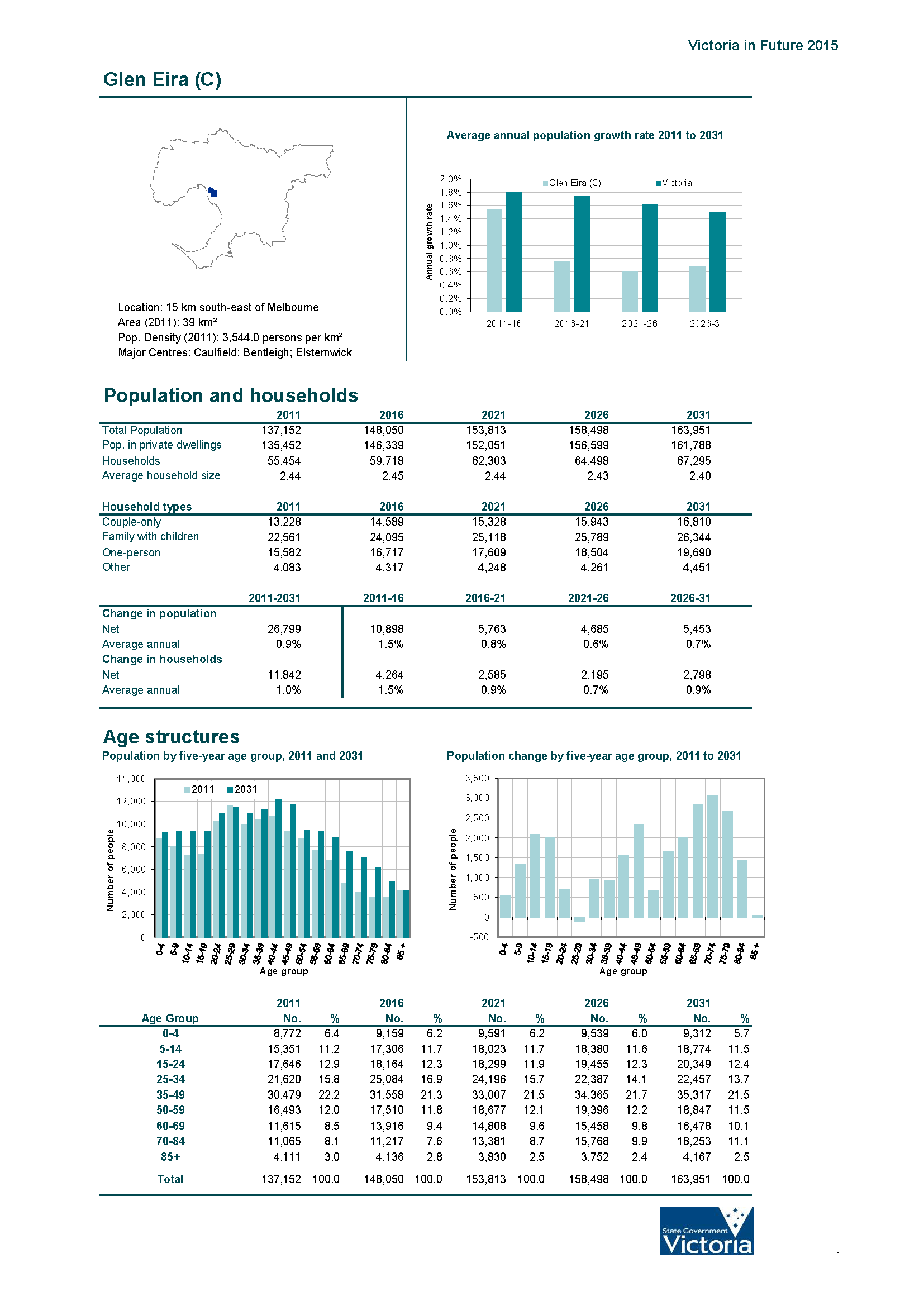
GE Open Space


Why on earth does council even bother to put in submissions to state government reviews when they are invariably of such poor quality? Most are a few pages of self congratulation with a total lack of analysis, detail, and real contribution to the debate. And lest we forget, without endorsement via a council resolution and made public only ‘after the fact’. Frankly, council ought to be highly embarrassed in comparison to what other councils are capable of producing.

The latest effort concerns the State Government’s Plan Melbourne Refresh – a very, very important document that will have a major impact on strategic planning for Melbourne for the next 30 years. There is much in this document that should concern residents:

  • The ‘suggestion’ that middle ring suburbs should contain a 70/30 split of future housing growth
  • Notions of a 20 minute neighbourhood centre
  • Environmental sustainability
  • Changes to planning legislation, and much, much more.

So what is Glen Eira’s response to all these vital issues? Readers should note what our council, unlike countless others, fails to even mention –development contribution levies, tree protection on private and public land. We’ve uploaded the full submission HERE. Below are a few extracts and then a comparison with the views of other councils.

This is a very, very long post, but we urge readers to carefully consider the views presented below.

ON HOUSING AND THE 70/30 SPLIT

The Glen Eira Council view – It is proposed to accommodate the majority of new housing in Melbourne’s established areas, rather than in the growth areas. Glen Eira adequately accommodates population growth through its longstanding housing policies and suite of residential zones. These serve to co-locate higher densities of housing with public transport. A balance has been achieved in maintaining low scale residential areas and channelling housing into locations that can best support change. We have obtained government approval for maximum heights over all residentially zoned land where there were no limits before. Any move through Plan Melbourne 2016 to dilute the protection that Glen Eira has over its residentially zoned land will not be supported.

COMMENT

There is much in the above paragraph that needs to be challenged. For example:

  • How many residents would concur with council’s interpretation of ‘adequately accommodates population growth’ when all the complaints are about traffic mayhem, lack of public open space, lack of well designed buildings, and lack of infrastructure support.
  • What exactly does ‘higher density’ mean when neighbourhood centres such as McKinnon, Ormond, Murrumbeena, and East Bentleigh have the highest proportion of GRZ in their suburbs. Further, if public transport is the ‘key’ to locating ‘higher density’ then East Bentleigh certainly does not fit into this category.
  • What exactly does ‘locations that can best support change’ mean when council has not lifted a finger to introduce any parking precinct plans, urban design frameworks, etc. And how can certain ‘locations’ ‘support change’ when there is absolutely no preferred character statements in the planning scheme for any of the housing diversity areas?
  • Another major furphy is the claim that ‘maximum heights’ are the be all and end all of good strategic planning. And of course there is also the blatant unfounded mantra that ‘all residentially zoned’ land in Glen Eira is now better off. No mention of course of Mixed Use Zones which give a lie to the claim that all residentially zoned land now has height limits.

Thankfully other councils have taken the trouble to analyse and provide some data to support their assertions. They also oppose the introduction of the 70/30 split but at least their arguments have far greater validity, or raise concerns that are never mentioned by Glen Eira – ie neighbourhood character, heritage, employment, etc. Some examples:

BOROONDARA – Council is particularly concerned with the point around ‘low suburban density’ and “to encourage high urban densities and foster more diversity and choice in the housing sector, in closer proximity to public transport and jobs.” Many areas in Boroondara which adjoin public transport corridors consist of high quality residential streets which should be protected from intensive development, particularly apartment buildings. This includes some areas in the vicinity of train stations.

, accommodating the majority of new dwellings in established areas within walking distance of the public transport network can lead to a loss of trees and canopy cover in those areas. Therefore, any regulatory framework needs to take account of the local context and competing objectives and allow a level of discretion in managing these requirements. Further, Council questions the notion of protecting environmental and liveability assets on the urban fringe at the expense of another area’s environmental assets. This includes protecting valued tree canopy cover that reduces urban heat island effect and other valued aspects of Boroondara’s liveability.

The proposed housing target ignores the expectations which Boroondara has around the quality of new development. Importantly though, it makes broad based assumptions around the capacity of existing infrastructure in established areas such as Boroondara to support such intensification. In many instances, local development and social infrastructure already operates at or above capacity. Further, increasing development within these areas will only exacerbate the situation. Established area councils therefore require better infrastructure funding mechanisms to meet  increasing demand and renewal of infrastructure assets.

Council also refutes the claim being made in the Discussion Paper that Melbourne’s middle ring suburbs are accommodating a steadily increasing share of Melbourne’s housing growth – from 25% of building approvals in 2002 to 40% in 2014. This is on the basis of Footnote 6 in the Discussion Paper which states “This is an indicative measure of change in middle suburbs as building approvals include knock down and rebuild developments and therefore not necessarily net additional dwellings.

While knock down rebuilds distort the data, overall, new supply has increased in middle suburbs.” In other words, the Discussion Paper cannot readily point to any data which suggests that new dwelling supply in the middle suburbs has increased to a level which can justify a 70/30 target or sub-regional or municipal wide housing targets more generally. Further, the Discussion Paper notes that Melbourne 2030 aspired to a (roughly) 70/30 housing target, but (at best) Melbourne is being planned on the basis of 61% of new dwellings being located in established areas to 2051 under Victoria in Future 2015……Council does not believe the MAC or the Minister for Planning has strategically justified the imposition of a 70/30 housing target.


MONASH

The issues with existing infrastructure and service levels within the established suburbs of Melbourne is significant and is the major impediment to achieving the 70/30 split and ensuring the Melbourne continues to be a liveable and functional city. If the strategy is to encourage increased density within established suburbs (including parts of Monash), the need to upgrade and provide additional physical and community infrastructure needs to be given a much higher priority and be more clearly acknowledged and planned for in Plan Melbourne.

The Refresh paper identifies ‘low suburban density’ as a problem that needs to be addressed. However, it does not explain why this is a problem. In stating that this ‘problem’ will be overcome, it does not explain whether it still proposes to enable the retention of existing elements of suburban development that many within the community value – such as key elements of the existing neighbourhood character – and how the aspiration to increase the density rather than continue to expand the urban growth boundary will work with the ‘green our city’ elements of the Plan Melbourne strategy.

The Refresh Paper criticises the current aspiration in Plan Melbourne for 50% of metropolitan Melbourne being within the Neighbourhood Residential Zone because ‘applying a zone according to a percentage is an unconventional approach’., however it appears to be taking a similar approach to setting a 70/30 split for new development. Further justification should be provided to support this proposed split, which, if achieved, will lead to a significant change throughout suburban Melbourne. It is not appropriate, for instance to completely remove from any decisions around housing scale, consideration of the character of the area (built or natural / landscape character.

WHITEHORSE

Transport infrastructure has the potential to shape the built form and land use activities of our city. Many investment decisions are made based on the proximity to transport infrastructure regardless of whether it is included in a metropolitan or local planning strategy. However, simply being adjacent to a bus route should not automatically mean that development intensity can be increased. For example, the bus service may be infrequent, or there may be a sensitive environmental or neighbourhood character area nearby that warrants protection. One option is to rank bus or transport routes by frequency and quality before allowing more intensive development across the board. Council notes that it considered this sort of information when it introduced the new residential zones suite into its planning scheme, with this information balanced against environmental and neighbourhood character considerations.

Council would also like to emphasise the importance of integrating planning and building systems and a recommendation along these lines could be included in Plan Melbourne 2016 here. For example, single dwellings on a lot over 300 square metres in most instances do not require planning permission, which often results in a dwelling which is out of character with the surrounding neighbourhood. By being in the building system, Council cannot control the built form outcome on these sites. More consideration to neighbourhood character in the building system, or alternatively, consideration of single dwellings in the planning system, is needed.

MORELAND

Council does not consider increased density should occur at the expense of adversely affecting valued urban character by excessive building height, allowing sub-standard accommodation (as is occurring with some apartment developments) and on the assumption that there is adequate infrastructure in established areas to accommodate increased growth in established areas.

COMMENT

What stands out clearly from the above quotes is that Glen Eira continues with its myth about the new zones being in the ‘right locations’. Every other council comments on the fact that being close to a transport node is not necessarily the best or sole criterion for increased density – especially not if it means the destruction of heritage, neighbourhood character, and environment. But in Glen Eira we have heritage overlays smack in the middle of Residential Growth Zones because they are allegedly ‘close’ to railway stations; we have street after street of beautiful Californian bungalows and Edwardian cottages gone – ie Bent St., Bentleigh and Elliott St., Carnegie, plus countless others. And of course we have moonscaping that is allowed to go on unabated. And even with this unprecedented growth in Glen Eira, there is no attempt to re-introduce development contributions levies or a decent open space levy.

We are revisiting the carnage that is taking place in Carnegie because a definite trend is developing throughout the municipality. Once a particular street is gone, then developers move onto the next street – knocking on doors and attempting to entice residents to sell. Now that Bent Street in Bentleigh is gone, the vultures are moving into Vickery. In Carnegie, Elliott Avenue is lost, so now the next profit making venture is Tranmere. Within two months of purchasing properties there, applications have gone in. The box below indicates those properties which have been sold but an application has yet to be submitted. The same for the next street along – Hewitts Road.

We have already depicted what is happening along Neerim Road. The image below reveals in all its gory detail what is happening in the surrounding local streets. This is not planning. This is incompetence and indifference and one might even argue utter negligence. When just under 500 dwellings are crammed into 4 blocks with no consideration of traffic, open space, drainage, water tables, and general mayhem for residents as a result of all this cumulative building, and all done in secret and by stealth and collusion, then all these councillors must be held to account. What is even more unforgivable, is knowing that this is happening and refusing to do anything to ameliorate the damage – except of course to blame VCAT and the State Government for their own incompetence and unwillingness to do what should have been done ten years ago – structure planning, design and development overlays, parking precinct plans, development contributions levy, and a fair dinkum review of the planning scheme.

CLICK TO ENLARGE IMAGE

latest carnegie

True to form, the MRC continues with its money making ventures to the detriment of local residents – ably supported by council, by government, and by the pen pushers in the department. The latest outrages are:

  • Another rock concert in early December
  • This in combination with the month long circus
  • Another appeal by the MRC to VCAT over council’s refusal on the 30 plus radio towers
  • The department’s (and government’s) collusion in more compliance with MRC wishes
  • The failure to publish agenda items and minutes for the last Trustee meeting – despite the Auditor General’s report
  • The failure of council reps to utter a single word about what is going on
  • More than a year down the track since the Auditor General’s report and no visible signs of improvement in governance, access to the course, and the MRC giving a damn about the local community
  • Years down the track and not a whisper about the removal of training and the removal of fences as per original ‘agreement’.
  • And now we have Chanukah in the park with the prospect of fireworks. So much for the argument that ‘noise’ and horses don’t mix, therefore we have to keep the fences up to avoid horses bolting.

Thankfully divine providence may have intervened in blowing down the ramshackle fences along Queen’s Avenue – those very fences that were supposed to be removed ages ago and with council sharing the cost! See photos below.

Of far greater significance is this response to a complaint to the Minister in relation to the department’s removing all previous conditions it imposed on the granting of a permit for the outdoor cinema – namely – (a) trustee approval (b) land used to be under lease agreements and (c) current lease agreement in place. At the subsequent VCAT hearing which was appealed by a resident, the MRC magically pulled a new and undated letter from the department out of its bag of tricks. This new letter simply removed all of the earlier imposed conditions, making the granting of the permit a certainty. How convenient! How timely and how disgusting!

A complaint was then sent off to Minister Neville asking:

  • Why earlier conditions had been removed
  • Why an official letter was undated
  • Whether this was granted with ministerial approval
  • What was government doing in relation to the Auditor General’s report which was now over a year old

The full response is published here plus the pdf version

minletter_Page_1minletter_Page_2minletter_Page_3

Readers might also like to envisage what their land could look like once the decrepit, never maintained fences are permanently removed.

IMG_4984d

IMG_4985d

IMG_4988d

PS: It hasn’t taken the developer long to resubmit another application for Claire St., McKinnon. It is still 3 storey, and instead of 36 dwellings, the application is now for 33 dwellings. Yes, the VCAT decision certainly stymied the development, didn’t it? So much for Magee’s  faith in council’s planning scheme and its non-existent neighbourhood character statements for housing diversity areas.


  1. We are promoting additional transport options including more and better train, tram and bus services; car sharing, cycling and walking

Oh yes, Glen Eira is definitely transport conscious! That’s why the funding for bicycle paths has been cut despite budget promises. That’s why car sharing was put off and councillors never even told that a proposal had been submitted to officers years ago. When a report finally made it to council the decision was (typically) to delay for another year. The next year a tiny number of spots was set up. And how much credence do we give to council’s ‘promotion’ and ‘advocacy’ power, when they can’t even get a bus to run past East Boundary Road? Then there’s the fabulous Road Safety Strategy which lapsed in 2008 and hasn’t been updated, or newly ratified.

  1. We fine builders if they breach safety requirements on building sites

We challenge any reader to find one single vcat decision where council has sought an order against any builder for ‘safety’ breaches. There aren’t any. As for fines – well we’ve featured countless photos of unsafe and illegal works (for pedestrians) alongside development sites. How many of these have been fined – despite the fact that the offences occur day after day!

  1. We are advocating for all development costs to be paid for by developments and not fall on existing ratepayers.

Really? So is this the reason that Esakoff moved a motion at the last MAV state conference that basically asked for ‘all development costs’ – BUT ONLY FROM COMMERCIAL DEVELOPMENTS?!!!!!! Forget the fact that this was never endorsed by any formal vote much less discussed in council chamber with supporting reasoning. Commercial development almost pales into insignificance when compared to the developments occurring in GRZ and RGZ and now MUZ. Why these developments ARE NOT targeted is the $64 question?

The best of course is last –

  1. We are providing additional public open space and have imposed the highest Open Space Levy on multi-unit developments of any suburban council (estimated $5 million per annum)

Some very neat phrasing here which is technically not only untrue, but deliberately misleading. Glen Eira has NOT imposed the ‘highest’ levy on multi-unit developments. Plenty of other councils have much higher levies directed towards their activity centres, and suburbs where development is likely to occur at an intense rate. The perfect example of this is Stonnington which has the second lowest amount of public open space. In their proposed amendment they sought an 8% levy across the board in contrast to Glen Eira which has the least amount of public open space and only sought 5.7%. Admittedly Stonnington were not successful in getting their 8% for the entire municipality. However, they did achieve an 8% levy from developers in 4 suburbs, including Prahran and South Yarra. Achieving 8% from these 4 suburbs (given the size of these areas)plus the 5% from the rest of the municipality means that Stonnington is well ahead of anything that Glen Eira can achieve. Their Annual Report cites an INCREASE of $4.65 million in open space levies and this amount does not take into account the full year’s impact of the 8% in the four suburbs.

Nor is Stonnington alone. Moreland for example has had in place for years now the following levies for developments in their various suburbs –

Brunswick – 6.3%

Coburg – 6.8%

Faulkner – 5.7%

Glenroy – 6.5%

Then there’s Dandenong with 20% for this stated area – – Any residential or commercial subdivision in the area bounded by Springvale Road to the west, Cheltenham Road, Dingley Freeway Reservation, Dandenong Southern Bypass to the north, EastLink to the east and Hutton/Greens Roads to the south.

Further, whereas countless other councils included in their amendments the clause that for certain ‘significant’ sites , the levy payable be higher than the levy for other areas, Glen Eira council was quite prepared to accept the obscene figures of 4 and 5% for the 2000+ development of Caulfield Village. They were even prepared to accept the ‘normal’ rate for the Virginia Estate with its proposed 4,600+ dwellings of 5.7%.

Readers should also remember that at the 11th hour, council reneged on its two previous resolutions that all monies collected from open space levies would be used to PURCHASE ADDITIONAL OPEN SPACE. Instead, revenue is now basically ploughed into more of the same – mega palaces (ie pavilions) and car parks within parks that constitute ‘open space’. The only purchases of land in the past 12 years have been two properties in Packer Park and now one in Magnolia Road that could have been bought years ago for a much cheaper price given that there’s been the on-off-on farce with the public acquisition overlay. An appalling record for a council that has known for decades that open space is a priority for residents.

We estimate that with the population increase, open space in Glen Eira per resident will DECREASE if this current policy continues. This in fact has been admitted by the Open Space Strategy itself. So what is council doing about this? Bugger all in our view. Spending millions on ‘redevelopment’ is not the answer to the continued growing lack of public open space.

  1. While the boom is being driven across Melbourne by external factors, Council is acting to limit heights and contain development to strip shopping centres and public transport routes

More deceptive phrasing we suggest. Most people would interpret ‘strip shopping centres’ as meaning the actual ‘strip’ itself and not residential land that is some 800 metres from the street. The use of present tense is also a concern. If council is ‘acting to limit heights’ then apart from 2 amendments for MUZ there is no evidence to suggest that council is doing anything to change the zoning. Council ‘acted’ in 2013. They are now totally ‘inactive’ except to refuse application after application and blame VCAT for everything.

Finally, the fact that such a piece of shonky, deceptive and deliberately misleading (mis)information could have gone out to residents without councilors’ knowledge says much about governance in Glen Eira and the kind of leadership that has been at the helm for far too long.

Page two of council’s damage control exercise (ie the Apartment Boom letter) purportedly sets out all of the fabulous things that council is doing for its residents. It is a pity that careful phrasing and half truths dominate instead of real facts. We ask readers to consider each point. The Council statements are in italics.

  1. Council is managing the boom within the limited powers given to us by state authorities.

One might quibble as to the definition of ‘limited powers’. Whilst it is true that there is much in all planning schemes set by the government, it is also true that close to a third of all planning schemes are handed over to councils to determine – they simply must support their proposals with sound empirical evidence. Councils are free to introduce structure plans, heritage overlays, design and development overlays, infrastructure levies on developers, open space levies, parking overlays, preferred character statements, up to date housing strategies for each precinct, and of course, the schedules to all the zones, and to determine where the zones go. We note that Glen Eira (contrary to other councils) has never had anything approaching real structure planning; it has 6 piddling design and development overlays – 3 of which regulate fence heights in a handful of streets and another two facilitate higher development in 2 specific areas. The Municipal Strategic Statement dates from 1999 and now belongs in a museum! Promises made centuries ago have never materialised. For 8 years council was content to extract a pittance for open space levies, knowing full well that the municipality was highly lacking in open space. Council also never bothered to ‘renew’ its lapsed development contributions levy so that now residents are subsidising developers completely for drainage. There is thus plenty that is within the power of council to initiate and deliver. They have simply refused to do the basics that every other council has done and which the State Government expects – ie structure planning and decent strategic planning.

  1. We obtained government approval for maximum height limits over all residentially zoned land where there were no limits before.

The veracity of this statement depends on how one defines ‘residentially zoned land’. According to the planning scheme the Mixed Use zone (MUZ) is also labelled as ‘residentially zoned land’. Hence Council has not imposed maximum height limits on all residentially zoned land as they would like residents to believe. One could go even further and argue that today Commercial zones are de facto residential zoned land – especially when developers can build one or two shops and then put 100 units on top of this! It is also worth noting that Boroondara has managed to achieve a three storey height limit for its Neighbourhood Centres including the commercially zoned shopping strips and other councils are following this lead. In Glen Eira, no such thing exists, and even worse, all Local Centres are now zoned Commercial and the vast majority directly abut Neighbourhood Residential Zones.

As to the ‘no limits before’ statement – again a misrepresentation. There were limits, albeit, ‘preferred’ height limits of 9 metres. So what does council do with the zones? Accept and impose the absolute maximum of 10.5 and 13.5 metres and no height limits whatsoever for the Mixed Use Zone. A ‘one size fits all’ approach across the board. Sloppy planning indeed when seen in light of other councils and the number of GRZ and RGZ zones each applied and the height variations within each of the schedules. This of course required some hard work and a close analysis of the municipality – something entirely alien to this council.

Height limits by themselves do not of course make for good planning and protection of residential amenity. Especially not when there are no urban design frameworks to accompany the height limits and no real provision for open space, permeability, no tree protection, and no preferred character statements for Housing Diversity areas. We remind readers that other councils for both their GRZ and RGZ zones have managed to achieve far greater protections in terms of open space and permeability than Glen Eira. Some councils (ie Yarra) have even managed to have the Residential Growth Zones removed entirely and Bayside is also awaiting approval for this to happen in their municipality.

At the time of introducing the zones, Council had the choice. Schedules were there to be fine tuned. There was no fine-tuning. Simply a total cave in. Our question always remains the same – if other councils could get a better deal for their residents then why couldn’t Glen Eira? How hard did Newton, Akehurst and Hyams really try? Or were they so caught up with the self promotion of being the first council that all thought of getting the best deal went out the window?

  1. There is nothing under the new zones that could not be built before

A nice little slogan! The point is that PRIOR to the zones, developments were far more constrained and those applications which did get through (particularly in Carnegie) were also the result of a poor and ill-defined planning scheme. The loopholes that exist now, existed then. The difference however is that cometh the new zones, developers, investors, and real estate agents were given the clear signal that they could now build to their hearts content and instead of a 9 metre preferred limit, they could now literally go for 13.5 metres in RGZ and 10.5 metres in GRZ. That’s why we are now seeing amended application after application seeking the limit. One perfect example is 20 Wheeler St., Ormond. On the 21st May 2013 an application went in for 2 double storeys. On the 12th December 2013 an amended permit went in for changes to windows. Then on the 21st February 2014, a new application came in for 8 double storey dwellings. Council refused this application so we now get another application (15/10/2015) for seven dwellings on land that is roughly 760 square metres and zoned GRZ1 and this includes a combination of three and two storey buildings. Needless to say there is no minimum lot size for subdivision in Glen Eira, whilst Bayside is aiming for a minimum of 800 square metres and other councils have a range from 350 square metres per lot – ie Manningham

There’s also this beauty for 249 Neerim Road, Carnegie. In September 2011 an application went in for three storeys and 11 dwellings. It got a permit. Then in June 2015 another permit was issued for 4 storeys and 48 dwellings! Of course Council would like us to believe that this has nothing whatsoever to do with the zones

Even VCAT prior to the zones would pay close attention to the ‘preferred’ height limits. From a decision in 2011 on George St., Caulfield North –

The Council and Mr Durrell asked for the building to be lowered to 9 metres to meet Standard B7 (and consequently Standard B17 with respect to the western elevation) and to provide a better transition from the larger and higher form on the north side of George Street. ….. I consider lowering the building is a necessary together with other modifications as referred to in these reasons. I appreciate the scale of development opposite the site but am also mindful that land differs from the review site. The review site is small, has different building relationships, and has different visibility in the streetscapes and from adjacent confined lots. Further, it is influential to my conclusion that the change will assist to bring the development into compliance with Standard B17 with respect to the impact on No. 3 George Street

Compare the above (and council’s attitude) to what we now have. A VCAT decision from September 2015 –

There is no Design and Development Overlay or other overlay, or indeed a policy, to indicate the preferred heights for new multi-dwelling developments in the residential area. What guidance is available is obtained from Schedule 1 to the General Residential Zone, which specifies a maximum height of 10.5 metres for a building on this land. This height can comfortably accommodate three-storeys of residential development. Accordingly, the Council, through its Planning Scheme, has made a conscious decision to allow for three-storey development on this site. Indeed, the Council advised that it has no ‘in-principle’ objection to a three-storey building on the review site

Bent Street Bentleigh is another example of amended permits seeking an additional storey increase and more apartments to permits that had already been granted. Again, the VCAT member’s comments on what the zones really mean –

….there has been a change in planning circumstances, notably the zoning of the land has changed from Residential 1 Zone to the current General Residential Zone Schedule 1, which contemplates more intensive development where height of building can be 10.5 metres and up to 11.5 metres on a slope plus promotion of site consolidation, compared to the maximum height of 9 metres recommended in Clause 55 for the Residential 1 Zone.

The situation is even worse for some developments zoned Mixed Use and/or Commercial. Centre Road is the perfect example with applications going in for increased heights and increased numbers of dwellings. Because they can – they will! Which of course raises the question as to why Council did not at the time of introducing the zones include a height limit on MUZ? Thus, we return to the ad hoc planning that has characterised Glen Eira for well over a decade. Two recent amendments have imposed 3 storey height limit on MUZ sites. Why couldn’t this be applied to all such zoning back in 2013? Or is the truth finally dawning on council about the unmitigated disaster they have ushered in through their indecent, secretive haste and lousy planning?

  1. We refuse to give on-street residential parking permits to new nulti-unit developments

Wonderful! Except that all these cars now go into surrounding residential streets that have no parking precinct plans attached to them and no real analysis of what these neighbouring streets can cope with. Nor does the absence of a residential parking permit mean that all those cars which are parked illegally will be fined. Laws are one thing – enforcement another!

More in the days ahead!

135

278

365

end

CLICK ON IMAGES TO ENLARGE

Above are 4 screen dumps of Neerim Road and what has been happening since the introduction of the zones. Each image represents a continuous stretch of road. Different colours are used for each application and indicate whether the proposed development extends over a single or ‘consolidated’ site. The numbers are for permits already granted or awaiting decision.

What is completely mind boggling is that the total number of apartments to be built along this single road since 2013 equals 548. Unbelievable! Thus, if 225 dwellings are built per year, then this represents more than 50% of what the planning scheme says is the average number of dwellings required per year until 2021! And all in one street!

How can a council allow this to happen? What studies have been done of ‘capacity’? Do they know? Do they even care? How much money will ratepayers have to fork out to supply additional drainage and other infrastructure? How much has already been spent on drainage and how much more needs to be spent? Has Council any idea or is this more pie in the sky planning based on no factual data and analysis? What guarantee do Carnegie residents have that they will not be at increased risk of flooding or that subterranean car parks will ultimately impact on the water table causing other major problems? In our view, Council’s incompetence is only exceeded by its indifference to its residents.

Here’s the full list of what’s presented in the images –

135-137 Neerim Road GLEN HUNTLY VIC 3163 – 3 storey, 39 dwellings

143-147 Neerim Road GLEN HUNTLY VIC 3163 – 3 storey, 30 dwellings

149-153 Neerim Road & 4 Hinton Road GLEN HUNTLY VIC 3163 – 17 double storeys

167 Neerim Road CARNEGIE VIC 3163 – 2 dwellings

179 – 181 Neerim Road, CARNEGIE VIC 3163 – 3 storey 19 dwellings

212 Neerim Road CARNEGIE VIC 3163 – additional dwelling to rear

247-251 Neerim Road CARNEGIE VIC 3163 – 4 storey, 48 dwellings

253-255 Neerim Road CARNEGIE VIC 3163 – 4 storey 30 dwellings

257 Neerim Road CARNEGIE VIC 3163 – 3 storey, 7 dwellings

259-261 Neerim Road CARNEGIE VIC 3163 – 4 storey 28 dwellings

276-280 Neerim Road CARNEGIE VIC 3163 – 5 storey, 48 dwellings

315-317 Neerim Road CARNEGIE VIC 3163 – 7 storey, 26 dwellings

322-326 Neerim Road CARNEGIE VIC 3163 – 4 storey, 40 dwellings

328-330 Neerim Road CARNEGIE VIC 3163 – 4 storey 16 dwellings

332-334 Neerim Road CARNEGIE VIC 3163 – 4 storey 36 dwellings

339-341 Neerim Road & 19-21 Belsize Avenue CARNEGIE VIC 3163 – 4 storey, 52 dwellings

363R Neerim Road CARNEGIE VIC 3163 – 3 storey, 4 dwellings

331-333 Neerim Road CARNEGIE VIC 3163 – 4 storey, 26 dwellings

365-367 Neerim Road CARNEGIE VIC 3163 – 3 storey, 16 dwellings

401-407 Neerim Road CARNEGIE VIC 3163 – 5 storey, 63 dwellings

479 Neerim Road MURRUMBEENA VIC 3163 – 2 double storeys

TOTAL = 548 DWELLINGS AND THIS DOES NOT TAKE INTO ACCOUNT WHAT IS HAPPENING IN ALL THE LOCAL STREETS RUNNING OFF NEERIM ROAD – IE ELLIOTT AVENUE FOR EXAMPLE!

Please consider the lists provided below which highlight the various amendments that neighbouring councils have initiated in the past 2 years – since the zones came in – in contrast to what Glen Eira has produced.

BAYSIDE

Amendments c112-115 – introducing mandatory height limits into activity centres (ie includes commercial as well)

Amendment – c121 – extending their Water Sensitive Urban Design policy

Amendment C139 – Development contributions levy

Amendment C140 – Bayside Housing Strategy of 2014 & subdivision size of land

And plenty of new heritage overlays on various properties and areas

BOROONDARA

Amendment C108 – permanent Design & Development Overlays in many areas

C109 – extends interim height controls for Neighbourhood Centres (ie includes commercial)

C139 – more structure plans and design and development overlays

C149-C152 – more heritage overlays

C152 – Maling Road ‘building form guidelines’

C229 – amends council’s LPPF (local planning policy framework)

STONNINGTON

C153 – design and development overlay

C154 – Chadstone expansion includes Incorporated plan for the land

C155 – development overlay for heights along Yarra

C168 – 2 new Neighbourhood Character overlays and development overlays

C172 – Chapel Revision Structure Plan

C175 – updates Municipal Strategic Statement plus new neighbourhood character policy

C177 – environmental sustainability design

C180 – public acquisition overlay

C181-184 – various heritage overlays

C185 – 2 new Neighbourhood character overlays, design and development overlays and their integration with zoning for GRZ sites

C186 – open space levies where 4 suburbs are paying 8% – South Yarra, Windsor, Prahran, etc

Many new heritage overlays here.

C212 – Malvern Road Neighbourhood Structure Plan

C217 – more significant character overlays

C220 – extension of structure planning controls for Windsor, Prahran, South Yarra

GLEN EIRA

C100 – Rezones Industrial 3 To Mixed Use Zone (Neerim/Emily St)

C102 – Revises Non Residential Uses In Residential Zones Policy

C107 – Neighbourhood Character Overlay (Schedule 2) To Moodie St., Caulfield East

C113 – Heritage Overlay On Some Sites In Caulfield North

C120 – Open Space Levy Of 5.7%

C121 – North Road Sites From Commercial 2 To Mixed Use Zone

C123 – Updated Child Care Policy

C130 – Environmental Audit Overlay In Glen Huntly

C135 – Public Acquisition Overlay On Magnolia Road

C139 – Rezone Glen Eira Rd/Hotham St Corner From Commercial 2 To Mixed Use Zone

C140 – Public Acquisition Overlay On Mimosa Road/Mile End Road

AND THE ATTEMPTED VIRGINIA ESTATE AMENDMENT THAT WOULD YIELD 4,600 DWELLINGS!

COMMENT

  • Rezoning to MUZ or Commercial means more residential high rise
  • Magnolia Road public acquisition overlay was gazetted in August. Three months down the track and the property still hasn’t been purchased for open space. There was a public acquisition on this property for years, then removed in 2008, and then re-imposed. Superb planning and now we fear that council simply does not have the money to purchase anything.
  • ‘reviews’ of child care policy and non-residential uses, simply changes the playing field – now making it easier for such developments to encroach into Neighbourhood Residential Zones.
  • Planning Panels have recommended a total review of Heritage. The current policy dates back to 1996. Another museum piece!

Conclusion? Whilst other councils have been busy shoring up their defences against over-development, and rejecting Planning Panel decisions and pushing ahead for Ministerial approval of their amendments, Glen Eira continues in the same old fashion – tinkering and avoiding anything that might constitute an obstacle to development.

The very expensive exercise in publishing the Annual Report is now over. Councillors ‘accepted’ the report in a record 7 minutes at Tuesday night’s Special Council Meeting! How many even read it? As with previous reports, Council is wonderful at providing mind boggling statistics so that no-one has any idea as to what they actually represent or mean. There’s one example we simply cannot pass over since it is so ludicrous. We invite comments as to what the following may mean –

“Playground inspections – 18,377” (page 101)

Council claims there are 47 playgrounds. That would mean that EVERY SINGLE playground is ‘inspected’ 1.07 times each day! But what does ‘inspection’ actually mean’? Occupational Health & Safety testing? A drive past by cleaners? An ‘inspection’ via aerial photographs? A casual walk through? Such, dear readers is the value of this figure.

Next there is the question regarding restaurants and ‘food registered businesses’. For years now Glen Eira has claimed that there are 840 registered food businesses in the municipality. We certainly doubt this given the explosion of cafes everywhere. It also doesn’t explain why council should have reaped an extra $107,000 in fees as stated in the accounts, if the number remains at 840 and registration fees have remained relatively stable.

Then there’s the promise that service levels will be maintained. Another unsubstantiated claim when the figures are looked at. Some examples: –

  • Less drains have been cleared – 32 km in 2010 and now 14.8km
  • Less footpaths fixed – 28.9 km in 2010 and now 19.61 km (and the reason given? ‘The decrease in the amount of footpaths replaced is due to a cost increase per square metre laid due to a new tender’. What does this say about the tendering process and how does it explain that for every single year since 2010 the km have dropped? Wasn’t part of this with the ‘old tender’?
  • Less roads reconstructed – 4.77 in 2010 and now 4.06
  • Mains water use in parks has doubled since 2010/11
  • Gesac has gobbled up double of water use not in parks since 2010/11

The best however, requires no commentary from us. Here are some extracts that we are confident will deliver howls of laughter!

Glen Eira City Council is committed to governing the City of Glen Eira in a democratic, open and responsible manner in the best interests of the community.

Council consults, listens and takes note of community views to determine its priorities and needs, and then acts through open, transparent processes that are financially and environmentally responsible and sustainable.

Glen Eira City Council is charging developers more than any other municipality in order to help pay for new and better parks for Glen Eira. (page 50) (Stonnington $9.634m; page 123 of their annual report and their open space reserve now stands at $36.932m).

Council will use current and emerging technology each year to provide broader opportunities for the community members to have their say about Council services and future plans. The use of sound evidence, community input and representation, and transparent decision-making processes; including follow-up and reporting will ensure Glen Eira continues to offer services that meet community needs. (page 53)

And then there’s always the ‘gunna do’ promises that never eventuate

Due to Melbourne’s building boom, Council is managing a large number of planning applications.With more development happening throughout the municipality and grade separation works commencing, Glen Eira will continue to be an attractive place to live. Council will implement further measures to reduce the amenity impact on residents as a result of this construction activity

Population and development pressures will impact particularly on parking in local streets. Council will continue to review and develop plans while working with the community, to strategically manage and accommodate for the future impact of this.

Glen Eira is experiencing extraordinary levels of building activity with many multi-unit developments being constructed. As a result, residents are experiencing substantial inconvenience such as road closures, limited parking, building noise and dust. Council’s challenge is to try to balance the needs of residents and their comfort with allowing the construction process to be completed quickly and safely.

And the best for last! –

Good governance is accountable, transparent,responsive, inclusive and efficient. Council is committed to providing good governance through its decision-making process by engaging the community, providing leadership, investing in the future and acting responsibly.

Council governs for and on behalf of the Glen Eira community. Good governance is accountable, lawful, transparent, responsive, effective and efficient, equitable and inclusive.

Elliott Avenue, Carnegie has featured prominently in the news and on this site. (See what it looked like a little while back – https://gleneira.wordpress.com/2015/02/09/one-little-local-street/). It is now utterly destroyed because of the new zones. Not only Elliott Avenue, but all surrounding areas. People are leaving in droves – not because they are after a profit in selling to developers, but because their dream home, their lifestyle, and everything they valued about this area has disappeared. Yet council has not had the guts to do a single thing about its slipshod and woeful planning. No amendments of any note have occurred in the past two years for housing diversity. No promises made ten years ago have been implemented. No concern whatsoever for the chaos caused by these developments that can take a year, so that residents can’t even get out of their driveways because of trucks in the street – many no doubt without work permits! All councillors can do is complain about not having the ‘tools’ in the planning scheme, or that they really need to look carefully at Neerim Road (Okotel). But they have not lifted a finger to get the ball rolling on anything. And what of the urban heat effect that all these dwellings will create? What of infrastructure? What of subterranean car parks that impact on the water table? What of parking? What of open space? Not a thing done!

In order to give residents an idea of what is happening we’ve colour coded the following street map which shows development since the zones were introduced. Council can blame everyone else until the cows come home – but there is no denying that the zones are without doubt the impetus for all this overdevelopment. With good strategic planning and community consultation some of the damage could have been avoided – but that of course means less rates and treating residents with respect!

carnegie

3-9 Elliott Avenue CARNEGIE VIC 3163 – 4 storey, 51 dwellings

6 Elliott Avenue CARNEGIE VIC 3163 – 2 double storeys (permit)

8-12 Elliott Avenue CARNEGIE VIC 3163 – 4 storey – no number of dwellings stated

14-16 Elliott Avenue CARNEGIE VIC 3163 – 4 storeys, 21 dwellings (permit granted by council and vcat)

22-28 Jersey Parade CARNEGIE VIC 3163 – 4 storey, 39 dwellings (permit)

33-35 Jersey Parade 4 storey, 28 dwellings (permit issued by council)

1 Tranmere – 4 storey, number of dwellings not named

5 Tranmere Avenue CARNEGIE VIC 3163 – 3 storey, 4 dwellings

10 Tranmere Avenue CARNEGIE VIC 3163 – 2 storey, 4 dwellings

16-18 Tranmere Avenue CARNEGIE VIC 3163 – 4 storey, 26 dwellings (refused by council)

2 Belsize Avenue CARNEGIE VIC 3163 – 3 storey, 13 dwellings

15-17 Belsize Avenue CARNEGIE VIC 3163 & 316-320 Neerim Road CARNEGIE VIC 3163 – 4 storey, 55 dwellings (council and vcat permit)


PS: From today’s (21/10) Moorabbin Leader front page –

centre

Item 9.1 – MRC application for 30+ radio towers

Esakoff, Hyams and Lipshutz all declared a conflict of interest and left the chamber. Magee moved to accept the motion to refuse, plus that council write to the Minister & Department, plus all relevant MPs seeking permission to create 6 sporting ovals in the centre of the racecourse. Seconded by Delahunty.

MAGEE: stated that the application ‘in itself’ was fairly ‘innocuous’ but ‘far reaching’ since it ‘encroaches further and further’ onto crown land. For years there has been this encroachment by the MRC – ie ‘training track after training track being developed’, ‘large screens being built’ and application to ‘increase the size of the Tabaret’. There are 3 purposes for the racecourse (park, racing, etc) and that racing is ‘well and truly catered for’. Said that this application is to set up a ‘permanent structure on usable crown land’. Went over the lack of open space, the number of kids unable to play sport because of lack of grounds, and that ‘teams are capped’ turning away stacks of kids. There is a master plan being done and all the sporting clubs are saying this is a ‘great opportunity’ to have this open space for sport in the centre. Now council has the ‘opportunity’ to apply for use of the land. The MRC writes to the ‘authority’ and council is now wanting to do the same. Claimed that it ‘would be very hard’ for the Minister and Department to ‘actually refuse us’ given that they have approved the screens, etc. ‘We have waited far too long’ and ‘this open space belongs to you’. Said with this motion council will see who opposes them so they will have ‘someone to talk to’.

DELAHUNTY: said that it’s a ‘hard act’ to follow Magee since he is so ‘passionate’ and speaks so ‘eloquently’. Racing is already ‘well catered for’ so ‘this doesn’t meet the objectives of’ the Crown Land Grant. Council takes the Open Space Strategy ‘very seriously’ and the application ‘flies in the face of those strategic objectives’ so it behoves council to refuse the application. The motion is moving forward towards achieving sporting fields and open space.

SOUNNESS: said he wasn’t speaking against the spirit of the refusal but thought that the bit about the ‘tipping point is weak’. If this went to VCAT it would ‘prove to be a less than successful’ outcome. Endorsed the other part of the motion and there should be the opportunity for the ‘public to enjoy’ the course. Repeated that he has got ‘reservations’ about the ‘tipping point’ since there have been ‘other applications’ that were equally the ‘tipping point’.

PILLING: endorsed part 2 of the motion but on the refusal said that while he understands Sounness’ points he doesn’t agree since there will be visual impact to Queen’s Avenue since the land is already raised and did think that council ‘can justify’ the motion.

OKOTEL: supported the motion because this would create a ‘visual impact’ and park users ‘aren’t being adequately catered for at the moment’. Said that ‘at the moment’ access is ‘restricted’ and ‘what’s pleasing’ is that ‘now action is taken’ in the attempt to ‘move forward’ and ‘discover who might be responsible for that blockage’ to permission. The motion ‘will weed out’ those responsible ‘for the blockage’.

LOBO: all applications are about ‘horse racing, horse racing’ and they ‘don’t regard’ the community. They have ‘denied the rights of the community’. There is a lack of sports grounds and council even had to hire ‘independent consultants’ to work out what sporting grounds are needed. The MRC has ‘done nothing but given grief to the community’. The lease ‘has expired’ and hasn’t been ‘renewed for years’; the Auditor General delivered his report and ‘caulfield racecourse does not seem to care’. Council ‘doesn’t get a cent from huge earnings of Caulfield racecourse’ in fact they pay reduced rates.

MAGEE: said that the 2008 report from the parliamentary committee was ‘scathing’ and so was the VEAC report and then the Auditor General’s report. A year down the track and none of his recommendations ‘are yet to be implemented’. Stated that ‘in his heart’ he thought there would be ‘changes’ and that the new Minister would do her best to make things change. Said that the motion means that council is ‘moving forward’ and they can see if there is anyone who is trying to ‘stop us’. The MRC do ‘look after the racecourse very well’ and is one of the best courses in the world and council wants racing to stay but they also want to ‘share the ground’.

MOTION PUT. ONLY COUNCILLOR TO VOTE AGAINST – SOUNNESS

COMMENTS

  • We commend Cr Sounness for being the only councillor to take the officer’s report to task – however mildly and for his attempt to refer to ‘planning law’ rather than grandstanding.
  • This is a planning application, yet the only comment made in relation to planning was the dubious claim about ‘visual amenity’. For a council that continually rams down residents’ throats the idea that ‘planning law’ must apply – this so called ‘debate’ illustrates how little ‘planning law’ has been dredged up to support the officer’s recommendation and the subsequent motion. In our view, councillors, for whatever reason are going through the motions, doing as they are told, and literally scraping the bottom of the barrel to find anything of substance to say.
  • Question – why has council waited for nearly a decade before moving the motion to seek permission for sporting fields? Surely this could have been done eons ago?
  • Musical chairs on Esakoff, Hyams, and Lipshutz’s ‘conflict of interest’ continues. When it suits, there is a conflict of interest. When it doesn’t suit, this goes out the window! Consistency is definitely not a strong point within council!
  • If the Open Space Strategy is so important, then where was council when it either granted permits, or caved in, over the removal of fences, access, leases, financial payments, etc – not to mention the C60, outdoor screen, cinema, etc. etc.
  • In typical contradictory manner, council now seeks permission and then a permit to create six sporting fields – without knowing the cost. Funnily enough other items on the agenda included the arguments that council can’t do something because they either haven’t got the money and don’t know the cost so the accepted recommendation was the usual – ‘let’s do nothing’ (ie pavilions, rose gardens, depot removal from Caulfield Park).

« Previous PageNext Page »