GE Consultation/Communication


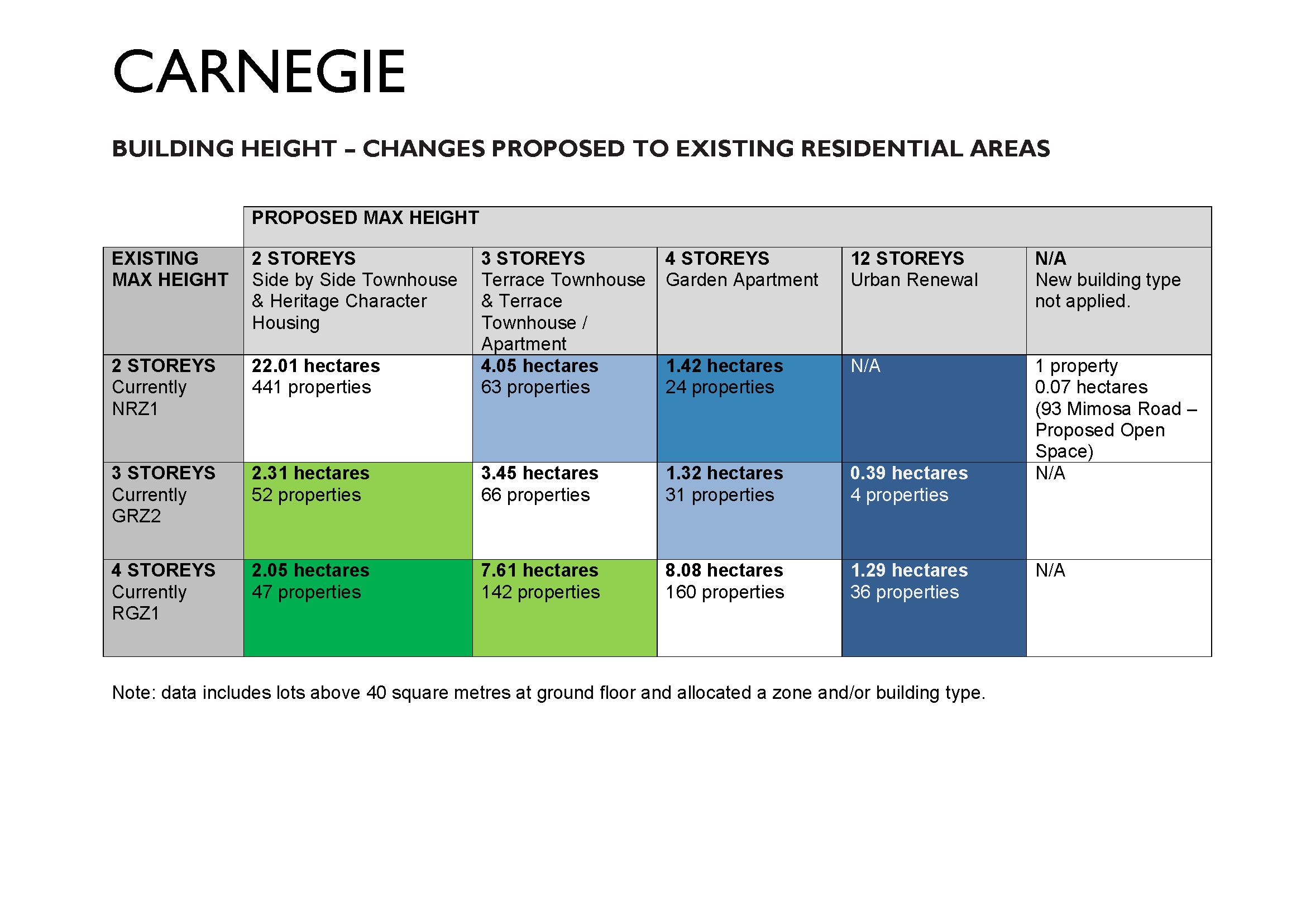
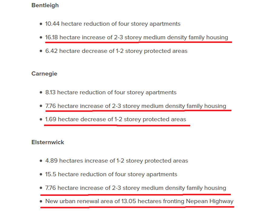
Here is council’s version of the relevant stats for Carnegie and the proposed structure plan – According to the above figure the residents of Carnegie are supposed to be better off in terms of the number of properties rezoned to a lower height. As with the Bentleigh figures, the reality is far different. One example is the rezoning of Elliott Avenue and Tranmere where seven properties on the east side of Elliott Avenue will go from 4 to 3 storeys, and both sides of Tranmere will also be reduced by one storey. Nominally, that should make it 21 properties that will have a reduction in height. Sadly, it is far too late for 14 of these properties which are already set for 4 storey development. (Please note – we are counting the consolidated lots as 2 properties).

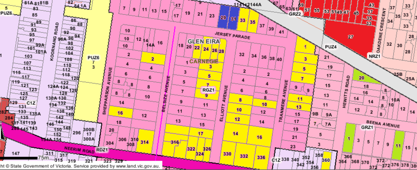
This image tells the full story – post zones.

  • No 1 Tranmere has been to VCAT. Given developers’ past history, there is always the second bite at the cherry by simply reducing the number of proposed dwellings by a handful. It will be back again.
  • Nos. 3 -7 Tranmere are currently up for sale and will have their applications in well and truly before any amendments see the light of day from council! (See: – http://raywhitecarnegie.com.au/properties/residential-for-sale/vic/carnegie-3163/house/1709969 )
  • No.8 Tranmere sold in April 2016, No.6 Tranmere in 2015 & No. 11 Tranmere sold in November 2016. Whilst these properties could possibly remain as ‘owner-occupier’ we don’t like their chances of remaining so given what is happening around them and the potential to make some major profit.

Thus Tranmere & Elliott are GONE, GONE, GONE thanks to what happened in 2013 and no revamping of the zoning at this late point in time is going to alter this fact.

So that readers fully understand the above image here is the legend –

  • Yellow infill means that permits have been granted for 4 storey developments, or will soon have applications coming in for 4 storeys.
  • The dark blue in Jersey Parade is another application currently in for 4 storeys
  • The light green represents other applications and/or permits
  • The red indicates the upgrade from 4 storeys to a potential 12 storeys.

QUESTIONS

  • Given examples like this, how much faith should residents place in council’s figures?
  • What effect will rezoning have if nothing changes in the schedules to the zones and when will council get around to actually doing anything with the schedules?
  • The destruction of these streets has been known for years yet council has tried time after time to avoid undertaking a planning scheme review. This has only happened due to Wynne’s refusal to grant another extension and the order to undertake structure planning.
  • What is the strategic justification for any of these changes? Does it make sense to impose a 12 storey height limit on residents zoned for 4 storeys? We keep hearing the nonsense about ‘right buildings in the right place’ and maintaining a ‘balance’. The only ‘balance’ we can find is an open invitation for more development and the selling off of council land!

PS: we’ve received an email from a resident telling us that nos. 7-11 Belsize Avenue has been sold to a group of developers. Anyone want to take bets on what will happen to this land?

We’ve received the results of a survey conducted by a resident. The findings provide plenty of food for thought that council needs to incorporate into its planning and thinking.

Our thanks to the resident for his time and effort.

Results are uploaded HERE

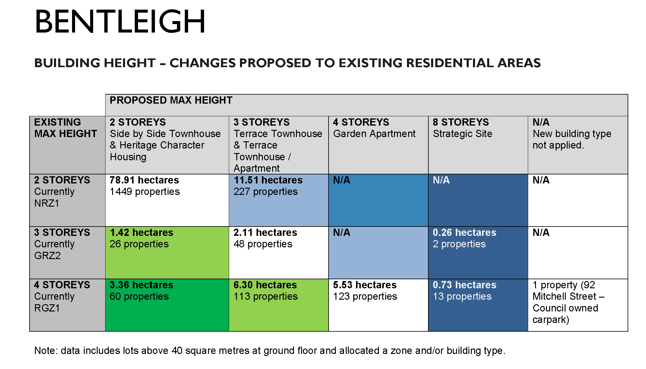
According to council’s own set of figures for Bentleigh (presented below) the proposed changes basically maintain the status quo. That is, there is not too much difference between those properties in line for increased height limits and those areas where height has been reduced.

Adding up all the figures from the table we find that:

  • 243 properties are earmarked for an increase in height, whilst
  • 199 properties are supposedly going to experience a decrease in height

Leaving aside the question of strategic justification for most of these changes, we still ponder whether these statistics really reveal the true stor(e)y (pun intended!). A positive is undoubtedly the rezoning of heritage areas – which implicitly acknowledges the incompetence of what occurred in August 2013. However, the most important issue is whether all of these changes are in fact far too late and what they can achieve? This will of course depend on the resulting amendments and the strength of the long awaited Heritage policy.

A couple of examples should illustrate what we mean regarding the value of some of the proposed changes and how these examples throw some doubt on the figures provided by council.

EXAMPLE 1:

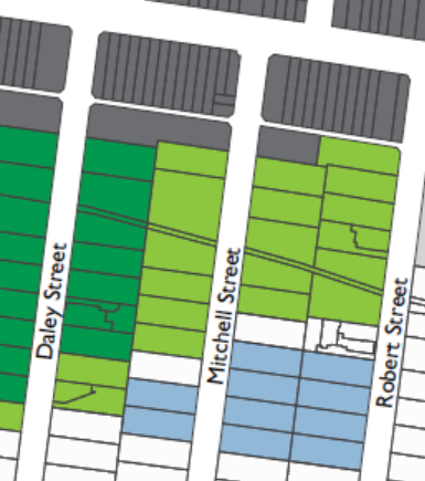
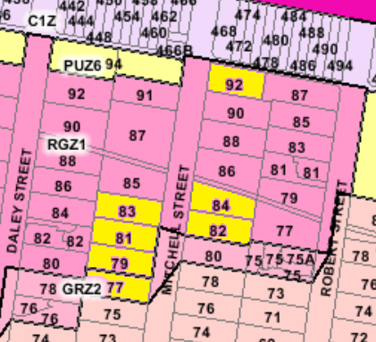
The intention is to rezone 11 properties in Mitchell Street from 4 to 3 storeys PLUS increase another 10 properties from 2 storeys to 3 storeys. But the sticking point is that Mitchell Street already has permits for 4 storey dwellings (nos. 79-83 and 82-84). Number 77 also has a permit for a 3 storey dwelling and no. 92 is probably geared for sale as a council car park. Hence of the 11 properties along this single stretch of road, 6 already are at 4 storeys and another one will go even higher. Thus council’s figure of 199 properties set for a height decrease certainly do not reveal the true storey since no account is taken of what already exists in these figures.

Further, what of the 6 properties going from 2 to 3 storeys in Mitchell Street?  Why are they being ‘upgraded’? What is the purpose, much less the strategic justification? If the intent is to draw a straight line that corresponds with the heritage overlays of Daley Street and Bendigo Avenue, then this hasn’t been achieved. We are still getting a zig-zag line of housing heights that make no sense and contradict council’s claims about trying to avert the radial configurations set in 2013.

EXAMPLE 2:

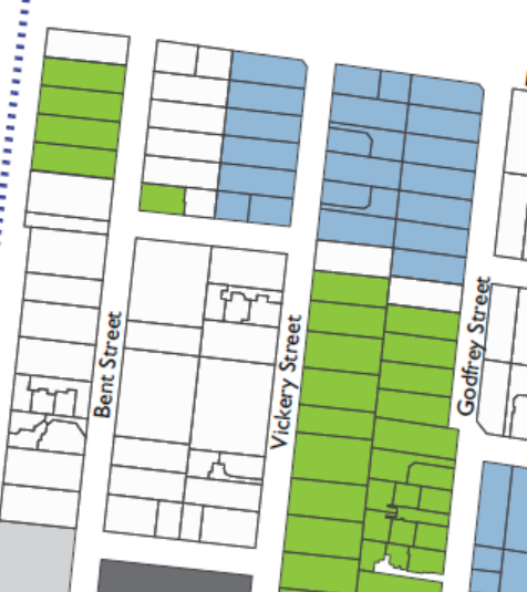
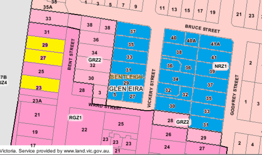
The same issues apply in Bent and Vickery Streets. Council proposes to rezone 25-31, plus 28 Bent Street to 3 storeys (ie 5 properties) and upgrade another 6 properties in Vickery to three storeys from the current 2 storey height limit.  No recognition is taken of the fact that permits for 4 storeys have already been granted to nos. 23,27-29 Bent Street for 4 storey developments. That makes it 2 out of the 5 sites that will be 4 storey. The blue markings in the image following are for the areas designated to now be 3 storeys, up from 2 storeys.

QUESTIONS

Residents really need to start questioning the efficacy, and strategic justification for some of these proposed changes. Is the solution to the current radial set up to simply increase height to the nearest bordering street? Does this really ameliorate the damage already caused or simply invite more damage to residential amenity? How much faith should ultimately be placed in the figures council presents – especially on the downgrading of heights in streets that are already chock-a-block full of 4 storeys. What consistency is to be found across all of these proposed changes? Why are some streets better off than others and why are upgrades along Centre Road so extensive? What does this augur for the eventual revealing of the plans for East Bentleigh? Will we now have entire activity centres blending into each other and stretching from Thomas Street to East Boundary Road? Remember that East Bentleigh is now also being ‘upgraded’ to a ‘larger’ neighbourhood centre – whatever that might mean!

After some considerable pressure from residents, council has finally released its figures on the proposed zoning changes. We’ve uploaded the relevant document HERE.

The emphases remains on meeting government population growth – without of course any mention of current housing happening within Glen Eira. The enumeration of the hectares devoted to the various zones, both current and proposed, is also proffered without any explanation or clear definition – for example: do these figures include roads?

Council is clearly intent on maintaining the mantra that these changes are basically ‘neutral’ – that is, that the overall totals are ‘equitable’. We beg to differ! Once we’ve gone through all the details more carefully we will provide a commentary. In the meantime, here is council’s ‘summary’ –


We’ve received an email from a Carnegie resident who has set up a thoughtful survey on the draft concept plans for this suburb. We urge readers to fill in the survey. Results will be published.

The survey is available from – https://www.surveymonkey.com/r/CCW36FC

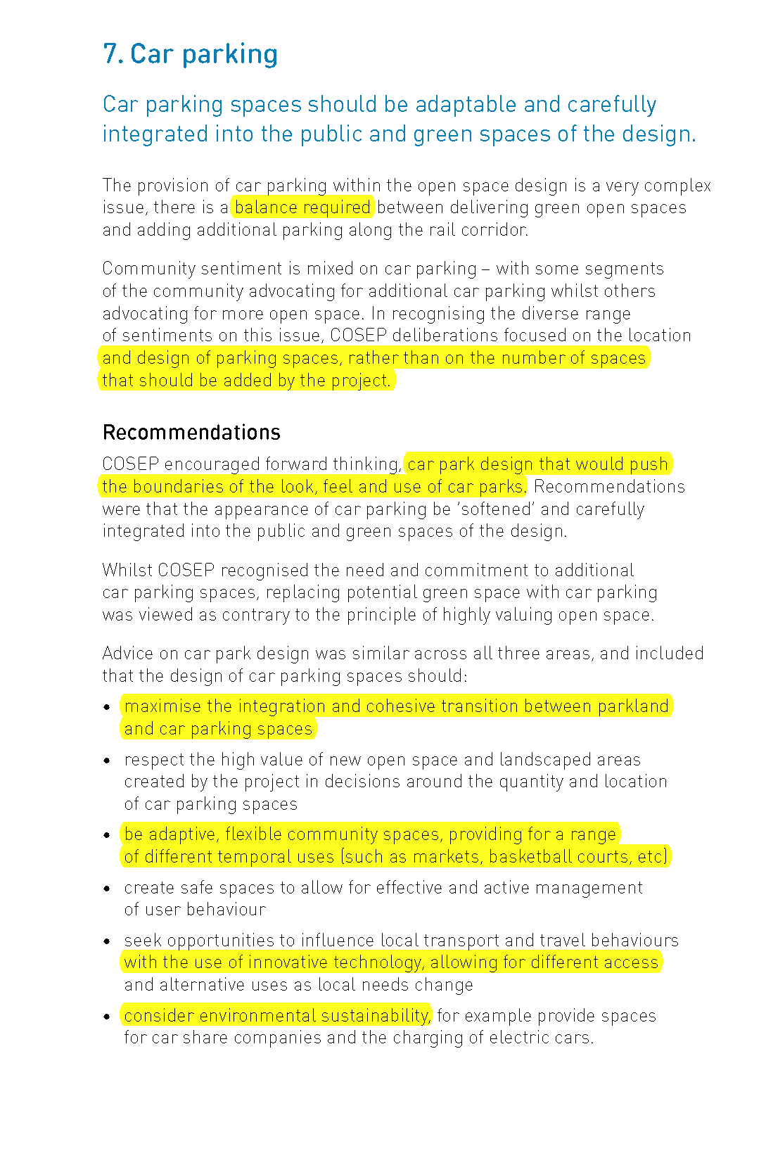
We are well and truly into the era of Orwellian ‘Newspeak’ or to put it more bluntly – weasel words that mean very little but sound mighty impressive to the uninitiated or brainwashed. After months and months of deliberation(s), the so called ‘expert’ advisory panel looking at ‘open space’ along Skyrail has come up with their report.  (UPLOADED HERE).

We find it amazing that any ‘expert’ panel can produce nothing more after months and months than what we find here. Jargon is paramount (ie ‘vibrant’, ‘sustainable’, ‘place making’ etc.) whilst no clear & precise recommendations are the outcomes for the purported 11 MCG’s of ‘open space’.  It’s waffle, generalities, with no definitive outcomes or justifications. Questions of who pays for what, and time frames are of course considered beyond the scope of this report – yet fundamental we suggest!

Below we feature just one page from this report and ask readers to consider what is actually recommended –

Surely it’s not too much to ask that government and council reports, that clearly cost tens of thousands, produce results that are devoid of bureaucratic camouflage, high faluting nonsense, and instead deliver what they are supposed to – recommendations in plain English, and which are all backed up by detail, logic, and ‘evidence’ of some kind of cost-benefit analyses!!~!!!!!

Another great turnout by residents of approximately 100 people. Again butcher paper, facilitator and Aiden Mullen presenting the background, current status and promised future work. There was however about an hour of questions that interrupted Mullin’s presentation. We note once again that the magic words of 12 storey high potential developments were eventually admitted through gritted teeth!

Councillors in attendance: Delahunty, Silver, Sztrajt and Athanasopoulos

Here are a mere sample of the questions asked by residents and the ‘answers’

RESIDENT #1 – One resident asked for hands up from residents, developers, and state government agencies. The vast majority were residents

RESIDENT #2 – When Mullin put up the slide of the Vision for Elsternwick, which still included the word ‘village’, this resident interrupted and stated ‘I am quite frankly struggling to relate that vision plan to the concept plan’. Said that all council’s thinking and what’s presented in the concept plans ‘doesn’t seem’ to endorse the vision statement. Mullin answered that it’s about ‘maintaining that strong cultural and heritage feel’. Mullin then went on with the rest of the presentation – ie spoke about bike connections, and an ‘integrated rail precinct’ and parking ‘opporunities, particularly along Orrong Road’. Said that the ‘fundamental change’ would be ‘creating a new cultural precinct’ near the cinema and ABC studios. Plus the library ‘could be relocated’ to this new precinct. Also said that ‘council’s carparks could have a role in providing more office’ space and employment opportunities (aka flogging off council land to developers is our take on this).

RESIDENT 3 – another resident interrupted and wanted Mullin to explain what ‘community benefit’ means. Mullin responded by saying that Glen Eira is a ‘diverse community’ but developers only build one sort of dwelling – ie 1 or 2 bedroom or double storey attached in the NRZ. ‘The market’ doesn’t do ‘affordable housing, aged care’ and student accommodation and ‘medium density family type housing’. Said that on ‘counciul owned land we can have a lot more control on that’. Resident then wanted to know whether this land would be ‘given to the developer and they produce it’? Mullin responded that there’s a ‘whole range’ of ways this could be done. Resident then persisted with ‘selling council land’ and Mullin answered ‘that is one option’ but that nothing has been decided as yet. The objective is to ‘get something in’ that ‘meets community needs that isn’t being met at the moment’.

RESIDENT 4 – When Mullin outlined that the car park had an 11 storey permit next to it, another resident stated that ‘an 11 storey building doesn’t set a precedent for what is right in terms of development’. Went on to say that ‘someone who wrote these plans missed the church’ and a scout hall both ‘historic buildings’ but the plans have building heights of 8 storeys so ‘what is going to happen to that church’? Wanted Mullin to ‘please explain to me, how does that work out’? Mullin then said ‘I’m trying to get through the presentation and the resident repeated that he would like an answer. When Mullin again said that he wanted to continue with his presentation the resident stated that the evening was about residents asking questions and getting answers from those people who put the plans together. Mullin said that his aim was to ‘take you through to how we got to’ this stage and get your feedback. It’s up to residents to then decide if they ‘agree’. Mullin went on to say that people didn’t want apartment buildings in residential streets and council ‘really’ wanted to protect heritage and the neighbourhood character overlays and these are currently zoned for 4 storeys. Stated that a vcat decision for 8 storeys was given recently in a heritage overlay and vcat is saying that if you ‘lock everything down it has to go elsewhere’. Council was trying to ‘get a better mix’ in housing and in the commercial areas a better mix of employment opportunities like ‘office’.

RESIDENT 5 – said there was no single storeys being built and there was a strong need for this. Wanted to know why this wasn’t in the plans. Mullen said this is because people are trying to ‘protect back yards’ and that with council’s plans for the townhouses they are trying to ensure that ‘living is on groundfloor’.

Mullen went on to say that ‘you can’t lock down everything’ because if ‘won’t get approved by the Minister’. So council is protecting heritage but saying that along the railway line and Nepean Highway this can ‘accommodate’ ‘taller buildings’ which will have an ‘office’ and ‘allow for employment’. This area would be 6-8 storeys but if there was ‘community benefit’ this could be ‘additional car parking’, ’employment’, ‘diverse housing’. The strategic sites ‘can accommodate height behind the shops’.

RESIDENT 6: said that ‘our little court’ disappears from the concept plans but council has ‘rezoned that area’ to ‘be 6 storeys’. Wanted to know why previously it was 4 storeys and now capable of a potential 6 storeys. Repeated that ‘this is in a court and we’re not on Glen Huntly Road’. Mullin answered that he would be ‘happy to discuss’ the matter with the resident afterwards.

CONCLUSIONS?

Once again residents are presented with spin and more spin and no detail, no strategic justifications for anything, and no honest to goodness data. We remind readers that at the Bentleigh forum when asked how many properties were being rezoned to accommodate higher development, Mullen stated that the data would be provided. It is yet to make an appearance!!!!!

Nor have we had a single word to justify why 12 storeys is fair and reasonable. Why not 6 storeys, or 7 storeys, etc. On what basis is the figure of 12 storeys plucked from the air?

There is much, much more that could be said. We will simply reiterate our conviction that decisions are already set in concrete and that these forums have been nothing more than a public relations exercise designed to meet state recommendations for ‘community consultation’ when doing structure planning.
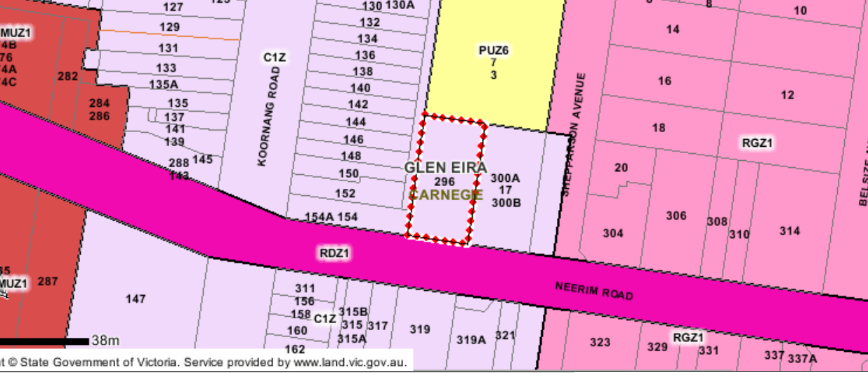
Council never fails to surprise when it comes to open space. The announcement that they have purchased a site in Neerim Road, Carnegie is, in our view, a mixed blessing indeed. Whilst we have consistently argued that it is Carnegie that requires a huge investment of funding for open space, we also query the motives behind this purchase.

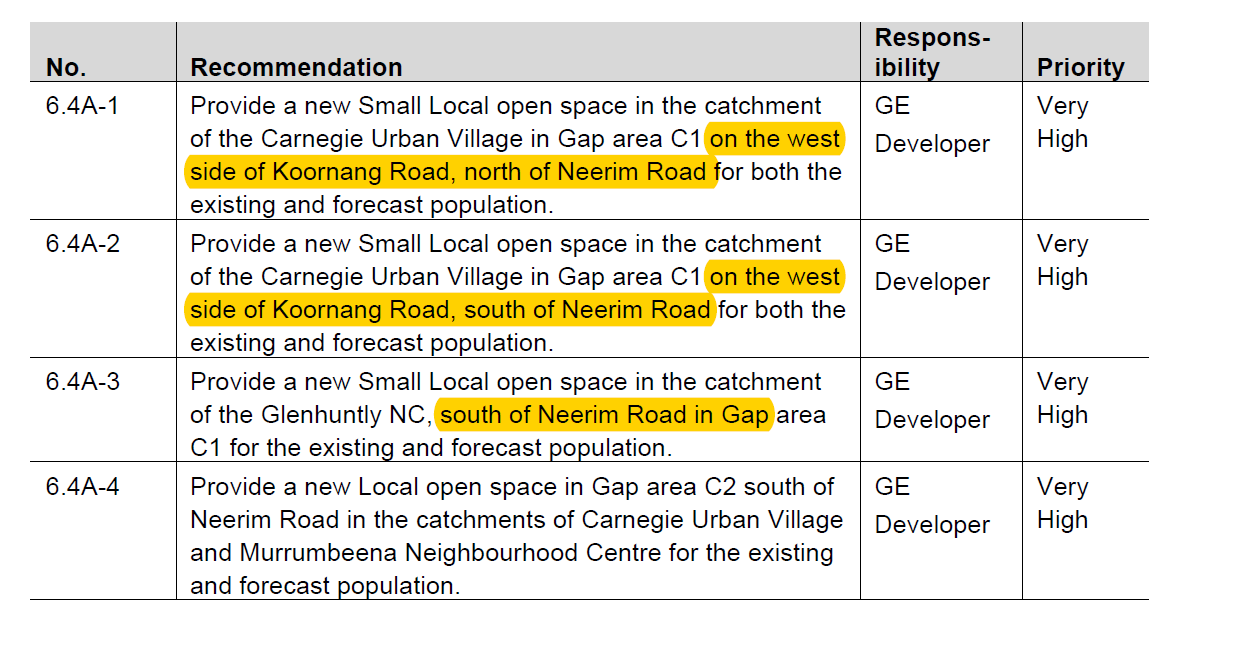
Residents have been repeatedly told that council’s rationale for all its open space endeavours is based on the 2014 Open Space Strategy. Well, unfortunately, this particular purchase is at odds with what the OSS recommends. The ‘expert’ recommendations were for the purchase of land on the WEST SIDE of Koornang Road. This property is on the east. See the two images below –

Points to consider:

  • Will this purchase become the $3.61 million reason to ram through the sell of council’s carpark and set the stage for 8 storey developments?
  • Neerim Road itself is hardly a ‘pedestrianised’ street. It is full of high density dwellings already. Thus access from Neerim Road itself would certainly be limited
  • Residents on the south side of Neerim are also ‘disadvantaged’ given that the OSS decries the creation of open space that necessitates the crossing of major roads.
  • The crucial question of course is what does all this say about council’s intention to first listen to the community and then to act on the community’s views. If this sizeable amount of money has already been signed off, then what prospect is there that if the community doesn’t agree with the sell off and ‘repurposing’ of council land, that residents will be listened to? Or is 600 square metres in the most noisy, and inaccessible position, plus being overshadowed by 8 storey dwellings, all that residents can hope for?
  • Finally we again question the consistency and value of any council ‘policy’ when it can function to justify any decision when council so pleases, and then be ignored – also at council’s whim and hidden agendas!

The Elsternwick draft concept plans are ‘interesting’ to say the least.  First off there is the admission how badly this council and its zones architects stuffed up in 2013. When an activity centre has so many areas covered by Heritage Overlays, Newton, Akehurst, Hyams, Delahunty, Magee and Esakoff, all saw fit to go ahead and allow these areas to be zoned as Residential Growth Zone (RGZ). Thankfully the current plans attempt to redress this incompetence. However, they do a lot more ‘damage’ elsewhere in another example of clearing the ground for major high rise development!

Here is a summary of what is proposed –

  • As with Carnegie, the central shopping strip will have 3-4 storey (orange) but some of this strip will allow 8 storeys directly behind Glen Huntly Road (ie Sinclair and Beavis Streets) which abut heritage areas. Thus like Carnegie, heritage areas will be overshadowed by anything up to 8 storeys.
  • Several heritage sites along Nepean Highway will be, as with Carnegie, directly overshadowed by 12 storeys
  • The ‘borders’ of the activity centre have, like Bentleigh, mushroomed out to practically double the size – now extending to Glen Eira Road.
  • Ripon Grove and Gordon Street will now also become 8 storeys (from the current 4 storeys) and once more they sit alongside Heritage areas.
  • The most startling changes will occur all along Horne Street to Nepean Highway. These sites can now become 12 storeys – again encircling previous NRZ zones that are now upgraded to 4 storeys.
  • The amount of land now given the go-ahead for 12 storeys is alarming!
  • Possibly the most important change is the inevitable rezoning of those areas currently marked as C2Z to Commercial 1. This would allow residential and the height proposed is 12 storeys (ie along Nepean Highway).

The map below shows one example of what is envisaged. The yellow markings indicate some sites which are now being upgraded from 2 storeys to 4 storeys.

We’re focusing on one tiny corner of the Carnegie plan this post as the perfect example of planning gone mad. With typical double speak nonsense, council tells residents that they are concerned about ‘transition’ – we even get titles like ‘Building Transition Plan’.  We urge all residents to carefully consider the following and at tonight’s public relations exercise at Carnegie to really hone in on this lunacy.

Here’s what the above image reveals:

  • Rosstown Road ‘upgraded’ to 4 storeys from 2 and now abutting some remaining 2 storeys to the South-West of Rosstown Road.
  • The ‘pink’ coloured areas in Egan and Arawatta (up to 12 storeys) enclose ‘heritage character/shop top’ of 3 to 4 storeys
  • These ‘pink’ areas of 12 storeys also overshadow Chestnut Street (heritage overlay) of 1-2 storeys.
  • To the north of Chestnut we again have 4 storeys along Dandenong Road overlooking 2 storeys.

When all of council’s propaganda for the past 4 years has been about protecting the community via appropriate transition (ie 4 storeys, down to 3 storeys, down to 2 storeys via RGZ, GRZ1 & GRZ2 respectively) to now come up with this nonsense is literally beyond belief. It is even more unbelievable that such plans could even get off the ground and be put up for ‘consultation’. Who is responsible for this? Where is the strategic justification? What secret deals have already been made with developers and/or governments? And how on earth can 9 councillors even come close to believing that this is worthy of consideration by ratepayers? We would also question how much of ratepayer’s money has been spent on ‘consultants’ and producing glossy flyers, letters, and brochures that are nothing short of embarrassing!

« Previous Page — Next Page »