GE Service Performance


lettersmagee


Ed Booth’s appeal for ‘actions not words’ is lost on Magee and his fellow non-representatives of the community. Instead there is the usual spin, mistruths, and pure bunkum. Perhaps if neighbourhood character was so important to Magee and this council, we may have had ‘preferred neighbourhood character’ statements in the planning scheme for housing diversity. They don’t exist, which results in the following images for Vickery Street, Bentleigh. A four storey monster containing 47 dog boxes is set to replace Californian bungalows. Yes indeed, Council really cares about neighbourhood character, and how street after street is being destroyed!

IMG_20151117_195228330

IMG_20151117_195356648

Readers may remember the Kangaroo Road application for the extension of a physiotherapy practice from 2 practitioners to 5 practitioners. It just happens that this practice in Kangaroo Road, Murrumbeena is owned by the husband of one of Glen Eira’s Strategic Planners. The applicant for this application was a former planning officer at Glen Eira.

The officers recommended a permit, but councillors knocked it back. The primary reason is that according to council’s planning scheme (non-residential uses in residential zones) such permits should only be granted for dwellings on major roads. Kangaraoo Road is NOT DESIGNATED as a major road and was the major stumbling block in receiving a permit.

Well, lo and behold, if council isn’t NOW doing a traffic survey of the street. Coincidence? Or is this an attempt to change the status of Kangaroo Road and make it possible for the application to get approval? When other residents wait for years to have their streets monitored, it is truly amazing that this road suddenly comes out of the woodwork. Thus, if Kangaroo Road now joins the ‘big league’ of major roads, all obstacles to the permit disappear. Or even if an amended permit comes in, readers should remember that these applications usually do not go to council but officers make that decision! How convenient!

So questions galore with this one –

  • After years and years of neglect, suddenly there is the need for a traffic assessment?
  • If the owner of the property was anyone else but a staff member’s husband and the applicant a former employee would this administration run out and do a traffic report for ordinary Joe Citizen?
  • Why can’t the applicant simply go to VCAT – or would this bring out all the potential dirty linen as to how a permit for a physio centre was granted in the first place?

Whilst not as bad (yet) as Carnegie, East Bentleigh isn’t too far behind in terms of over development and transforming the suburb completely. Readers need to bear in mind several important facts –

  • East Bentleigh is not a Major Activity Centre – it is designated as a Neighbourhood Centre
  • It is not within cooee of adequate public transport
  • Virginia Estate redevelopment is probably just around the corner adding thousands of new dwellings
  • East Bentleigh, despite the fact that it is NOT a major activity centre, has one of the highest land masses zoned as ‘commercial’ – meaning no height limits, and no other protections for the neighbourhood such as Design & Development Overlays, Parking Precinct Plans, Structure Plans, Urban Design Frameworks, etc.
  • It also has the largest area zoned RDZ – meaning 3 storeys

Below are two images that should be viewed in conjunction and that attempt to capture some of what is happening since the secret introduction of the zones without any community consultation. We have not included all that is occurring – ie applications galore for other streets such as Browns Road, Elizabeth St, and of course East Boundary Road itself and the streets coming off this road to the East. Like all planning in Glen Eira, everything has been handed over to the market and the market (and therefore Council) does not care one iota for residential amenity. That philosophy represents negligence of the highest order.

CLICK TO ENLARGE IMAGE

east bentleigh

and the continuation to the North

EB

We’ve received more photos and a video of some incredible and illegal manoeuvrings of a double loader in Carnegie. The photos provide another angle for what is happening. It is truly amazing that every car and pedestrian remained intact.

IMG_3824 IMG_3825 IMG_3827


We’ve received several sets of photographs from alert residents. Once again, safety and enforcing the law would seem to be beyond council’s priorities. What is also unacceptable is that accompanying one of these photos was this comment in response to the fact that the image was not 100% clear – I have been physically threatened by a truck driver illegally parked on same location before and chased up the street with him demanding my phone to remove the photo. I am very wary of being seen taking photos. Whilst residents report countless incidents, nothing changes. Developers own the streets, footpaths, and driveways!

These two photos show illegal parking right on the kerb thereby forcing drivers making  a left hand turn smack into the middle of the road and possible oncoming traffic –

IMG_3802

IMG_3800

Next there is the illegal parking facing the wrong side of the road plus another illegal parking across a resident’s driveway.

IMG_0166

IMG_0164

135

278

365

end

CLICK ON IMAGES TO ENLARGE

Above are 4 screen dumps of Neerim Road and what has been happening since the introduction of the zones. Each image represents a continuous stretch of road. Different colours are used for each application and indicate whether the proposed development extends over a single or ‘consolidated’ site. The numbers are for permits already granted or awaiting decision.

What is completely mind boggling is that the total number of apartments to be built along this single road since 2013 equals 548. Unbelievable! Thus, if 225 dwellings are built per year, then this represents more than 50% of what the planning scheme says is the average number of dwellings required per year until 2021! And all in one street!

How can a council allow this to happen? What studies have been done of ‘capacity’? Do they know? Do they even care? How much money will ratepayers have to fork out to supply additional drainage and other infrastructure? How much has already been spent on drainage and how much more needs to be spent? Has Council any idea or is this more pie in the sky planning based on no factual data and analysis? What guarantee do Carnegie residents have that they will not be at increased risk of flooding or that subterranean car parks will ultimately impact on the water table causing other major problems? In our view, Council’s incompetence is only exceeded by its indifference to its residents.

Here’s the full list of what’s presented in the images –

135-137 Neerim Road GLEN HUNTLY VIC 3163 – 3 storey, 39 dwellings

143-147 Neerim Road GLEN HUNTLY VIC 3163 – 3 storey, 30 dwellings

149-153 Neerim Road & 4 Hinton Road GLEN HUNTLY VIC 3163 – 17 double storeys

167 Neerim Road CARNEGIE VIC 3163 – 2 dwellings

179 – 181 Neerim Road, CARNEGIE VIC 3163 – 3 storey 19 dwellings

212 Neerim Road CARNEGIE VIC 3163 – additional dwelling to rear

247-251 Neerim Road CARNEGIE VIC 3163 – 4 storey, 48 dwellings

253-255 Neerim Road CARNEGIE VIC 3163 – 4 storey 30 dwellings

257 Neerim Road CARNEGIE VIC 3163 – 3 storey, 7 dwellings

259-261 Neerim Road CARNEGIE VIC 3163 – 4 storey 28 dwellings

276-280 Neerim Road CARNEGIE VIC 3163 – 5 storey, 48 dwellings

315-317 Neerim Road CARNEGIE VIC 3163 – 7 storey, 26 dwellings

322-326 Neerim Road CARNEGIE VIC 3163 – 4 storey, 40 dwellings

328-330 Neerim Road CARNEGIE VIC 3163 – 4 storey 16 dwellings

332-334 Neerim Road CARNEGIE VIC 3163 – 4 storey 36 dwellings

339-341 Neerim Road & 19-21 Belsize Avenue CARNEGIE VIC 3163 – 4 storey, 52 dwellings

363R Neerim Road CARNEGIE VIC 3163 – 3 storey, 4 dwellings

331-333 Neerim Road CARNEGIE VIC 3163 – 4 storey, 26 dwellings

365-367 Neerim Road CARNEGIE VIC 3163 – 3 storey, 16 dwellings

401-407 Neerim Road CARNEGIE VIC 3163 – 5 storey, 63 dwellings

479 Neerim Road MURRUMBEENA VIC 3163 – 2 double storeys

TOTAL = 548 DWELLINGS AND THIS DOES NOT TAKE INTO ACCOUNT WHAT IS HAPPENING IN ALL THE LOCAL STREETS RUNNING OFF NEERIM ROAD – IE ELLIOTT AVENUE FOR EXAMPLE!

PS: congratulations to the residents of Claire St, McKinnon. VCAT has refused a permit for the three storey development. We have uploaded the judgement HERE. Readers should take careful note of the member’s comments. The development was refused primarily because of developer greed and not thanks to council’s planning scheme restrictions. We also have to speculate as to the role that massive tv, radio, and press coverage had on this outcome. Perhaps a lesson for all residents? The problem of inept zoning and schedules still remains!

letters

Mr Booth’s comments are surely warranted when we analyse what has been happening in Glen Eira. There has been a remarkable drop off in the number of applications that come up for Council decision. The reason isn’t less applications, but the fact that Council is now refusing outright via manager or through the Delegated Planning Committee process, application after application. Why? So that council can continue with its nonsense such as blaming VCAT for everything instead of doing what it is paid to do – implement a planning scheme that is worthy of that name.

We have commented numerous times here on the ridiculous decisions made by council planners. Either the application is refused, or conditions imposed that have no hope of getting up because they are not supported by the planning scheme. The latest example is a VCAT decision for 130 Murrumbeena Road, Murrumbeena. It is zoned GRZ1; is within the Neighbourhood Centre; is less than the 10.5 metre height maximum, and proposes 16 dwellings on a 880 square metre block.  Council refused the application and VCAT granted a permit. What residents need to appreciate is:

  • according to the planning scheme there was no logical reason to reject this application
  • the imposed conditions are not supported or even part of the planning scheme
  • Result? More ratepayers money thrown down the drain so that council can pretend it is doing its job properly!

Please consider the VCAT member’s comments carefully and then decide who is the real culprit – VCAT or Council? Mr Booth’s comments of ‘hiding behind VCAT’ are indeed appropriate!

Council says that local policy requires a transition in height and scale from the commercial centre to the edge of the housing diversity area. It says a three storey building on a site near the outer edge of the activity centre does not respect the transition that is sought. Consistent with the Tribunal’s findings in Pitard Knowles Pty Ltd v Glen Eira CC, I am not persuaded by this proposition. The preference for a transition in scale is one of many strategies in clause 22.07 and it has no more or less weight than the others. It must be applied contextually. There is no guidance in clause 22.07 as to where a transition applies. Is it halfway between the core and the outer boundary, or two thirds or another distance from the centre? Is it to be defined by streets? What is required in transition in height, and from what? Does the transition also apply to front setbacks, width of facades, landscaping, fencing and streetscape rhythm. The general policy is unhelpful in this matter, and Council has not prepared urban design frameworks or Overlays that might have provided greater guidance.

The little guidance on the matter of transition is provided by the distinction between the schedules to the GRZ. Schedule 2 to the GRZ is a transitional area because the maximum height in the GRZ is lower than the GRZ1. It is notable that the GRZ2 applies only to lots that directly adjoin land in the NRZ, and it applies to land of one lot in depth. Council has effectively defined the area where a transition in height and massing might be expected to be only the lots at the outer edge of the GRZ1 area.

ON SETBACKS TO UPPER LEVELS

Secondly there is no policy basis, urban design framework or DDO that requires a recessed second level, and the building would be lower than the maximum height allowable under the schedule to the zone. Requiring a setback would be arbitrary and it does not respond to any clear built form or policy directive or amenity consideration

Source: http://www.austlii.edu.au/au/cases/vic/VCAT/2015/1729.html


bent st

PS – AND WE MUSTN’T FORGET THE DISASTER THAT IS NEERIM ROAD!
neerim

Please consider the lists provided below which highlight the various amendments that neighbouring councils have initiated in the past 2 years – since the zones came in – in contrast to what Glen Eira has produced.

BAYSIDE

Amendments c112-115 – introducing mandatory height limits into activity centres (ie includes commercial as well)

Amendment – c121 – extending their Water Sensitive Urban Design policy

Amendment C139 – Development contributions levy

Amendment C140 – Bayside Housing Strategy of 2014 & subdivision size of land

And plenty of new heritage overlays on various properties and areas

BOROONDARA

Amendment C108 – permanent Design & Development Overlays in many areas

C109 – extends interim height controls for Neighbourhood Centres (ie includes commercial)

C139 – more structure plans and design and development overlays

C149-C152 – more heritage overlays

C152 – Maling Road ‘building form guidelines’

C229 – amends council’s LPPF (local planning policy framework)

STONNINGTON

C153 – design and development overlay

C154 – Chadstone expansion includes Incorporated plan for the land

C155 – development overlay for heights along Yarra

C168 – 2 new Neighbourhood Character overlays and development overlays

C172 – Chapel Revision Structure Plan

C175 – updates Municipal Strategic Statement plus new neighbourhood character policy

C177 – environmental sustainability design

C180 – public acquisition overlay

C181-184 – various heritage overlays

C185 – 2 new Neighbourhood character overlays, design and development overlays and their integration with zoning for GRZ sites

C186 – open space levies where 4 suburbs are paying 8% – South Yarra, Windsor, Prahran, etc

Many new heritage overlays here.

C212 – Malvern Road Neighbourhood Structure Plan

C217 – more significant character overlays

C220 – extension of structure planning controls for Windsor, Prahran, South Yarra

GLEN EIRA

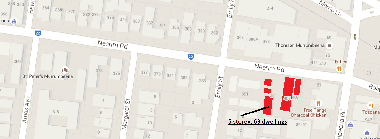
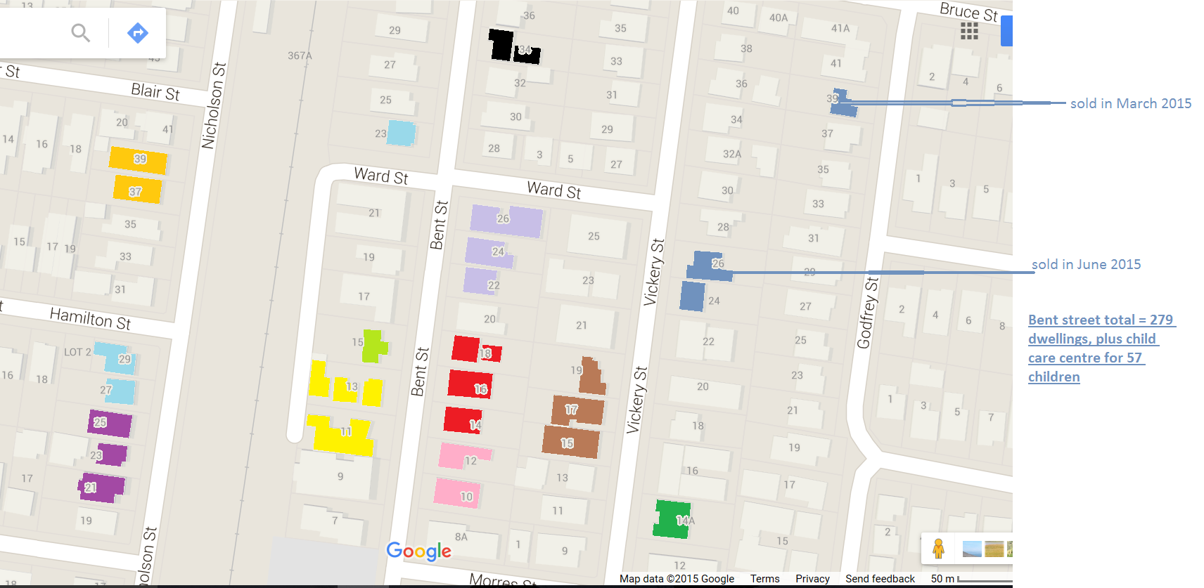
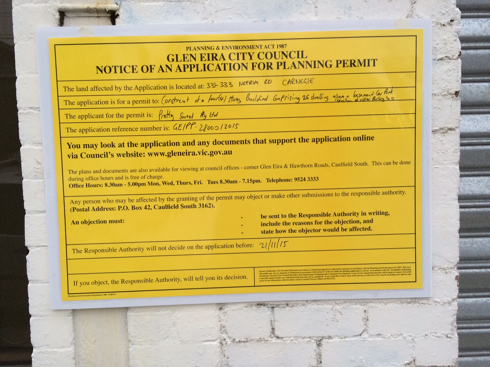
C100 – Rezones Industrial 3 To Mixed Use Zone (Neerim/Emily St)

C102 – Revises Non Residential Uses In Residential Zones Policy

C107 – Neighbourhood Character Overlay (Schedule 2) To Moodie St., Caulfield East

C113 – Heritage Overlay On Some Sites In Caulfield North

C120 – Open Space Levy Of 5.7%

C121 – North Road Sites From Commercial 2 To Mixed Use Zone

C123 – Updated Child Care Policy

C130 – Environmental Audit Overlay In Glen Huntly

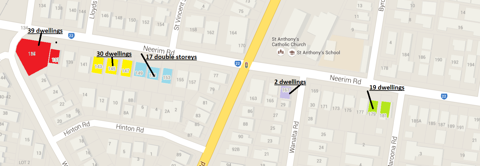
C135 – Public Acquisition Overlay On Magnolia Road

C139 – Rezone Glen Eira Rd/Hotham St Corner From Commercial 2 To Mixed Use Zone

C140 – Public Acquisition Overlay On Mimosa Road/Mile End Road

AND THE ATTEMPTED VIRGINIA ESTATE AMENDMENT THAT WOULD YIELD 4,600 DWELLINGS!

COMMENT

  • Rezoning to MUZ or Commercial means more residential high rise
  • Magnolia Road public acquisition overlay was gazetted in August. Three months down the track and the property still hasn’t been purchased for open space. There was a public acquisition on this property for years, then removed in 2008, and then re-imposed. Superb planning and now we fear that council simply does not have the money to purchase anything.
  • ‘reviews’ of child care policy and non-residential uses, simply changes the playing field – now making it easier for such developments to encroach into Neighbourhood Residential Zones.
  • Planning Panels have recommended a total review of Heritage. The current policy dates back to 1996. Another museum piece!

Conclusion? Whilst other councils have been busy shoring up their defences against over-development, and rejecting Planning Panel decisions and pushing ahead for Ministerial approval of their amendments, Glen Eira continues in the same old fashion – tinkering and avoiding anything that might constitute an obstacle to development.

For months now, some councillors have been voicing concerns about Glen Eira’s planning scheme, the zones, the way they were introduced, plus the lack of necessary ‘tools’ that council could use in determining applications. Residents themselves have taken to social media, with petitions, comments, and demands. We have consistently reported on VCAT decisions that make it abundantly clear how inept and lacking Council’s planning scheme is. People are angry and getting angrier at what they see as the destruction of their neighbourhoods and their lives.

So how do our councillors respond to this ground swell? More empty talk, more ‘we should do this’, but absolutely, no firm action from any of them! Words are cheap and ultimately useless. What is required is a simple council resolution which orders the pen pushers to get off their backsides and to immediately put the planning scheme on the table for intense and full, honest consultation with residents. Or will we continue to have more hand wringing, more crocodile tears, more blaming of VCAT, more ratepayers’ money being thrown down the drain with public relations disasters intended to excuse 13 years of negiligent planning under Newton?

Tuesday night provided some further examples of ‘we should’. As we’ve already said – talk is cheap. It is now, with the election year looming, time for action! Here’s a report on some of the comments that were made on several items.

LOBO – thought that it was time to ‘review policies’ following Plan Melbourne’s release and how the government is expecting over 7 million people in Victoria. Said it was also important to ‘review our Municipal Strategic Statement’ that ‘was adopted by council on 17th May 1999’, and accepted by the government on 5th August 1999, 16 years ago’ and in ‘light of the boom and new residents’.

SOUNNESS: said he was ‘concerned’ that even though the VCAT member rejected the 16 storey application in Egan St., Carnegie, he still stated that the height was acceptable. This then leads onto the question of an urban design framework that looks at traffic, “what’s the shape of a city’ and where density should go and ’16 storeys doesn’t meet that criteria’. And there is also a paragraph in the VCAT member’s judgement that notes ‘the absence in the scheme that provides guidance about these areas’. The decision then talks about ‘first principles’ and the design guidelines for high density developments. There is also discussion about how the Carnegie area is ‘undergoing substantial change’. He is pleased that the application was refused, but strictly on amenity design and ‘not the other features’. For him ‘a village is not 16 storeys’. ‘I have some concerns about how council’s policy framework is directed’ and that there is a ‘due process to go through in reviewing planning schemes’ and for those sections in the planning scheme that involve ‘urban villages’. He ‘hopes’ that there can be a ‘conversation about that earlier rather than later’ because if these sorts of applications for 16 storeys comes in then they are not appropriate.

HYAMS: also didn’t think that 16 storeys was appropriate and that ‘Mr Torres has assured us’ that this is against the ‘policy for the area’. Also if VCAT is ‘incapable of interpreting our policy’ then maybe there needs to be ‘policy that VCAT can understand’ so there is some ‘work that we need to do’.

We remind readers of the following facts:

  • The Planning Scheme was allegedly ‘reviewed’ in 2010. This was, in our view, not a real ‘review’, but a predetermined decision to do very little except tinker with the edges.
  • Council (or some anonymous officer with no delegated authority) applied for an extension so that more years could pass before the scheme was touched again. There was no council resolution on this and no rationale for why another two years of delay was sought. The Minister granted council an extra year.
  • That would take any review well into 2017 – plenty of time for suburbs, streets, and amenity to be ruined.


« Previous PageNext Page »