Page two of council’s damage control exercise (ie the Apartment Boom letter) purportedly sets out all of the fabulous things that council is doing for its residents. It is a pity that careful phrasing and half truths dominate instead of real facts. We ask readers to consider each point. The Council statements are in italics.
- Council is managing the boom within the limited powers given to us by state authorities.
One might quibble as to the definition of ‘limited powers’. Whilst it is true that there is much in all planning schemes set by the government, it is also true that close to a third of all planning schemes are handed over to councils to determine – they simply must support their proposals with sound empirical evidence. Councils are free to introduce structure plans, heritage overlays, design and development overlays, infrastructure levies on developers, open space levies, parking overlays, preferred character statements, up to date housing strategies for each precinct, and of course, the schedules to all the zones, and to determine where the zones go. We note that Glen Eira (contrary to other councils) has never had anything approaching real structure planning; it has 6 piddling design and development overlays – 3 of which regulate fence heights in a handful of streets and another two facilitate higher development in 2 specific areas. The Municipal Strategic Statement dates from 1999 and now belongs in a museum! Promises made centuries ago have never materialised. For 8 years council was content to extract a pittance for open space levies, knowing full well that the municipality was highly lacking in open space. Council also never bothered to ‘renew’ its lapsed development contributions levy so that now residents are subsidising developers completely for drainage. There is thus plenty that is within the power of council to initiate and deliver. They have simply refused to do the basics that every other council has done and which the State Government expects – ie structure planning and decent strategic planning.
- We obtained government approval for maximum height limits over all residentially zoned land where there were no limits before.
The veracity of this statement depends on how one defines ‘residentially zoned land’. According to the planning scheme the Mixed Use zone (MUZ) is also labelled as ‘residentially zoned land’. Hence Council has not imposed maximum height limits on all residentially zoned land as they would like residents to believe. One could go even further and argue that today Commercial zones are de facto residential zoned land – especially when developers can build one or two shops and then put 100 units on top of this! It is also worth noting that Boroondara has managed to achieve a three storey height limit for its Neighbourhood Centres including the commercially zoned shopping strips and other councils are following this lead. In Glen Eira, no such thing exists, and even worse, all Local Centres are now zoned Commercial and the vast majority directly abut Neighbourhood Residential Zones.
As to the ‘no limits before’ statement – again a misrepresentation. There were limits, albeit, ‘preferred’ height limits of 9 metres. So what does council do with the zones? Accept and impose the absolute maximum of 10.5 and 13.5 metres and no height limits whatsoever for the Mixed Use Zone. A ‘one size fits all’ approach across the board. Sloppy planning indeed when seen in light of other councils and the number of GRZ and RGZ zones each applied and the height variations within each of the schedules. This of course required some hard work and a close analysis of the municipality – something entirely alien to this council.
Height limits by themselves do not of course make for good planning and protection of residential amenity. Especially not when there are no urban design frameworks to accompany the height limits and no real provision for open space, permeability, no tree protection, and no preferred character statements for Housing Diversity areas. We remind readers that other councils for both their GRZ and RGZ zones have managed to achieve far greater protections in terms of open space and permeability than Glen Eira. Some councils (ie Yarra) have even managed to have the Residential Growth Zones removed entirely and Bayside is also awaiting approval for this to happen in their municipality.
At the time of introducing the zones, Council had the choice. Schedules were there to be fine tuned. There was no fine-tuning. Simply a total cave in. Our question always remains the same – if other councils could get a better deal for their residents then why couldn’t Glen Eira? How hard did Newton, Akehurst and Hyams really try? Or were they so caught up with the self promotion of being the first council that all thought of getting the best deal went out the window?
- There is nothing under the new zones that could not be built before
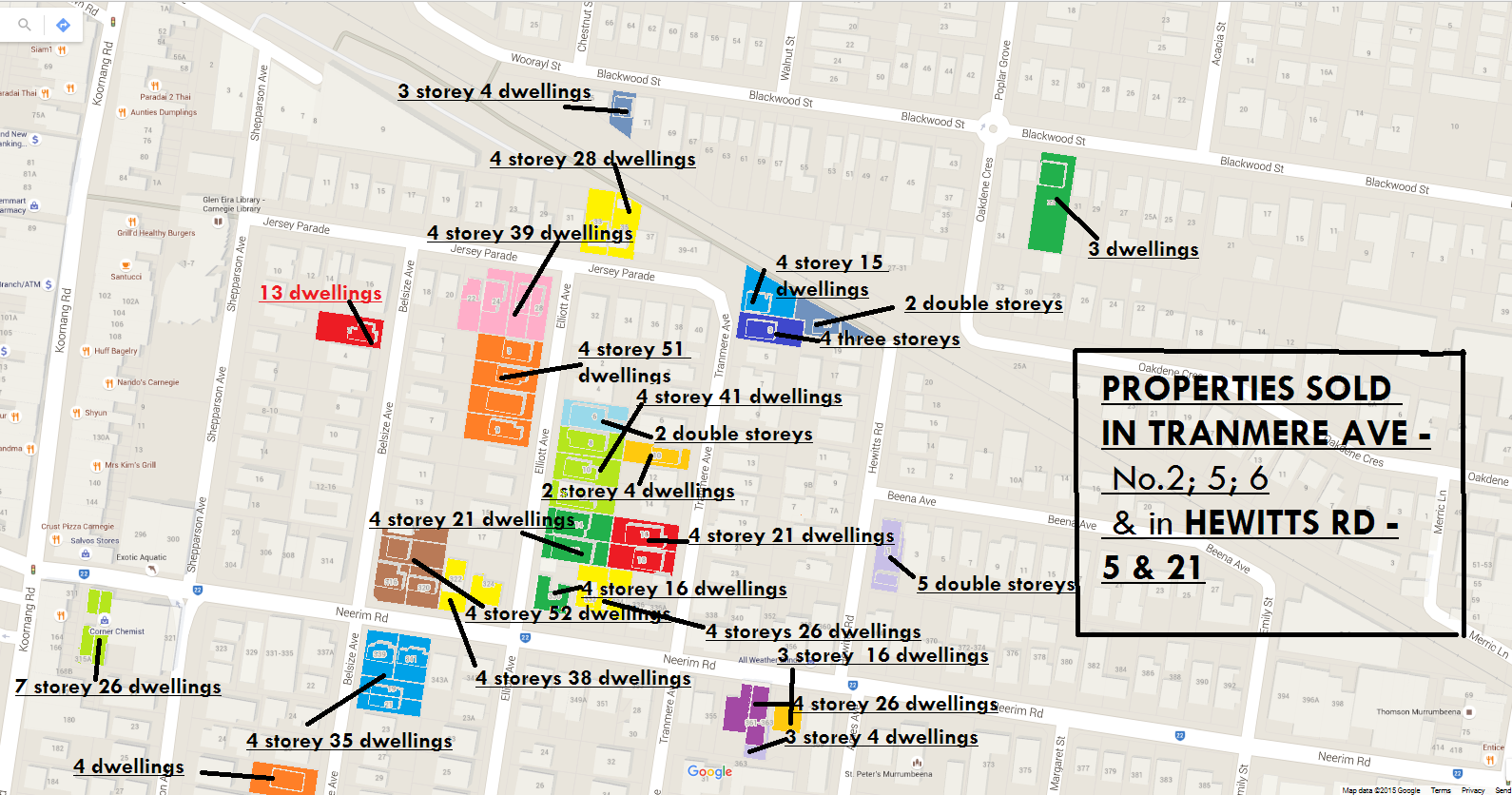
A nice little slogan! The point is that PRIOR to the zones, developments were far more constrained and those applications which did get through (particularly in Carnegie) were also the result of a poor and ill-defined planning scheme. The loopholes that exist now, existed then. The difference however is that cometh the new zones, developers, investors, and real estate agents were given the clear signal that they could now build to their hearts content and instead of a 9 metre preferred limit, they could now literally go for 13.5 metres in RGZ and 10.5 metres in GRZ. That’s why we are now seeing amended application after application seeking the limit. One perfect example is 20 Wheeler St., Ormond. On the 21st May 2013 an application went in for 2 double storeys. On the 12th December 2013 an amended permit went in for changes to windows. Then on the 21st February 2014, a new application came in for 8 double storey dwellings. Council refused this application so we now get another application (15/10/2015) for seven dwellings on land that is roughly 760 square metres and zoned GRZ1 and this includes a combination of three and two storey buildings. Needless to say there is no minimum lot size for subdivision in Glen Eira, whilst Bayside is aiming for a minimum of 800 square metres and other councils have a range from 350 square metres per lot – ie Manningham
There’s also this beauty for 249 Neerim Road, Carnegie. In September 2011 an application went in for three storeys and 11 dwellings. It got a permit. Then in June 2015 another permit was issued for 4 storeys and 48 dwellings! Of course Council would like us to believe that this has nothing whatsoever to do with the zones
Even VCAT prior to the zones would pay close attention to the ‘preferred’ height limits. From a decision in 2011 on George St., Caulfield North –
The Council and Mr Durrell asked for the building to be lowered to 9 metres to meet Standard B7 (and consequently Standard B17 with respect to the western elevation) and to provide a better transition from the larger and higher form on the north side of George Street. ….. I consider lowering the building is a necessary together with other modifications as referred to in these reasons. I appreciate the scale of development opposite the site but am also mindful that land differs from the review site. The review site is small, has different building relationships, and has different visibility in the streetscapes and from adjacent confined lots. Further, it is influential to my conclusion that the change will assist to bring the development into compliance with Standard B17 with respect to the impact on No. 3 George Street
Compare the above (and council’s attitude) to what we now have. A VCAT decision from September 2015 –
There is no Design and Development Overlay or other overlay, or indeed a policy, to indicate the preferred heights for new multi-dwelling developments in the residential area. What guidance is available is obtained from Schedule 1 to the General Residential Zone, which specifies a maximum height of 10.5 metres for a building on this land. This height can comfortably accommodate three-storeys of residential development. Accordingly, the Council, through its Planning Scheme, has made a conscious decision to allow for three-storey development on this site. Indeed, the Council advised that it has no ‘in-principle’ objection to a three-storey building on the review site
Bent Street Bentleigh is another example of amended permits seeking an additional storey increase and more apartments to permits that had already been granted. Again, the VCAT member’s comments on what the zones really mean –
….there has been a change in planning circumstances, notably the zoning of the land has changed from Residential 1 Zone to the current General Residential Zone Schedule 1, which contemplates more intensive development where height of building can be 10.5 metres and up to 11.5 metres on a slope plus promotion of site consolidation, compared to the maximum height of 9 metres recommended in Clause 55 for the Residential 1 Zone.
The situation is even worse for some developments zoned Mixed Use and/or Commercial. Centre Road is the perfect example with applications going in for increased heights and increased numbers of dwellings. Because they can – they will! Which of course raises the question as to why Council did not at the time of introducing the zones include a height limit on MUZ? Thus, we return to the ad hoc planning that has characterised Glen Eira for well over a decade. Two recent amendments have imposed 3 storey height limit on MUZ sites. Why couldn’t this be applied to all such zoning back in 2013? Or is the truth finally dawning on council about the unmitigated disaster they have ushered in through their indecent, secretive haste and lousy planning?
- We refuse to give on-street residential parking permits to new nulti-unit developments
Wonderful! Except that all these cars now go into surrounding residential streets that have no parking precinct plans attached to them and no real analysis of what these neighbouring streets can cope with. Nor does the absence of a residential parking permit mean that all those cars which are parked illegally will be fined. Laws are one thing – enforcement another!
More in the days ahead!